February 10, 2025
Monday Morning Report
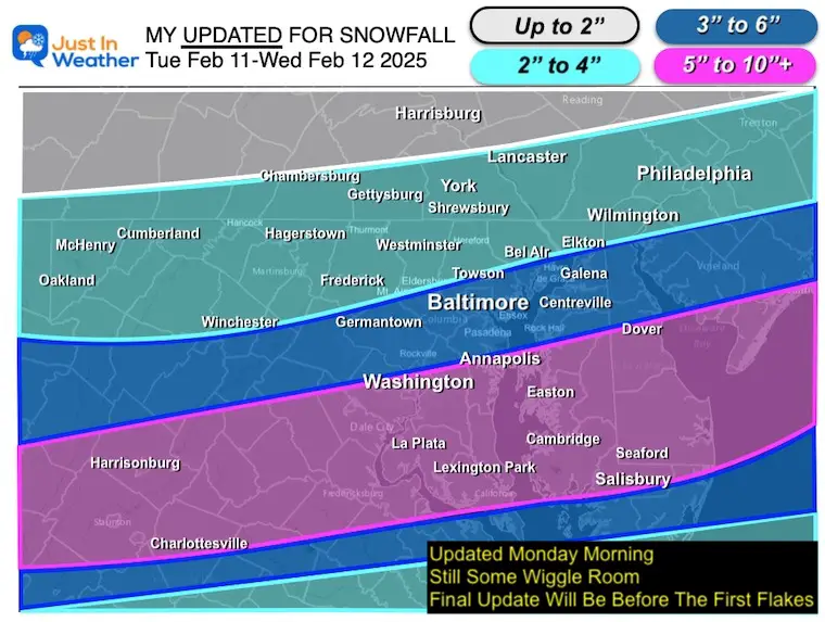
This next storm looks similar to the one we had on January 6. The track will favor heavier snow south of Baltimore and Washington, with less snow to the north. There is still some wiggle room with the banding of snow, and I have adjusted my maps accordingly.
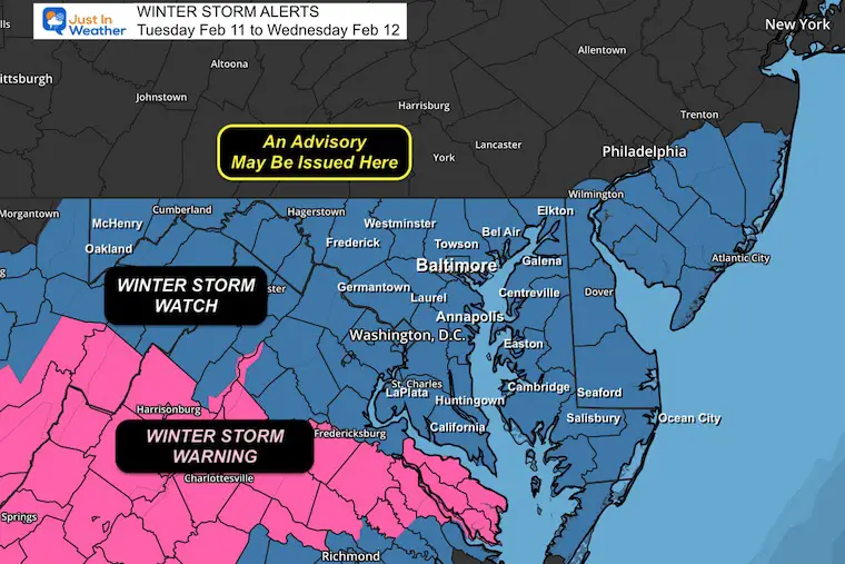
Winter Storm Alerts
A Winter Storm Watch has been expanded to cover the northern counties in Maryland, while an upgraded Winter Storm Warning has been issued for the heavy snow zone in South Central Virginia.
I do expect more alerts likely to be A Winter Weather Advisory to include Southern Pennsylvania. The National Weather Service will post their updates during the day today. I can’t do that for them.
The timing brings in the snow into central Maryland during Tuesday afternoon, with the main impact overnight and ending Wednesday morning, the the next system will bring freezing rain, turning to rain with a warmer track Wednesday night and ending Thursday morning.
Another warm storm with rain this weekend will follow, but the first impact of the next Polar Vortex push will be early next week.
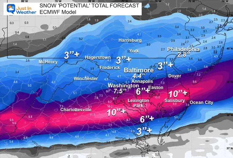
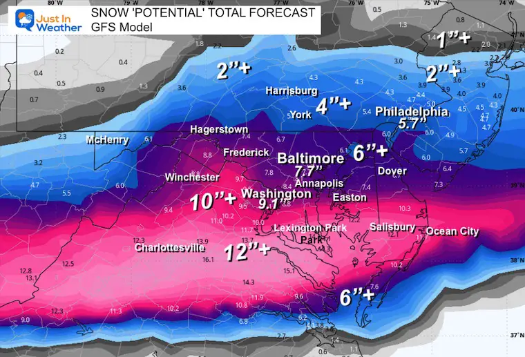
The next focus is on the Snowstorm from Tuesday to Wednesday. Yes, it looks like moderate to heavy snow is expected across the Mid-Atlantic and, once again, may favor areas south of Baltimore. I have the forecast including My First Call For Snowfall and two computer models to compare and contrast.
CLIMATE DATA: Baltimore
TODAY February 10
Sunrise at 7:04 AM
Sunset at 5:38 PM
Normal Low in Baltimore: 26ºF
Record -7F in 1899
Normal High in Baltimore: 45ºF
Record 66ºF 1959; 1960; 2023
Baltimore Seasonal Snow
8.9”
DROUGHT UPDATE
Rainfall Deficit at BWI
- Ending 2024 = -8.00″, since Jan 1 = -1.90
- So we are down -9.90″, including last year!
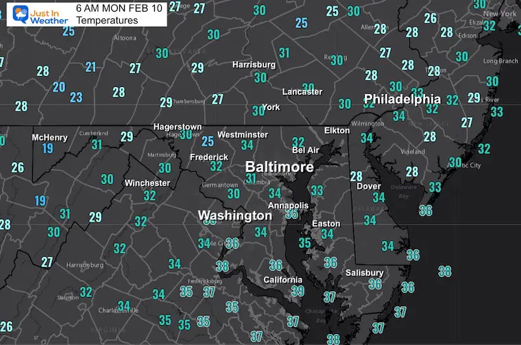
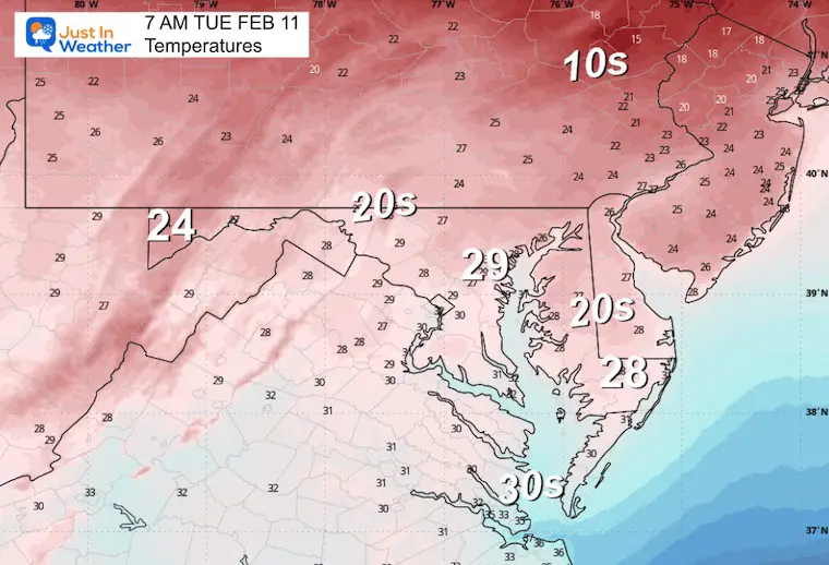
Morning Temperatures
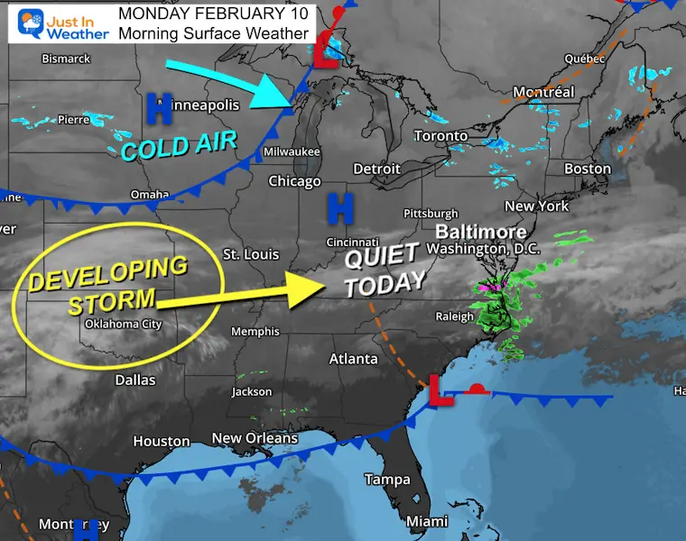
Morning Surface Weather
We get a quiet day and the storm on the way has not formed yet. It will begin to take shape by the end of today.
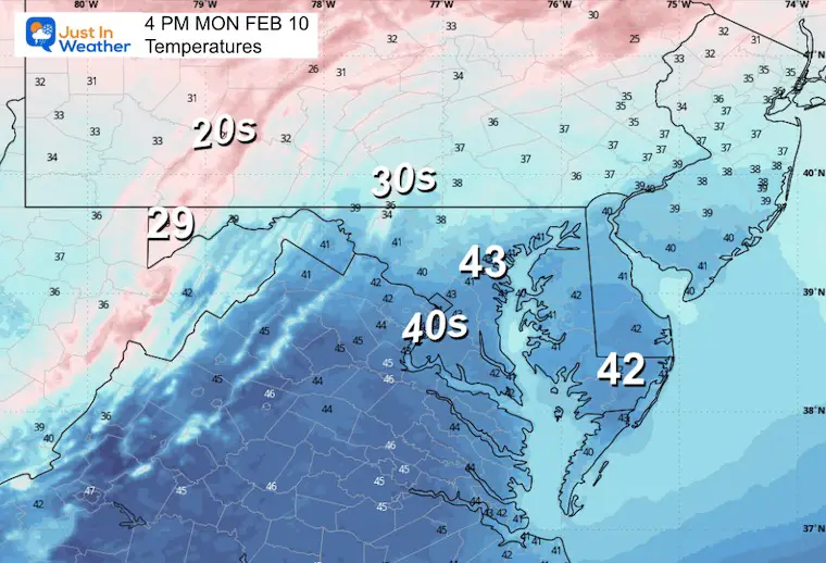
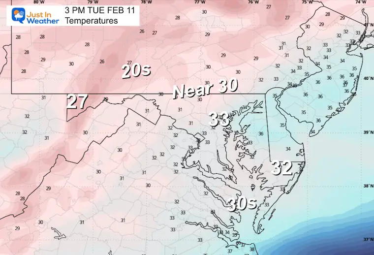
Afternoon Temperatures
TUESDAY WEATHER
Snow will arrive in the afternoon
Morning Temperatures
Afternoon Temperatures
Temps will cool as the snow arrives.
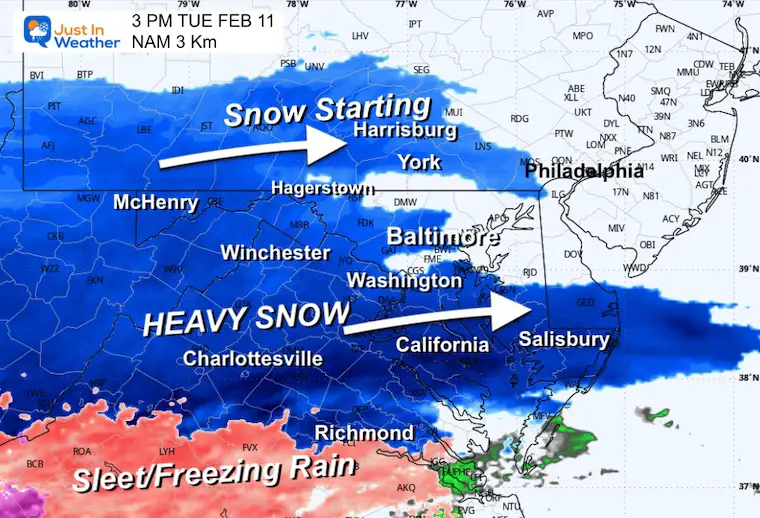
Afternoon Radar Snapshot
Tuesday Snow To Thursday Mix
Forecast Animation ECMWF Model
7 AM Tue to 1 PM Thu
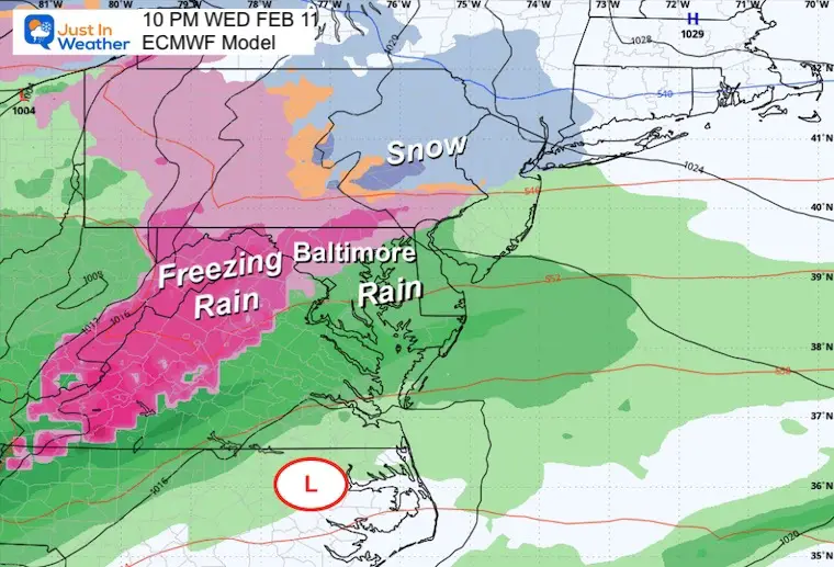
This is the model solution I believe is best at this time. It brings in moderate to heavy snow Tuesday afternoon and night. Heavier snow is plotted near and south of Baltimore so less will fall north.
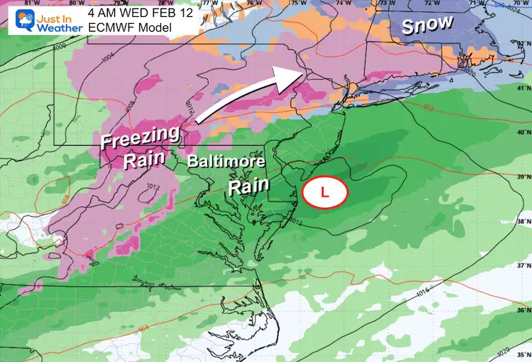
The first wave will end with snow on Wednesday morning. Then freezing rain and rain will arrive Wednesday night, transitioning to all rain Thursday.
This is subject to refining as we get closer.
Snapshots
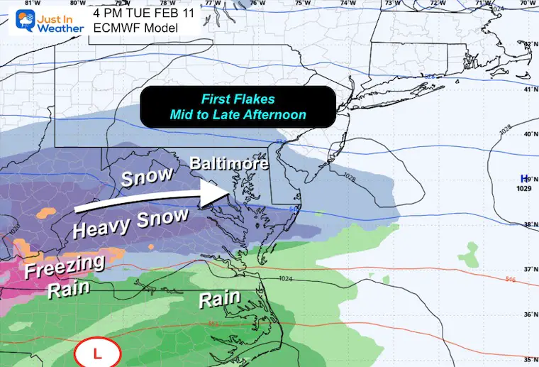
Afternoon at 4 PM
Moderate to Heavy Snow will be developing all afternoon across Virginia into Central and Southern Maryland.
Lighter snow will begin across PA a few hours later…
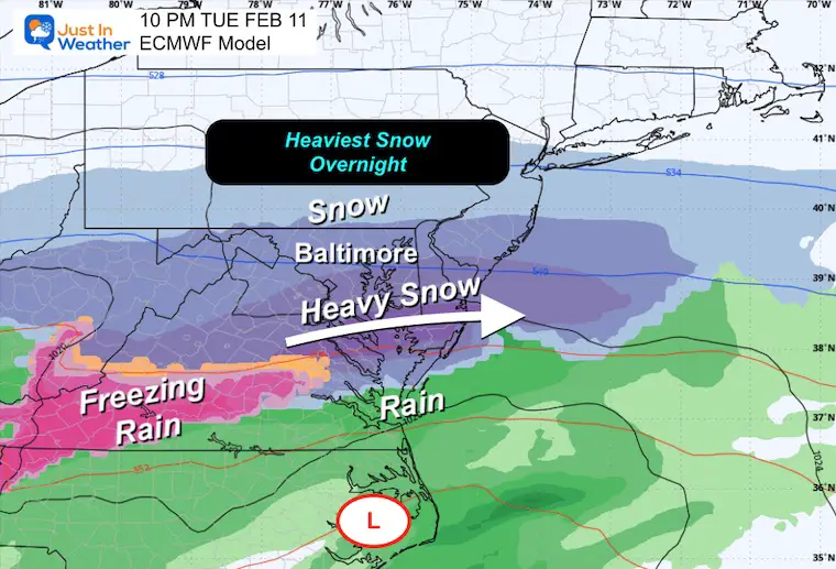
Tuesday Night at 10 AM
Moderate to Heavy Snow will track across Central and Southern Maryland. Steady snow will impact Southern PA as well…
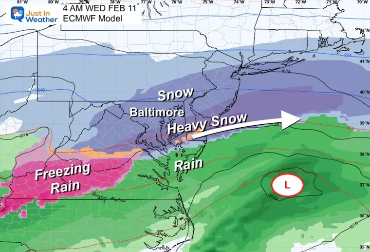
Wednesday Morning at 4 AM
The heavy snow will be moving away around sunrise.
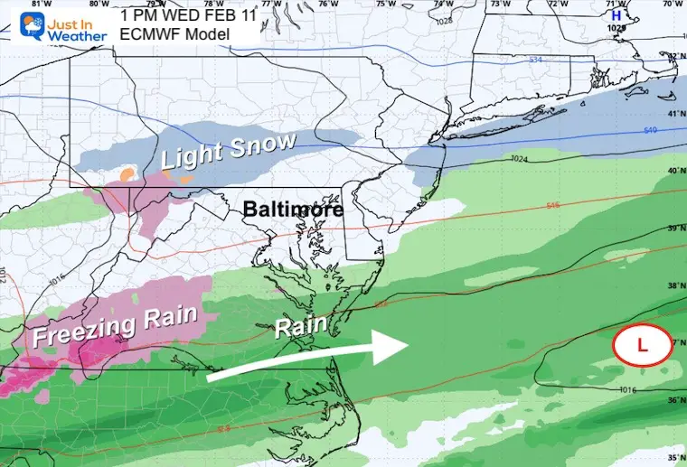
Wednesday Afternoon
NOTE:
Phase 1 will end as snow on Wednesday Morning.
Snow Total Potential
My UPDATED Call For Snowfall
I shaved off the north end and bumped up the heavy snow zone. There is still wiggle room, and I expect one more final adjustment before the first flakes.
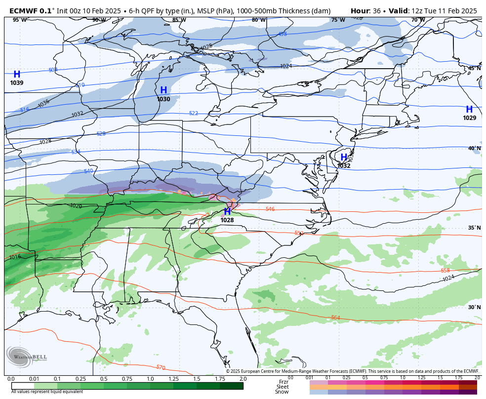
ECMWF Model Forecast
GFS Model Forecast
NAM 3Km Forecast
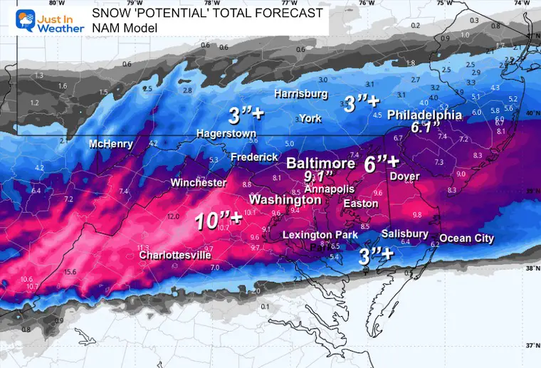
Note: I do not trust the Canadian or other global models in this pattern or time frame.
The HRRR Model (18 hours) and NAM 3 Km (60 hours) Models are short-range products. They do not go out far enough to include this entire event time window.
Phase 2 will begin Wednesday Night with Freezing Rain and Rain, trending warmer.
10 PM Wednesday Night
4 AM Thursday Morning
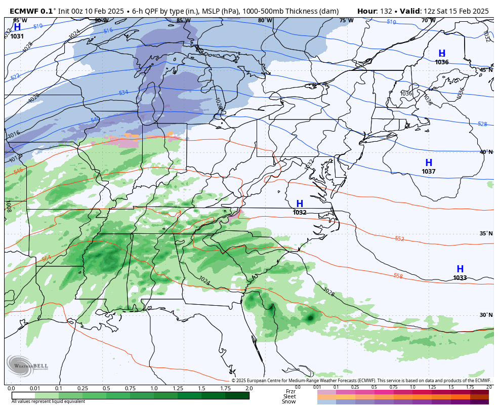
Weekend Storm
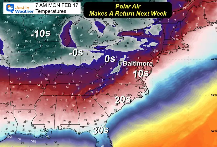
This looks like a warmer track with rain, followed by the first influence from the Polar Vortex, arriving with arctic air on Monday.
Monday Morning Temperatures
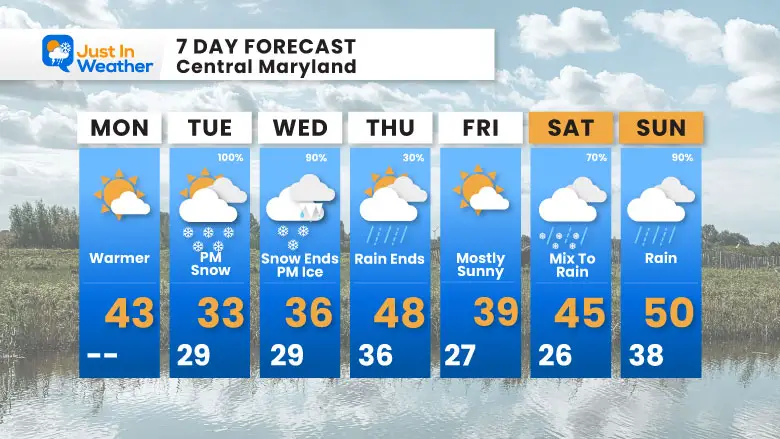
7 Day Forecast
Focus on the snow Tuesday into Wednesday morning.
Then Freezing Rain to Rain Thursday…
More will be in the pipeline as we watch the Polar Vortex’s influence in the week following this time window.
Subscribe for eMail Alerts
La Nina Advisory January 2025
Full Report

MY WINTER OUTLOOK
My Winter Outlook Report

ALSO SEE
Recent Snow Reports
SNOW REPORTS THIS SEASON
Click on the maps for that full report.
January 19 Snow Report

January 11 Snow Report

January 6 Snow Report

Previous Snow

FITF Gear on Sale

In Case You Missed This
The Faith In The Flakes Dec 5 Origin Story

Please share your thoughts and best weather pics/videos, or just keep in touch via social media.
SCHEDULE A WEATHER BASED STEM ASSEMBLY
Severe Weather: Storm Smart October and next spring Winter Weather FITF (Faith in the Flakes): November To March Click to see more and send a request for your school.

THANK YOU:
Baltimore Magazine Readers Choice Best Of Baltimore
Maryland Trek 11 Day 7 Completed Sat August 10
We raised OVER $104,000 for Just In Power Kids – AND Still Collecting More
The annual event: Hiking and biking 329 miles in 7 days between The Summit of Wisp to Ocean City.
Each day, we honor a kid and their family’s cancer journey.
Fundraising is for Just In Power Kids: Funding Free Holistic Programs. I never have and never will take a penny. It is all for our nonprofit to operate.
Click here or the image to donate:

RESTATING MY MESSAGE ABOUT DYSLEXIA
I am aware there are some spelling and grammar typos and occasional other glitches. I take responsibility for my mistakes and even the computer glitches I may miss. I have made a few public statements over the years, but if you are new here, you may have missed it: I have dyslexia and found out during my second year at Cornell University. It didn’t stop me from getting my meteorology degree and being the first to get the AMS CBM in the Baltimore/Washington region. One of my professors told me that I had made it that far without knowing and to not let it be a crutch going forward. That was Mark Wysocki, and he was absolutely correct! I do miss my mistakes in my own proofreading. The autocorrect spell check on my computer sometimes does an injustice to make it worse. I also can make mistakes in forecasting. No one is perfect at predicting the future. All of the maps and information are accurate. The ‘wordy’ stuff can get sticky. There has been no editor who can check my work while writing and to have it ready to send out in a newsworthy timeline. Barbara Werner is a member of the web team that helps me maintain this site. She has taken it upon herself to edit typos when she is available. That could be AFTER you read this. I accept this and perhaps proves what you read is really from me… It’s part of my charm. #FITF


