Sunday Afternoon Update
This week will be our prime time of winter. The majority of years we get a winter storm close to Presidents Week. This time, we have two storms back to back, and they will behave differently. The first will bring snow that looks to be heavier south of Baltimore, like the storm we had on January 6. The second storm will follow a warmer track with a change to freezing rain and ending with snow.
Our biggest impact will be Tuesday evening through Wednesday.
Before we get into this, I need to emphasize two things:
1: Compare Models are guidance. I pick among many which to show based on which I think I performing best. They are subject to change and shift in both the timing and track. So, with two days away, I leave a little wiggle room.
2: My First Call For Snowfall is my highest confidence on the lower end. It may not match the models and, in some cases, can be much lower. This is intentional as I leave room to go up as we get closer. Computer models on the other hand, more often will pull back down from higher numbers.
UPDATED MONDAY AFTERNOON
WINTER STORM WARNING AND ADVISORY ISSUED BY NWS
Click here or the map for the full report: my updated call for snowfall, and more model map.
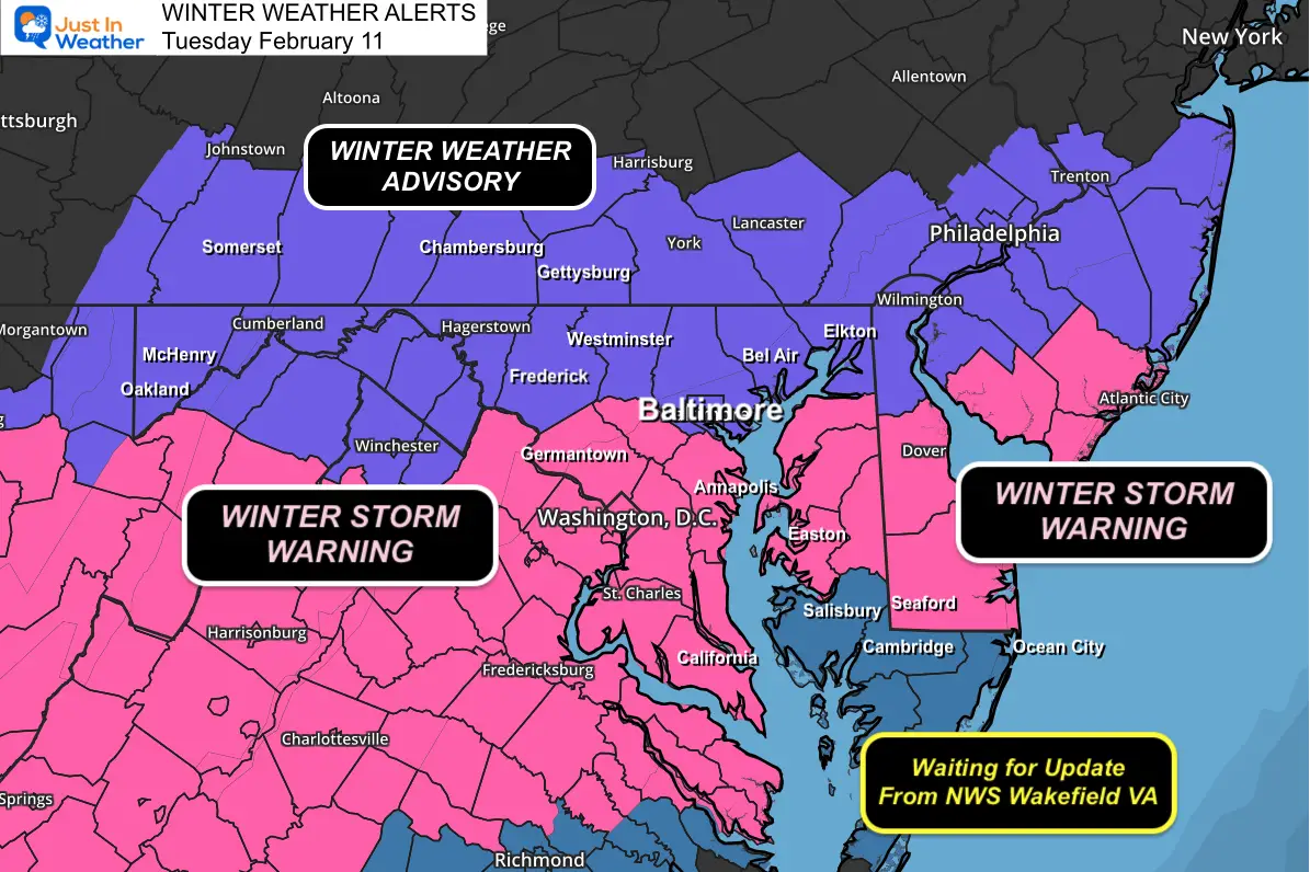
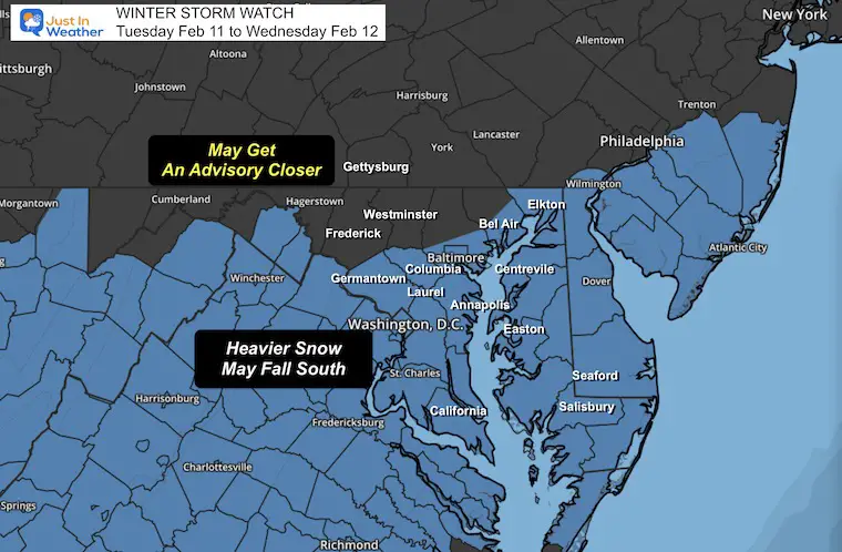
Winter Storm Watch: From The National Weather Service
Tuesday Afternoon to Wednesday Afternoon
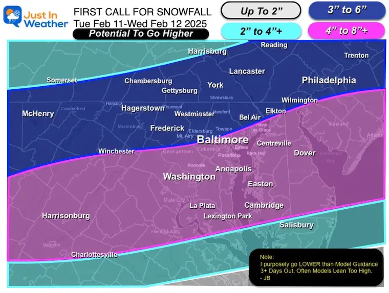
Potential for a range of 4 to 6 inches of snow (or higher further south).
This includes Baltimore, Washington, and just east of Philadelphia: All areas South and East of I-95. This is the expected highest-impact zone
Inland areas to the north along the MD/PA line are likely to get a Winter Weather Advisory as we get closer.
Mid Week Set Up
Two Storms…. The first one will dump snow in the Mid-Atlantic and move more zonally, West to East. This is due to being blocked by strong High Pressure in New England, the source of the cold air.
The second storm in the Central US will ride the jet stream as it lifts North. That is why we expect this storm to be warmer and bring us rain.
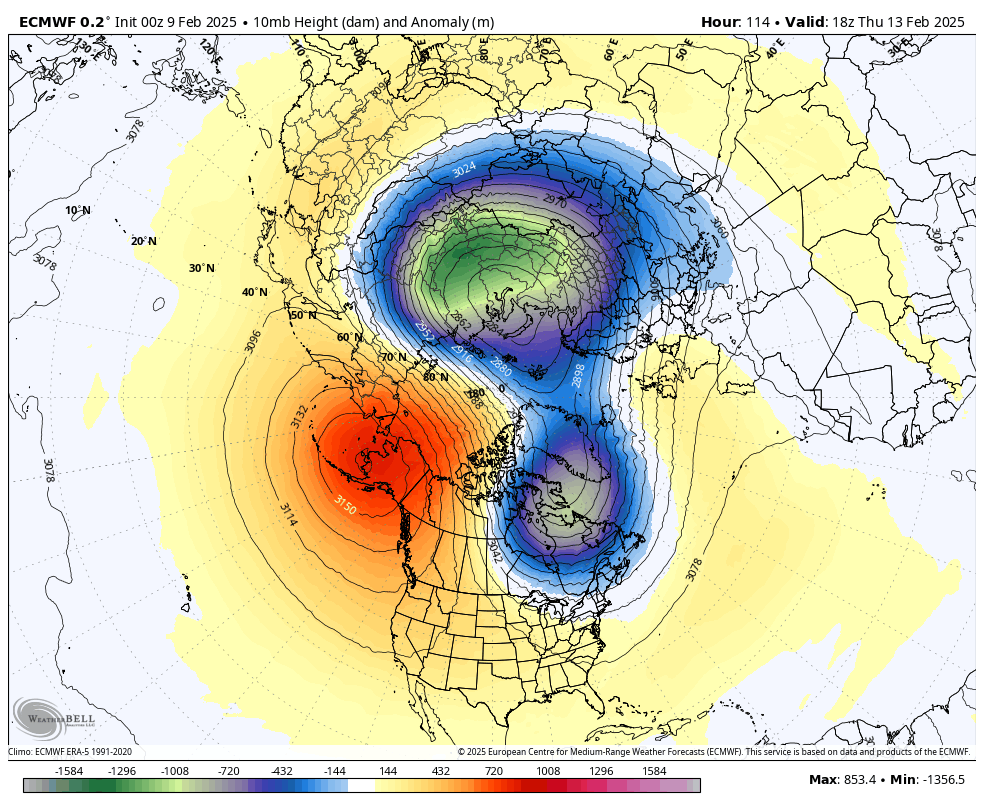
Jet Stream Set Up
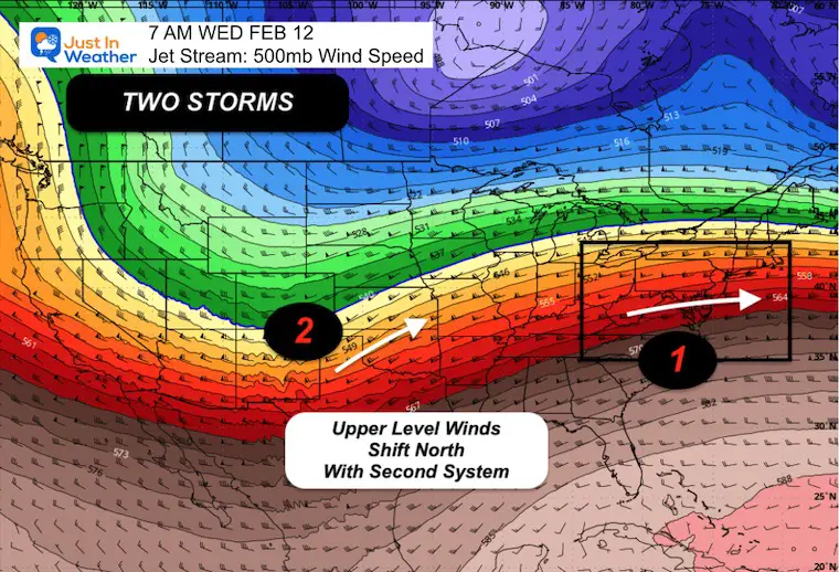
Jet Steam Forecast Tuesday to Thursday
Here, we can see the lifting track to our North.
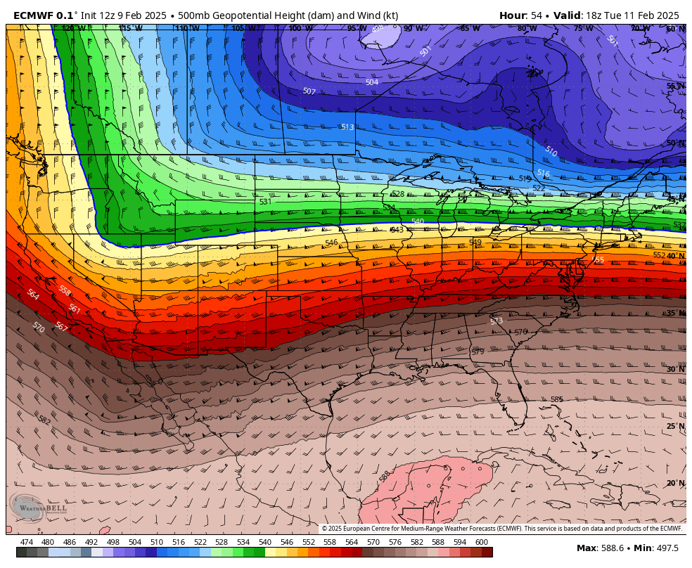
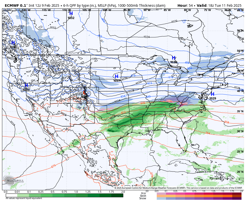
National Forecast: ECMWF Model Tuesday to Thursday
The surface reflection of that lifting jet steam is the shift from snow (blue) with the first storm to freezing rain (pink) and rain (green) with the second storm.
Closer Look Tuesday Afternoon to Thursday Afternoon
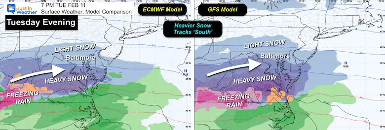
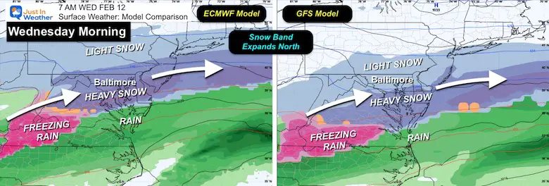
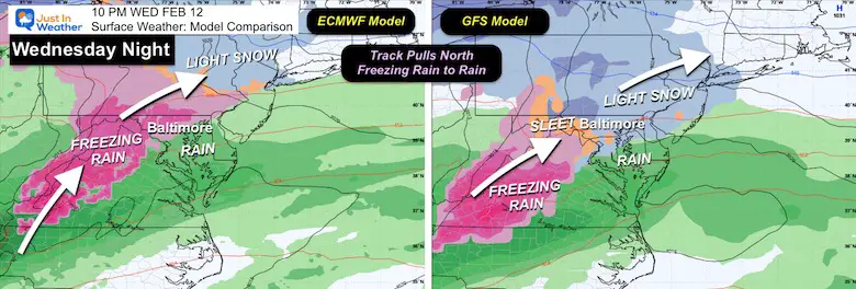
Model Comparison
ECMWF to GFS
Very similar solutions. I am leaning on the European Model with these differences:
Later start Tuesday, but longer duration snow into Wednesday.
The second event may bring more Freezing Rain, but will end with rain overnight into Thursday Morning.
Tuesday Evening
Wednesday Morning
Wednesday Night
Snow POTENTIAL Forecasts
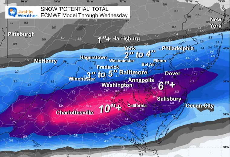
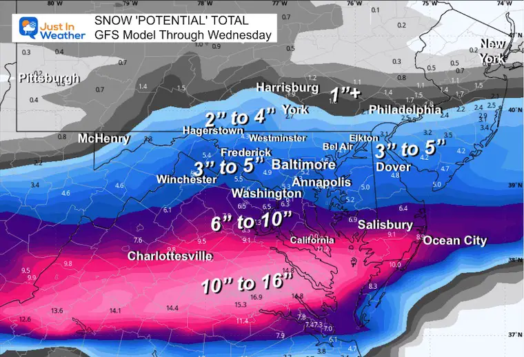
The take away here is that the heavier snow is set up like January 6 to fall more south of Baltimore across South Central Virginia to Southern Maryland.
There is wiggle room! These models have a tendency to overplay snow totals AND can bump back north just before an event.
My First Call accounts for that. That is why I started lower with totals and left room to increase. Also, I did account for the expansion of a little more snow farther north near the PA line.
My First Call For Snowfall
I am hedging my initial call that this tracks a little farther north. That keeps Southern PA in play for slightly more than the models suggest.
ECWMF Model
GFS Model
Looking Ahead: Polar Vortex Forecast
Polar Vortex Forecast Feb 13 to 19
The split and then the surge of cold air into the United States.
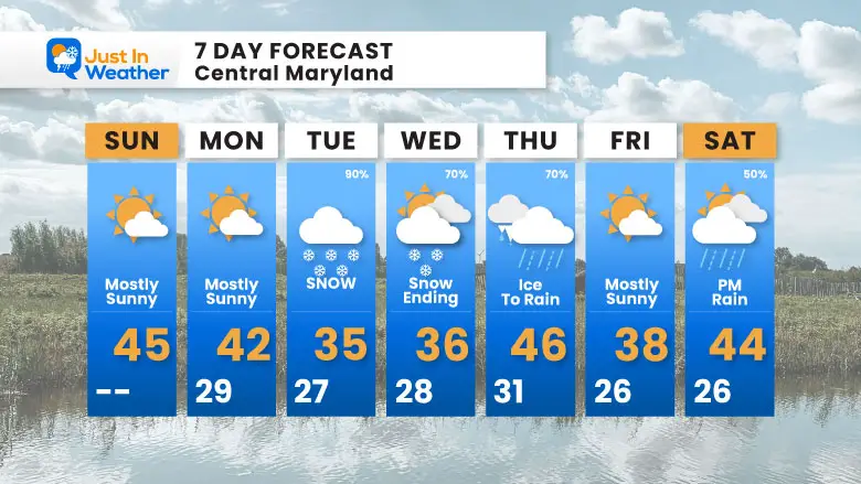
7 Day Forecast
Focus on the snow Tuesday into Wednesday morning.
Then Freezing Rain to Rain Thursday…
More will be in the pipeline as we watch the Polar Vortex’s influence in the week following this time window.
Subscribe for eMail Alerts
La Nina Advisory January 2025
Full Report

MY WINTER OUTLOOK
My Winter Outlook Report

ALSO SEE
Recent Snow Reports
SNOW REPORTS THIS SEASON
Click on the maps for that full report.
January 19 Snow Report

January 11 Snow Report

January 6 Snow Report

Previous Snow

FITF Gear on Sale

In Case You Missed This
The Faith In The Flakes Dec 5 Origin Story

Please share your thoughts and best weather pics/videos, or just keep in touch via social media.
SCHEDULE A WEATHER BASED STEM ASSEMBLY
Severe Weather: Storm Smart October and next spring Winter Weather FITF (Faith in the Flakes): November To March Click to see more and send a request for your school.

THANK YOU:
Baltimore Magazine Readers Choice Best Of Baltimore
Maryland Trek 11 Day 7 Completed Sat August 10
We raised OVER $104,000 for Just In Power Kids – AND Still Collecting More
The annual event: Hiking and biking 329 miles in 7 days between The Summit of Wisp to Ocean City.
Each day, we honor a kid and their family’s cancer journey.
Fundraising is for Just In Power Kids: Funding Free Holistic Programs. I never have and never will take a penny. It is all for our nonprofit to operate.
Click here or the image to donate:

RESTATING MY MESSAGE ABOUT DYSLEXIA
I am aware there are some spelling and grammar typos and occasional other glitches. I take responsibility for my mistakes and even the computer glitches I may miss. I have made a few public statements over the years, but if you are new here, you may have missed it: I have dyslexia and found out during my second year at Cornell University. It didn’t stop me from getting my meteorology degree and being the first to get the AMS CBM in the Baltimore/Washington region. One of my professors told me that I had made it that far without knowing and to not let it be a crutch going forward. That was Mark Wysocki, and he was absolutely correct! I do miss my mistakes in my own proofreading. The autocorrect spell check on my computer sometimes does an injustice to make it worse. I also can make mistakes in forecasting. No one is perfect at predicting the future. All of the maps and information are accurate. The ‘wordy’ stuff can get sticky. There has been no editor who can check my work while writing and to have it ready to send out in a newsworthy timeline. Barbara Werner is a member of the web team that helps me maintain this site. She has taken it upon herself to edit typos when she is available. That could be AFTER you read this. I accept this and perhaps proves what you read is really from me… It’s part of my charm. #FITF


