


January 6 Weather Some Fog And Clouds Followed By The Warm Up With Rain By The Weekend
Tuesday, January 6, 2026 The storm track has shifted to the north. We are still on the edge, which is why we have areas of fog, and most of the…
Thursday Night Update February 6, 2025
February is known for the bulk of winter weather in our region. We are about to get a few winter storms, starting with ice this weekend and snow early next week.
Locally, we fondly refer to Presidents Week for nearly half of our top 25 snowstorms. As history would have it, today is part of the Anniversary of our Double Blizzards. In 2010, Baltimore had one on Feb 5-6, then again on Feb 9-10. Both were officially blizzards that brought a total of 50 inches of snow in the snowiest winter on record.
What we have in front of us is not the same because we are not looking at all snow. Multiple storm systems will arrive every two to three days. Much like the ice event that just passed through, the track may look like Atmospheric Memory is stuck on repeat.
I am only going out one week here, but there is more in the pipeline. I am more confident in the short-range events. While the pattern will keep sending impulses our way, farther out in time, the track and impact get more challenging to pin down.
Also, I will show the ice forecast for our first event on Saturday. The second event will bring more snow, but I do not trust the wide range of model forecasts. I never show a hint of snow totals until we are within 72 hours of that event.
Basically, this is going to be rapid-fire and changing, so each update will get a little more specific as we approach each event.
The Northern and Southern branches of the Jet Stream are locked in a position to help develop new Low-Pressure systems in the Mississippi River Valley that track across the Mid Atlantic… like this:
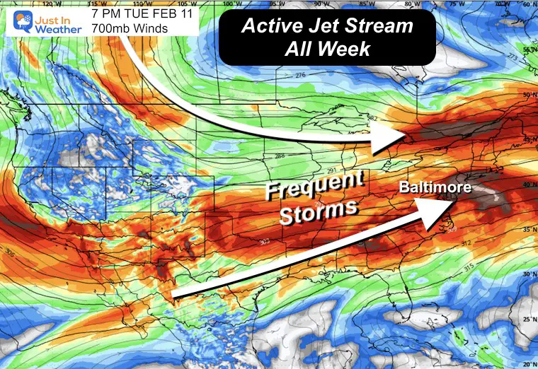
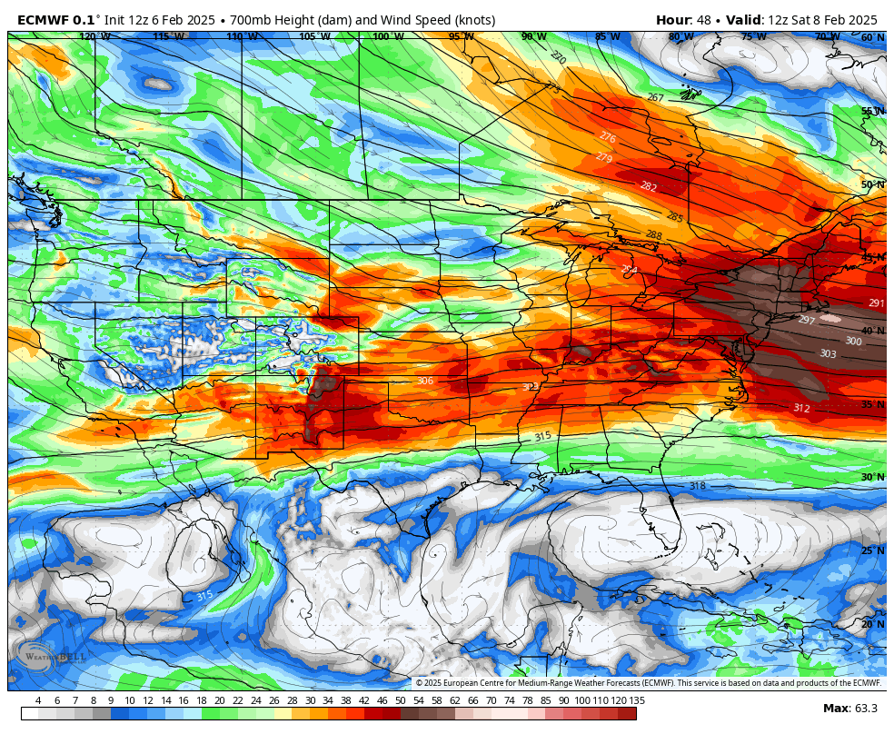
This is the air flow at around 10,000 ft elevation. I chose this because it helps demonstrate the activity on the way.
The next two winter weather systems… and there are more to follow afterward.
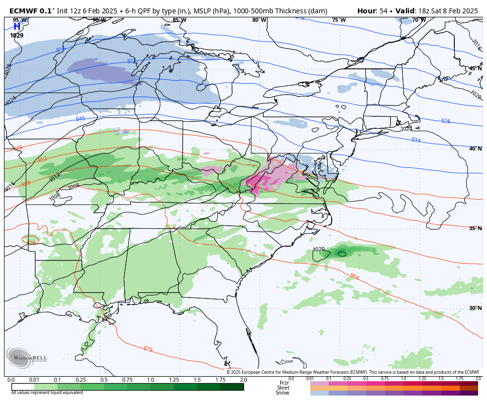
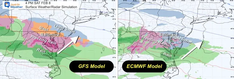
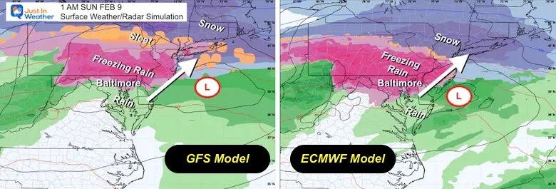
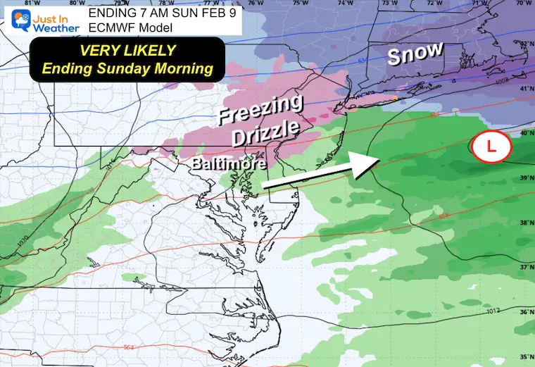
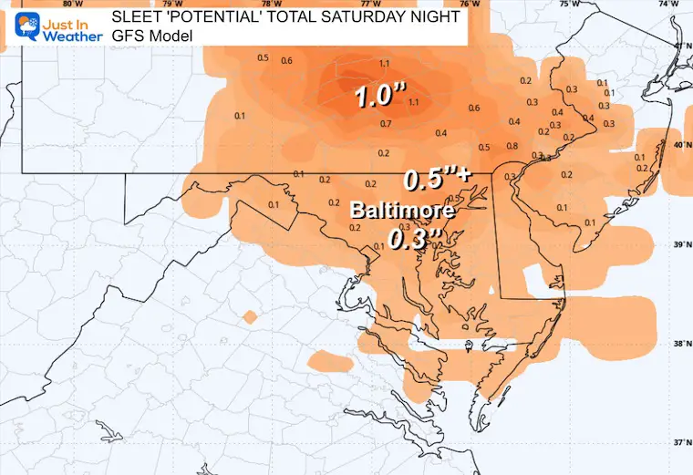
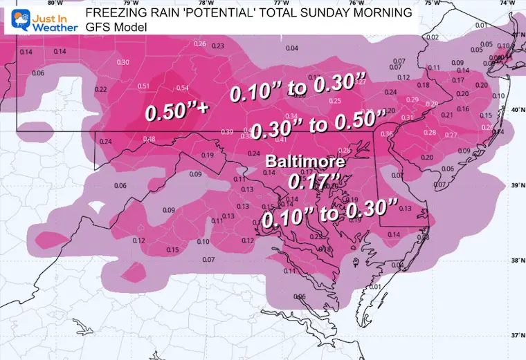
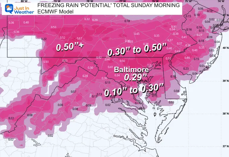
The GFS Model is more aggressive, with earlier arrival and sleet. The ECWMF Model is slower and starts with light snow.
Both models bring in moderate freezing rain all evening and overnight. This will end Sunday morning.
Both models bring in accumulating snow during the day and lasting into the night.
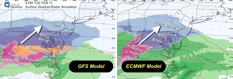
This may start with light snow or sleet in the afternoon.
Freezing rain is most likely with moderate icing overnight.
Moderate to Heavy Icing Near and North of Baltimore.
This may play out in a very similar way to what we just had on Thursday morning.
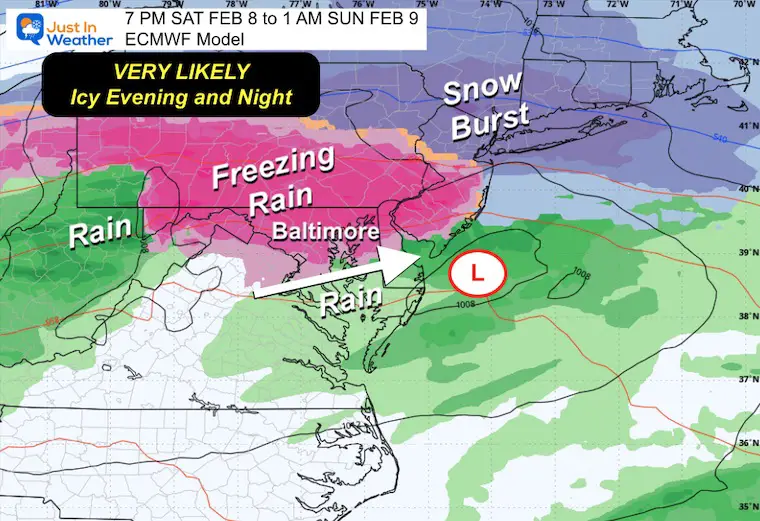
Any leftover icing will be ending… With plenty of day hours to clear roads. Super Bowl party plans should not have a weather impact.
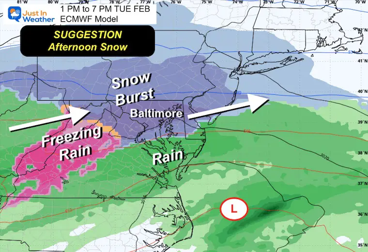
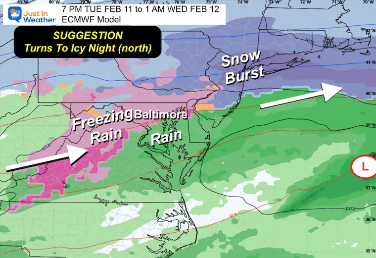
I’m comparing the GFS and ECMWF Models again like the last event.
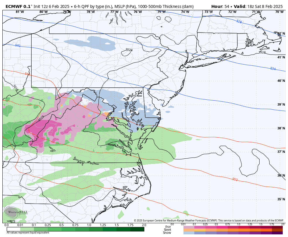
This is the only one showing significant sleet.
This looks like a daytime arrival with a snow burst. If this holds, it will drag in warmer air to turn to freezing rain overnight…
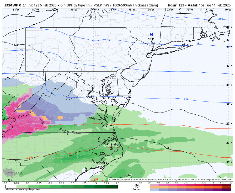
This snow burst would bring accumulation and impact! I will NOT show snow total potential because there is a wide range with models now, and I do not think they have a good handle on it yet.
Considering the pattern we are in, there is a chance to turn to freezing rain with rain in the warmer areas near and south of Baltimore.
Sign up and be the first to know!


Click on the maps for that full report.


Severe Weather: Storm Smart October and next spring Winter Weather FITF (Faith in the Flakes): November To March Click to see more and send a request for your school.

The annual event: Hiking and biking 329 miles in 7 days between The Summit of Wisp to Ocean City.
Each day, we honor a kid and their family’s cancer journey.
Fundraising is for Just In Power Kids: Funding Free Holistic Programs. I never have and never will take a penny. It is all for our nonprofit to operate.
Click here or the image to donate:

I am aware there are some spelling and grammar typos and occasional other glitches. I take responsibility for my mistakes and even the computer glitches I may miss. I have made a few public statements over the years, but if you are new here, you may have missed it: I have dyslexia and found out during my second year at Cornell University. It didn’t stop me from getting my meteorology degree and being the first to get the AMS CBM in the Baltimore/Washington region. One of my professors told me that I had made it that far without knowing and to not let it be a crutch going forward. That was Mark Wysocki, and he was absolutely correct! I do miss my mistakes in my own proofreading. The autocorrect spell check on my computer sometimes does an injustice to make it worse. I also can make mistakes in forecasting. No one is perfect at predicting the future. All of the maps and information are accurate. The ‘wordy’ stuff can get sticky. There has been no editor who can check my work while writing and to have it ready to send out in a newsworthy timeline. Barbara Werner is a member of the web team that helps me maintain this site. She has taken it upon herself to edit typos when she is available. That could be AFTER you read this. I accept this and perhaps proves what you read is really from me… It’s part of my charm. #FITF