Wednesday Night Update February 5 2025
As I write this report, temperatures across most of our region are still above freezing. I’ve been in this situation many times where there is doubt the ice will really happen. The setup is mostly as planned. The precipitation may be an hour or two later… but it will arrive.
I have been considering that Sunday, January 19 event, when the temperatures were a little warmer, and the snow impact was a few hours later. The dark hours in this overnight event should still allow the cold to take hold.
The latest forecast totals also suggest the accrued ice build up will have an impact and take time to melt. Even if we get half of what these models suggest, it will be worth waiting out.
In addition to this last focus on the timeline, we have a very active few weeks ahead. My 9th-grade son has been watching closely, and we had a little wager… I lost. So, I must honor his request to post a look at the multiple winter storms shown on the European Model for the next 12 days. I will show them below.
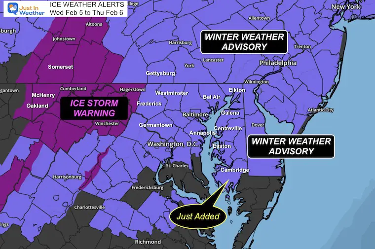
The Ice Storm Warning and Winter Weather Advisory in place will be valid mostly overnight into the daybreak hours. We just trust the physics of the atmosphere to cool a few more degrees and lock us in for roughly 6 hours or more of sleet and freezing rain.
I stand by this statement: This is the worst weather to travel in, you can’t play in it, and there is a high chance of school impact on Thursday. Many have made an early call to delay or go virtual. Others may decide in the morning where the impact may be marginal. Some areas will get icy and start to thaw before sunrise. This may include Annapolis to Easton and Cambridge in Maryland.
Winter Weather Alerts
Honestly, this can be confusing. There will be more ice that can weigh heavier and take longer to melt farther west and north.
Ice Storm Warning: Up to 1 inch of sleet and 0.3” of freezing rain (Maryland Mountains)
This is similar to the forecast for Central PA however they are under A Winter Weather Advisory
Winter Weather Advisory (MD and VA): Up to 1” sleet and 0.10” to 0.20” Freezing Rain
As for the totals, there may be areas over 1/4 inch, which can break some branches and lead to some power outages. Two things to keep in mind with an ice storm:
- Once we get into a cold air dam with ice, it is very difficult or models to predict when it will lift and thaw.
- Even when the temps warm above 32F, it will take time for the ice to thaw. So it doesn’t end quickly.
Winter Precipitation
This contrast of sleet and freezing rain seemed to be a hit online this afternoon:
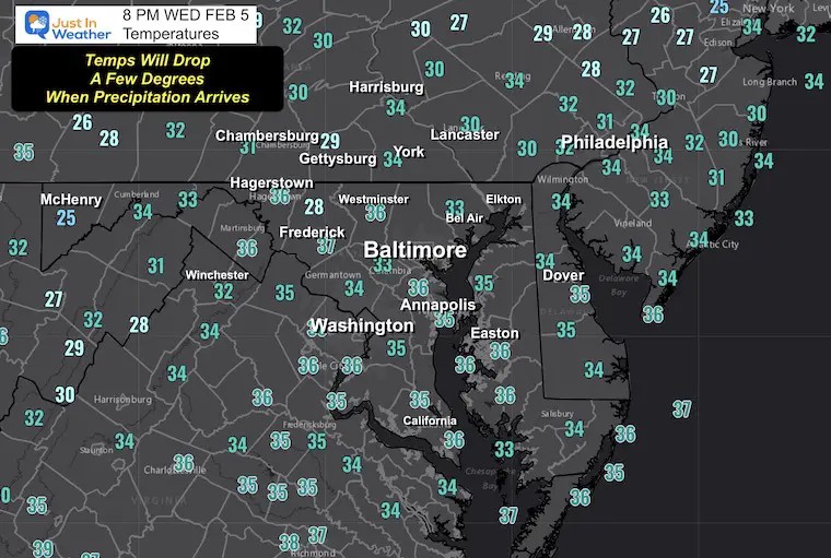
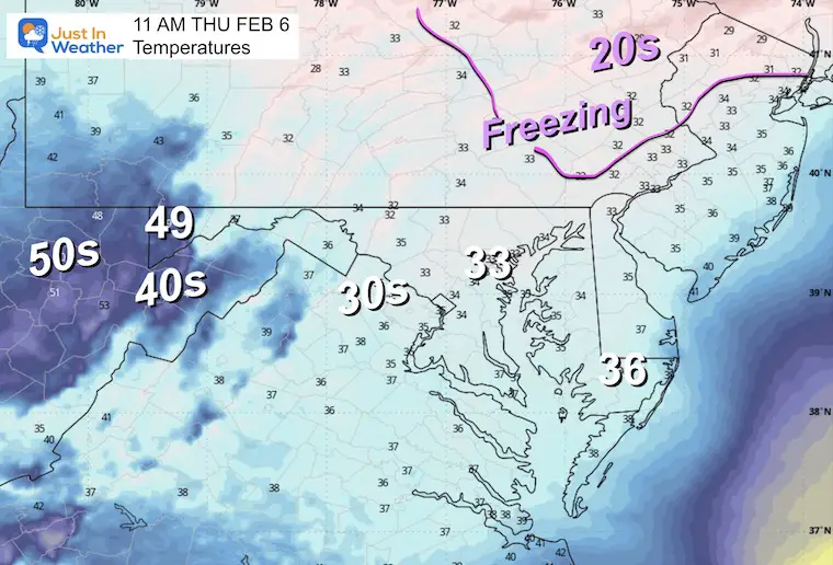
Wednesday Evenings Temperatures
I wanted to compare the 8 PM observations to the updated high resolution NAM 3 Km Model
Observations
Forecast
Using Baltimore as the focus, BWI was just off by 1 degree. That should be negligible as we go forward.
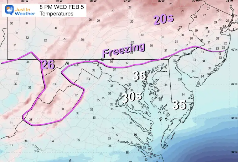
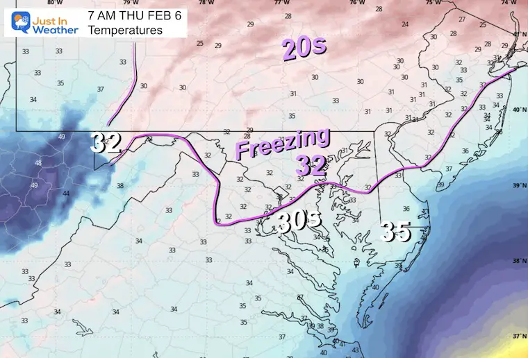
Temperature Forecast
8 PM to 7 AM
The expectation is for temperatures to drop below freezing as the precipitation arrives. Some evaporation will occur, allowing the air to cool a few degrees. Then, temperatures should hold there for most places through sunrise.
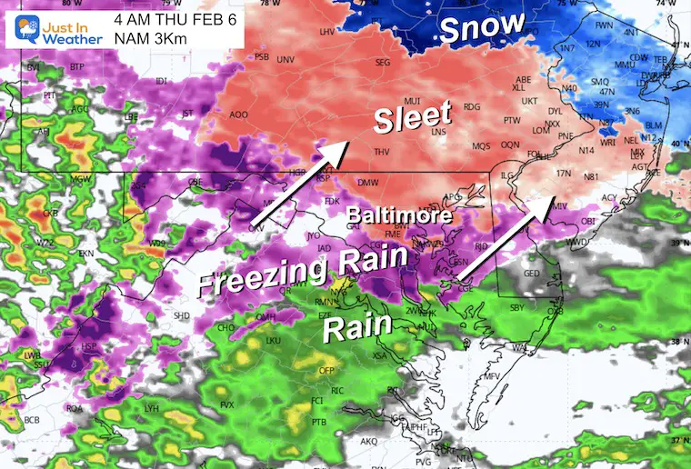
Radar Simulation NAM 3Km
Midnight to 12 PM Thu
Snapshots For Radar and Temperatures
These are suggestions, not promises.
The warming and thaw are very challenging to pin down.
4 AM

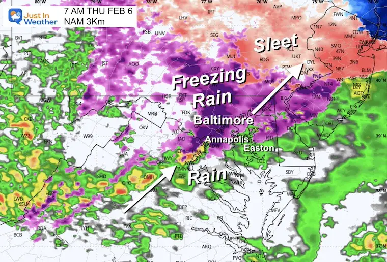
7 AM
The thaw line may be moving north of Annapolis and Easton.
11 AM

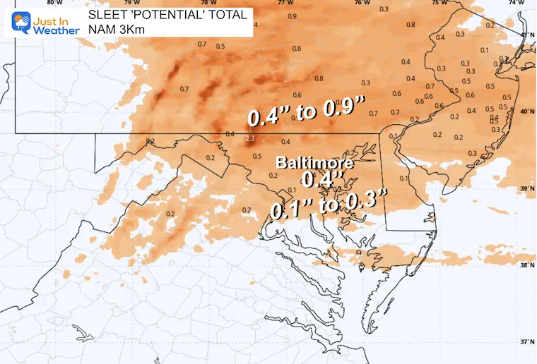
Winter Precipitation POTENTIAL Forecasts
NAM Sleet
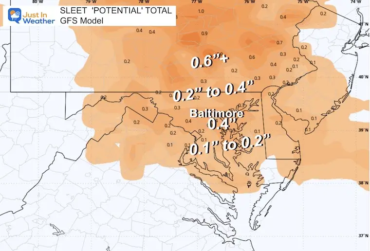
GFS Sleet
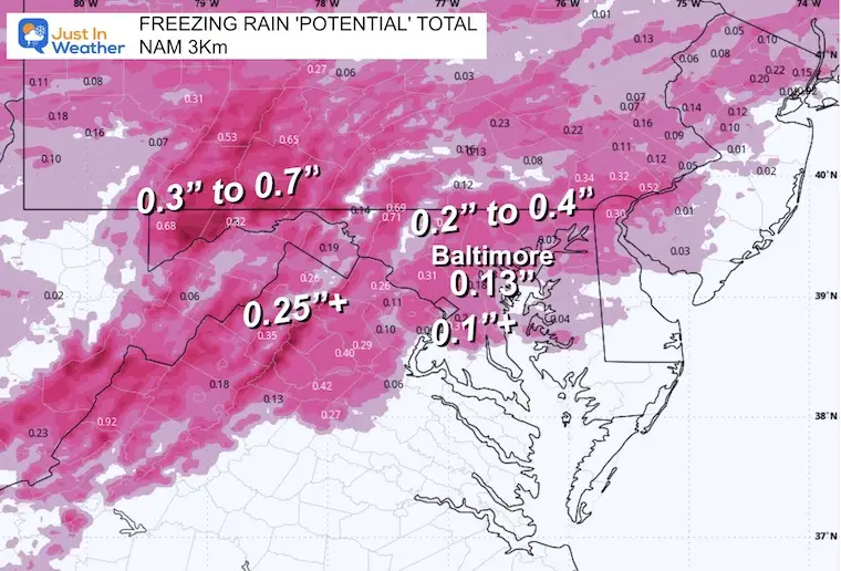
NAM Freezing Rain
GFS Freezing Rain
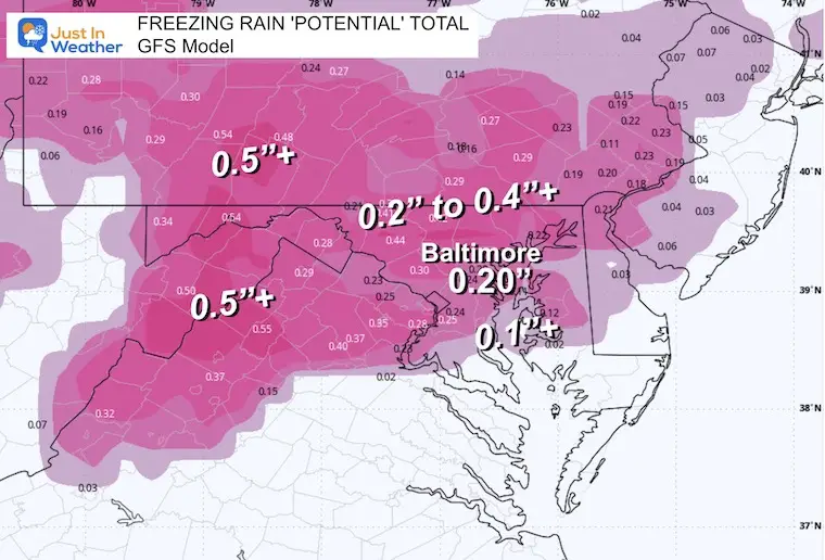
Take Away (Same As Yesterday)
- Thursday morning will thaw gradually from south to north.
- Even if temps warm, ice buildup will take time to melt.
- This should be done before noon.
- A glaze of ice = Travel Problems.
- 0.10” Ice = Moderate Icing, And Some Branches May Fall
- 0.25” to 0.50”+ Ice = Trees and Power Lines start to have more breaks. This would be a widespread disruption.
- Thicker ice also means a longer time to thaw. So temps could warm, but a few additional hours would be needed for melting to allow for safe travel.
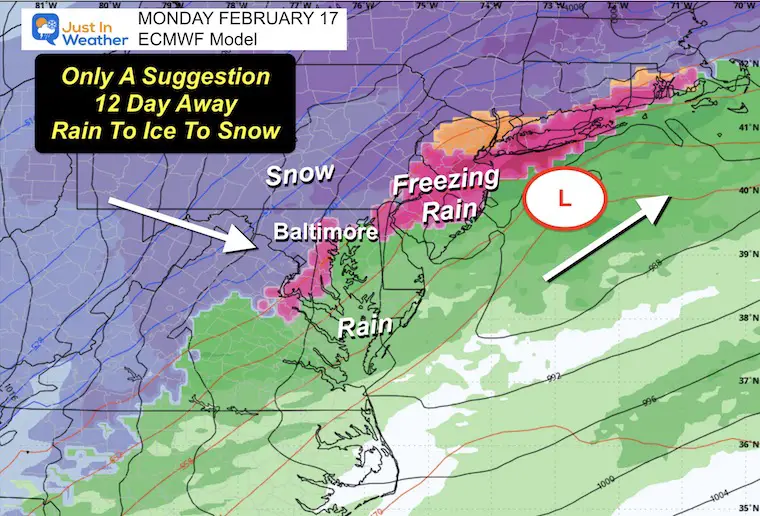
Looking Ahead (Next 12 Days)
As I said above, I lost a bet to my son and am posting this for him. Yes, we will have a very active storm track for a few weeks. The confidence and accuracy go down farther out in time. I am showing potential events but will never suggest snow totals for any event beyond 3 days. That simply is not realistic to be accurate.
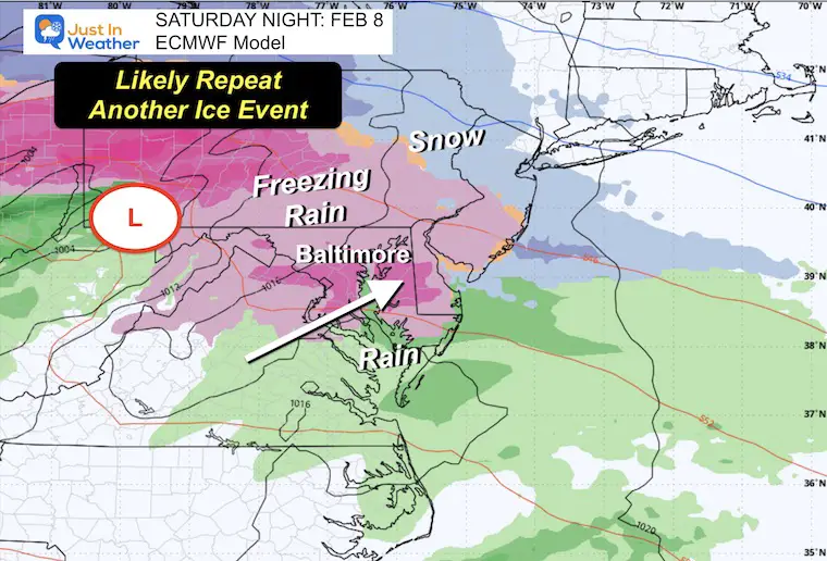
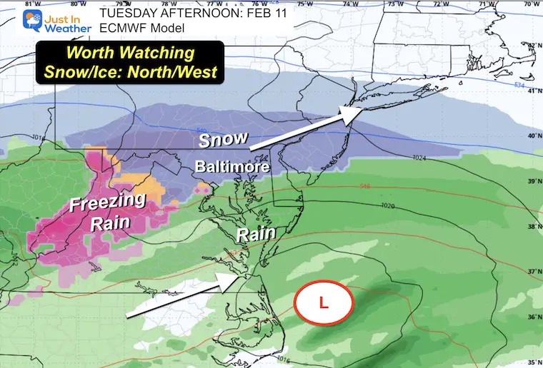
The short-term ice event on Saturday and snow early next week are more probable. The other events are suggestions. I see there will be more with a wandering Arctic boundary. So we may end up on the rain or icy side, ending with the potential for more snow.
Snapshots
Saturday
Tuesday
Next Thursday
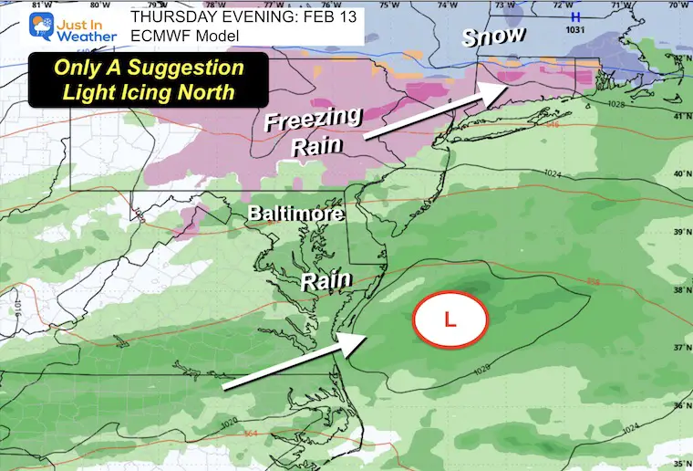
Day 12+: Potential rain and ice ending with snow…
Subscribe for eMail Alerts
La Nina Advisory January 2025
Full Report

MY WINTER OUTLOOK
My Winter Outlook Report

ALSO SEE
Recent Snow Reports
SNOW REPORTS THIS SEASON
Click on the maps for that full report.
January 19 Snow Report

January 11 Snow Report

January 6 Snow Report

Previous Snow

FITF Gear on Sale

In Case You Missed This
The Faith In The Flakes Dec 5 Origin Story

Please share your thoughts and best weather pics/videos, or just keep in touch via social media.
SCHEDULE A WEATHER BASED STEM ASSEMBLY
Severe Weather: Storm Smart October and next spring Winter Weather FITF (Faith in the Flakes): November To March Click to see more and send a request for your school.

THANK YOU:
Baltimore Magazine Readers Choice Best Of Baltimore
Maryland Trek 11 Day 7 Completed Sat August 10
We raised OVER $104,000 for Just In Power Kids – AND Still Collecting More
The annual event: Hiking and biking 329 miles in 7 days between The Summit of Wisp to Ocean City.
Each day, we honor a kid and their family’s cancer journey.
Fundraising is for Just In Power Kids: Funding Free Holistic Programs. I never have and never will take a penny. It is all for our nonprofit to operate.
Click here or the image to donate:

RESTATING MY MESSAGE ABOUT DYSLEXIA
I am aware there are some spelling and grammar typos and occasional other glitches. I take responsibility for my mistakes and even the computer glitches I may miss. I have made a few public statements over the years, but if you are new here, you may have missed it: I have dyslexia and found out during my second year at Cornell University. It didn’t stop me from getting my meteorology degree and being the first to get the AMS CBM in the Baltimore/Washington region. One of my professors told me that I had made it that far without knowing and to not let it be a crutch going forward. That was Mark Wysocki, and he was absolutely correct! I do miss my mistakes in my own proofreading. The autocorrect spell check on my computer sometimes does an injustice to make it worse. I also can make mistakes in forecasting. No one is perfect at predicting the future. All of the maps and information are accurate. The ‘wordy’ stuff can get sticky. There has been no editor who can check my work while writing and to have it ready to send out in a newsworthy timeline. Barbara Werner is a member of the web team that helps me maintain this site. She has taken it upon herself to edit typos when she is available. That could be AFTER you read this. I accept this and perhaps proves what you read is really from me… It’s part of my charm. #FITF


