February 5, 2025
Wednesday Report
There is so much to talk about today. As colder air works back in, a thin band of light snow has developed and coated the ground in Northeastern Maryland. I showed this the last two days but the models struggled with it.
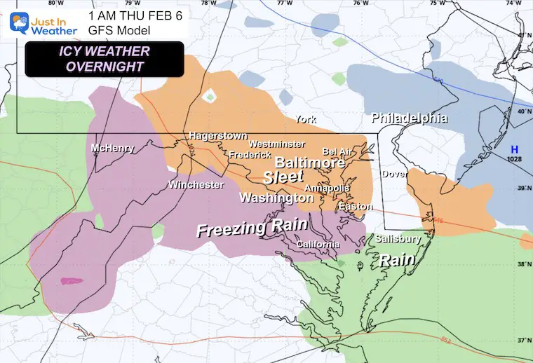
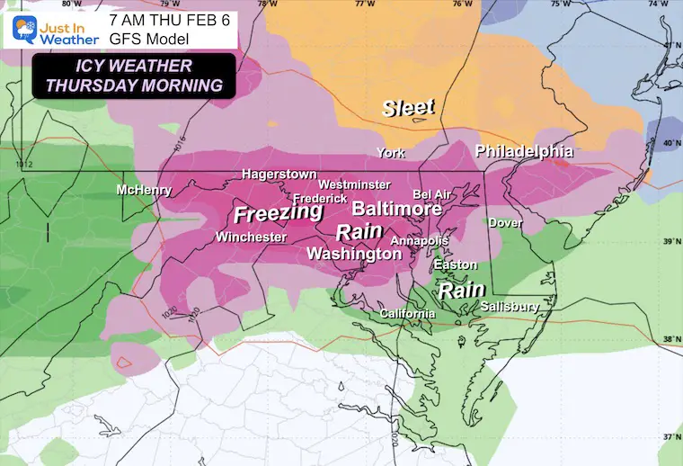
The main focus will be on the developing sleet and freezing rain tonight. The bulk will fall after midnight, with moderate to heavy ice at daybreak. The Winter Weather Advisory in place has been extended to 10 AM in Central Maryland. Also, Dorchester County on the Eastern Shore has been added.
This weekend will bring another icy mix late Saturday, and then an active pattern with colder air will try to produce snow next week.
First, We have a drought and need the moisture in any way it will arrive.
DROUGHT UPDATE
Rainfall Deficit at BWI
Ending 2024 = -8.00″, since Jan 1 = -1.90
So we are down -9.90″, including last year!
CLIMATE DATA: Baltimore
TODAY February 5
Sunrise at 7:09 AM
Sunset at 5:33 PM
Normal Low in Baltimore: 25ºF
Record -1ºF in 1886; 1996
Normal High in Baltimore: 44ºF
Record 73ºF 1991
Baltimore Seasonal Snow
8.9”
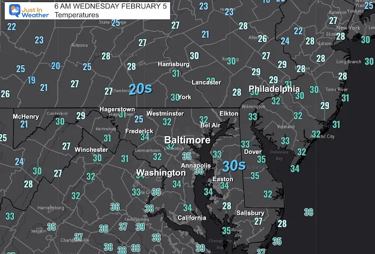
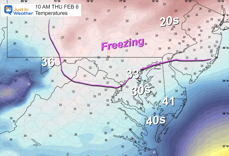
Morning Temperatures
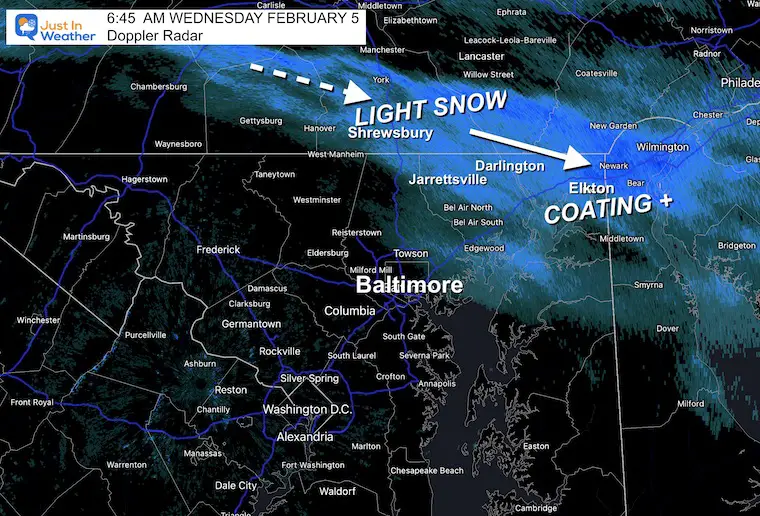
Doppler Radar at 6:45 AM
This narrow band of snow may drop a coating into parts of Harford and Cecil County in Maryland.
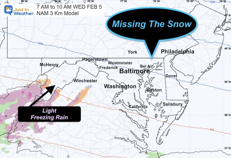
Model Comparison
A nowcasting technique is to compare and see which model handles the current setup best.
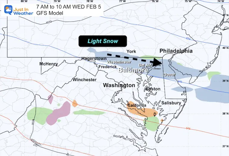
The high-resolution NAM missed this snow, but the GFS actually showed it best. That is why I continue to rely on that model in this situation.
NAM
GFS
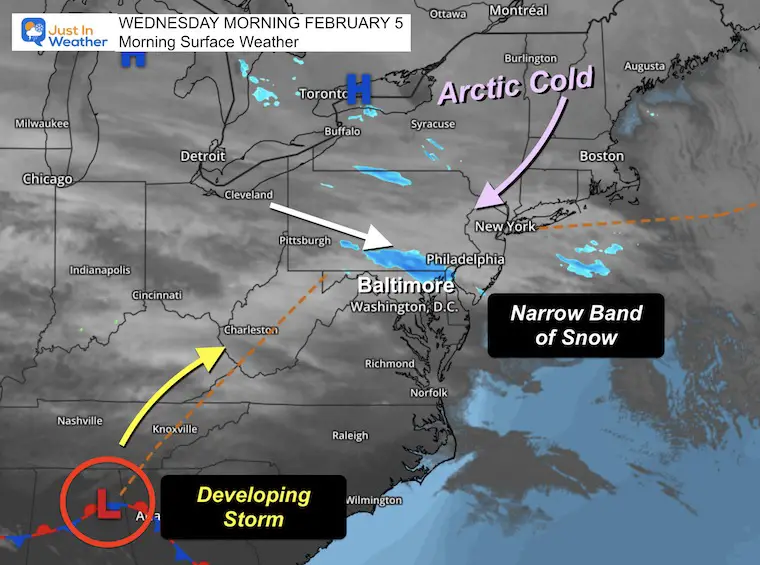
Morning Surface Weather
The Arctic air has arrived in New England and is sending the cold air our way.
A thin band of snow has formed over Southern Pennsylvania to Northeastern Maryland.
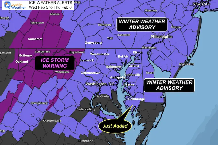
Ice Storm Alerts
The Winter Weather Advisory has been:
- EXTENDED to 10 AM in Central Maryland.
- EXPANDED to Dorchester County, Maryland.
Radar Simulation 10 AM Wed to 1 PM Thu
GFS Model has handled this best so far…
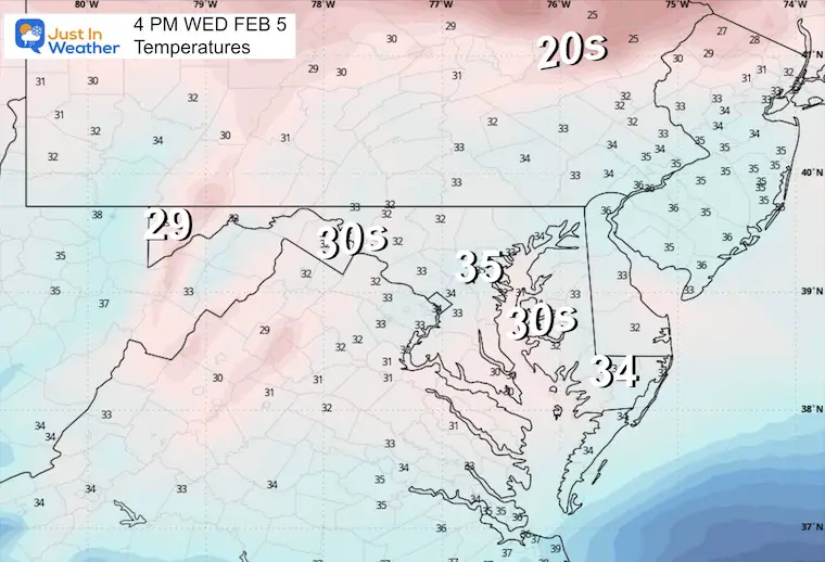
Afternoon Snapshot
Temperatures
Overnight
1 AM
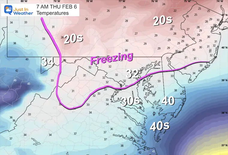
7 AM
Daybreak: The thaw will be slow. Models often have a tough time moving the warm air in. The thickness of ice will also determine how long it takes to melt after temperatures warm.
Temperatures
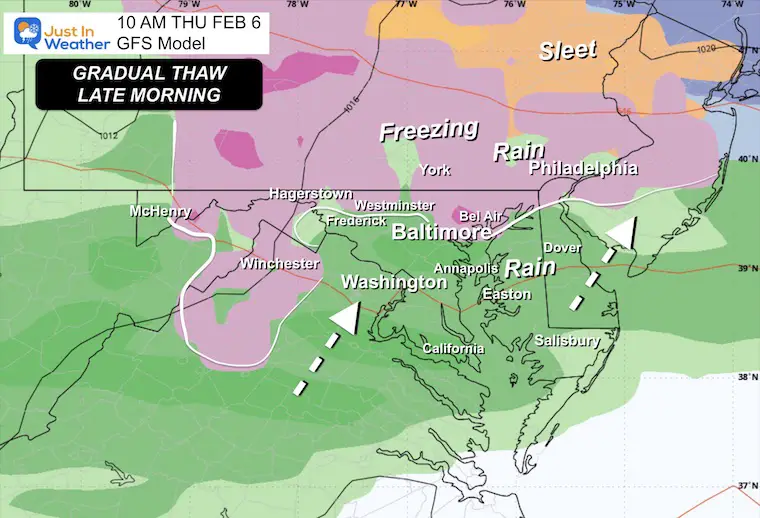
10 AM
The thaw will expand late morning to early afternoon for the colder inland areas.
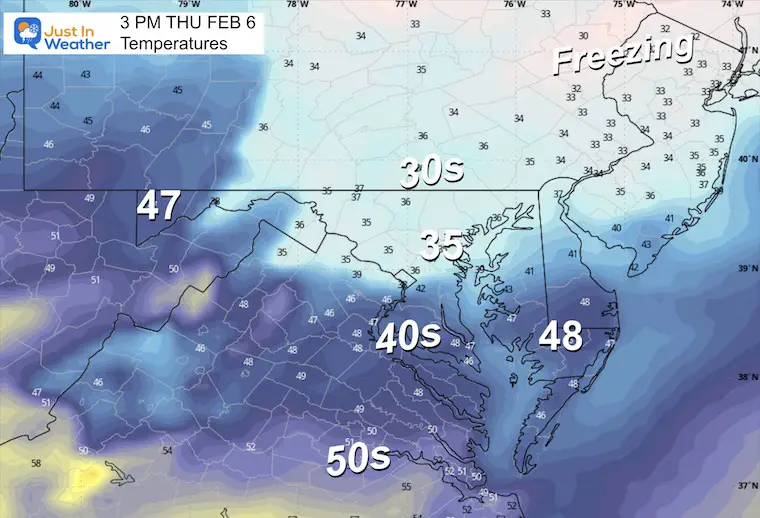
Temperatures
Thursday Afternoon Temperatures
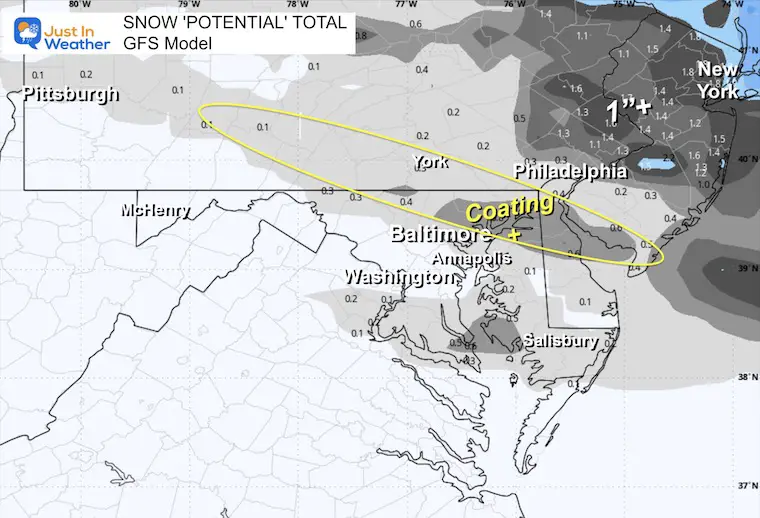
Winter Precipitation POTENTIAL Forecasts
GFS Snow
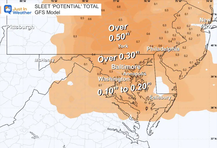
GFS Sleet
There may be heavy sleet with up to 1 inch BEFORE the freezing rain develops.
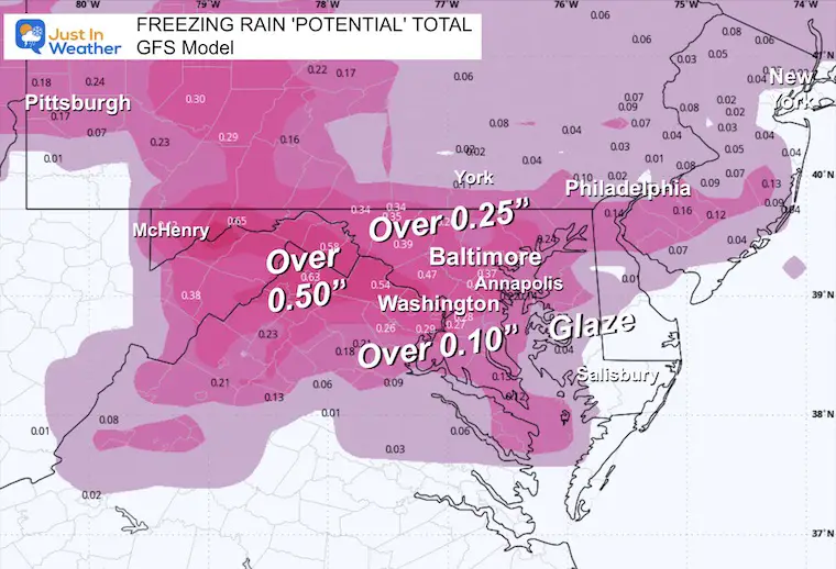
GFS Freezing Rain
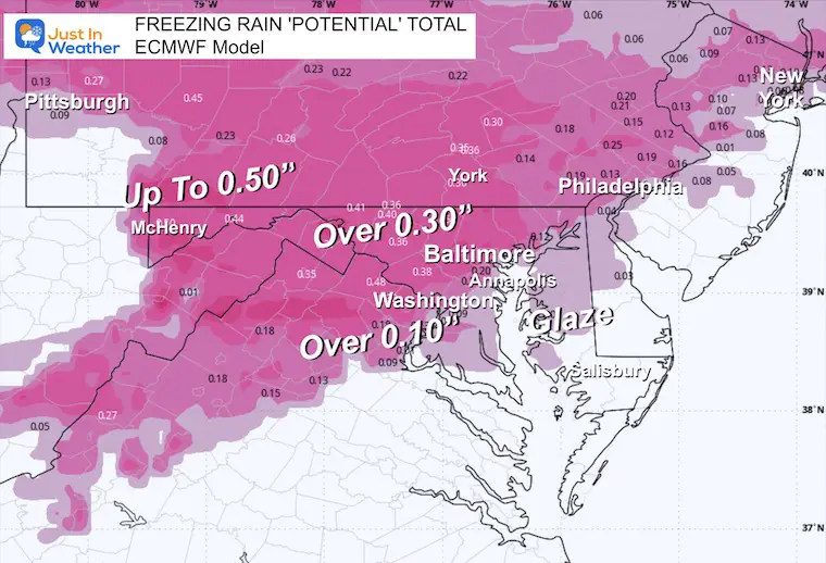
ECMWF Freezing Rain
Winter Precipitation
The wintry mix of sleet or freezing rain depends on the thickness of warm air in the middle of the atmosphere. An inversion is a layer of warm air sandwiched between colder clouds and colder ground. Snow may form in the clouds, fall and melt, then have a chance to freeze again on the way down.
Sleet = Melted snow refreezes to ice pellets on the way down.
Freezing Rain = Melted snow can not refreeze in time, but will on contact with the ground. It falls like rain, then ices on the surface of anything it touches.
Active Pattern On Repeat:
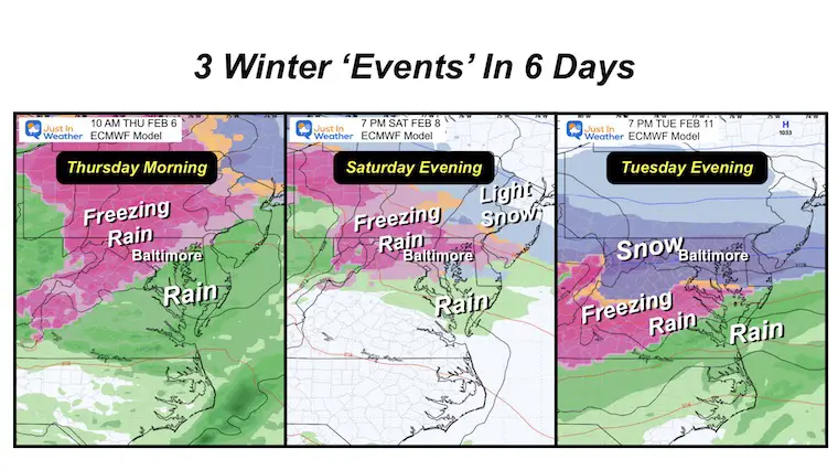
Both models show another round of Wintry Mix To Freezing Rain on Saturday, ending with rain on Sunday morning.
Next week will try to work on colder air and bring us snow.
GFS Forecast Saturday through Tuesday
ECMWF Model Snapshots
7 Day Forecast
A break from the ice later Thursday and Friday.
Atmospheric Memory: The storm pattern will try to repeat again this weekend with more freezing rain Saturday evening.
The pattern remains active with more wintry weather next week

Subscribe for eMail Alerts
La Nina Advisory January 2025
Full Report

MY WINTER OUTLOOK
My Winter Outlook Report

ALSO SEE
Recent Snow Reports
SNOW REPORTS THIS SEASON
Click on the maps for that full report.
January 19 Snow Report

January 11 Snow Report

January 6 Snow Report

Previous Snow

FITF Gear on Sale

In Case You Missed This
The Faith In The Flakes Dec 5 Origin Story

Please share your thoughts and best weather pics/videos, or just keep in touch via social media.
SCHEDULE A WEATHER BASED STEM ASSEMBLY
Severe Weather: Storm Smart October and next spring Winter Weather FITF (Faith in the Flakes): November To March Click to see more and send a request for your school.

THANK YOU:
Baltimore Magazine Readers Choice Best Of Baltimore
Maryland Trek 11 Day 7 Completed Sat August 10
We raised OVER $104,000 for Just In Power Kids – AND Still Collecting More
The annual event: Hiking and biking 329 miles in 7 days between The Summit of Wisp to Ocean City.
Each day, we honor a kid and their family’s cancer journey.
Fundraising is for Just In Power Kids: Funding Free Holistic Programs. I never have and never will take a penny. It is all for our nonprofit to operate.
Click here or the image to donate:

RESTATING MY MESSAGE ABOUT DYSLEXIA
I am aware there are some spelling and grammar typos and occasional other glitches. I take responsibility for my mistakes and even the computer glitches I may miss. I have made a few public statements over the years, but if you are new here, you may have missed it: I have dyslexia and found out during my second year at Cornell University. It didn’t stop me from getting my meteorology degree and being the first to get the AMS CBM in the Baltimore/Washington region. One of my professors told me that I had made it that far without knowing and to not let it be a crutch going forward. That was Mark Wysocki, and he was absolutely correct! I do miss my mistakes in my own proofreading. The autocorrect spell check on my computer sometimes does an injustice to make it worse. I also can make mistakes in forecasting. No one is perfect at predicting the future. All of the maps and information are accurate. The ‘wordy’ stuff can get sticky. There has been no editor who can check my work while writing and to have it ready to send out in a newsworthy timeline. Barbara Werner is a member of the web team that helps me maintain this site. She has taken it upon herself to edit typos when she is available. That could be AFTER you read this. I accept this and perhaps proves what you read is really from me… It’s part of my charm. #FITF


