Monday Night, February 3, 2025
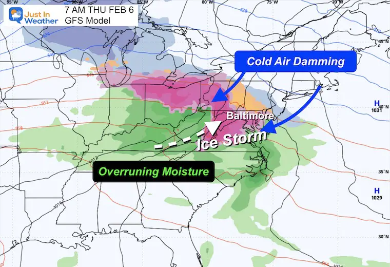
I think it’s time to call this what it is. We will have an ice storm. It will not be the worst, but it will be the most impactful in a few years. I have high confidence that Wednesday night into Thursday morning, cold air damming with an overrunning event will lead to extending sleet and freezing rain. Basically, the cold air will stay close to the ground, while a storm brings water moisture at cloud level. I am very confident that it will lead it travel problems and likely impact schools on Thursday morning.
The details are coming into better focus. In all reality, there is less stress from a forecasting point with an ice storm over a snowstorm because it’s less likely to stick a ruler in the ice. The thing that is most important will be the timing for the start and the end. As for the totals, there may be areas over 1/4 inch, which can break some branches and lead to some power outages. Two things to keep in mind with an ice storm:
- Once we get into a cold air dam with ice, it is very difficult for models to predict when it will lift and thaw.
- Even when the temperatures rise above 32F, it takes time for the ice to thaw, so it doesn’t end quickly.
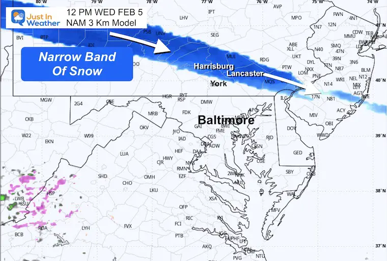
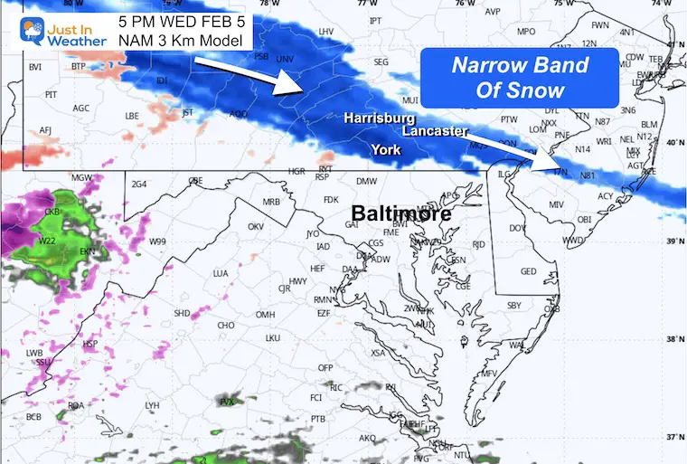
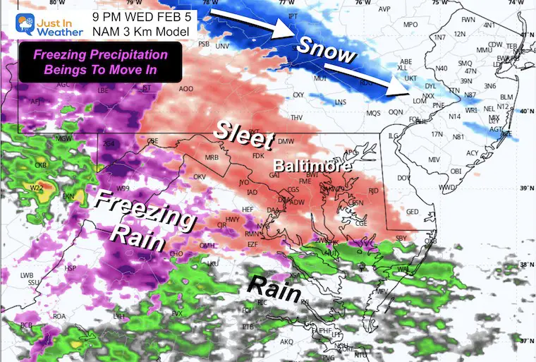
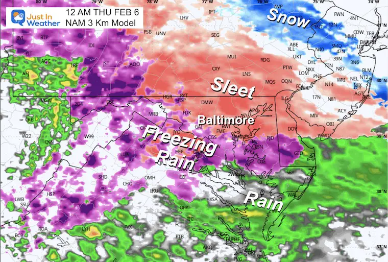
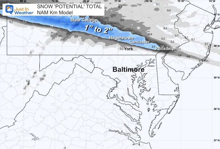
Wednesday NAM 3 Km Model
This high resolution simply holds onto the overrunning band of snow in parts of Pennsylvania. There may be a stripe affecting Harrisburg, York, Lancaster, and even Philadelphia with a coating to a few inches.
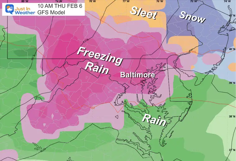
The freezing rain moving in from Virginia and Maryland will arrive after sunset.
I trust this model is close to within 1 to 2 hours. Note, that this model is the one that accurately showed the sleet and freezing rain Sunday night.
Snapshots
Noon
5 PM – Evening
9 PM – Night
12 AM Midnight
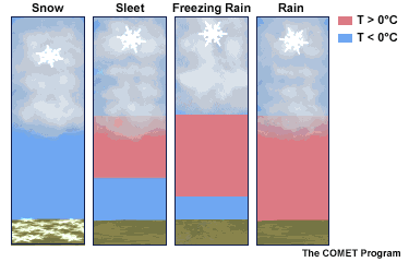
Winter Precipitation
The wintry mix of sleet or freezing rain depends on the thickness of warm air in the middle of the atmosphere. An inversion is a layer of warm air sandwiched between colder clouds and colder ground. Snow may form in the clouds, then fall and melt, then have a chance to freeze again on the way down.
Sleet = Melted snow refreezes to ice pellets on the way down.
Freezing Rain = Melted snow can not refreeze in time, but will on contact with the ground. It falls like rain, then ices on the surface of anything it touches.
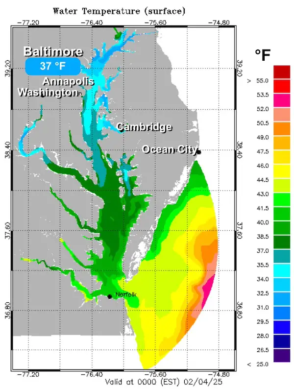
Colder Than Average Water
The latest on the Chesapeake Bay shows that it will have little impact on the cold air that will develop across the region. This is important because if this was earlier in winter, the Bay areas would be more protected by warmer water.
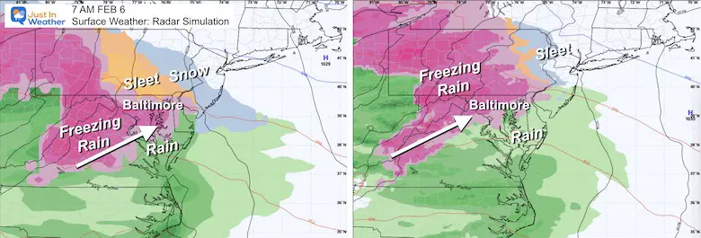
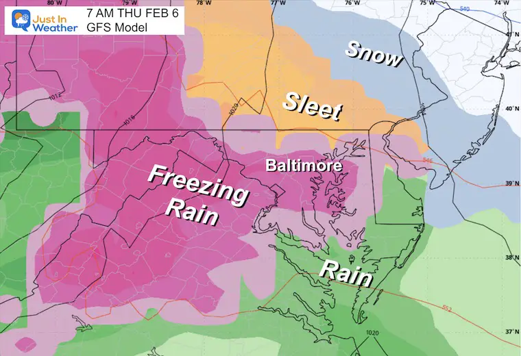
Thursday Morning Ice Comparison
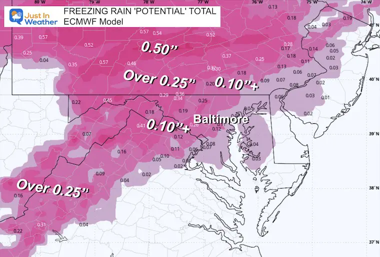
Both the GFS and ECMWF Models show us in the ice at daybreak. I wanted to contrast these to show the agreement. I am still sticking with the GFS Model since it was the first to show this and the most consistent as well. The ECWMF Model has been playing catch-up.
GFS Model Thursday Morning
Storm Animation: 1 AM Thu to 7 AM Fri
Thursday Sunrise
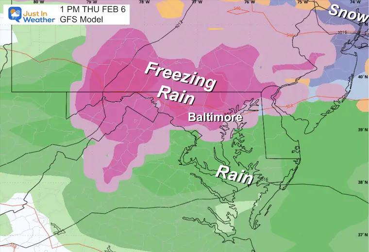
The GFS holds the cold and ice longer across metro areas in central Maryland. The Euro, on the other hand, lifts the warmer air north of Baltimore by daybreak. Again, this may be too soon.
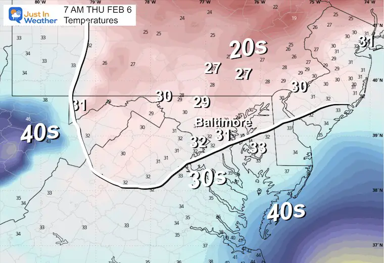
Temperatures
Late Morning
Early Afternoon
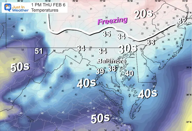
Temperatures
The air will be warming near and above freezing. This is an example of the model struggling to depict when the thaw will advance north.
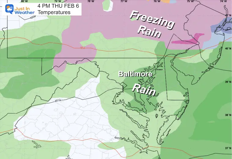
Late Afternoon:
We should be in the thaw by then.
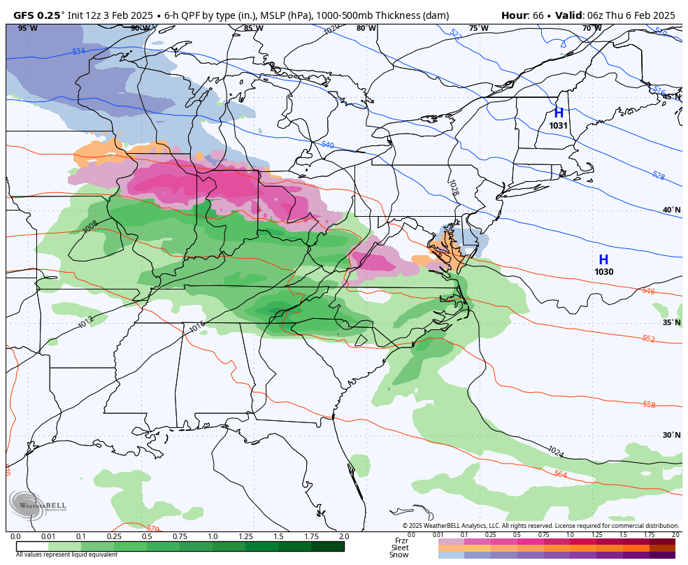
Precipitation Breakdown
Winter Precipitation POTENTIAL Forecasts
NAM Snow
This is a low confidence and low impact part. The High-Resolution NAM is holding on to the overrunning snow in Southern PA. Even though the GFS lost this, I still buy into it…
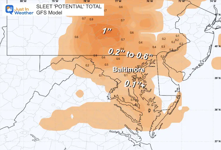
GFS Sleet
Like we had Sunday night, this is a bear, and with freezing rain to follow, it will add to the ice thickness on the ground.
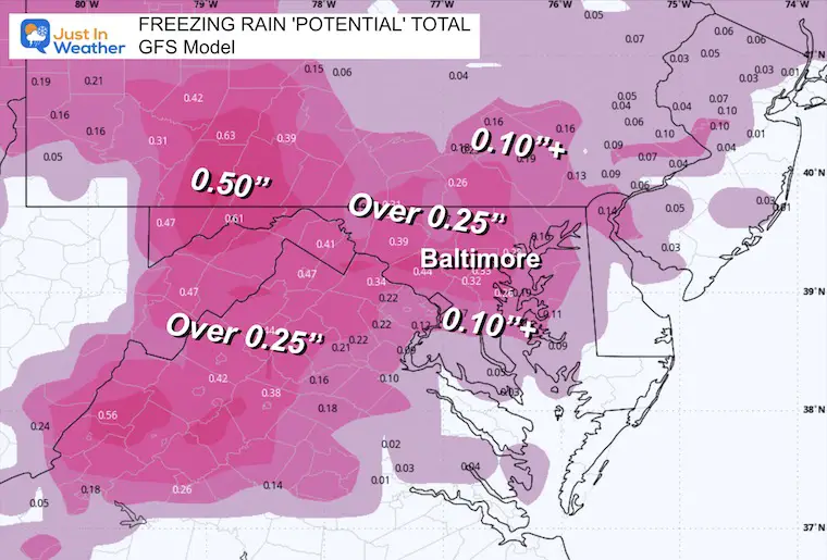
GFS Freezing Rain
This is the COLDER SOLUTION, showing a more widespread and heavier impact.
ECMWF Freezing Rain
This solution has less total ice but still enough to be impactful.
Which to believe?
I continue to lean towards the GFS to hold the cold longer based off:
- Cold ground
- Temps today (Sunday) verified colder than forecast
- Colder Water
- Models often struggle with Cold Air Damming setups.
- As for the totals… I do see the GFS possibly overdoing the precipitation totals. It is possible we end up with total ice as the average between the GFS and ECMWF. Anything over 0.1” will be a problem and take extra hours to melt after the thaw.
Final Thoughts:
A glaze of ice = Travel Problems.
0.10” Ice = Moderate Icing, And Some Branches May Fall
0.25” to 0.50”+ Ice = Trees and Power Lines start to have more breaks. This would be a widespread disruption.
Thicker ice also means a longer time to thaw. So temps could warm, but a few additional hours would be needed for melting to allow for safe travel.
In short, this is the worst weather to travel in, you can’t play in it, and there is a high chance of schools being impacted on Thursday.
Subscribe for eMail Alerts
La Nina Advisory January 2025
Full Report

MY WINTER OUTLOOK
My Winter Outlook Report

ALSO SEE
Recent Snow Reports
SNOW REPORTS THIS SEASON
Click on the maps for that full report.
January 19 Snow Report

January 11 Snow Report

January 6 Snow Report

Previous Snow

FITF Gear on Sale

In Case You Missed This
The Faith In The Flakes Dec 5 Origin Story

Please share your thoughts and best weather pics/videos, or just keep in touch via social media.
SCHEDULE A WEATHER BASED STEM ASSEMBLY
Severe Weather: Storm Smart October and next spring Winter Weather FITF (Faith in the Flakes): November To March Click to see more and send a request for your school.

THANK YOU:
Baltimore Magazine Readers Choice Best Of Baltimore
Maryland Trek 11 Day 7 Completed Sat August 10
We raised OVER $104,000 for Just In Power Kids – AND Still Collecting More
The annual event: Hiking and biking 329 miles in 7 days between The Summit of Wisp to Ocean City.
Each day, we honor a kid and their family’s cancer journey.
Fundraising is for Just In Power Kids: Funding Free Holistic Programs. I never have and never will take a penny. It is all for our nonprofit to operate.
Click here or the image to donate:

RESTATING MY MESSAGE ABOUT DYSLEXIA
I am aware there are some spelling and grammar typos and occasional other glitches. I take responsibility for my mistakes and even the computer glitches I may miss. I have made a few public statements over the years, but if you are new here, you may have missed it: I have dyslexia and found out during my second year at Cornell University. It didn’t stop me from getting my meteorology degree and being the first to get the AMS CBM in the Baltimore/Washington region. One of my professors told me that I had made it that far without knowing and to not let it be a crutch going forward. That was Mark Wysocki, and he was absolutely correct! I do miss my mistakes in my own proofreading. The autocorrect spell check on my computer sometimes does an injustice to make it worse. I also can make mistakes in forecasting. No one is perfect at predicting the future. All of the maps and information are accurate. The ‘wordy’ stuff can get sticky. There has been no editor who can check my work while writing and to have it ready to send out in a newsworthy timeline. Barbara Werner is a member of the web team that helps me maintain this site. She has taken it upon herself to edit typos when she is available. That could be AFTER you read this. I accept this and perhaps proves what you read is really from me… It’s part of my charm. #FITF


