February 3 2025
Monday Morning Report
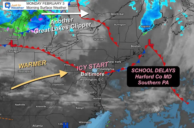
Light sleet and freezing rain last night left a layer of ice on the roads across parts of Northern Maryland and Southern Pennsylvania. Temps below freezing this morning will bounce back to the 50s later, so we will thaw out.
We can expect a warm-up for two days; then a Cold Air Damming event may lead to an ice storm Wednesday into Thursday. Also the expected Polar Vortex Split is still expected to begin after another weekend ice event and really affect us in the middle of this month.
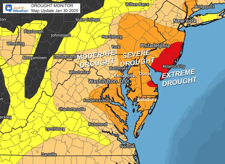
DROUGHT UPDATE
Rainfall Deficit at BWI
Ending 2024 = -8.00, since Jan 1 = -1.69
So we are down -9.69″, including last year!
Morning Surface Weather
A warm front will swing through today, but we first need to thaw. That band of light sleet and freezing rain and ice, resulting in school delays across parts of Maryland and Southern Pennsylvania.
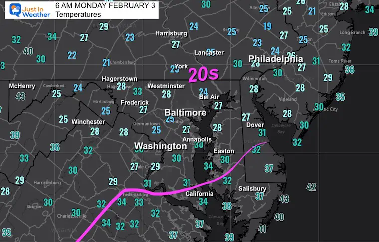
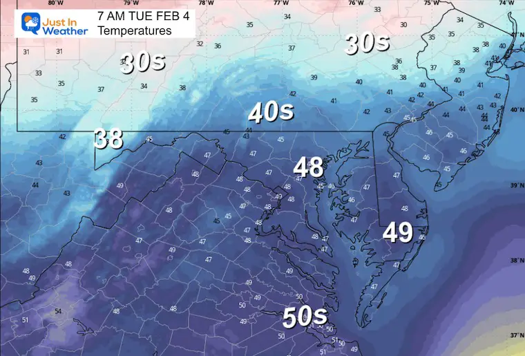
Morning Temperatures
Many areas dropped below freezing, and there may be icy spots outside of the school-delayed areas.
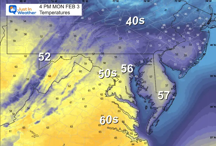
Afternoon Temperatures
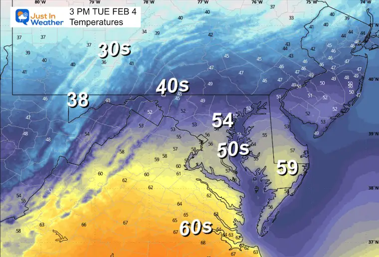
We will get into the 50s.
CLIMATE DATA: Baltimore
TODAY February 3
Sunrise at 7:11 AM
Sunset at 5:30 PM
Normal Low in Baltimore: 25ºF
Record 4ºF in 1961
Normal High in Baltimore: 44ºF
Record 67ºF 2020
Baltimore Seasonal Snow
8.9”
TUESDAY WEATHER
Morning Temperatures
Afternoon Temperatures
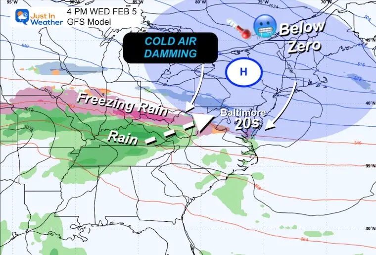
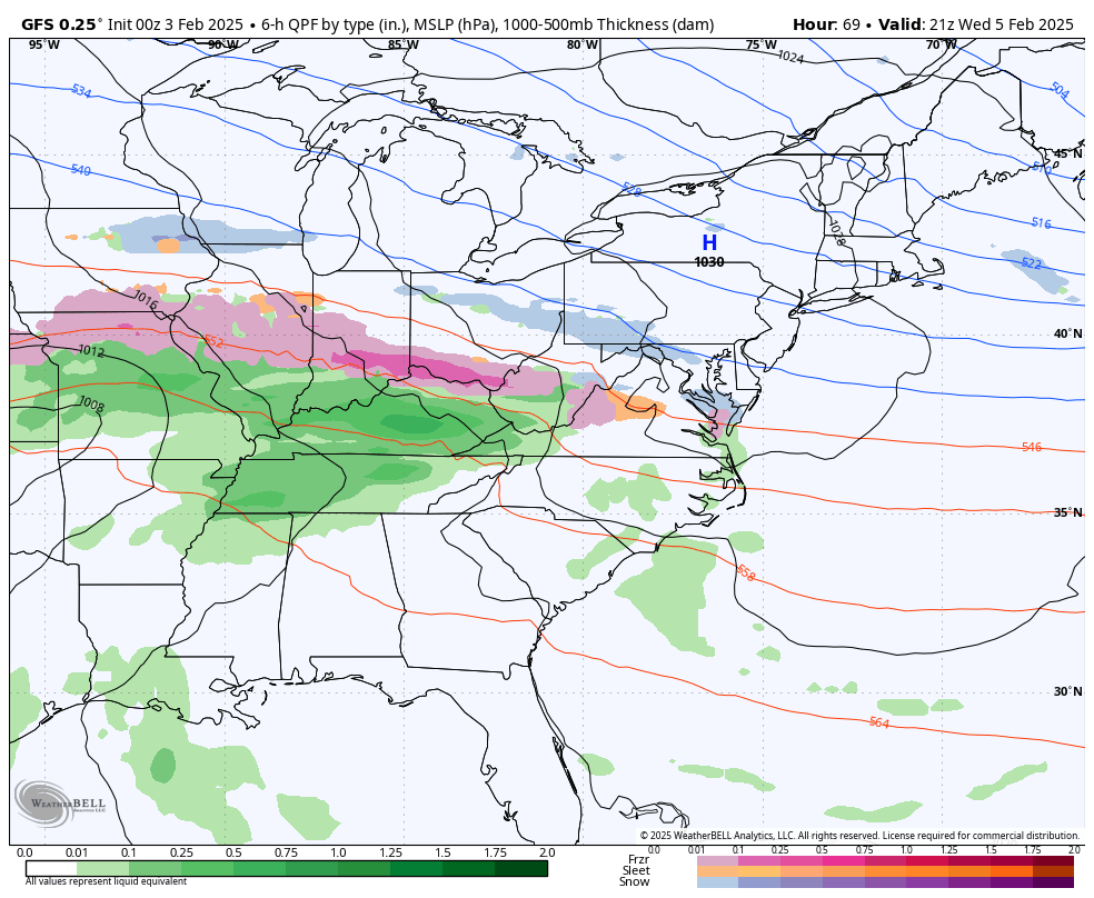
Mid Week Ice Storm?
The concern is an Arctic Air Mass in Eastern Canada that will have temperatures well below zero… spreading cold air along the surface into the Mid-Atlantic. We would get this by Wednesday morning… just as a new storm spreads warmer air at cloud level.
The overnight models still suggest a light, wintry mix on Wednesday. My focus is more on the wide area of freezing rain and a potential ice storm Wednesday night into Thursday morning.
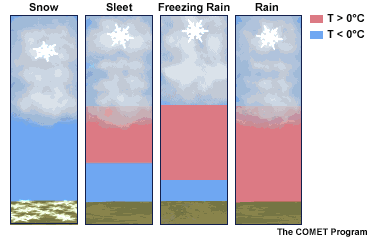
Winter Precipitation
The wintry mix of sleet or freezing rain depends on the thickness of warm air in the middle of the atmosphere. An inversion is a layer of warm air sandwiched between colder clouds and colder ground. Snow may form in the clouds, then fall and melt, then have a chance to freeze again on the way down.
Sleet = Melted snow, then can refreeze to ice pellets on the way down.
Freezing Rain = Melted snow that can not refreeze in time, but will on contact with the ground. It falls like rain, then ices on the surface of anything it touches.
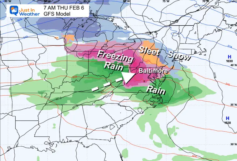
Wednesday Afternoon Set Up
High Pressure in New England will help send very cold air along the surface through Maryland and Northern Virginia. The next precipitation event will force rain to ride over the cold air. This is where the icy mix mill will develop. It may start with a thin band of snow.
Storm Animation:
GFS Model: 4 PM Wed to 7 PM Thu
Close Up
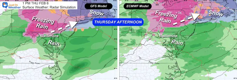
Thursday Morning
Concern for an ice storm! A few hours of Freezing Rain may be very troublesome.
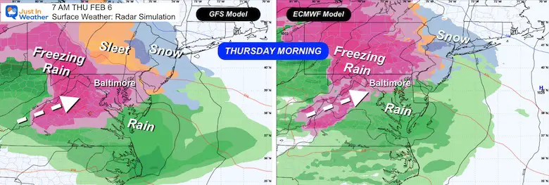
Compare/Contrast
Both the GFS and ECWMF have ice across the region. The ECWMF Model plots it farther north.
Sunrise
Thursday Afternoon
We will thaw in the afternoon. Historically, models do a poor job with ice and bring the warm air in too fast…
Also: Even after temps rise, it will take hours for the ice to melt.
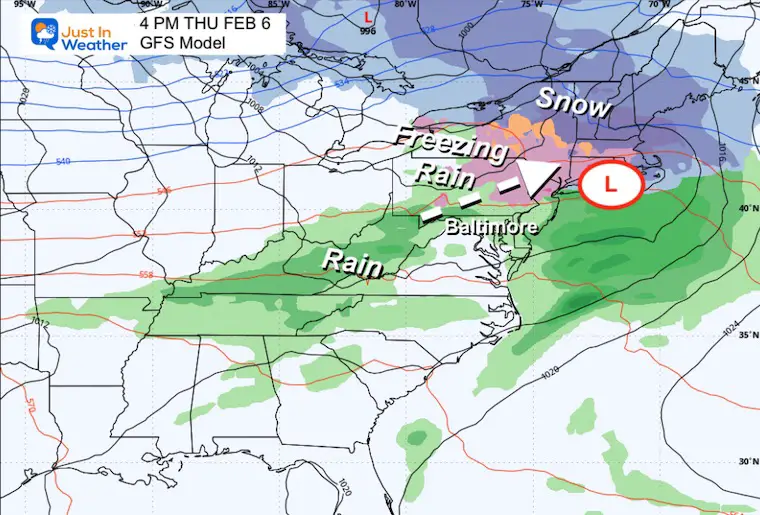
Compare/Contrast
Both models have us thawing out in the afternoon.
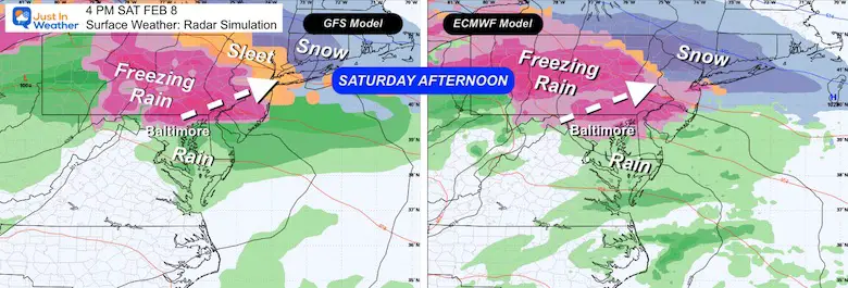
Weekend Repeat:
Both models show another round of Freezing Rain on Saturday
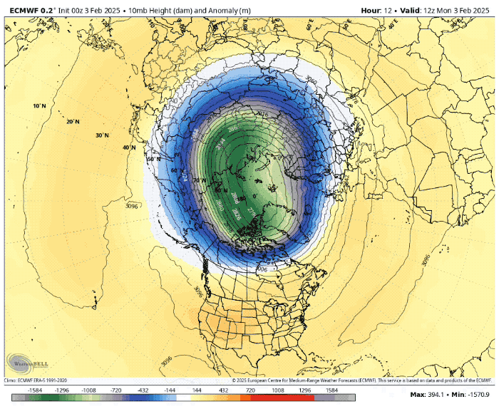
Polar Vortex Feb 3 to Feb 17
Currently a strong and high circulation, locking the cold air up to the north. This is forecast to split into two pieces or sister vortices over the next two weeks. The stronger, larger one drops south into Canada and affects the Eastern US by mid-month…
Stratosphere: This map is at the 10 mb level, roughly 50,000 Ft in altitude.
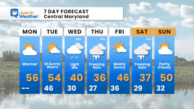
7 Day Forecast
Widely variable temps and weather:
After this icy morning, we get two afternoons in the 50s.
Wednesday: Return of the colder air with a light mix possible. The focus will be the freezing rain Wednesday night into Thursday morning.
Atmospheric Memory: The storm pattern will try to repeat again this weekend with more freezing rain.
Subscribe for eMail Alerts
La Nina Advisory January 2025
Full Report

MY WINTER OUTLOOK
My Winter Outlook Report

ALSO SEE
Recent Snow Reports
SNOW REPORTS THIS SEASON
Click on the maps for that full report.
January 19 Snow Report

January 11 Snow Report

January 6 Snow Report

Previous Snow

FITF Gear on Sale

In Case You Missed This
The Faith In The Flakes Dec 5 Origin Story

Please share your thoughts and best weather pics/videos, or just keep in touch via social media.
SCHEDULE A WEATHER BASED STEM ASSEMBLY
Severe Weather: Storm Smart October and next spring Winter Weather FITF (Faith in the Flakes): November To March Click to see more and send a request for your school.

THANK YOU:
Baltimore Magazine Readers Choice Best Of Baltimore
Maryland Trek 11 Day 7 Completed Sat August 10
We raised OVER $104,000 for Just In Power Kids – AND Still Collecting More
The annual event: Hiking and biking 329 miles in 7 days between The Summit of Wisp to Ocean City.
Each day, we honor a kid and their family’s cancer journey.
Fundraising is for Just In Power Kids: Funding Free Holistic Programs. I never have and never will take a penny. It is all for our nonprofit to operate.
Click here or the image to donate:

RESTATING MY MESSAGE ABOUT DYSLEXIA
I am aware there are some spelling and grammar typos and occasional other glitches. I take responsibility for my mistakes and even the computer glitches I may miss. I have made a few public statements over the years, but if you are new here, you may have missed it: I have dyslexia and found out during my second year at Cornell University. It didn’t stop me from getting my meteorology degree and being the first to get the AMS CBM in the Baltimore/Washington region. One of my professors told me that I had made it that far without knowing and to not let it be a crutch going forward. That was Mark Wysocki, and he was absolutely correct! I do miss my mistakes in my own proofreading. The autocorrect spell check on my computer sometimes does an injustice to make it worse. I also can make mistakes in forecasting. No one is perfect at predicting the future. All of the maps and information are accurate. The ‘wordy’ stuff can get sticky. There has been no editor who can check my work while writing and to have it ready to send out in a newsworthy timeline. Barbara Werner is a member of the web team that helps me maintain this site. She has taken it upon herself to edit typos when she is available. That could be AFTER you read this. I accept this and perhaps proves what you read is really from me… It’s part of my charm. #FITF


