


New Years Day Snow Squall And Falling Temps Entering 2026
Wednesday, December 31 New Year's Eve Update Closing out the year, we have a strong clipper to our north. This is going to drag a distinct push of arctic air…
January 26, 2025
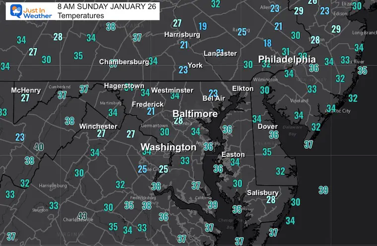
Sunday Morning Report
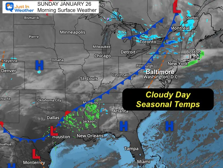
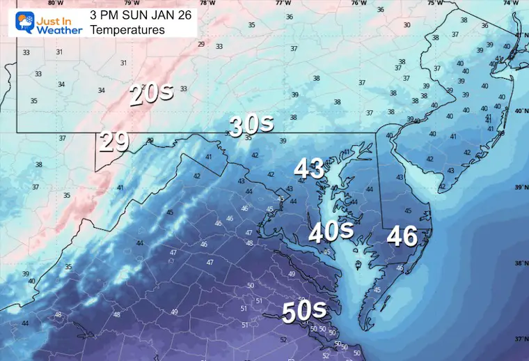
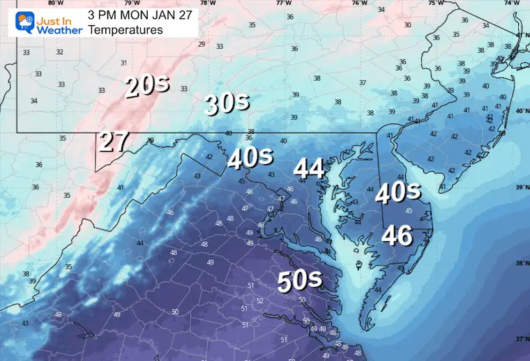
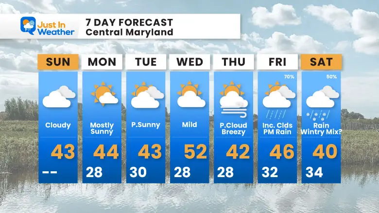
There will be more clouds today as a weak frontal boundary is moving through. Temperatures start in much of central Maryland above freezing, which is warmer than most afternoons during the week.
The weather pattern will relax for the week as temperatures remain close to seasonal averages, and one or two warmer days are expected.
The next storm may arrive by the weekend with rain. A chance for colder air to try and make a return to end with a wintry mix. More on that below.
I took a day off for the Maryland State Police Polar Bear Super Plunge. Yes, there was ice on the bay and this may have provided additional challenges. But there were safety measures in place, and the event went off as scheduled.
If you missed my updates on my Facebook page, here are a few highlights.
Let’s start with an amazing morning view from Saturday. This was as the ice was rebuilding at Sandy Point State Park, and the rising crescent moon was reflected on it framed by the Bay Bridge.
Thank you for all of your support in helping my team reach our goal.
Sunrise at 7:18 AM
Sunset at 5:21 PM
Normal Low in Baltimore: 25ºF
Record 2ºF in 1961
Normal High in Baltimore: 43ºF
Record 79ºF 1950
Baltimore Seasonal Snow
8.9”
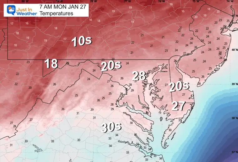
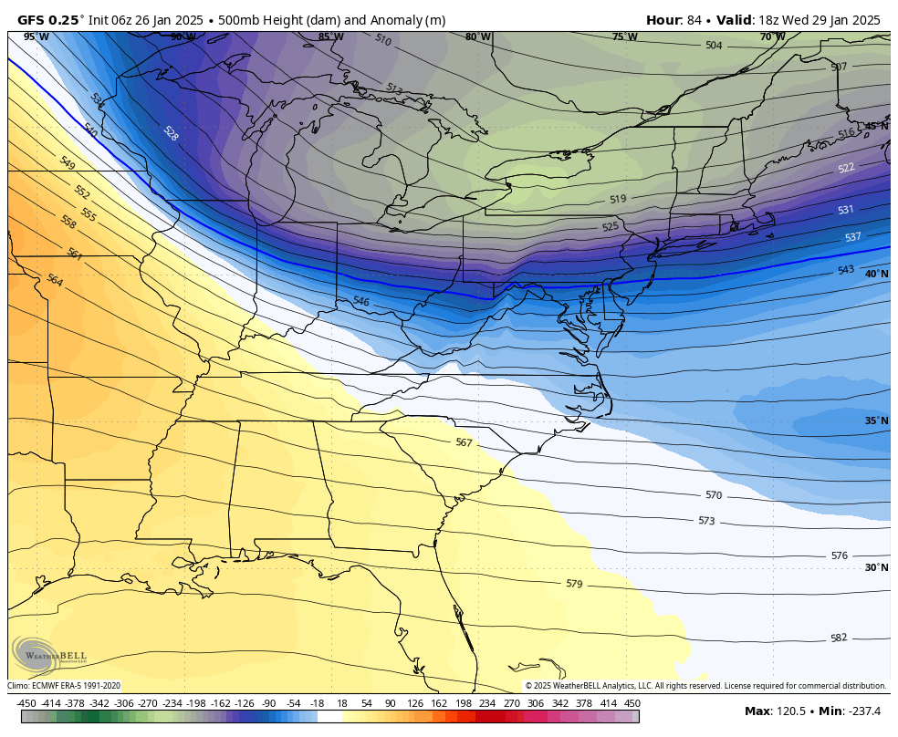
The cold air swings north and moves away.. allowing a ridge of high pressure to build a push of mild air… ahead of the next storm.
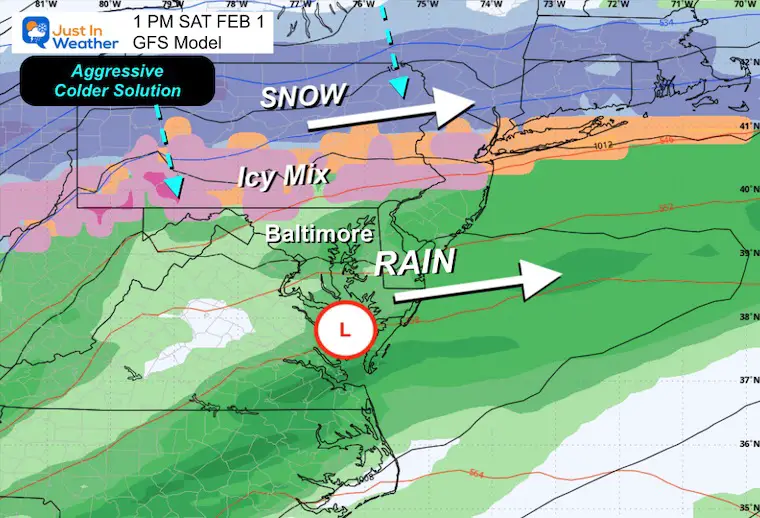
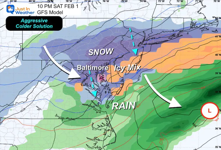
This is the GFS Solution, which is the most aggressive with both the rainfall and end with colder air that could bring a wintry mix and snow to end the storm.
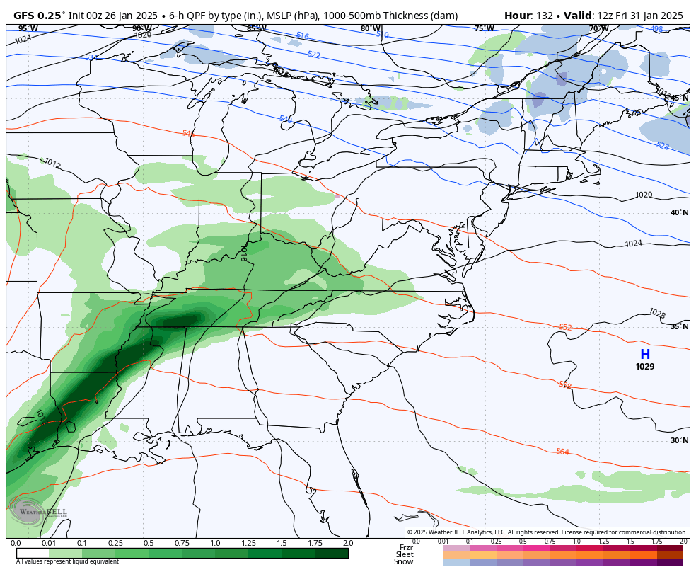
According to the GFS model, rain would move in to end the work week.
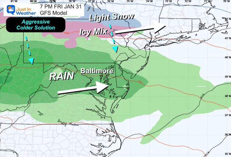
This more aggressive solution has the return of arctic air pushing a wintry mix and snow SOUTHWARD from New York and PA.
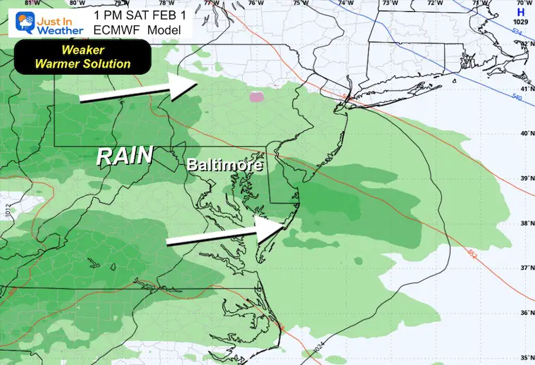
This is the same timeframe as above but with a weaker and warmer solution. If this plays out, we will only get light rain and remain near seasonal temperatures.
This more aggressive GFS model tried to develop a stronger Low Pressure that pushes the cold air into Maryland and ends with snow.
Note: I am not sold on that GFS solution, but it did a better job with than the European Model with the last storm. I need show you both options AND NOT lock into either one yet. So no promises for either and the odds remain 50%.
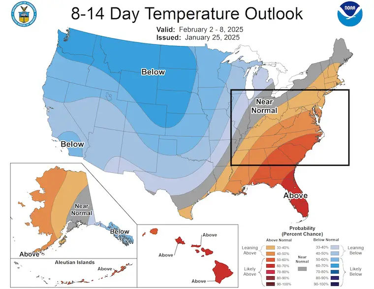
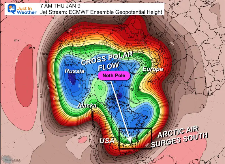
The surge of milder temps for the Eastern US while the cold air shifts to dominate the Western two-thirds.
Temperatures back to near normal for most of the week. The warmest day should be Wednesday, then we watch next weekend for two things: The next storm with rain and MAYBE a wintry mix to end… but that is the wild card.
Sign up and be the first to know!
Click on the maps for that full report.


Sign up and be the first to know!
If you missed it, here is my detailed report from December 30 about why this IS A BIG DEAL!


Severe Weather: Storm Smart October and next spring Winter Weather FITF (Faith in the Flakes): November To March Click to see more and send a request for your school.

The annual event: Hiking and biking 329 miles in 7 days between The Summit of Wisp to Ocean City.
Each day, we honor a kid and their family’s cancer journey.
Fundraising is for Just In Power Kids: Funding Free Holistic Programs. I never have and never will take a penny. It is all for our nonprofit to operate.
Click here or the image to donate:

I am aware there are some spelling and grammar typos and occasional other glitches. I take responsibility for my mistakes and even the computer glitches I may miss. I have made a few public statements over the years, but if you are new here, you may have missed it: I have dyslexia and found out during my second year at Cornell University. It didn’t stop me from getting my meteorology degree and being the first to get the AMS CBM in the Baltimore/Washington region. One of my professors told me that I had made it that far without knowing and to not let it be a crutch going forward. That was Mark Wysocki, and he was absolutely correct! I do miss my mistakes in my own proofreading. The autocorrect spell check on my computer sometimes does an injustice to make it worse. I also can make mistakes in forecasting. No one is perfect at predicting the future. All of the maps and information are accurate. The ‘wordy’ stuff can get sticky. There has been no editor who can check my work while writing and to have it ready to send out in a newsworthy timeline. Barbara Werner is a member of the web team that helps me maintain this site. She has taken it upon herself to edit typos when she is available. That could be AFTER you read this. I accept this and perhaps proves what you read is really from me… It’s part of my charm. #FITF