Sunday January 19 2025
Afternoon Update
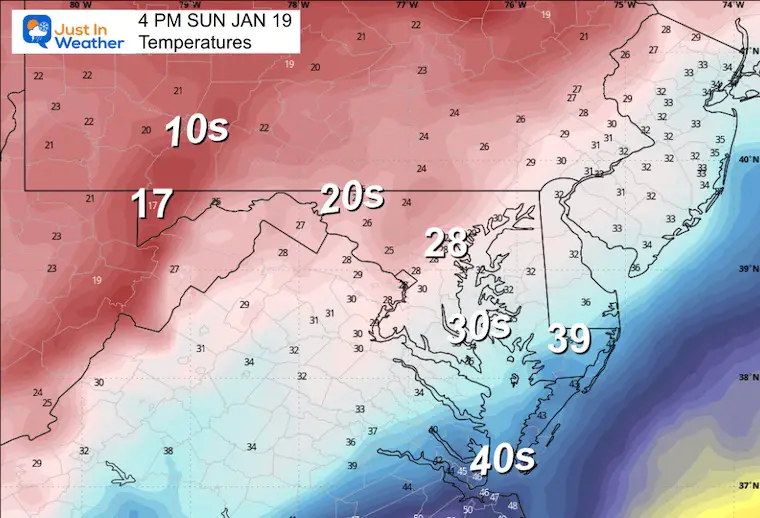
So far, the storm has behaved as expected, with one exception… Some places around the cities and I-95 have a wintry mix or just cold rain. The inland areas have had a few hours of snow, but temps have remained near or just above freezing. That is about to change. There have been a few hours of wasted flakes, but I still think the afternoon snow burst is about to develop.
I have been saying since yesterday that the peak time would be 2 PM to 6 PM and I still believe that to be on target as seen here:
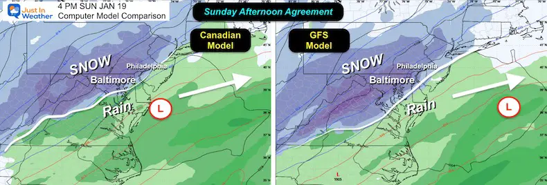
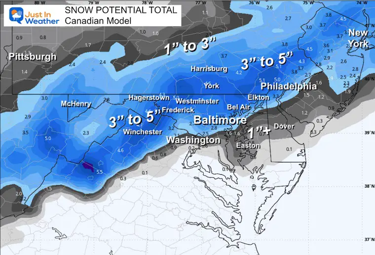
This setup does seem to match better with the Canadian Model and the short-range HRRR model rain line. But the storm is still trying to organize and develop. This process has been a little slower, but the expectation is that it will pull east and drag in the colder air with heavier precipitation this afternoon.
Model Agreement This Afternoon
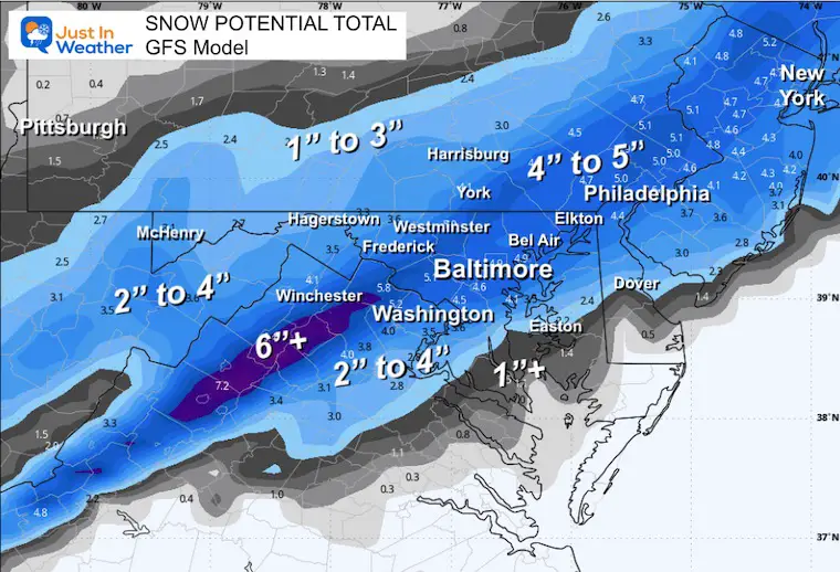
One signal is that the Canadian Model is very close to the GFS Model showing that expansion of snow this afternoon. If you recall from all the maps I showed this week, the Canadian Model was the warmest… so now that it is in line with the others, there is better confidence for metro areas getting back to the snow.
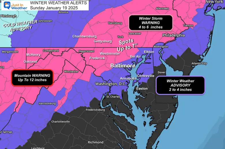
Winter Weather Alerts
Set Up At 1 PM
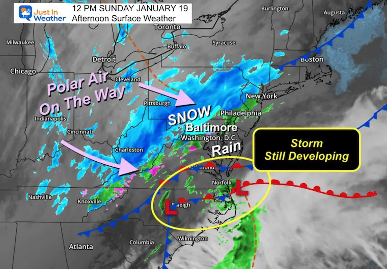
Noon Surface Weather
The surface storm looks ragged, but it is still organizing and developing. This is just taking a couple of extra hours.
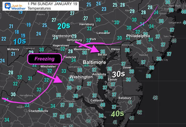
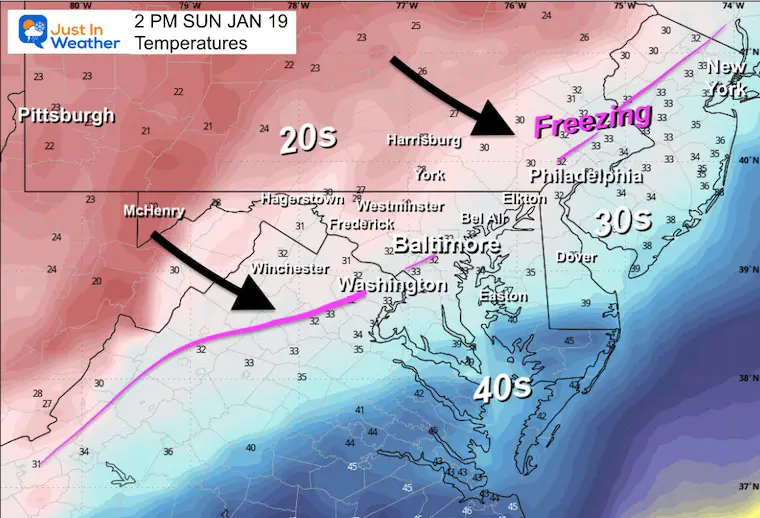
Temperatures
The freezing line has reached Hagerstown and York in PA. It is about to pass through Westminster and on the move to the east. Most of the region east of the mountains has been above freezing.
In the Winter Storm Warning Zone, there they have had snow for hours… It is about to start the process of sticking and that will expand eastward.
The Polar Air is about to pounce in as well.
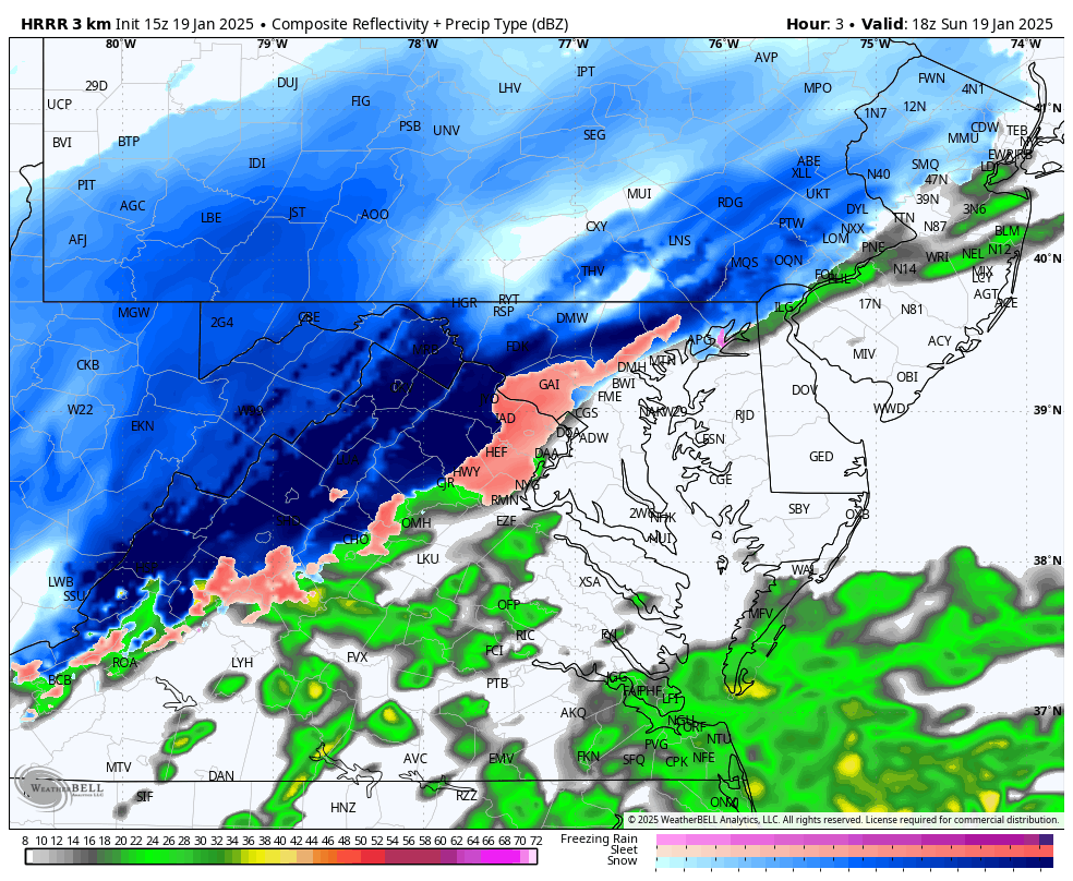
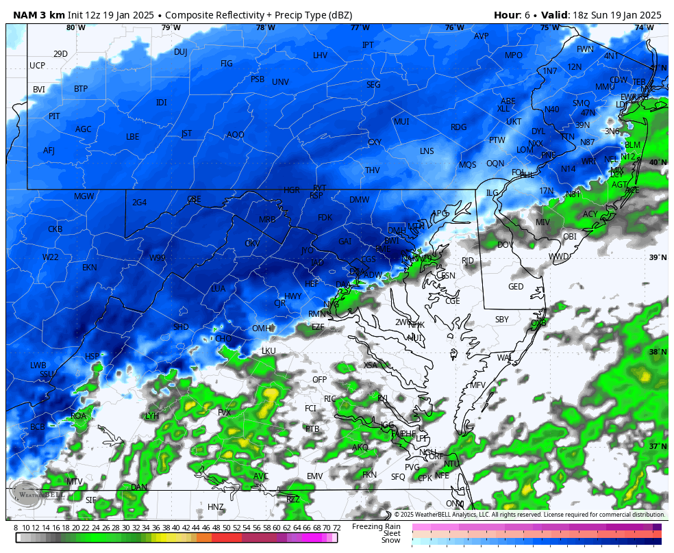
Forecast Radar Simulations
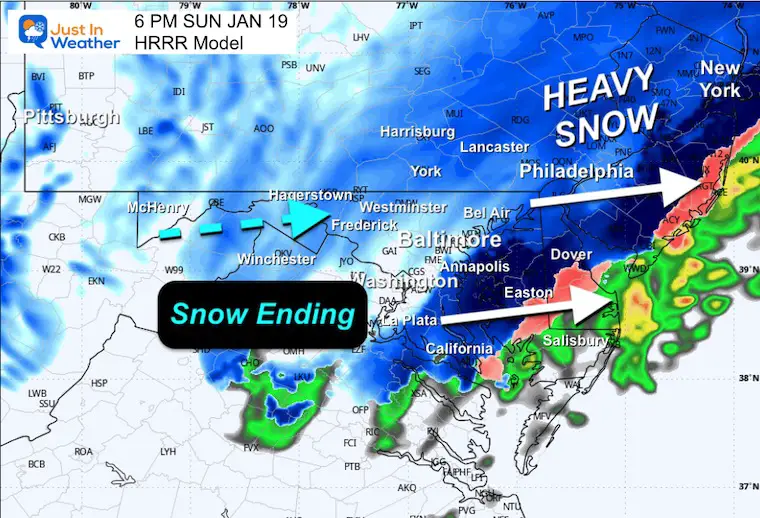
Here are the two main short-range high-resolution models. The HRRR Model is the warmer one and shows the mix of sleet and snow starting for the cities by 2 PM… Ending after 6 PM.
HRRR Animation
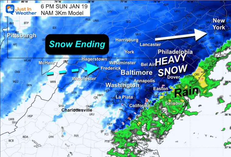
NAM 3Km Animation
This is a more robust solution with snow setting up south of I-95 by 2 PM and heavier snow lasting an extra hour or two.
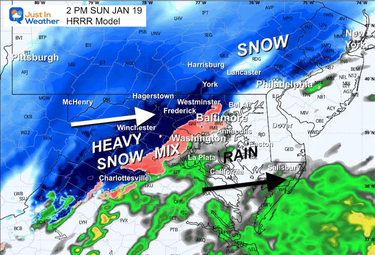
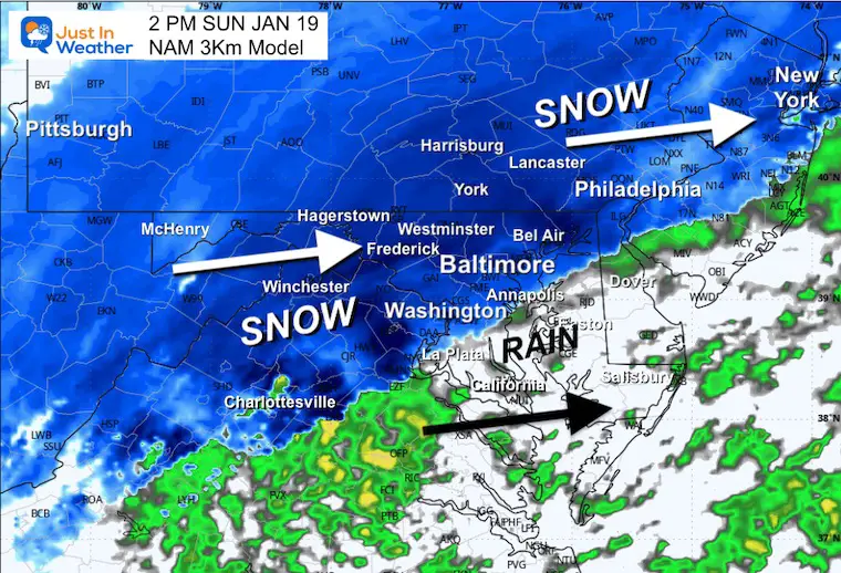
Compare Snapshots
2 PM
HRRR
NAM 3Km
Temperatures from the GFS Model
This shows the Freezing Line moving through I-95 and starting to pass through the metro areas of Washington, Baltimore, and Philadelphia.
6 PM
HRRR
NAM 3Km
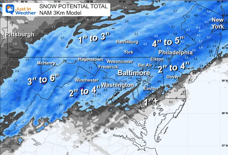
Updated Snow Forecasts
This is from this morning, after snow had already fallen in the mountains, so their totals will appear lower to only include additional snow.
NAM 3 Km
The lowest.
Canadian Model
GFS Model
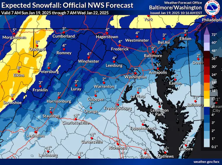
National Weather Service Update
They did drop to the lower end of the expected zone.
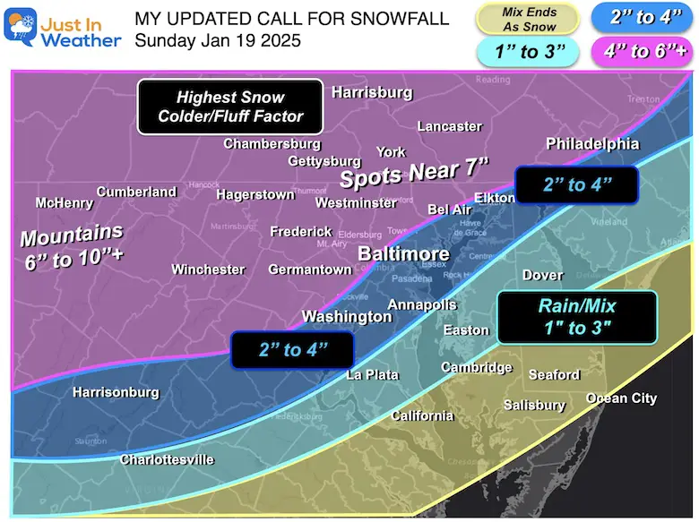
My Final Call For Snowfall
I have not changed this since yesterday. I still think we will verify in my zones, even if in the middle or lower end.
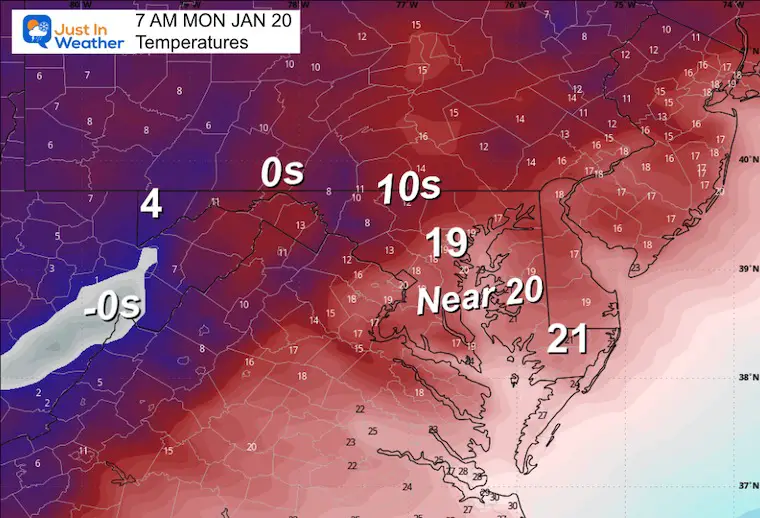
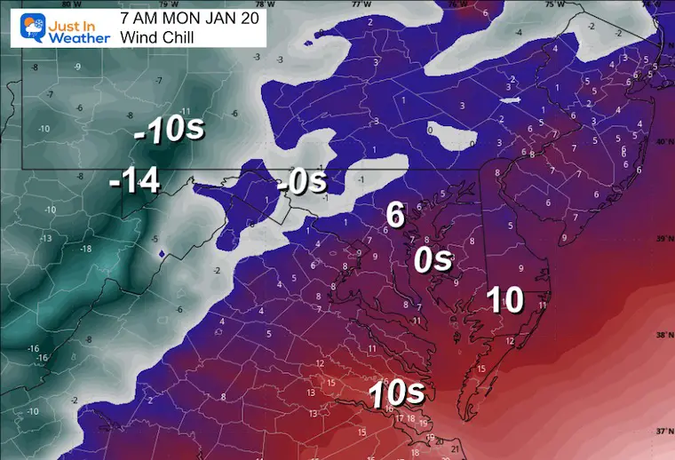
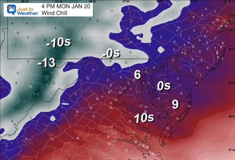
MONDAY WEATHER
Temperatures and Wind Chills
Morning
Wind Forecast
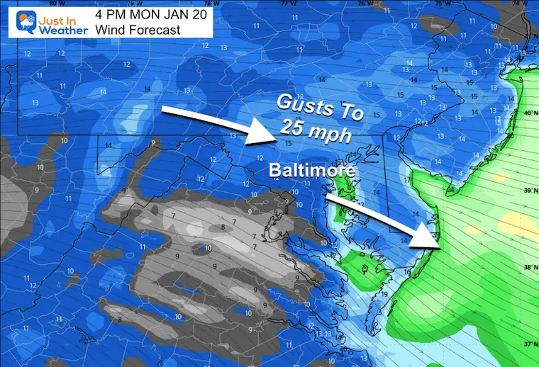
Afternoon
Work Week Outlook
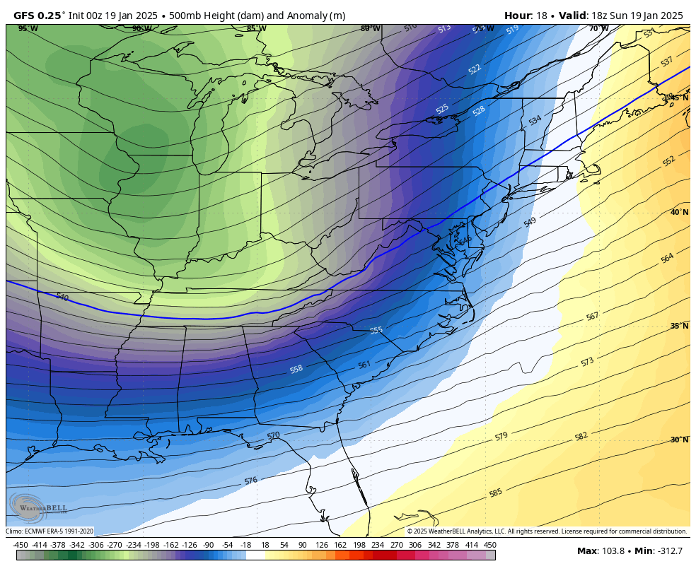
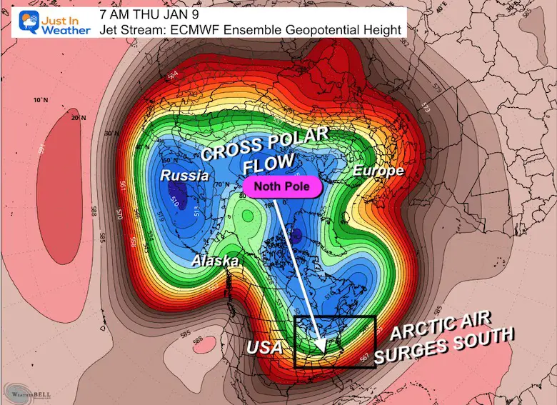
The Jet Stream will be dominated by the push of Polar Air. The actual Polar Vortex will be in Canada but dislodged to influence the ENTIRE Eastern US.
This may produce snow for the Gulf Coast, and we need to watch something try to slide along the Mid-Atlantic or Southeast Coast.
Jet Stream: Sunday Afternoon to Friday Evening
Storm Animations
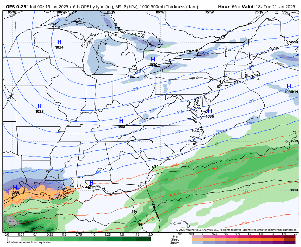
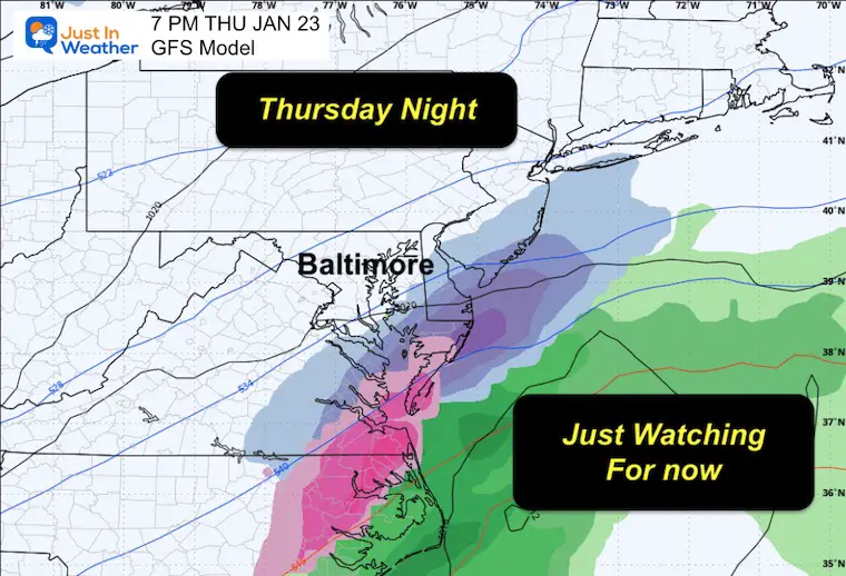
GFS Model: Tuesday Afternoon to Friday
ECMWF Model: Tuesday Afternoon to Friday
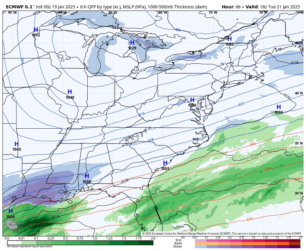
Snapshot:
The GFS has done the best with this Sunday storm, so I wanted to show it for the end of the week. This is NOT a promise, and I expect it to change as we get closer. It’s just something to watch.
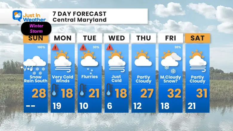
7 Day Forecast
Dangerously cold air will follow Monday.
We will remain BELOW FREEZING THROUGH THE WEEK!
Wind Chills will be lower.
Flurries may arrive on Tuesday, and some additional cloud cover may mitigate how cold we can get on Wednesday morning. This looks less intense than I have shown in prior days, but it is still extreme.
I have low confidence in the late-week snow chances, but I need to keep this a possibility.
Subscribe for eMail Alerts
SNOW REPORTS THIS SEASON
Click on the maps for that full report.
January 11 Snow Report

January 6 Snow Report

Previous Snow

ALSO SEE
Arctic Outbreak For January
If you missed it, here is my detailed report from December 30 about why this IS A BIG DEAL!
MY WINTER OUTLOOK
My Winter Outlook Report

FITF Gear on Sale

In Case You Missed This
The Faith In The Flakes Dec 5 Origin Story

Please share your thoughts and best weather pics/videos, or just keep in touch via social media.
SCHEDULE A WEATHER BASED STEM ASSEMBLY
Severe Weather: Storm Smart October and next spring Winter Weather FITF (Faith in the Flakes): November To March Click to see more and send a request for your school.

THANK YOU:
Baltimore Magazine Readers Choice Best Of Baltimore
Maryland Trek 11 Day 7 Completed Sat August 10
We raised OVER $104,000 for Just In Power Kids – AND Still Collecting More
The annual event: Hiking and biking 329 miles in 7 days between The Summit of Wisp to Ocean City.
Each day, we honor a kid and their family’s cancer journey.
Fundraising is for Just In Power Kids: Funding Free Holistic Programs. I never have and never will take a penny. It is all for our nonprofit to operate.
Click here or the image to donate:

RESTATING MY MESSAGE ABOUT DYSLEXIA
I am aware there are some spelling and grammar typos and occasional other glitches. I take responsibility for my mistakes and even the computer glitches I may miss. I have made a few public statements over the years, but if you are new here, you may have missed it: I have dyslexia and found out during my second year at Cornell University. It didn’t stop me from getting my meteorology degree and being the first to get the AMS CBM in the Baltimore/Washington region. One of my professors told me that I had made it that far without knowing and to not let it be a crutch going forward. That was Mark Wysocki, and he was absolutely correct! I do miss my mistakes in my own proofreading. The autocorrect spell check on my computer sometimes does an injustice to make it worse. I also can make mistakes in forecasting. No one is perfect at predicting the future. All of the maps and information are accurate. The ‘wordy’ stuff can get sticky. There has been no editor who can check my work while writing and to have it ready to send out in a newsworthy timeline. Barbara Werner is a member of the web team that helps me maintain this site. She has taken it upon herself to edit typos when she is available. That could be AFTER you read this. I accept this and perhaps proves what you read is really from me… It’s part of my charm. #FITF


