Snow Totals And Grade My Forecast For January 6 2025
The snowstorm that crossed the nation and hit the Mid-Atlantic region of the US was the largest many have seen in the last three years. It was talked about for over a week online, and rightly so, as we have seen with the results.
Record Snow Reports
Baltimore’s BWI = 6.6” (beat 3.9” in 1989)
Washington Dulles = 5.1” (beat 4.2” in 2015)
Note: Washington National hit 7.2” but was not a record.
I have many snowfall maps in this report…
I waited until I had 7 forecast days until the storm as a policy to not jump on any signal in the atmosphere. We still have a lot going on, and there is still the anticipation of an outstretched Polar Vortex and more snow events.
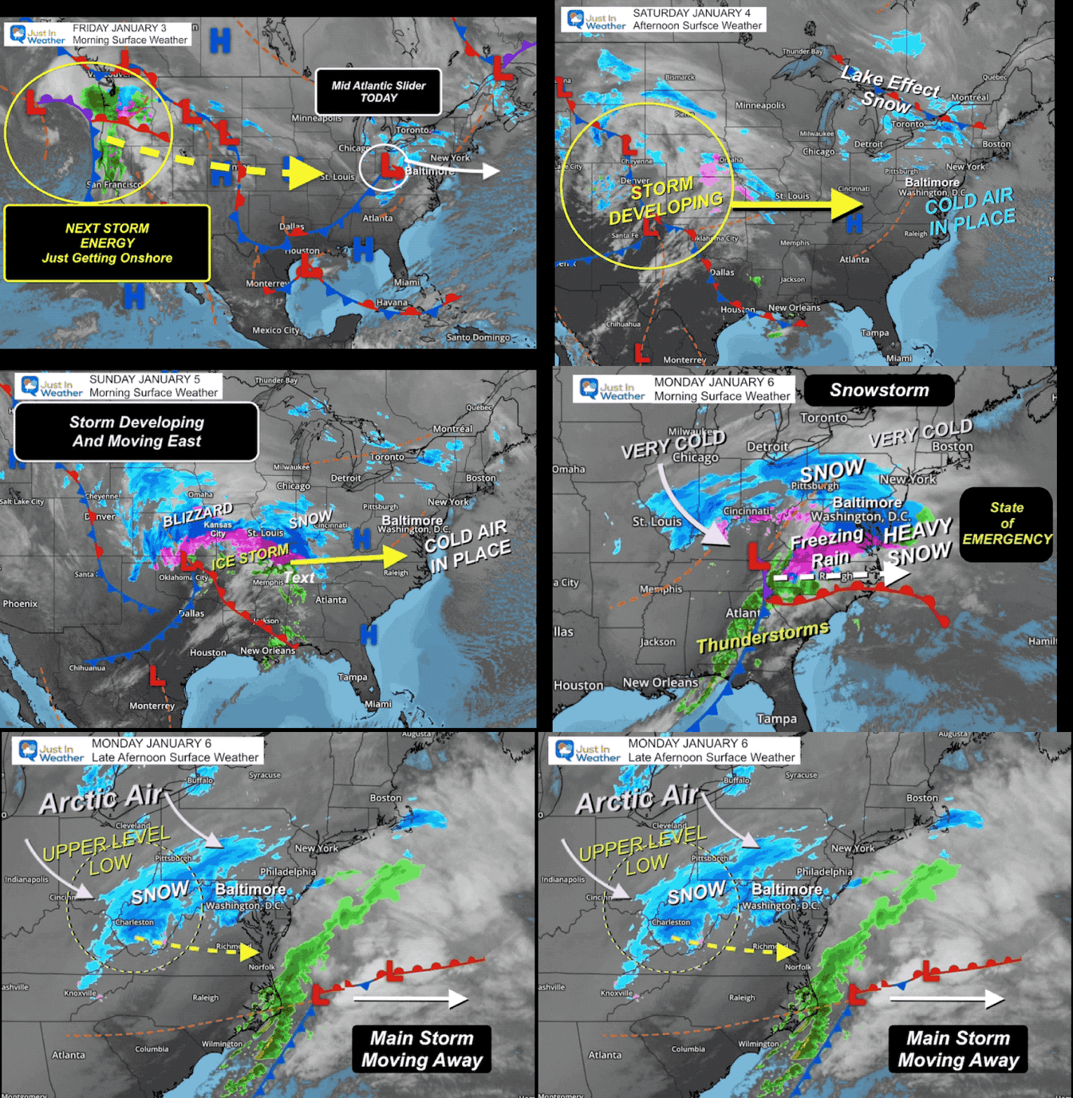
Storm Surface Weather Maps
January 3 to January 6
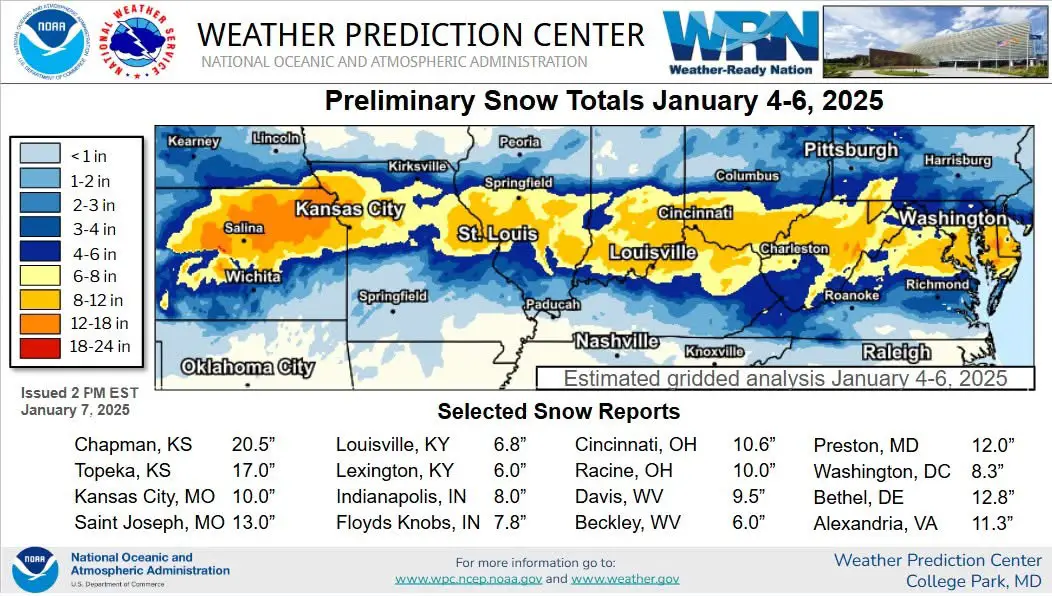
NWS Wide View Snow Totals
Kanas City, MO, got hit hardest with thundersnow, and true blizzard conditions.
I should have expanded that lower snow range into Northern Maryland to include the counties that border Pennsylvania.
*My Lower snow zone was off by roughly 30 miles, and it made a lot of people in Northern Maryland disappointed or even mad!
I do hope the information I provided you helped both give insight to some of what I look at in making a forecast, and the contrast of wide computer model forecast snow amounts.
Grade My Forecast
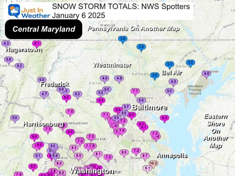
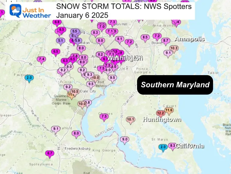
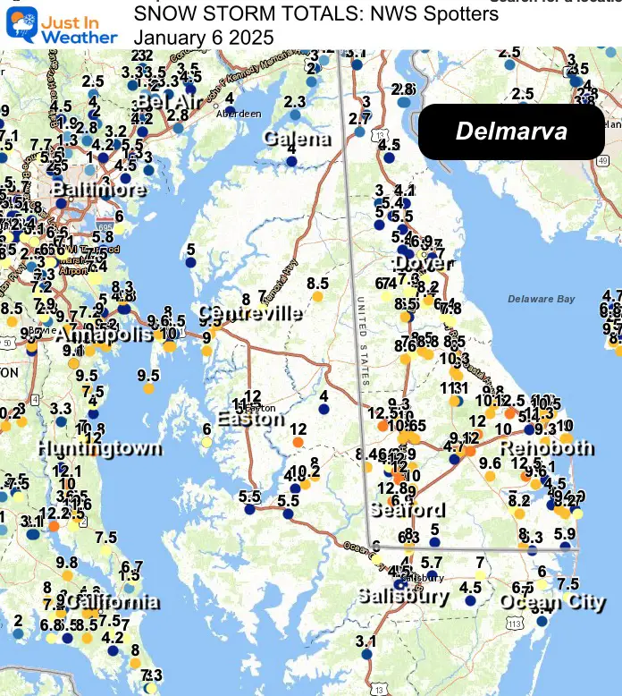
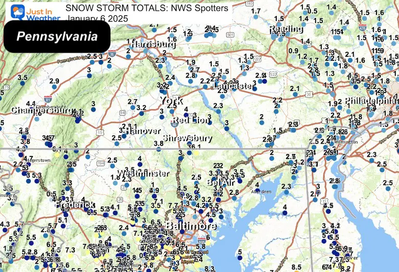
In this report, I want you to grade my forecast. I will briefly recap the storm and the results. There are many local maps, and a long list of National Weather Service Spotter reports from across Central Maryland.
Personal Note:
Overall, I think this was a good forecast. Here are quick notes on what I think worked and did not:
What I got right:
- The northward push of heavy snow did shift a little. Not as much as I thought.
- The mix of sleet and freezing rain did reach metro Washington and parts of Southern Maryland.
- My notion that the snow thump would include Annapolis!
- The bulk of my 6 to 12-inch snowfall range across Southern Maryland, Delaware, and the beaches
- I did purposely hold the lower end of 6 inches when I upped my range, and it worked out.
- I lowered my snow expectations in Southern PA to 3 to 6 inches in my final forecast.
What I got wrong (AKA BUST)
- I should have expanded my lower snow total an additional 30 miles southward across the Northern Counties of Maryland.
- I did not have the time to answer every question online about every specific zip code.
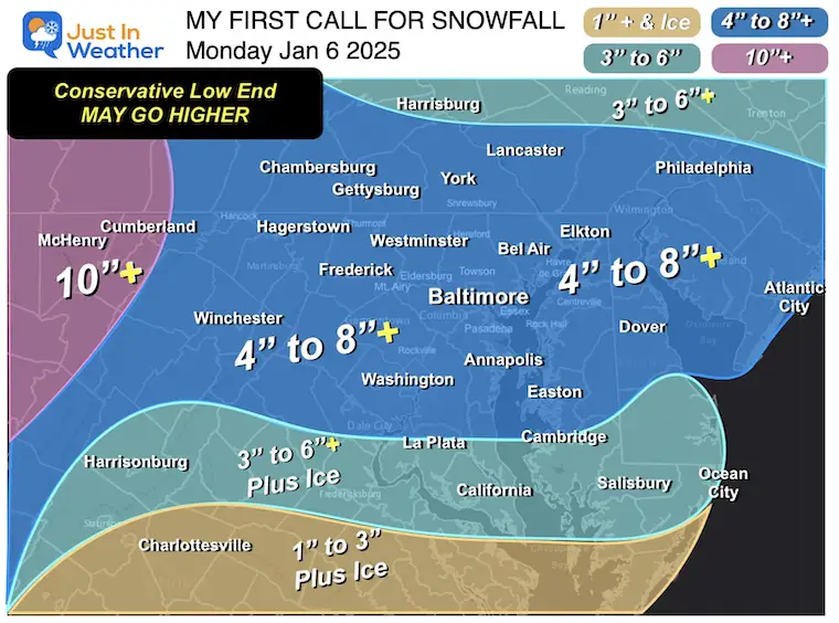
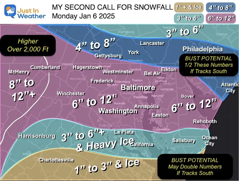
My Snow 3 Calls For Snowfall
- First Call Made Friday
- Second-Update Made Saturday
- Final Call Made Sunday Night
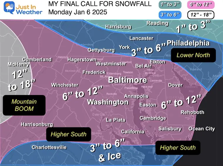
Snowfall Maps
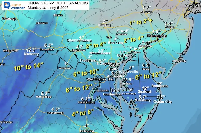
Regional Snow Total Maps
See the Spotter Report List Below
Maryland and Virginia
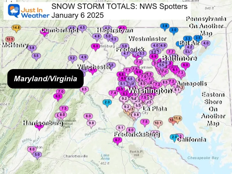
Central Maryland Closer View
Southern Maryland
Delmarva
Southern Pennsylvania
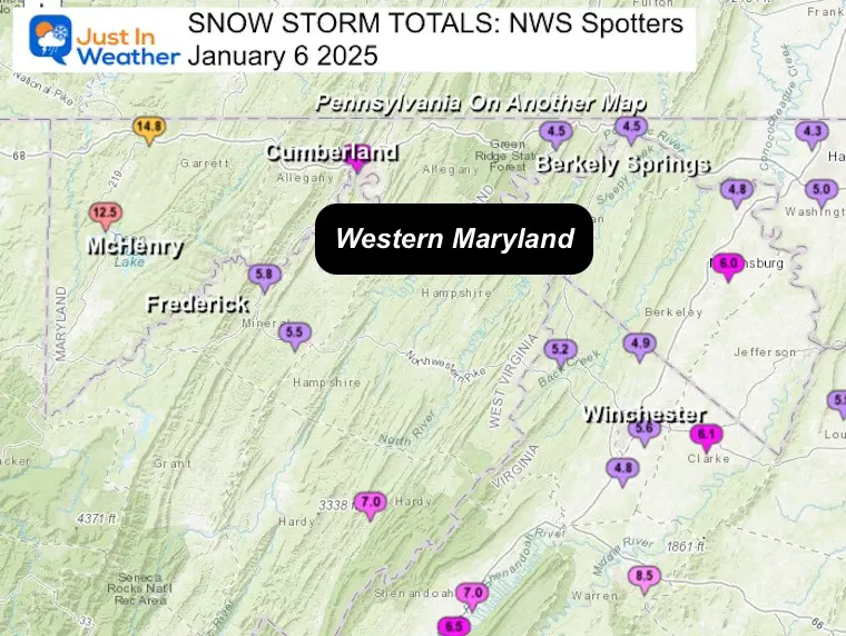
Western Maryland
NWS Baltimore/Washington Office
DC and Maryland Spotters
DISTRICT OF COLUMBIA
…District of Columbia… Washington 3 NE 8.3 700 AM 1/07
CoCoRaHS
Anacostia 1 N 7.7 343 PM 1/06 Public
Washington
1 E 6.8 1000 PM 1/06 Trained Spotter
Anacostia SSE 6.5
515 PM 1/06 Trained Spotter
Adams Morgan 1 SSE 6.5 730 PM 1/06
Trained Spotter
Anacostia 1 S 6.5 930 PM 1/06 Trained Spotter
American University 6.3 1224 PM 1/06 Broadcast Media
MARYLAND
…Allegany County…
Frostburg 7.3 700 AM 1/07 Co-
Op Observer
Wolfe Mill 2 NNE 6.5 521 PM 1/06 Trained Spotter
Ridgeley 1 NW 6.5 839 PM 1/06 Trained Spotter
Potomac
Park 2 NW 6.2 500 PM 1/06 Dept of Highways
Cumberland 5.2
700 AM 1/07 Co-Op Observer
Bellegrove 1 SSE 4.5 816 PM 1/06 Trained
Spotter
…Anne Arundel County…
BWI Airport 6.6 100 AM 1/07 Official NWS Obs
Londontowne 1 SSE 10.3 1130 PM 1/06
NWS Employee
Crownsville 3 SSW 9.7 700 AM 1/07 Trained
Spotter
Galesville 1 W 9.5 908 AM 1/07 NWS Employee
Annapolis 2 SW 9.5 445 PM 1/06 NWS Employee
Annapolis 1 S
9.2 630 AM 1/07 Trained Spotter
Birdsville WSW 9.1 700 AM
1/07 CoCoRaHS
Birdsville 9.1 1200 AM 1/07 NWS Employee
Severn 2
SSW 9.0 821 AM 1/07 CoCoRaHS
Parole 2 NE 9.0 700 AM
1/07 Trained Spotter
Annapolis 1 SE 9.0 815 AM 1/07 CoCoRaHS
Deale
1 SE 9.0 700 AM 1/07 CoCoRaHS
Annapolis 2 S 8.5 445 PM 1/06
NWS Employee
Cape St. Claire 8.3 1150 AM 1/06 Trained Spotter
Crofton 2 NNE 7.9 700 AM 1/07 NWS Employee
Crofton 1 SSE 7.8 700
AM 1/07 CoCoRaHS
Green Haven 1 ESE 7.5 615 AM 1/07 Trained Spotter
Churchton ENE 7.5 130 PM 1/06 Trained Spotter
Riva 1 NE 7.5 411 PM 1/06
Public
Hillsmere Shores 1 N 7.4 404 PM 1/06 Trained Spotter
Chelsea
Beach 7.4 1100 PM 1/06 Trained Spotter
Pasadena 1 ENE 7.3 905 PM
1/06 Trained Spotter Parole 7.2 500 PM 1/06 Dept of Highways
Odenton
1 S 7.2 1100 AM 1/06 Trained Spotter
Baltimore-Washington 7.0 500 PM
1/06 Dept of Highways
Odenton 1 WNW 7.0 145 PM 1/06 Trained
Spotter
Glen Burnie 1 WSW 6.1 1004 PM 1/06 Trained Spotter
…Baltimore County…
Owings Mills 7.1 500 PM 1/06
Dept of Highways
Catonsville 1 SSE 6.5 900 PM 1/06 Trained
Spotter
Edgemere SE 6.0 628 AM 1/07 Trained Spotter
Oella 2 NNE 5.7 1029 PM 1/06 Trained Spotter
White Marsh 2 E 5.5
1100 PM 1/06 Trained Spotter
Rosedale 2 S 5.0 700 AM 1/07 HADS
Glyndon 1 WSW 4.9 1100 PM 1/06 Trained Spotter
White Marsh 2 ESE 4.7 700 AM 1/07 CoCoRaHS
Towson 1 SW 4.4 830 AM 1/07
CoCoRaHS
Timonium NE 4.3 700 AM 1/07 CoCoRaHS Upper Falls 1 NNE
4.2 1100 PM 1/06 Trained Spotter
Kingsville 1 E 4.2 700 AM 1/07 CoCoRaHS
Fullerton 1 N 4.2 845 AM 1/07 Trained Spotter
Long Green 1 SW 4.1 700 AM 1/07 CoCoRaHS
Long Green 2 NW 4.0 900 PM 1/06
Trained Spotter
Reisterstown 1 NW 3.9 500 PM 1/06 CoCoRaHS
Randallstown 2 NW 3.5 330 PM 1/06 Trained Spotter
Bentley Springs 1 E 3.0 1000 PM 1/06 Trained Spotter
…Baltimore City…
Pimlico SE 5.5 624 AM 1/07 Trained Spotter
Mount Washington 1 N 5.3 800 AM 1/07 CoCoRaHS
Arlington 2 E 5.0 1040 PM 1/06 Broadcast Media
Baltimore 2 SW 4.5 952 AM 1/06 NWS Employee
Baltimore Martin Sta 4.5 1215 PM
1/06 Trained Spotter
Hamilton NE 4.1 600 AM 1/07 CoCoRaHS
…Calvert County…
Benedict 1 E 12.2 827 PM 1/06 Public
Huntingtown SW 12.1 1115 PM 1/06 Trained Spotter
Chesapeake Beach 12.0 445 PM 1/06 NWS Employee
Prince
Frederick 1 S 11.6 1010 PM 1/06 Trained Spotter
Huntingtown 3 NNW 11.0 700 AM 1/07 CoCoRaHS
North Beach 1 W 10.8 1230 PM 1/06 Trained Spotter
Prince Frederick 1 W 10.3 800 AM 1/07 CoCoRaHS
Huntingtown 3 SSW 10.0 1158 AM 1/06 Trained Spotter
Dunkirk 3.2NNE 9.7 800 AM 1/07 CoCoRaHS
Dowell 2 NE 8.5 400 PM 1/06 Trained Spotter
North Beach 2 WNW 7.0 800 AM 1/06 CoCoRaHS
…Carroll County…
Eldersburg 1 SE 5.5 700 AM 1/07
Trained Spotter
Eldersburg 1 E 5.5 700 AM 1/07 CoCoRaHS
Mount Airy SE 5.5 730 AM 1/07 CoCoRaHS
Sykesville 1 NNW
5.2 1030 PM 1/06 NWS Employee
Watersville 1 N 4.1 125 PM 1/06 Trained Spotter
Gamber 1 WNW 4.0 1030 PM 1/06 NWS Employee
Gamber 1 W 4.0 700 AM 1/07 CoCoRaHS
Marston 2 N 3.9 700 AM 1/07 CoCoRaHS
Millers 4 NE 3.8 1200 AM 1/07 Co-Op Observer
…Cecil County…
Galena 4 NW 4.0 900 AM 1/07
Cocorahs
Elkton 2 W 3.0 500 PM 1/06 Dept of Highways
Elkton 5 NW 2.9 700 AM 1/07 CoCoRaHS Pleasant Hill 2
SSE 2.7 1234 PM 1/06 Trained Spotter
…Charles County…
Waldorf 3 S 11.9 800 AM 1/07
CoCoRaHS
Dentsville 1 SW 10.1 1000 PM 1/06 Trained Spotter
Dentsville 3 WNW 10.0 1200 PM 1/06 Trained Spotter
Waldorf 2 W 9.3 1215 PM 1/06 Trained Spotter
Nanjemoy 5 S 9.0 700 AM 1/07 CoCoRaHS
Tompkinsville 4 WNW 9.0 1200 AM 1/07 Trained Spotter
Waldorf 8 ESE 9.0 800 AM 1/07 CoCoRaHS
La Plata 2 NNW 9.0 500 PM 1/06 Dept of Highways
Indian Head 9.0 1224 PM 1/06 Public
Bryantown 2 NE 8.9 700 AM 1/07 CoCoRaHS
La Plata 6 SE 8.5 1100 AM
1/06 CoCoRaHS
St. Charles 1 ENE 8.0 1229 PM 1/06 Trained Spotter
Welcome 2 WNW 7.8 735 AM 1/07 Trained Spotter
Charlotte Hall 2 NW 7.5 500 PM 1/06 Trained Spotter
…Frederick County…
Green Valley 1 WNW 6.5 850 PM 1/06
Public Fort Ritchie 1 SSE 6.1 828 PM 1/06 Trained Spotter
Point of Rocks 1 NE 5.7 800 AM 1/07 Trained Spotter
Mount Airy
1 WSW 5.3 1030 PM 1/06 Trained Spotter
New Market N 5.3 920 PM 1/06 Trained Spotter
Adamstown 1 ESE 5.1 600 AM 1/07 NWS Employee
Bloomfield 2 WSW 5.0 900 PM 1/06 NWS Employee
New Market 2 NW 5.0 800 PM 1/06 Trained Spotter
Ballenger Creek WSW 4.7 1000 PM 1/06 Trained Spotter
Braddock Heights 1 N 4.6 816 AM 1/06 Trained Spotter
Ballenger Creek 1 NN 4.2 1245 PM 1/06 Trained Spotter
Sabillasville 2 SSE 4.0 1130 AM 1/06 Trained Spotter
Mount Pleasant 2 SSE 4.0 1138 AM 1/06 Public
Lewistown 2 SSW 3.3 933 AM 1/06
Trained Spotter Middletown 3.2 700 AM 1/07 CoCoRaHS
…Garrett County…
Grantsville 5 W 14.8 100 AM 1/07 Dept
of Highways
Mc Henry 12.5 852 PM 1/06 Trained Spotter
Deer Park 6 NE 8.2 700 AM 1/07 Trained Spotter
Accident 4 SE 7.2 1159 PM 1/06 Public
McHenry 5 SSE 6.5 800 AM 1/06 CoCoRaHS
…Harford County…
Kingsville 3 NNE 7.5 1145 AM 1/06
CoCoRaHS Churchville 1 SE 4.5 500 PM 1/06 Dept of Highways
Aberdeen Proving Gro 4.0 1000 PM 1/06 Trained Spotter Bynum 1 E
3.5 724 AM 1/07 Trained Spotter Churchville 1 N 3.5 1020 PM 1/06
Trained Spotter Bel Air 2 E 3.3 748 AM 1/07 Trained Spotter Forest
Hill 3 SW 3.3 930 PM 1/06 Trained Spotter
…Howard County…
North Laurel 2 ESE 7.8 700 AM 1/07 CoCoRaHS
Simpsonville 1 SSE 7.8 1030 PM 1/06 Trained Spotter
Laurel 3 NNE 7.8 1015 PM 1/06 Trained Spotter
Simpsonville E 7.8 1115 PM 1/06 Trained Spotter
Columbia 7.7 800 AM 1/07 NWS Employee
Savage 1 ESE 7.5 715 PM 1/06 Trained Spotter
Columbia 3 SSE 7.3 700 AM 1/07 CoCoRaHS Laurel 1
NNE 7.2 600 AM 1/07 CoCoRaHS
Elkridge 2 W 7.2 1015 PM 1/06 Trained
Spotter Clarksville 2 N 7.1 1100 PM 1/06 Trained Spotter
Simpsonville 2 NNW 7.0 1150 PM 1/06 Trained Spotter
Gaither 2 SSE 7.0 740 AM 1/07 Trained Spotter
Laurel 1 N 6.8 445 PM 1/06 NWS Employee
Sykesville 2 SSE 6.8 700 AM 1/07 CoCoRaHS Simpsonville 6.5
508 PM 1/06 Trained Spotter
Daniels 1 S 6.5 1017 AM 1/06 Trained Spotter
Ellicott City 6.5 1100 PM 1/06 Broadcast Media
Elkridge 6.4 806 AM 1/07 NWS Employee
Elkridge 2 ESE 6.1 224 PM 1/06 Trained Spotter
Ellicott City 1 SW 5.9 815 AM 1/07 Trained Spotter
Elkridge 2 WSW 5.8 600 PM 1/06 Trained Spotter
Ilchester 1 W 5.5 732 PM 1/06 Trained Spotter
Hanover ENE 5.5 1000 AM 1/06 Trained Spotter
Columbia 2 NW 5.5 1100 AM 1/06 Trained Spotter
Historic Ellicott City 5.5 1057 AM 1/06 NWS Employee
Columbia 1 N 5.5 814 PM 1/06 Trained Spotter
Columbia 2 NNW 5.3 737 AM 1/07 CoCoRaHS
…Montgomery County…
Potomac 8.3 938 PM 1/06
Emergency Mngr
Langley Park 1 W 8.1 1200 AM 1/07 Trained
Spotter
Glen Echo 1 WNW 8.0 725 PM 1/06 Emergency Mngr
North Potomac 4 N 7.5 700 AM 1/07 CoCoRaHS
Germantown 2 WSW 7.5
1100 PM 1/06 Trained Spotter
Glenmont 1 S 7.5 725 PM 1/06
Emergency Mngr
Norbeck 1 ESE 7.3 700 AM 1/07 CoCoRaHS
Poolesville
NE 7.3 1050 PM 1/06 Trained Spotter
Colesville 2 W 7.3 700 AM 1/07 CoCoRaHS
Rockville 7.2 951 PM 1/06 NWS Employee
Garrett Park 1 ENE 7.1 1100 PM 1/06 Trained Spotter
Washington Grove 1 N 7.0 300 PM 1/06 Trained Spotter
Rockville 1 SSE 7.0 1010 PM 1/06
Trained Spotter Garrett Park 2 NW 7.0 1205 AM 1/07 Trained Spotter
Potomac 1 NNW 7.0 700 AM 1/07 CoCoRaHS
Damascus 3 SSW 7.0 847 PM 1/06
Co-Op Observer Potomac 3 NE 7.0 700 AM 1/07 CoCoRaHS
Colesville 1 SE 7.0 115 PM 1/06 Trained Spotter
Gaithersburg 2 E 7.0 717 AM 1/07
NWS Employee Silver Spring 6 NNE 6.9 503 AM 1/07 CoCoRaHS
Colesville 6.8 1125 AM 1/06 Trained Spotter
Damascus 1 S 6.8 700 AM 1/07 CoCoRaHS
Montgomery Village 1 6.6 630 AM 1/07 CoCoRaHS
Gaithersburg 1 SW 6.6 1003 PM 1/06 Trained Spotter
Ashton-Sandy Springs 6.5 700 AM 1/07
CoCoRaHS Four Corners 1 N 6.5 224 AM 1/06 Trained Spotter
Gaithersburg 3 NE 6.4 700 AM 1/07 CoCoRaHS
Gaithersburg 1 E 6.3 1239 PM 1/06
Public Four Corners 2 NW 6.0 1234 PM 1/06 Trained Spotter
Damascus 1 SE 6.0 700 AM 1/06 Trained Spotter
Laytonsville 5 NNW 6.0 700 AM 1/06 CoCoRaHS
White Oak 1 N 6.0 700 AM 1/07 CoCoRaHS
…Prince George County…
Fort Washington 1 SS 10.5 700 AM 1/07
CoCoRaHS Marlton 1 WSW 10.2 745 AM 1/07 Trained Spotter
Tantallon 3 SE 8.8 204 PM 1/06 Trained Spotter
Glenn Dale 1 NNE 8.5 1000 PM 1/06 NWS Employee
Beltsville 1 NNW 8.0 830 AM 1/07 CoCoRaHS
Bowie 2 SSE 8.0 510 PM 1/06 NWS Employee
Suitland 2 SE 7.5 700 AM 1/07 CoCoRaHS
University Park 1 E 7.2 1055 PM 1/06 NWS Office
Greenbelt 1 SE 7.0 958 AM 1/07 Trained Spotter
Greenbelt 1 N 7.0 700 AM 1/07 CoCoRaHS
Savage 1 WNW 6.2 445 PM 1/06 Trained Spotter
College Park 1 S 6.1 800 AM 1/07 Trained Spotter
…St. Marys County…
Sandgates 1 S 9.8 954 AM 1/07 Trained Spotter
California 2 W 9.8 1230 PM 1/06 Trained Spotter
Leonardtown 9.0 1130 AM 1/06 Trained Spotter
Callaway 2 W 8.5 1150 AM 1/06 Trained Spotter
Hollywood 3 S 8.3 1020 PM 1/06 Trained Spotter
Clements 3 E 8.0 500 PM 1/06 Dept of Highways
Leonardtown SSE 7.5 1126 AM 1/06 Trained Spotter
Great Mills 1 NNE 7.5 1147 AM 1/06 Trained Spotter
Leonardtown 1 SW 7.4 828 AM 1/06 Trained Spotter
Ridge 1 N 7.3 700 AM 1/07 CoCoRaHS
Ridge 1 ENE 7.3 700 AM 1/07 Trained Spotter
…Washington County…
Hagerstown 1 ENE 7.7 700 AM 1/07 CoCoRaHS
Boonsboro 3 NNE 5.3 1000 PM 1/06 Trained Spotter
Funkstown 2 SSW 5.0 902 PM 1/06 Public
Hancock 1 ESE 4.5 700 AM 1/07 CoCoRaHS
Williamsport 3 ENE 4.3 600 AM 1/07 CoCoRaHS
Maugansville WSW 4.3 930 PM 1/06 Trained Spotter
Hagerstown 4 NNW 4.3 700 AM 1/07 CoCoRaHS
Pecktonville 3 NNW 4.0 700 AM 1/07 NWS Employee
Southern Pennsylvania
…Pennsylvania…
…Adams County…
1 NW Cashtown 4.1 in 0700 PM 01/06 Trained Spotter
Cashtown 1 S 4.1 in 0700 AM 01/07 COOP
2 SW Mcsherrystown 3.2 in 0945 PM 01/06 Trained Spotter
Biglerville 3.0 in 0730 AM 01/07 COOP
East Berlin 2.7 in 0430 PM 01/06 Public
…Lancaster County…
2 W Lancaster 4.0 in 0800 PM 01/06 Broadcast Media
2.1 SE New Holland 4.0 in 1200 AM 01/07 COOP
3 NNW Paradise 3.0 in 0503 PM 01/06 Trained Spotter
Holtwood 3.0 in 0700 AM 01/07 COOP
Lancaster 3.0 in 0700 AM 01/07 COOP
1 E Lancaster 2.8 in 0126 PM 01/06 Public
Maytown 2.8 in 0537 PM 01/06 Public
2 SE Rheems 2.7 in 0440 PM 01/06 Public
Lancaster 5.8 WNW 2.7 in 0700 AM 01/07 COCORAHS
Millersville 2.5 in 0100 PM 01/06 Public
New Holland 1.4 SSW 2.5 in 0725 AM 01/07 COCORAHS
Landisville 1.2 ESE 2.5 in 0800 AM 01/07 COCORAHS
Safe Harbor 2.3 in 0700 AM 01/07 COOP
1 NNE Columbia 2.2 in 0700 AM 01/07 Public
…York County…
Red Lion 4.0 in 0205 PM 01/06 Public
3 WNW Emigsville 3.2 in 0730 PM 01/06 Public
East Berlin 3.4 ESE 3.2 in 0600 AM 01/07 COCORAHS
1 SE Hanover 3.1 in 0700 AM 01/07 Public
Brogue 3.0 in 0500 PM 01/06 Trained Spotter
1 SE New Salem 3.0 in 0725 AM 01/07 Trained Spotter
1 WNW Spry 2.5 in 0500 PM 01/06 Trained Spotter
Manchester 0.7 NNW 2.4 in 0700 AM 01/07 COCORAHS
Valley Green 2.3 in 0535 AM 01/07 Public
York 4.2 NNW 2.2 in 0700 AM 01/07 COCORAHS
Subscribe for eMail Alerts
Weather posts straight to your inbox
Sign up and be the first to know!
ALSO SEE
Previous Snow
November 22 Snow Report
Arctic Outbreak For January
If you missed it, here is my detailed report from December 30 about why this IS A BIG DEAL!
MY WINTER OUTLOOK
FITF Gear on Sale
In Case You Missed This
The Faith In The Flakes Dec 5 Origin Story
Please share your thoughts and best weather pics/videos, or just keep in touch via social media.
-
Facebook: Justin Berk, Meteorologist
-
Twitter
-
Instagram
SCHEDULE A WEATHER BASED STEM ASSEMBLY
Severe Weather: Storm Smart October and next spring Winter Weather FITF (Faith in the Flakes): November To March Click to see more and send a request for your school.
THANK YOU:
Baltimore Magazine Readers Choice Best Of Baltimore
Maryland Trek 11 Day 7 Completed Sat August 10
We raised OVER $104,000 for Just In Power Kids – AND Still Collecting More
The annual event: Hiking and biking 329 miles in 7 days between The Summit of Wisp to Ocean City.
Each day, we honor a kid and their family’s cancer journey.
Fundraising is for Just In Power Kids: Funding Free Holistic Programs. I never have and never will take a penny. It is all for our nonprofit to operate.
Click here or the image to donate:
RESTATING MY MESSAGE ABOUT DYSLEXIA
I am aware there are some spelling and grammar typos and occasional other glitches. I take responsibility for my mistakes and even the computer glitches I may miss. I have made a few public statements over the years, but if you are new here, you may have missed it: I have dyslexia and found out during my second year at Cornell University. It didn’t stop me from getting my meteorology degree and being the first to get the AMS CBM in the Baltimore/Washington region. One of my professors told me that I had made it that far without knowing and to not let it be a crutch going forward. That was Mark Wysocki, and he was absolutely correct! I do miss my mistakes in my own proofreading. The autocorrect spell check on my computer sometimes does an injustice to make it worse. I also can make mistakes in forecasting. No one is perfect at predicting the future. All of the maps and information are accurate. The ‘wordy’ stuff can get sticky. There has been no editor who can check my work while writing and to have it ready to send out in a newsworthy timeline. Barbara Werner is a member of the web team that helps me maintain this site. She has taken it upon herself to edit typos when she is available. That could be AFTER you read this. I accept this and perhaps proves what you read is really from me… It’s part of my charm. #FITF


