Saturday Morning, January 4 2025
A large winter storm is moving through the Rockies. It will push into the Central Plains and get better organized. This event has been tracked for a long time and still has complications for what it will bring. There is high confidence that there will be an impact across the US starting Sunday in the Mid West and then Monday across the Mid-Atlantic. This will affect schools and work travel.
I am going to show the broader view, then focus more on the Mid-Atlantic (home base) and highlight that the two main computer models represent the wide spread. The other models we review are tracking in between.
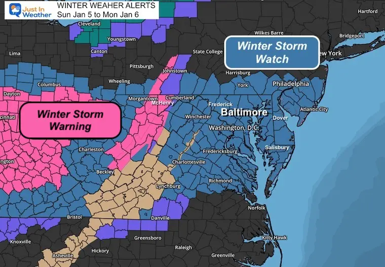
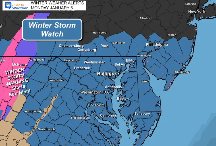
Winter Storm Watches and Warnings
Wider View (closer look below)
Note: The Warning is an UPGRADE just based on time… when the event is expected to begin within 24 hours. More details on the local advisory map below.
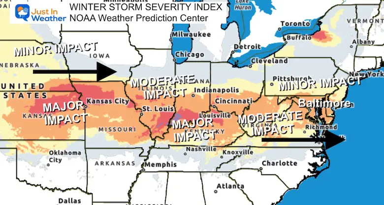
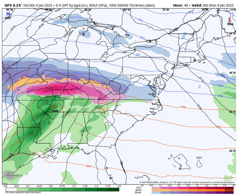
NOAA Winter Storm Severity Index
Large areas are in Moderate to Major, with both snow and freezing rain/ice storm.
Compare Storm Track Animations 7 PM Sunday to 7 AM Tuesday
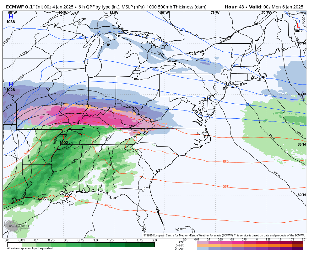
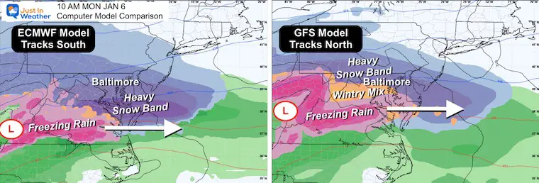
ECMWF Model
This has continued to track the start farther south… bringing the heavier snow band South of I-70 and a major ice storm for Southern Illinois, most of Kentucky, and Southern Virginia.
GFS Model
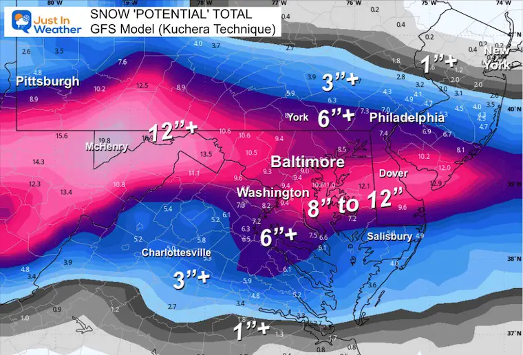
This continues to track a little north, bringing the heavier snow near and North of I-70. This pushes that heavier snow into Pennsylvania.
It also introduces the sleet and freezing rain into Washington and Baltimore.
Side By Side Comparison: 10 AM Monday, January 6
Local Look
Winter Storm Watch
Our region will mostly be affected on Monday. This includes a Warning for the mountains to begin earlier… by Sunday Evening.
Compare Snow (and ice) Forecast Maps
Warning Criteria
A Winter Storm Warning is issued when a significant combination of hazardous winter weather is occurring or imminent.
- Significant and hazardous winter weather is defined as a combination of:
5 inches or more of snow/sleet within a 12-hour period or 7 inches or more of snow/sleet within a 24-hour period
AND/OR
- Enough ice accumulation to cause damage to trees or powerlines.
AND/OR
- A life-threatening or damaging combination of snow and/or ice accumulation with wind.
The snow/sleet criteria for a Winter Storm Warning for the five westernmost counties (Allegany, Mineral, Grant, Pendleton, and Highland) is higher (6 inches or more within a 12-hour period; 8 inches or more within a 24-hour period).
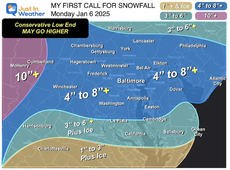
My First Call For Snowfall
I am confident on this lower end, with the potential to go higher. We need to consider the potential for ice creeping farther north and affecting totals in the DMV (DC, Maryland, Virginia) region.
Quick Highlights
- Snow will develop after midnight on Sunday night. By daybreak Monday morning, it will be snowing at moderate to high intensity across the Mid-Atlantic.
- Schools and work will be affected.
- The reliable European Model has been most consistent, but it has trended SOUTHWARD, putting heavier snow South of Baltimore.
- The American GFS Model has been bouncing around but has a history of high performance within 72 hours. This tracks North with heavy snow and a possible icy mix reaching central Maryland. It also puts heavier snow farther north into Pennsylvania.
Snow Forecast Maps
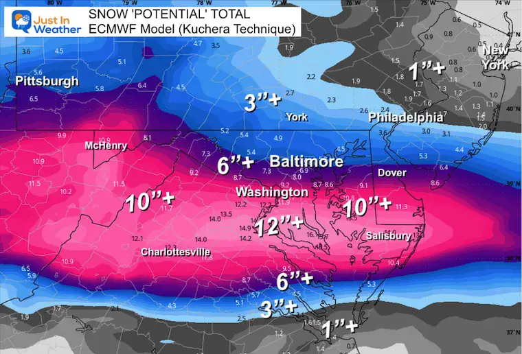
European ECMWF Model
This tracks farther south and moves away earlier.
American GFS Model
This tracks farther north, then tries to redevelop off the coast like a Miller B. This keeps the snow going longer into Tuesday morning.
It also brings in sleet and Freezing Rain close to Washington and Baltimore.
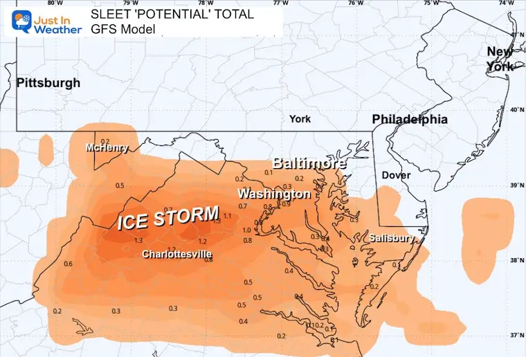
Sleet Forecast: GFS Model
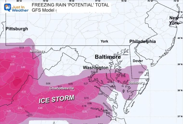
Freezing Rain Forecast: GFS Model
National Weather Service Office Maps
These ONLY go through 7 PM on Monday. That may not be the end of the storm.
Notice the WIDE RANGE. There is low confidence in totals.
Compare the overlapping areas, and you will notice they are NOT THE SAME. Compare Southern Pennsylvania and Delmarva.
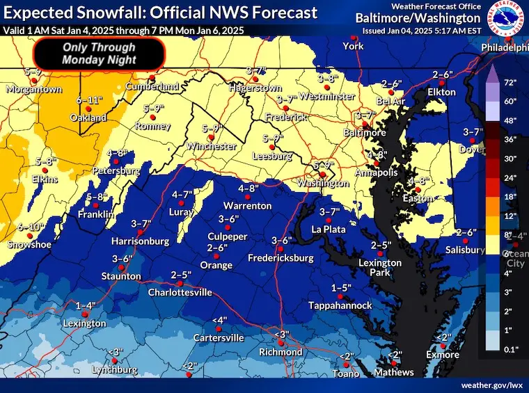
NWS Baltimore/Washington Office
Reminder: This is what I see as a conservative call. There is potential to go higher, and you will see those higher numbers in the model plots below.
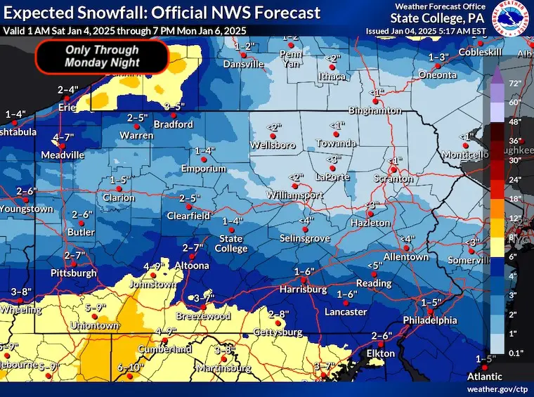
NWS State College PA Office
This is considered a baseline for a major storm in the Mid-Atlantic metro areas.
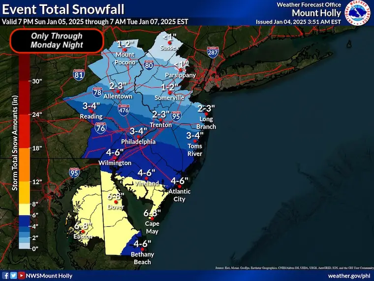
NWS Mount Holly NJ/Philadelphia Office
What I am now looking for:
Model Consistency and or consensus. Is there a trend in one direction with the track, or is one model getting closer to the other, holding stronger?
Nowcasting: Seeing how the models verify 6 to 12 hours after each run to identify any bias.
I believe we need to take the GFS model seriously, with the track and influence of an icy mix.
If and when I see a significant reason, I will make updates. This will include adding a more realistic higher end OR where the icy may mix in.
Faith in the Flakes, We will get snow!
#FITF
Subscribe for eMail Alerts
ALSO SEE
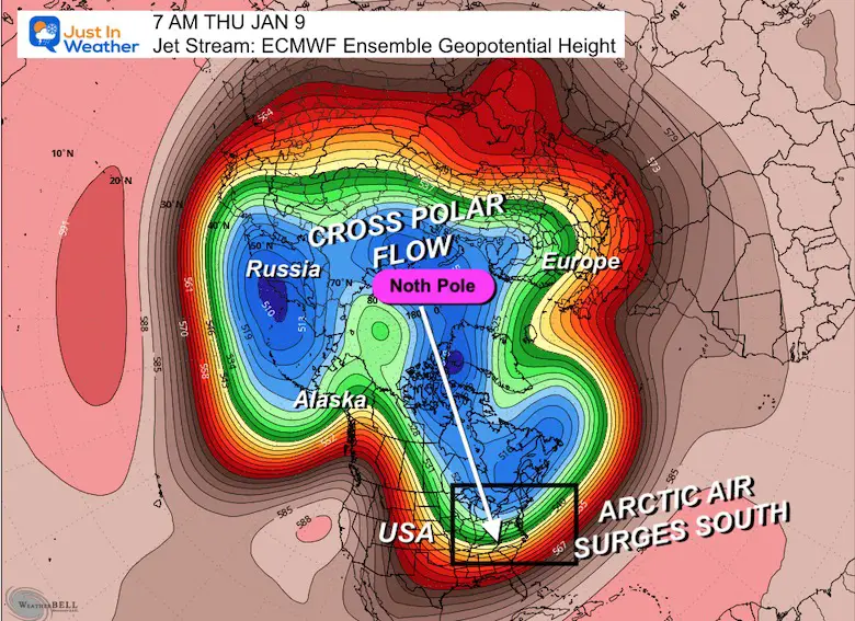
Arctic Outbreak For January
If you missed it, here is my detailed report from December 30 about why this IS A BIG DEAL!
MY WINTER OUTLOOK
My Winter Outlook Report

FITF Gear on Sale

In Case You Missed This
The Faith In The Flakes Dec 5 Origin Story

Previous Snow

Please share your thoughts and best weather pics/videos, or just keep in touch via social media.
SCHEDULE A WEATHER BASED STEM ASSEMBLY
Severe Weather: Storm Smart October and next spring Winter Weather FITF (Faith in the Flakes): November To March Click to see more and send a request for your school.

THANK YOU:
Baltimore Magazine Readers Choice Best Of Baltimore
Maryland Trek 11 Day 7 Completed Sat August 10
We raised OVER $104,000 for Just In Power Kids – AND Still Collecting More
The annual event: Hiking and biking 329 miles in 7 days between The Summit of Wisp to Ocean City.
Each day, we honor a kid and their family’s cancer journey.
Fundraising is for Just In Power Kids: Funding Free Holistic Programs. I never have and never will take a penny. It is all for our nonprofit to operate.
Click here or the image to donate:

RESTATING MY MESSAGE ABOUT DYSLEXIA
I am aware there are some spelling and grammar typos and occasional other glitches. I take responsibility for my mistakes and even the computer glitches I may miss. I have made a few public statements over the years, but if you are new here, you may have missed it: I have dyslexia and found out during my second year at Cornell University. It didn’t stop me from getting my meteorology degree and being the first to get the AMS CBM in the Baltimore/Washington region. One of my professors told me that I had made it that far without knowing and to not let it be a crutch going forward. That was Mark Wysocki, and he was absolutely correct! I do miss my mistakes in my own proofreading. The autocorrect spell check on my computer sometimes does an injustice to make it worse. I also can make mistakes in forecasting. No one is perfect at predicting the future. All of the maps and information are accurate. The ‘wordy’ stuff can get sticky. There has been no editor who can check my work while writing and to have it ready to send out in a newsworthy timeline. Barbara Werner is a member of the web team that helps me maintain this site. She has taken it upon herself to edit typos when she is available. That could be AFTER you read this. I accept this and perhaps proves what you read is really from me… It’s part of my charm. #FITF


