November 14 2024
NOAA still has a La Niña Watch in place. The latest odds are 57% chance for conditions to develop by December and last into early 2025. Expectations have been lowered for a weak and short duration event. A weak event would be less likely to have an impact on our winter, which could be good news if you want a better chance for more snow.
For reference, Last month’s forecast was a 60% chance of La Niña developing by now (November) and lasting into the winter. This had actually dropped from 71% forecast odds in September.
We’ve had the hottest summer on record AND the longest streak of dry days across much of the Eastern US. Now that we are on the cusp of Winter, one valuable tool is examining global weather patterns to see how the storm track may set up in the months ahead.
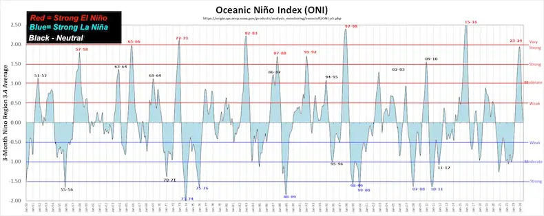
After a triple dip El Niño in the Pacific Ocean, there has been an expectation for the flip to colder water resulting in a La Niña.
Let’s take a look at what this is AND the forecast update.
What is La Niña?
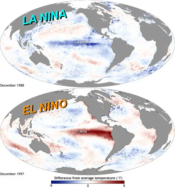
Every 3 to 7 years, there is a flip or reversal of ocean currents in the tropical Pacific Ocean along the equator. Compared to the ‘normal’ years, this can result in Warmer Temperatures during El Niño and cooler temperatures during La Niña.
Time Chart Since 1950
IRI Chart
International Research Institute For Climate and Society
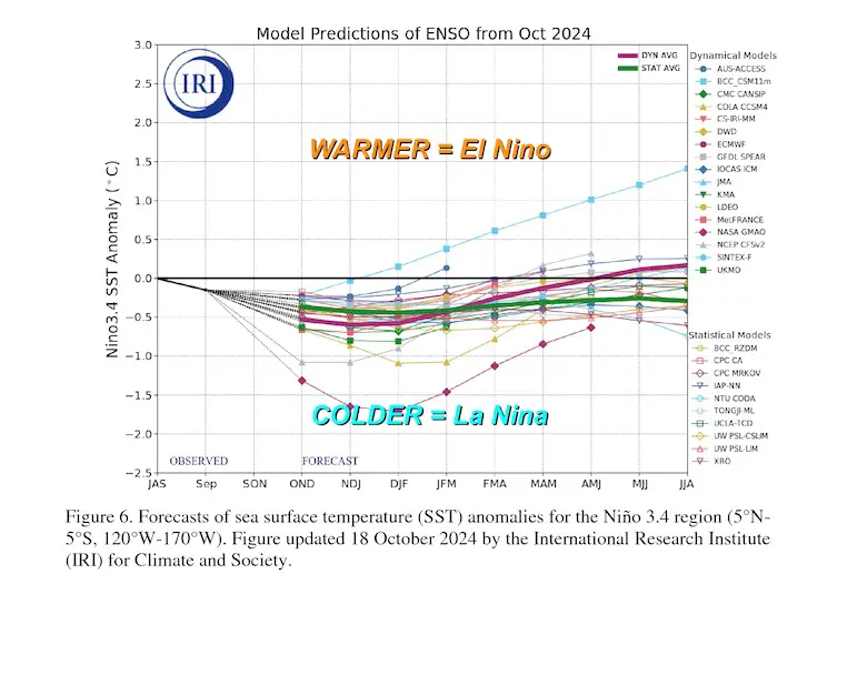
Forecast Water Temperature Anomalies In The Pacific Ocean along the equator.
Cooler temperatures support a La Niña. This forecast for a weak La Niña between 0.5ºC and 1.0ºC below average.
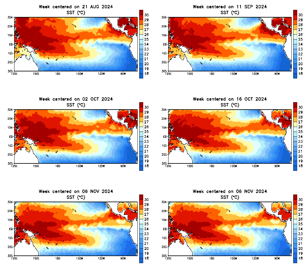
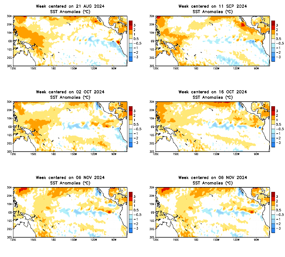
Sea Surface Temperatures: August to Novmeber
Observed Water Temperatures
Anomalies: Contrasting Above and Below Average Readings
This animation shows the measurements of the water temperature compared to the average. Warmer water is represented by yellow and orange, and colder water is represented by blue. As we can see, the BLUE has been expanding.
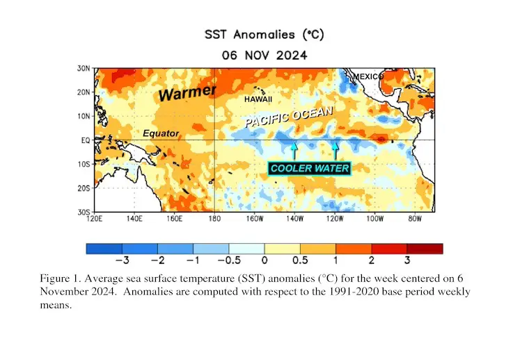
Snapshot: November 6
Here, we see the upwelling of cooler water from the western shores of South America and the reversal flow feeding cooler water westward across to the central Pacific Ocean.
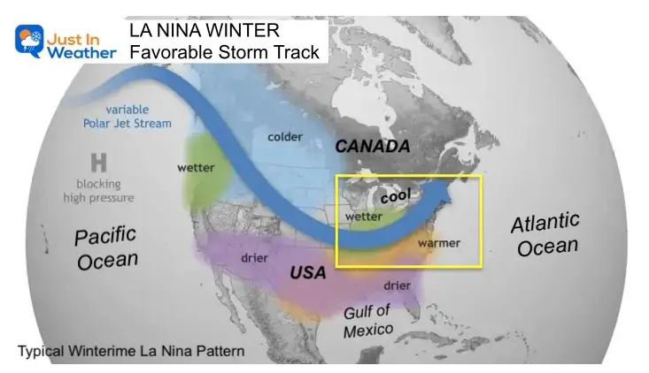
Resulting WINTER STORM TRACK across North America
A more detailed look at previous La Niña Winters in Baltimore is below.
The storm track from the Pacific Ocean tends to take a northern route, diving across the Central Plains and then up the Ohio Valley.
I want to emphasize that this is the NOAA map for a ‘typical La Niña’ storm pattern. It is not static for the entire season.
I put the yellow box over the Mid-Atlantic. We are in a region that can be on the edge of the storm track.
THIS LOOKS WARM AND WET, HOWEVER…..
- A shift of this suggested storm pattern a little South can switch the snow zone into metro areas.
- There are other factors that can shift this south and colder for us, or west and warmer. It is possible to average a warm pattern and still get a few strong cold storms.
NOAA WINTER OUTLOOK ‘SUGGESTION’
Click here for the NOAA Report. This was based on La Niña Developing and a reminder that there was high expectation that it would form by now.
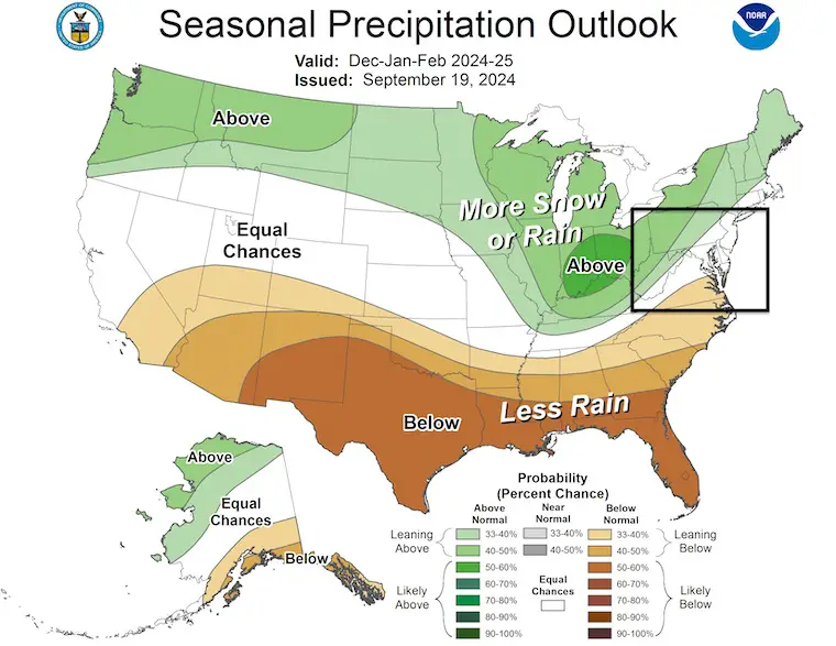
Precipitation
The more active Jet Stream would cause more frequent stormy events crossing the country from the Pacific to the East Coast, bringing above-average snow or rain.
Less active weather pattern to the south across the Gulf Coast states.
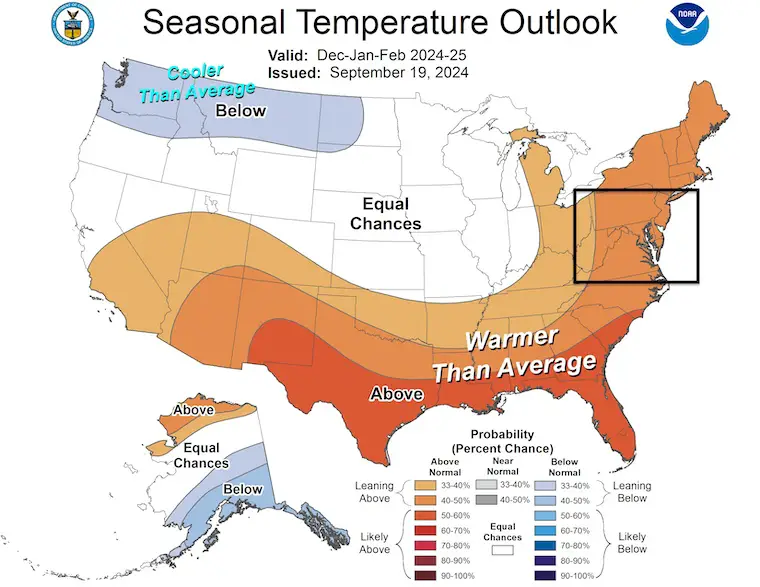
Temperatures
A Typical La Niña would keep the zonal flow from West to East and not allow many arctic intrusions from the North.
*A Weak La Niña may not hold off that cold as much… something we need to apply and could be different than the standard La Niña.
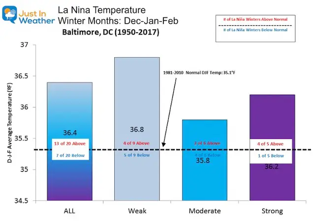
History Of La Niña In Baltimore
These are averages from past events, not promises. Other factors affect storm tracks.
Temperatures
Warmer than normal 65% of the La Niña Winters.
Cooler than normal 35% of La Niña Winters.
- Weak La Niña is even chances.
- Moderate La Niña is most likely to bring colder temperatures.
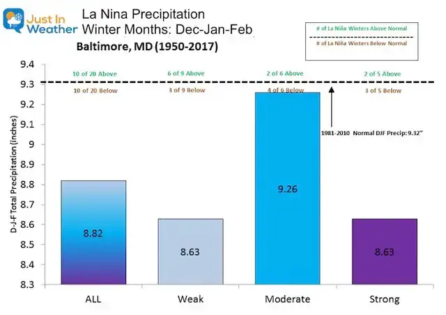
Precipitation
This is total precipitation for rain and snow.
Overall, there is an even split. But this chart can be confusing. A Moderate La Niña has had 4 of 6 times been below average, but the chart has the largest total. This is because when there is an above-average pattern, it can be WAY ABOVE AVERAGE to offset the total comparison.
Snowfall
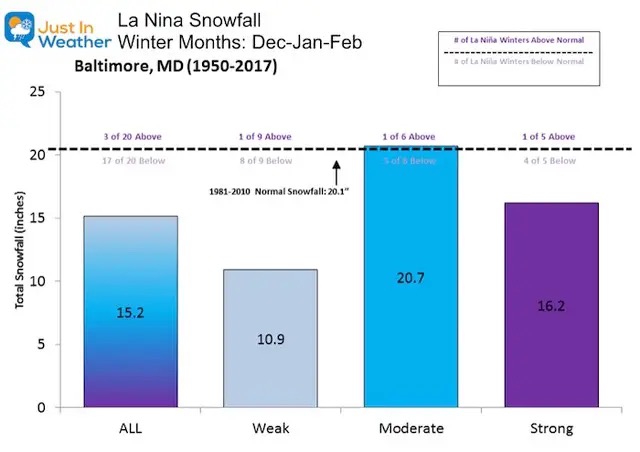
If you have Faith in the Flakes, this might not be what you want to see. But there is a silver lining. While most years show below-normal snow, there have been some big exceptions.
- 1996- January Blizzard was in a La Niña year. This also accounted for most of the snow that winter.
- 2000 – Most of the snowfall that winter was in a 10-day period between January 20 and 30. This included the ‘surprise’ Nor’easter that brought 14.9″ of snow to BWI on January 25.
CONSIDER THIS
If you base the winter just on La Niña and want more snow, then you would want a Moderate La Niña for more snow.
The latest NOAA report did suggest we may get a weak event with little to no impact on our winter. The level is intensity will be worth paying attention to.
We have had big snowstorms within a mild winter.
There are many other factors that could play a larger role locally.
The weather has been bonkers lately, and not performing as expected. I expect we will not end up with a typical La Niña winter like shown above.
I will have my final winter outlook shortly. I like what I am seeing.
CLICK TO EXPLORE MORE
Chart showing Cold and Warm Periods By Season since 1950
Winter Outlook Comparing Two Farmers Almanacs
La Nino and El Nino Explained By NOAA
Subscribe for eMail Alerts
Weather posts straight to your inbox
Sign up and be the first to know!
Please share your thoughts and best weather pics/videos, or just keep in touch via social media.
-
Facebook: Justin Berk, Meteorologist
-
Twitter
-
Instagram
SCHEDULE A WEATHER BASED STEM ASSEMBLY
Severe Weather: Storm Smart October and next spring
Winter Weather FITF (Faith in the Flakes): November To March
Click to see more and send a request for your school.
THANK YOU:
Baltimore Magazine Readers Choice Best Of Baltimore
Maryland Trek 11 Day 7 Completed Sat August 10
We raised OVER $104,000 for Just In Power Kids – AND Still Collecting More
The annual event: Hiking and biking 329 miles in 7 days between The Summit of Wisp to Ocean City.
Each day, we honor a kid and their family’s cancer journey.
Fundraising is for Just In Power Kids: Funding Free Holistic Programs. I never have and never will take a penny. It is all for our nonprofit to operate.
Click here or the image to donate:
RESTATING MY MESSAGE ABOUT DYSLEXIA
I am aware there are some spelling and grammar typos and occasional other glitches. I take responsibility for my mistakes and even the computer glitches I may miss. I have made a few public statements over the years, but if you are new here, you may have missed it: I have dyslexia and found out during my second year at Cornell University. It didn’t stop me from getting my meteorology degree and being the first to get the AMS CBM in the Baltimore/Washington region.
One of my professors told me that I had made it that far without knowing and to not let it be a crutch going forward. That was Mark Wysocki, and he was absolutely correct! I do miss my mistakes in my own proofreading. The autocorrect spell check on my computer sometimes does an injustice to make it worse. I also can make mistakes in forecasting. No one is perfect at predicting the future. All of the maps and information are accurate. The ‘wordy’ stuff can get sticky.
There has been no editor who can check my work while writing and to have it ready to send out in a newsworthy timeline. Barbara Werner is a member of the web team that helps me maintain this site. She has taken it upon herself to edit typos when she is available. That could be AFTER you read this. I accept this and perhaps proves what you read is really from me… It’s part of my charm. #FITF


