November 8, 2024
Friday Morning Report
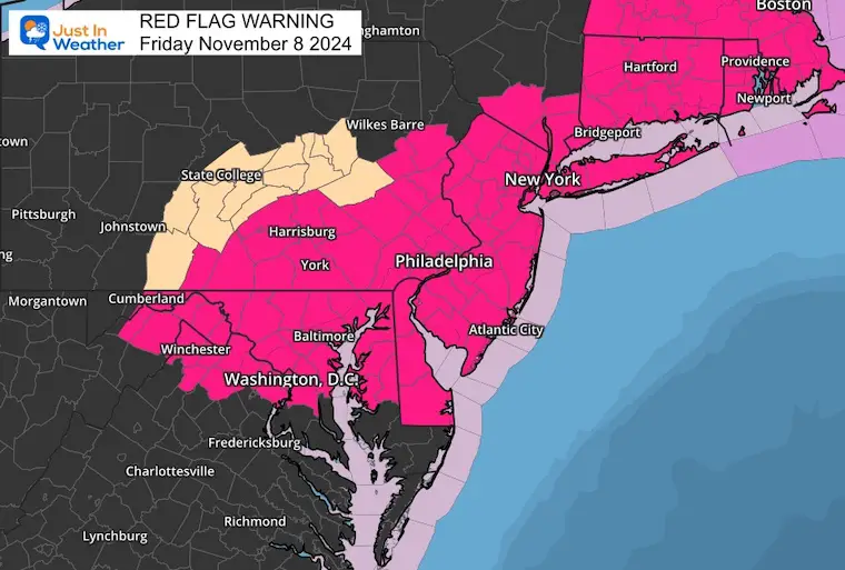
The low-temperature on Thursday was 63ºF, the warmest since 1938. This morning is much cooler as the new air mass is moving in. The problem is that we remain very dry, and gusty winds today will enhance the fire risk. A Red Flag Warning has been issued for the Mid-Atlantic through New England.
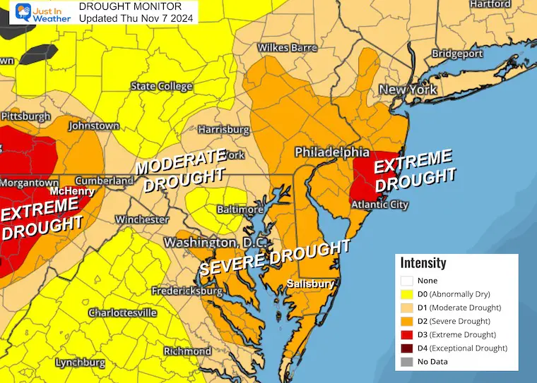
Baltimore Drought Update
- No Measurable Rain Since October 2nd = 37 Days!
- There was a ‘trace’ on October 4th and November 1st.
- Rainfall DOWN -6.77” since Sep 1
Red Flag Warning
- TIMING…From noon today to 6 PM EST this evening.
- WINDS…West 10 to 15 mph with gusts up to 30 mph.
- RELATIVE HUMIDITY…As low as 20 percent.
- IMPACTS…The combination of dry conditions, low humidity, and strong gusty winds may result in favorable conditions for the rapid spread of fires.
Morning Surface Weather
Temperatures are cooling down with the first of two cold fronts in the Eastern US. The winds and very dry conditions are why we have the elevated fire danger.
Farther west, we see that snowstorm slowly moving east of the Rockies and sending rain into the Central Plains. This is the storm we will watch for us by Sunday.
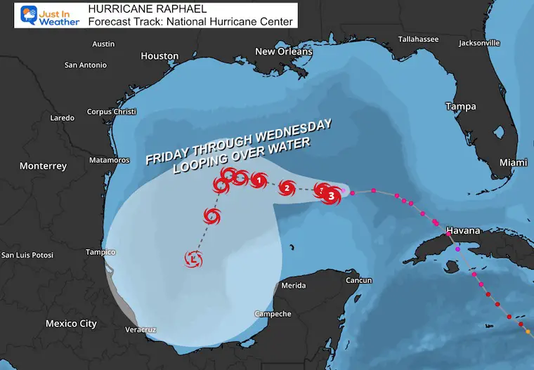
Hurricane Rafael is back to a Category 3 storm. It is expected to remain over the water and loop in the Western Gulf for the next five days.
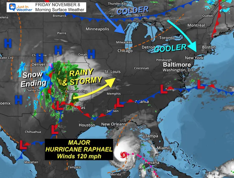
I want to focus on the Hurricane first, then the local weather and extended forecast below.
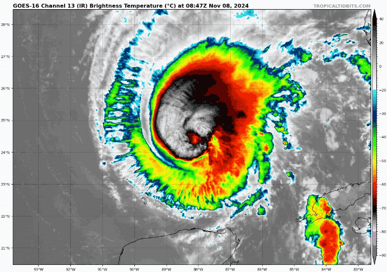
Hurricane Rafael Satellite
- Hurricane-force winds reach only 30 miles from the center.
- Tropical Storm force winds reach 115 miles from the center.
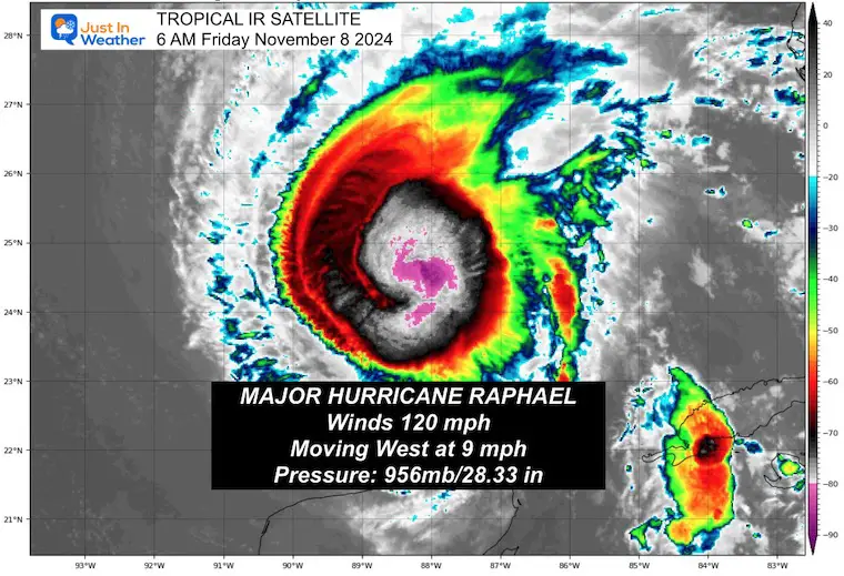
National Hurricane Center Update at 4 AM EST
- LOCATION…24.5N 88.0W
- ABOUT 245 MI…395 KM NNE OF PROGRESO MEXICO
- ABOUT 585 MI…940 KM E OF MOUTH OF THE RIO GRANDE
- MAXIMUM SUSTAINED WINDS…120 MPH…195 KM/H
- PRESENT MOVEMENT…W OR 275 DEGREES AT 9 MPH…15 KM/H
- MINIMUM CENTRAL PRESSURE…956 MB…28.23 INCHES
Tropical Satellite Loop
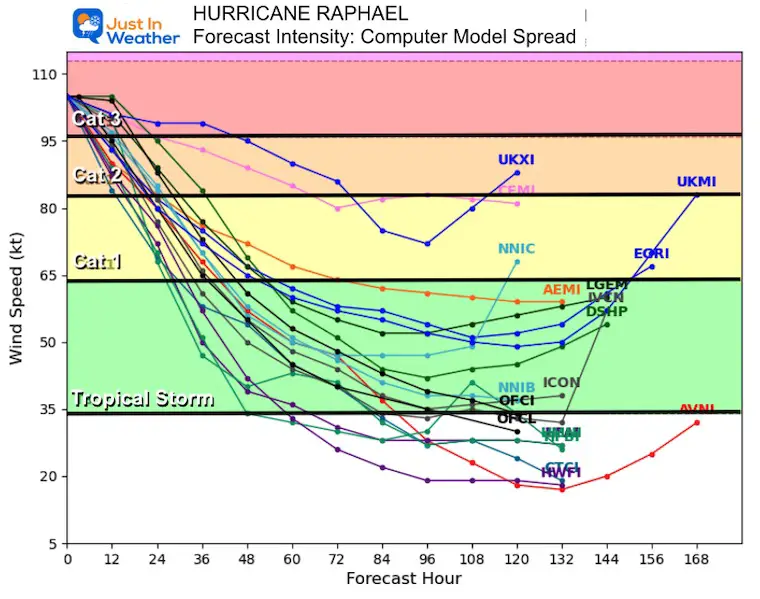
Forecast Intensity
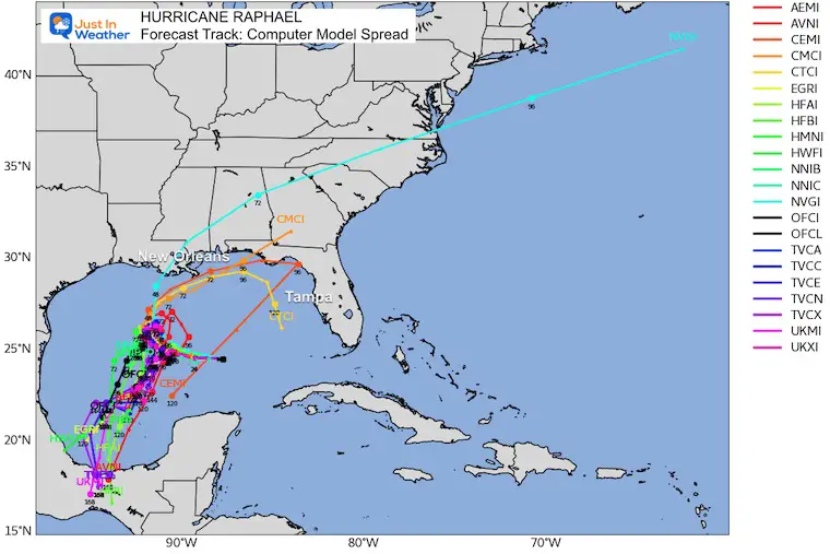
Forecast Tracks
Computer Model Spread
There is a lot of uncertainty with this storm, so the timing and location of landfall have low confidence.
National Hurricane Center
NHC has it looping in the Gulf of Mexico and not making landfall.
SUMMARY OF WATCHES AND WARNINGS IN EFFECT:
A Tropical Storm Warning is in effect for…
LOCAL WEATHER
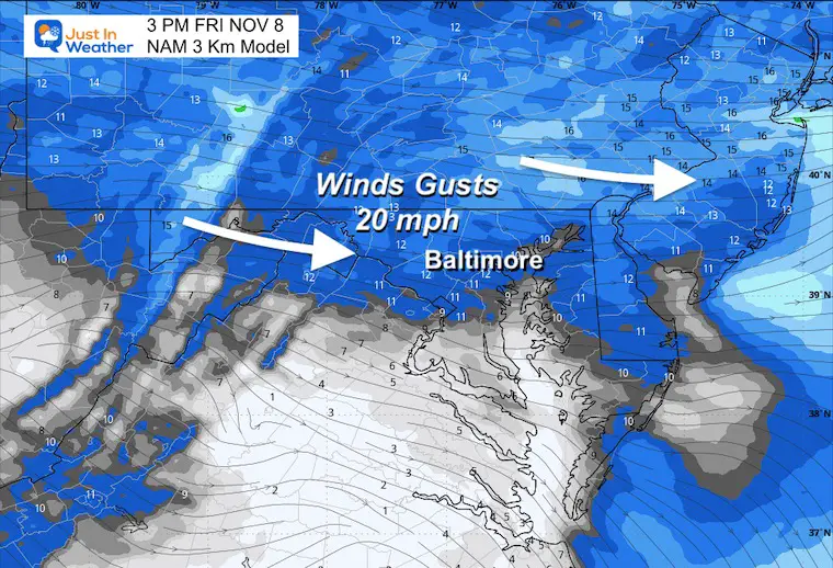
Wind Forecast
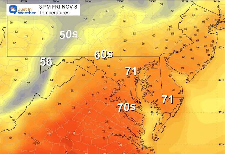
Afternoon Forecast Temperatures
No records, but still 70s near and south of Baltimore. The cooler air will be felt first to the west and in northern areas.

CLIMATE DATA: Baltimore
TODAY November 8
Sunrise at 6:43 AM
Sunset at 4:58 PM
Normal Low in Baltimore: 39ºF
Record 24ºF in 1960
Normal High in Baltimore: 60ºF
Record 80ºF 1975
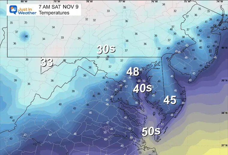
SATURDAY NOVEMBER 9
Cooling down back closer to average. The breeze will continue from the North at 10 to 20 mph.
Morning Lows
Afternoon Highs
Weekend Weather: Saturday through Monday
High Pressure will move off the coast, allowing the next cold front to arrive. This is looking a little more wet, enough to carry more rain east of the mountains.
While Hurricane Rafael will stay in the Gulf of Mexico, some moisture may get captured and feed up north into the front.
Sunday Afternoon
Sunday will start dry for the Bay Bridge Run, with increasing clouds and seasonably chilly temps.
The cold front should be more active, with rain expanding eastward.
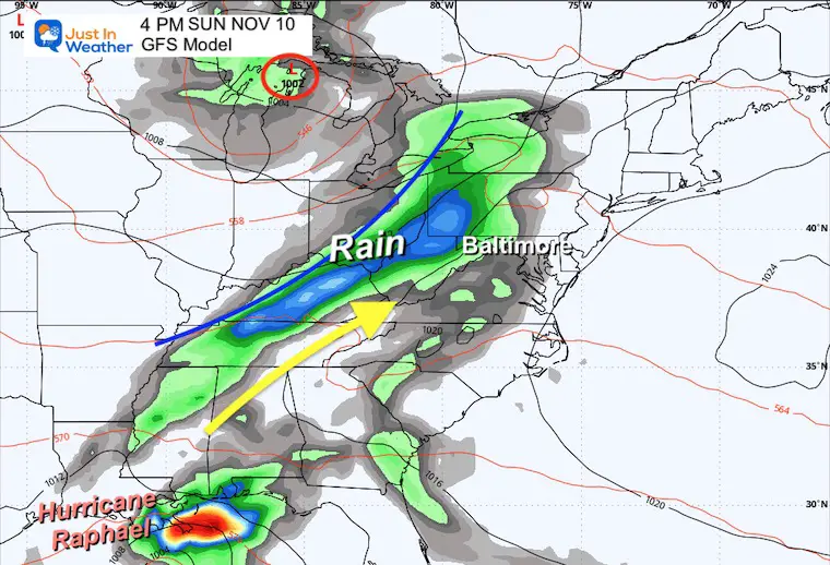
Sunday Night:
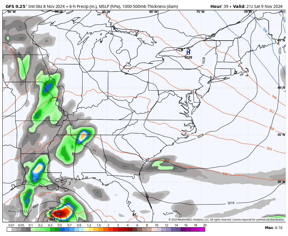
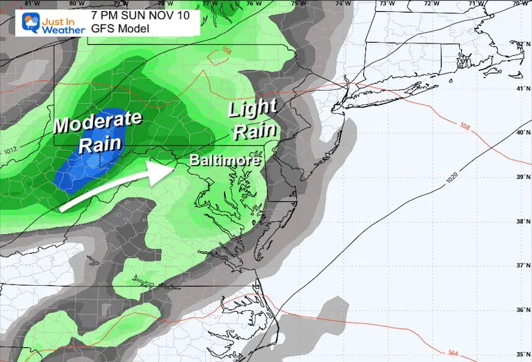
GFS Model
This continues to be the more robust solution with moderate rain later in the evening and overnight.
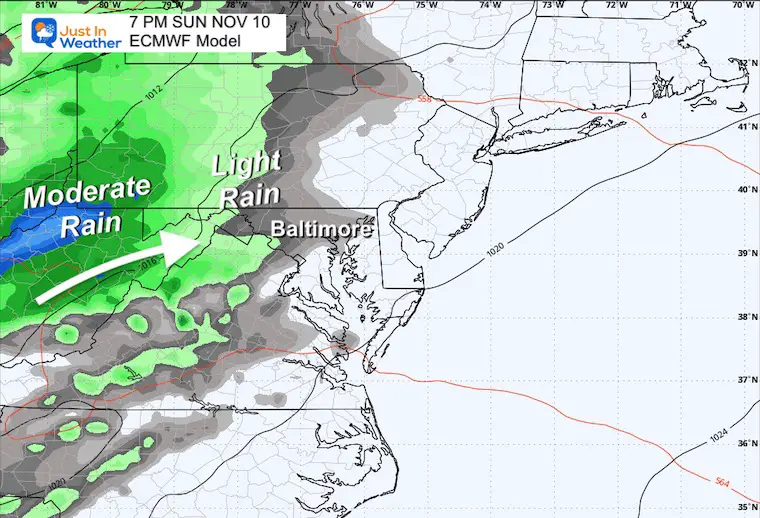
ECMWF Model
This model has increased the rain, but it is a little less active. Light to moderate rain will arrive overnight.
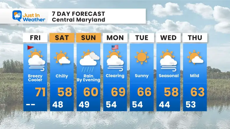
7 Day Forecast
Temps will cool back closer to normal or average this weekend. By late Sunday afternoon through overnight, there will be more clouds and rain.
Subscribe for eMail Alerts
FIRST FROST DATES
Here are the average dates across Maryland, and they match the advisories we saw last week.
Click this image to see more details across Maryland and Pennsylvania.

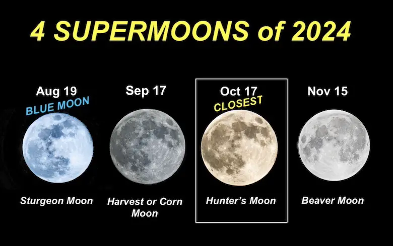
FOUR SUPERMOONS OF 2024
Click here for more
Please share your thoughts and best weather pics/videos, or just keep in touch via social media.
SCHEDULE A WEATHER BASED STEM ASSEMBLY
Severe Weather: Storm Smart October and next spring
Winter Weather FITF (Faith in the Flakes): November To March
Click to see more and send a request for your school.

THANK YOU:
Baltimore Magazine Readers Choice Best Of Baltimore
Maryland Trek 11 Day 7 Completed Sat August 10
We raised OVER $104,000 for Just In Power Kids – AND Still Collecting More
The annual event: Hiking and biking 329 miles in 7 days between The Summit of Wisp to Ocean City.
Each day, we honor a kid and their family’s cancer journey.
Fundraising is for Just In Power Kids: Funding Free Holistic Programs. I never have and never will take a penny. It is all for our nonprofit to operate.
Click here or the image to donate:

RESTATING MY MESSAGE ABOUT DYSLEXIA
I am aware there are some spelling and grammar typos and occasional other glitches. I take responsibility for my mistakes and even the computer glitches I may miss. I have made a few public statements over the years, but if you are new here, you may have missed it: I have dyslexia and found out during my second year at Cornell University. It didn’t stop me from getting my meteorology degree and being the first to get the AMS CBM in the Baltimore/Washington region.
One of my professors told me that I had made it that far without knowing and to not let it be a crutch going forward. That was Mark Wysocki, and he was absolutely correct! I do miss my mistakes in my own proofreading. The autocorrect spell check on my computer sometimes does an injustice to make it worse. I also can make mistakes in forecasting. No one is perfect at predicting the future. All of the maps and information are accurate. The ‘wordy’ stuff can get sticky.
There has been no editor who can check my work while writing and to have it ready to send out in a newsworthy timeline. Barbara Werner is a member of the web team that helps me maintain this site. She has taken it upon herself to edit typos when she is available. That could be AFTER you read this. I accept this and perhaps proves what you read is really from me… It’s part of my charm. #FITF


