


January 6 Weather Some Fog And Clouds Followed By The Warm Up With Rain By The Weekend
Tuesday, January 6, 2026 The storm track has shifted to the north. We are still on the edge, which is why we have areas of fog, and most of the…
Thursday October 17, 2024
There has been much speculation that we are due for a harsh winter. After the warmest summer on record, severe drought, and two major hurricanes in the past month, something has to translate to winter, right? After seven years of below-average snowfall in much of the Eastern US, the balance must shift to more snow, right?
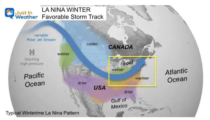
Well, according to the latest Winter Outlook for 2024 to 2025 from NOAA, that is not necessarily the case. As I wrote yesterday, there is a 60% chance of La Niña developing before winter. This cool water pattern in the tropical Pacific can affect the storm pattern across North America, and historically, it tends to be warmer.
But the La Niña forecasted is not here yet AND if it happens is expected to be weak. So how much affect can it have? Well, they roughly call for wetter North which would ease the snow across the Great Lakes. Meanwhile the soggy South may end up warmer and drier.
“This winter, an emerging La Niña is anticipated to influence the upcoming winter patterns, especially our precipitation predictions,” said Jon Gottschalck, chief of the Operational Prediction Branch of the Climate Prediction Center.
An active storm track can pass directly over the Mid-Atlantic, which would be warmer if it tracks just north, but it can be cold and snowy if it passes south.
NOAA:
A slowly developing La Niña is favored to influence conditions for the upcoming winter across most of the country, according to NOAA’s U.S. Winter Outlook, released today by the Climate Prediction Center, a division of NOAA’s National Weather Service. This outlook is for December 2024 through February 2025 and contains information on likely conditions throughout the country for temperature, precipitation, and drought.
This winter, NOAA predicts wetter-than-average conditions for the entire northern tier of the continental U.S., particularly in the Pacific Northwest and the Great Lakes region, along with northern and western Alaska. Meanwhile, drier-than-average conditions are expected from the Four Corners region of the Southwest to the Southeast, Gulf Coast, and lower mid-Atlantic states.
An investment of $100 million has been made in NOAA’s high-performance computer system to advance research on weather, climate, and ocean predictions.
Note: This map favors warming for the East Coast. However, that is an average for the season, but there can still be some arctic outbreaks.
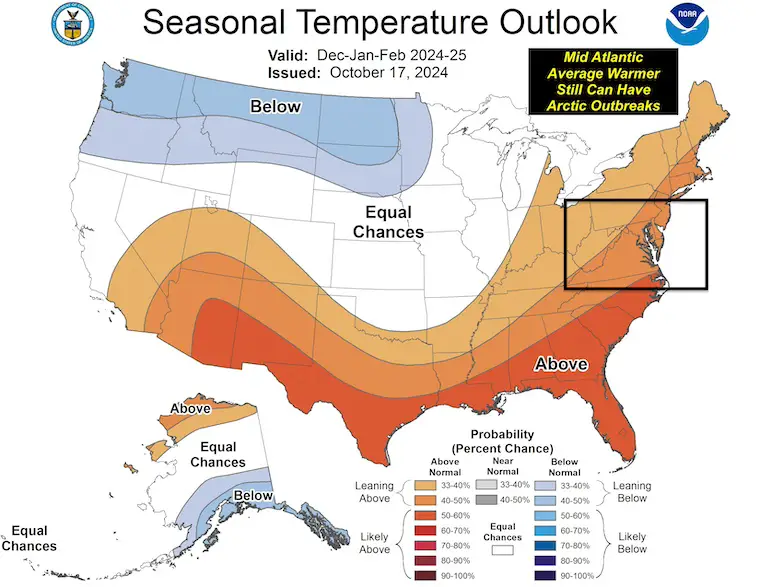
My Interpretation: Our Mid-Atlantic region is in that ambitious zone of “equal chances”. This does NOT mean any support for or against the snow. Either way, get your chimney sweep appointment ready!
In my humble opinion, any shift of the active storm track just a little farther south can bring more activity and colder air, resulting in snow.
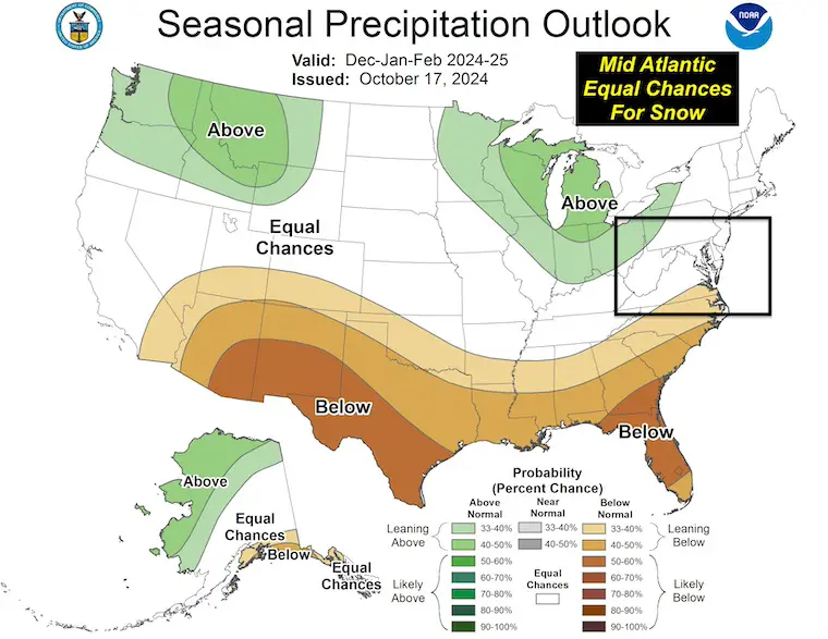
My Interpretation: NOAA has left this ambiguous for the Mid-Atlantic.
There is relief in sight. We should get back to more weather systems that bring rain or snow… at least near normal, to help recover dry streams and reservoirs.
Chart showing Cold and Warm Periods By Season since 1950
Winter Outlook Comparing Two Farmers Almanacs
Sign up and be the first to know!
Severe Weather: Storm Smart October and next spring
Winter Weather FITF (Faith in the Flakes): November To March
Click to see more and send a request for your school.

The annual event: Hiking and biking 329 miles in 7 days between The Summit of Wisp to Ocean City.
Each day, we honor a kid and their family’s cancer journey.
Fundraising is for Just In Power Kids: Funding Free Holistic Programs. I never have and never will take a penny. It is all for our nonprofit to operate.
Click here or the image to donate:

I am aware there are some spelling and grammar typos and occasional other glitches. I take responsibility for my mistakes and even the computer glitches I may miss. I have made a few public statements over the years, but if you are new here, you may have missed it: I have dyslexia and found out during my second year at Cornell University. It didn’t stop me from getting my meteorology degree and being the first to get the AMS CBM in the Baltimore/Washington region.
One of my professors told me that I had made it that far without knowing and to not let it be a crutch going forward. That was Mark Wysocki, and he was absolutely correct! I do miss my mistakes in my own proofreading. The autocorrect spell check on my computer sometimes does an injustice to make it worse. I also can make mistakes in forecasting. No one is perfect at predicting the future. All of the maps and information are accurate. The ‘wordy’ stuff can get sticky.
There has been no editor who can check my work while writing and to have it ready to send out in a newsworthy timeline. Barbara Werner is a member of the web team that helps me maintain this site. She has taken it upon herself to edit typos when she is available. That could be AFTER you read this. I accept this and perhaps proves what you read is really from me… It’s part of my charm. #FITF