Conditions: Baltimore, Maryland, 06/01/2025 05:10:03 am
Temperature

51°

Clear

40°

Dew Point
Relative Humidity

65%

Feels Like

51°

Wind (WSW)

8mph

Air Pressure

29.75

Sun
Sun Rise

05:42 AM

Sun Set

08:27 PM

Day Length

14:45 Hours

Difference

1 min 5 sec gain

Moon
Moon Rise

11:20 AM

Moon Set

12:55 AM

Next: First Quarter

Jun 02,2025

Moon Phase

Waxing Crescent

Climate
Average Low

57°

79°

Average High
Record Low

42°


(1966)

98°


(2011)
Record High
Conditions

Hurricane Milton Cat 1 Back Over Water In The Atlantic This Morning After Record Tornado Day

storm surge
Flooding
National Hurricane Center
Tropics
video
Warnings

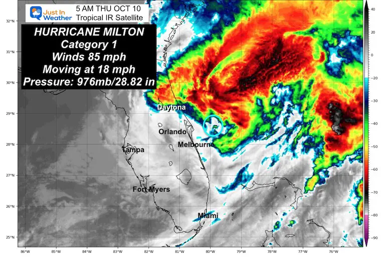
Thursday Morning, October 10 2024

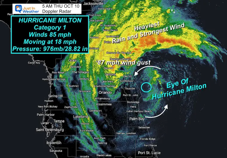
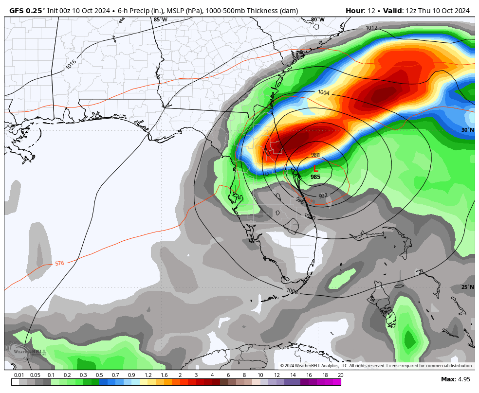
The morning report shows Hurricane Milton as a Category 1 storm back over the Atlantic Ocean with winds of 85 mph. It crossed the entire state of Florida as a Hurricane and was located 10 miles Northeast of Cape Canaveral.

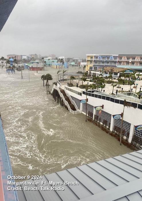
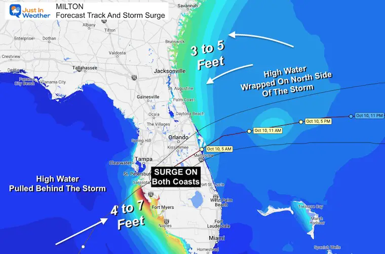
Around 8:30 PM last evening, Hurricane Milton made landfall in Siesta Key, Florida, in the Sarasota area. Early reports show a storm surge of at least 10 Feet and may be higher to the south. On the north side (as we discussed here), the storm track kept Tampa Bay from the surge, and water actually drained out briefly.

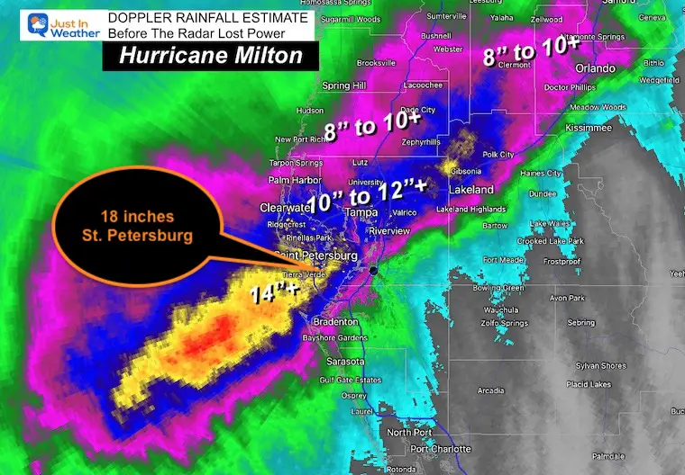
Some of the worst landfalling weather was in St. Petersburg, where over 18 inches of rain fell, and winds of 102 mph were recorded.

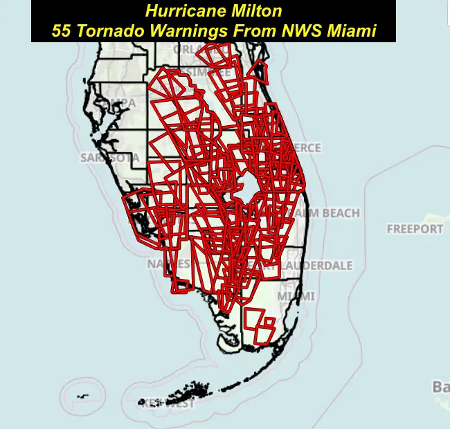
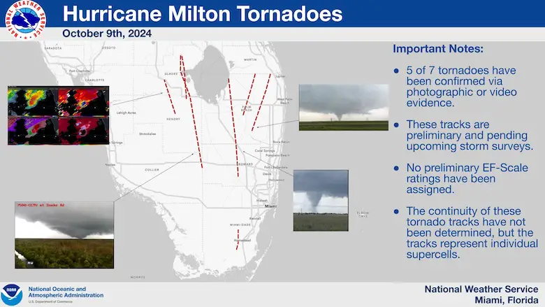
Widespread Destruction: There was a record 133 Tornado Warnings, the most in a single day in Florida.

The roof on Tropicana Field in St. Petersburg, Home of the Tampa Bay Rays baseball team, was blown off.

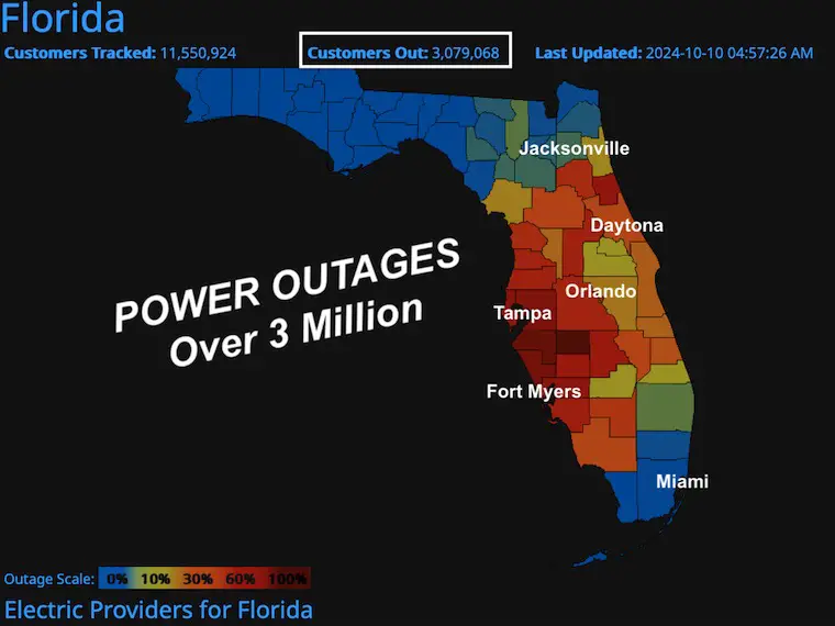
Power is out for over 3 million customers.

Rainfall Exceeded 14 inches along the Gulf Coast north of the eye track.

The true damage will only be known with daylight. Here is the report before sunrise:


Storm Surge Yesterday: Margaritaville On Fort Myers Beach

Flooding in rivers and inland with slow drainage can last one week in parts of Florida.

More videos and reports are below, along with the forecast.

Hurricane Milton Storm Surge Fort Myers


OVERNIGHT: Roof Torn Off Tropicana Field

This was used as a shelter for linemen and first responders.

NWS MIAMI TORNADO RECORD

10/9 – As of 6pm Wednesday

  • 55 Tornado Warnings were issued today solely by NWS Miami.
  • 98 Tornado Warnings issued today by NWS Tampa Bay, NWS Melbourne, and NWS Miami today.
  • (up to 133 as of Thursday morning)
  • At least 9 Confirmed Tornadoes today in our NWS Miami area (Preliminary)

Hurricane Milton Record Tornado Warnings NWS Miami


NWS Miami Tornado Confirmation

Hurricane Milton Hurricane Confirmation NWS Miami


5 AM Doppler Radar

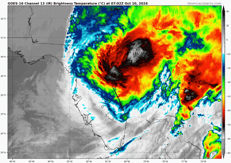
The eye is back offshore east of Titusville.

Heavy rain continues to pummel Daytona Beach and Northeast Florida.

October 10 Hurricane Milton Radar 5 AM


5 AM Tropical Satellite

October 10 Hurricane Milton Satellite 5 AM


Peak Wind Gusts Since Midnight

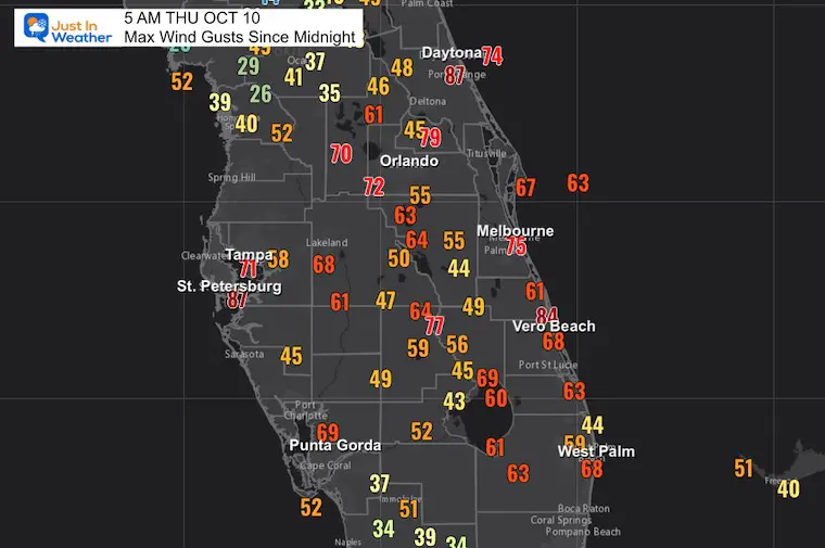
Many weather stations BROKE… So, there may have been higher gusts not recorded.

Orlando and Daytona are experiencing their strongest winds at 5 AM (the time of this report) on the back side of Milton as it moves away.

  • 87 Daytona Beach International Airport
  • 87 mph St. Petersburg (they hit 102 mph yesterday)
  • 84 mph Vero Beach
  • 79 mph Orlando – Sanford Airport
  • 71 mph Tampa
  • 69 mph Punta Gorda
  • 68 mph West Palm Beach

October 10 Hurricane Milton Wind Gusts 5 AM


Rainfall Totals: Doppler Radar Estimate

October 10 Hurricane Milton Doppler Radar Rainfall Estimate


LIVE RADAR Widget


Report

National Hurricane Center SUMMARY OF 5 AM EDT

  • LOCATION…28.5N 80.5W
  • ABOUT 10 MI…15 KM NE OF CAPE CANAVERAL FLORIDA
  • ABOUT 255 MI…410 KM NW OF GREAT ABACO ISLAND
  • MAXIMUM SUSTAINED WINDS…85 MPH…140 KM/H
  • PRESENT MOVEMENT…NE OR 55 DEGREES AT 18 MPH…30 KM/H
  • MINIMUM CENTRAL PRESSURE…976 MB…28.82 INCHES

Tropical IR Satellite Loop

October 10 Hurricane Milton satellite loop

Power Outages:

Over 3 Million Customers/Households or Businesses. This affects even more ‘people.’ This may continue to go up this morning.

October 10 Hurricane Milton Power Outages


Track And Storm Surge Forecast

  • Sebastian Inlet, FL to Altamaha Sound, GA…3-5 ft
  • St. Johns River…2-4 ft
  • Middle of Longboat Key, FL to Bonita Beach, FL…2-4 ft
  • Charlotte Harbor…2-4 ft

October 10 Hurricne Milton Track Forecast


Videos

Reverse Surge…

There was flooding with heavy rain, but this was a result of the wind NORTH of the Eye:

Water Bay Drained Out Of Tampa Bay with wind blowing out to sea. It will return.


Tornados


Just A Taste Of The Mass Destruction


Forecast Animation: GFS Model

October 10 Hurricane Milton Forecast Thursday


SUMMARY OF WATCHES AND WARNINGS IN EFFECT:

A Storm Surge Warning is in effect for…

  • Florida west coast from Bonita Beach northward to Middle of Longboat Key, including Charlotte Harbor
  • Sebastian Inlet Florida to Altamaha Sound Georgia, including the St. Johns River

A Hurricane Warning is in effect for…

  • Florida east coast from the St. Lucie/Martin County Line northward to Ponte Vedra Beach

A Tropical Storm Warning is in effect for…

  • Florida east coast south of the St. Lucie/Martin County Line to the Broward/Palm Beach County Line
  • North of Ponte Vedra Beach Florida to Edisto Beach South Carolina
  • Extreme northwestern Bahamas, including Grand Bahama Island, the Abacos, and Bimini


Recap Of The 2024 Atlantic Tropical Season So Far:

Named Storms

  1. Alberto June 19 to 20; Peaked As Tropical Storm
  2. Beryl June 28  11; Peaked As Cat 5 Hurricane
  3. Chris June 30 to July 1; Peaked As Tropical Storm
  4. Debby August 3 to 9; Peaked as a Category 1 Hurricane
  5. Ernesto August 12 to 20; Peaked As Cat 2 Hurricane
  6. Francine September 9 to 12; Peaked As Cat 2 Hurricane
  7. Gordon September 11 to 17; Tropical Storm
  8. Helen September 24 t0 27; Cat 4 Hurricane. Landfall with 140 mph winds
  9. Joyce September 27 to 30; Tropical Storm
  10. Kirk September 29 to  ; Cat 4 Hurricane : Ocean with 145 mph winds
  11. Leslie October 2 to ; Cat 1 Hurricane
  12. Milton October 5 to

Please share your thoughts and best weather pics/videos, or just keep in touch via social media.


SCHEDULE A WEATHER BASED STEM ASSEMBLY

Severe Weather: Storm Smart October and next spring

Winter Weather FITF (Faith in the Flakes): November To March

Click to see more and send a request for your school.

School Weather Assemblies Storm Smart FITF

ALSO SEE

Equinox NOT Equal Daylight… Yet

September 22 weather Fall Equinox 2024


SECOND OF FOUR FULL SUPERMOONS

Click to see the full report:

September 17 4 supermoons

THANK YOU:

Baltimore Magazine Readers Choice Best Of Baltimore


Maryland Trek 11 Day 7 Completed Sat August 10

We raised OVER $104,000 for Just In Power Kids – AND Still Collecting More

The annual event: Hiking and biking 329 miles in 7 days between The Summit of Wisp to Ocean City.

Each day, we honor a kid and their family’s cancer journey.

Fundraising is for Just In Power Kids: Funding Free Holistic Programs. I never have and never will take a penny. It is all for our nonprofit to operate.

Click here or the image to donate:


RESTATING MY MESSAGE ABOUT DYSLEXIA

I am aware there are some spelling and grammar typos and occasional other glitches. I take responsibility for my mistakes and even the computer glitches I may miss. I have made a few public statements over the years, but if you are new here, you may have missed it: I have dyslexia and found out during my second year at Cornell University. It didn’t stop me from getting my meteorology degree and being the first to get the AMS CBM in the Baltimore/Washington region.

One of my professors told me that I had made it that far without knowing and to not let it be a crutch going forward. That was Mark Wysocki, and he was absolutely correct! I do miss my mistakes in my own proofreading. The autocorrect spell check on my computer sometimes does an injustice to make it worse. I also can make mistakes in forecasting. No one is perfect at predicting the future. All of the maps and information are accurate. The ‘wordy’ stuff can get sticky. 

There has been no editor who can check my work while writing and to have it ready to send out in a newsworthy timeline. Barbara Werner is a member of the web team that helps me maintain this site. She has taken it upon herself to edit typos when she is available. That could be AFTER you read this. I accept this and perhaps proves what you read is really from me… It’s part of my charm. #FITF