


January 6 Weather Some Fog And Clouds Followed By The Warm Up With Rain By The Weekend
Tuesday, January 6, 2026 The storm track has shifted to the north. We are still on the edge, which is why we have areas of fog, and most of the…
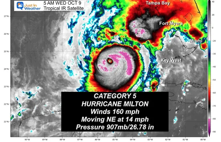
Wednesday Morning, October 9 2024
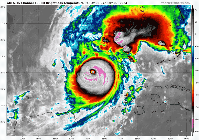
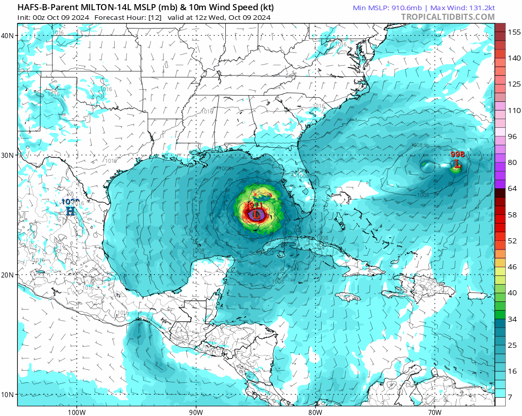
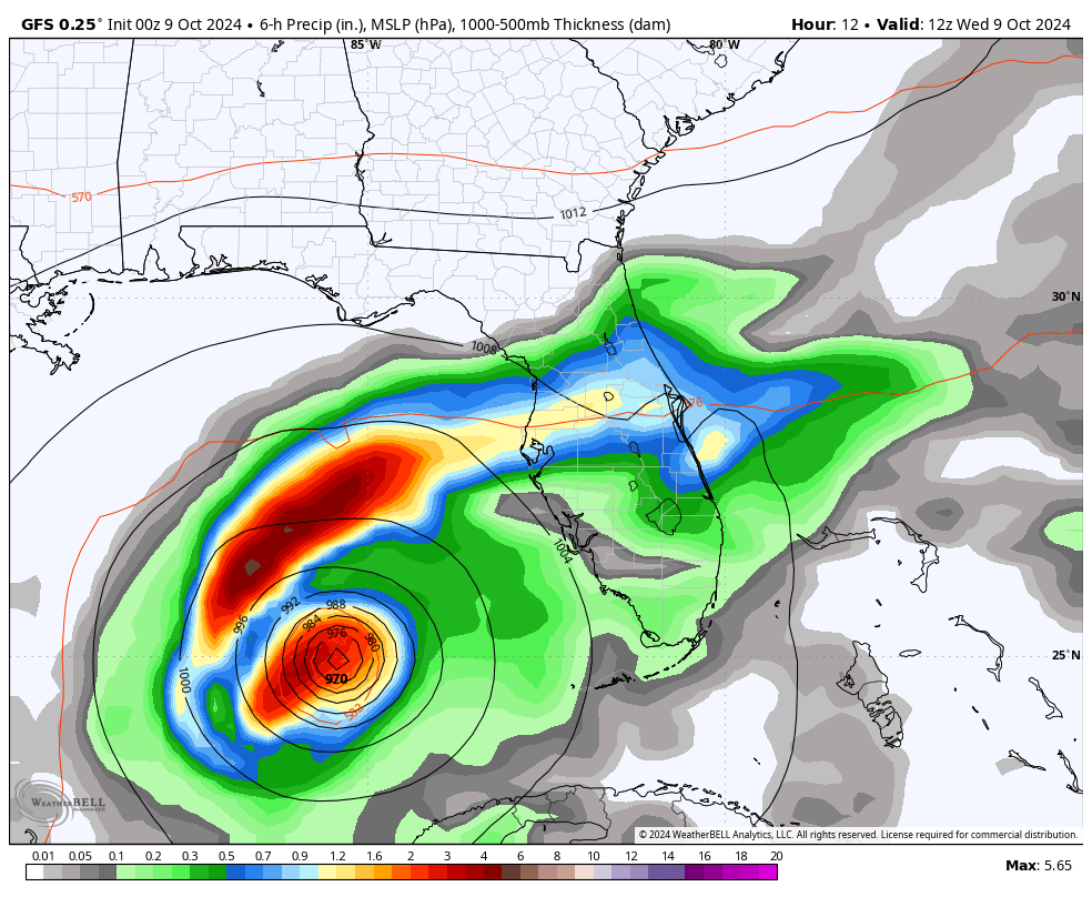
We start the day with this report from the National Hurricane Center at 5 AM EDT: Winds were 160 mph, making this a Category 5 Hurricane. The eye remains sturdy, but we do expect weakening during the day. Regardless of the winds at landfall, the water pushed onshore will carry the wave memory of this peak intensity. The rainfall will expand and maybe exceed forecasts.
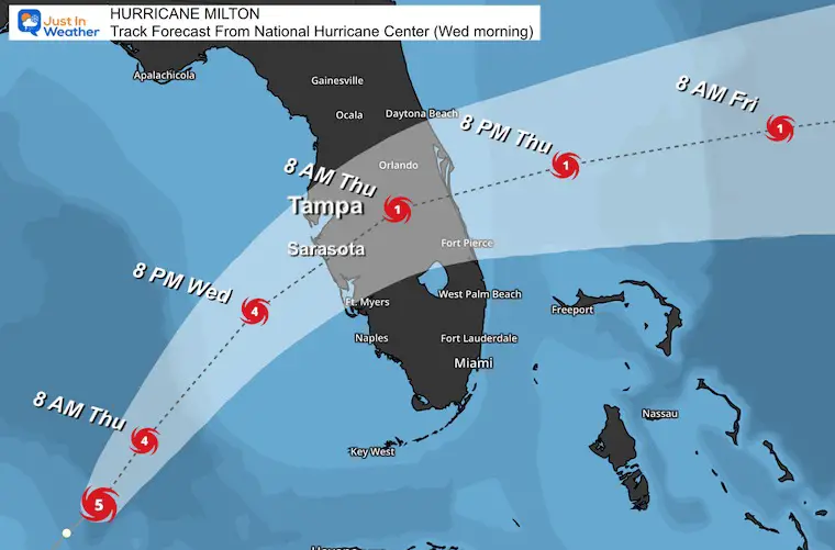
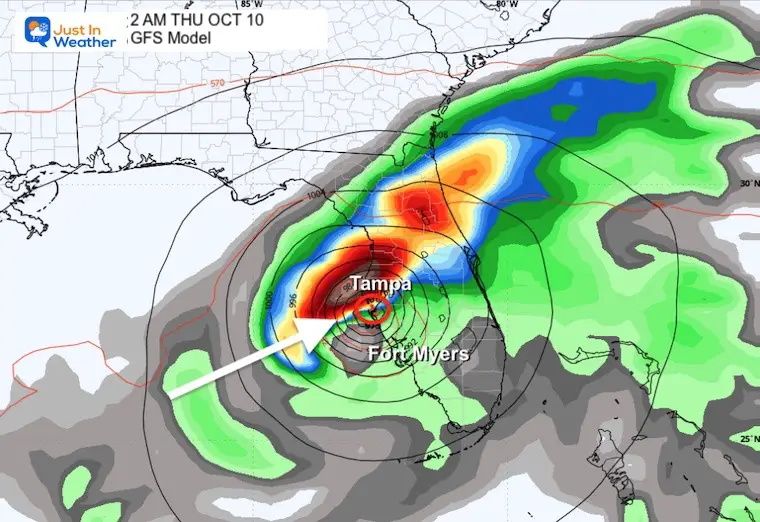
I want to focus on the track’s shift southward. I began showing this yesterday afternoon, and the modeling continued overnight. The newest storm surge maps plot a slightly better set-up for Tampa Bay but worse for Siesta Key, Venice, and southward.
In this report: Satellite Loops, Landfall Maps, Local Storm Surge Plots, Live Radar, New Model Maps, and Warnings.
The eye was 300 miles from Tampa.
Moving Northeast at 14 mph…. It will travel faster as it gets closer.
Milton has been a tightly compact storm, but it will double in size (or more) as it eventually weakens and approaches land later today.
The National Hurricane Center track has plotted landfall about 50 miles south of where it was expected earlier yesterday. The timing is expected after midnight.
Tropical Storm Force Winds may be felt on the coast this morning.
Hyper Local Looks With Surge Heights Below 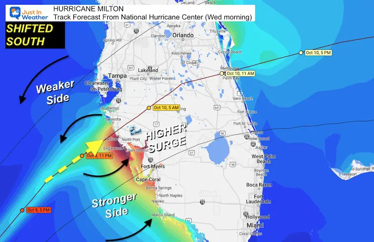
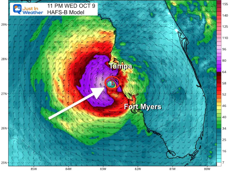
Hurricane Force Winds: Extend 30 miles from the center Tropical Storm Force Winds: Extend 125 miles from the center.
THIS WILL EXPAND FARTHER AS THE THE STORM GETS WEAKER AND CLOSER TO LAND.
Hurricane force winds may carry with the storm all the way to the Atlantic Coast.
Tornadoes are common with landfalling tropical cyclones. This can be hundreds of miles from the center in outer bands and will include much of the State of Florida.
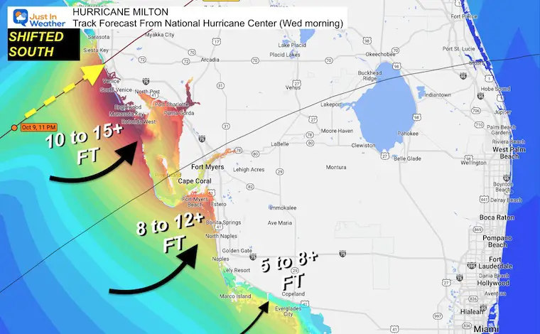
Saltwater flooding is Storm Surge. 6” of water can move a person. 12” of water can move an SUV or Truck. The forecast is 10 to 15 Ft in the worst areas. This will push well inland.
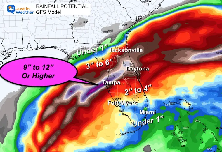
Freshwater flooding is caused by rainfall, which may be up to 3 inches per hour. The forecast has a total of 9 to 12” or higher in the path and north of the eye track. Some of these areas are already 2 feet (24”) above rainfall for the year and have been very wet for the last two weeks.
The National Hurricane Center track has plotted about 50 miles south of where the landfall was expected earlier yesterday. The timing is expected after midnight.
Tropical Storm Force Winds: May be felt on the coast by later this morning.
Landfall MAY BE Near Venice 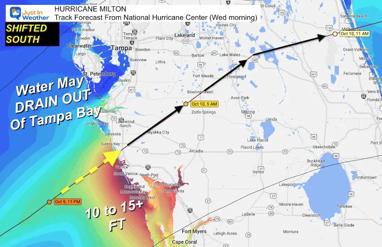
Areas just north of the eye wall may get an initial surge, then water could drain OUT OF Tampa Bay as the eye passes:
This has been doing a good job leading the pack with the track adjustment.
This is a low end conservative estimation. 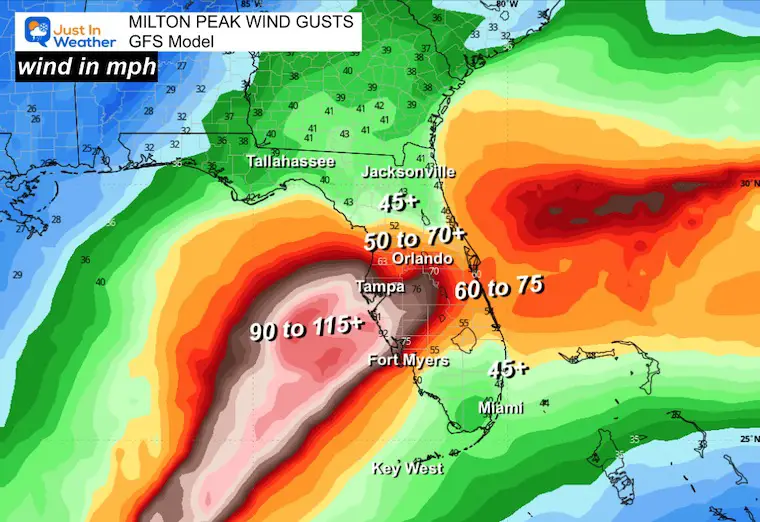
The Freshwater Flooding is likely 9 to 12 inches+ along and just north of the path.
Models have a tough time with tropical rain bands and often results end up higher.
SUMMARY OF WATCHES AND WARNINGS IN EFFECT:
A Storm Surge Warning is in effect for…
A Hurricane Warning is in effect for…
A Storm Surge Watch is in effect for…
A Hurricane Watch is in effect for…
A Tropical Storm Warning is in effect for…
A Tropical Storm Watch is in effect for…
Named Storms
Severe Weather: Storm Smart October and next spring Winter Weather FITF (Faith in the Flakes): November To March Click to see more and send a request for your school. 
The annual event: Hiking and biking 329 miles in 7 days between The Summit of Wisp to Ocean City.
Each day, we honor a kid and their family’s cancer journey.
Fundraising is for Just In Power Kids: Funding Free Holistic Programs. I never have and never will take a penny. It is all for our nonprofit to operate.
Click here or the image to donate:

I am aware there are some spelling and grammar typos and occasional other glitches. I take responsibility for my mistakes and even the computer glitches I may miss. I have made a few public statements over the years, but if you are new here, you may have missed it: I have dyslexia and found out during my second year at Cornell University. It didn’t stop me from getting my meteorology degree and being the first to get the AMS CBM in the Baltimore/Washington region. One of my professors told me that I had made it that far without knowing and to not let it be a crutch going forward. That was Mark Wysocki, and he was absolutely correct! I do miss my mistakes in my own proofreading. The autocorrect spell check on my computer sometimes does an injustice to make it worse. I also can make mistakes in forecasting. No one is perfect at predicting the future. All of the maps and information are accurate. The ‘wordy’ stuff can get sticky. There has been no editor who can check my work while writing and to have it ready to send out in a newsworthy timeline. Barbara Werner is a member of the web team that helps me maintain this site. She has taken it upon herself to edit typos when she is available. That could be AFTER you read this. I accept this and perhaps proves what you read is really from me… It’s part of my charm. #FITF