


January 2 Weather Still Cold This Weekend With A Warm Up Next Week
Friday, January 2, 2026 After the New Year's Day Morning Snow Squall, the cold air mass has been firmly in place. One more system passed through overnight with flurries and…
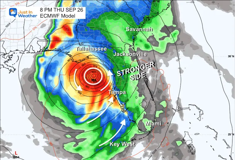
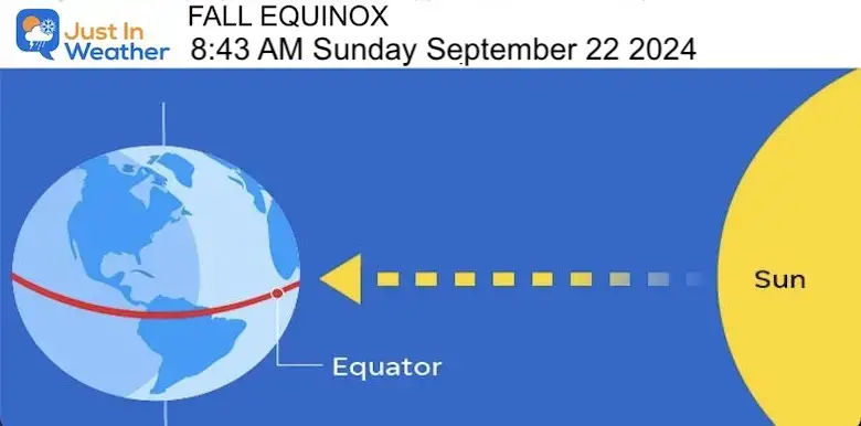
Thursday, September 26 2024
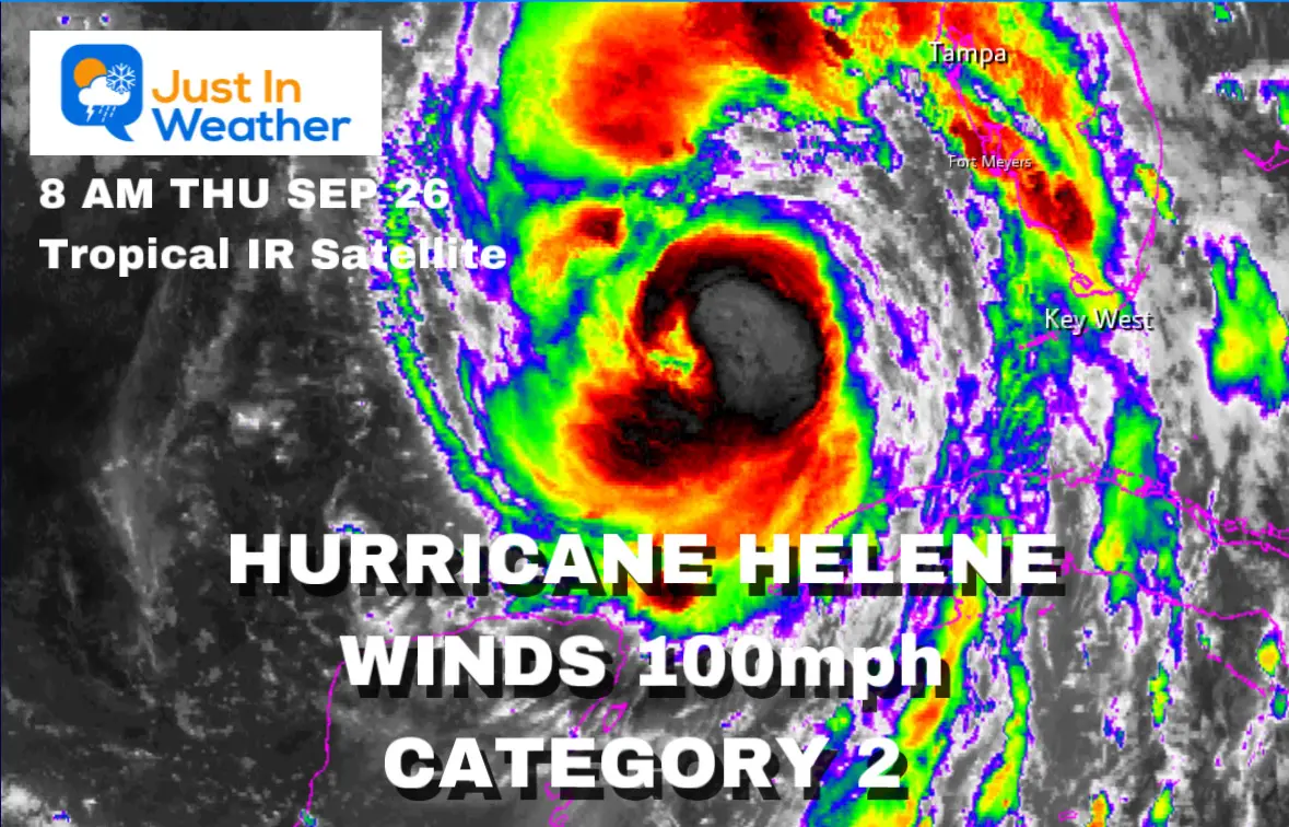
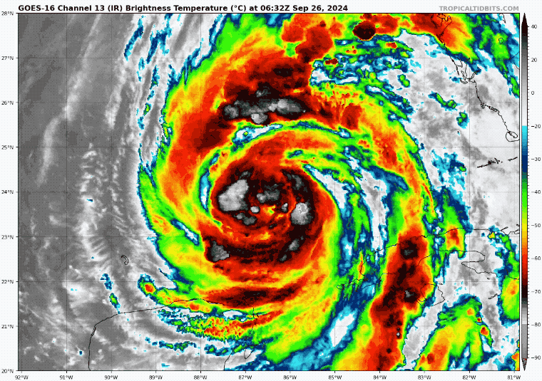
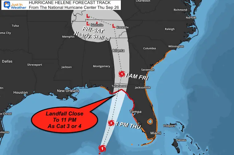
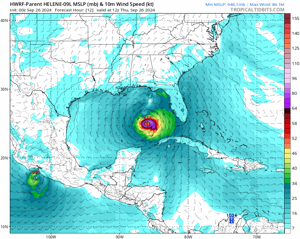
Hurricane Helene is strengthening over the Gulf of Mexico, and today is the day it is expected to build up quickly and then speed up in forward motion before making landfall tonight. A State of Emergency is still in effect for much of Florida and into Georgia. Evacuations have been underway. Today will be the waiting game before landfall tonight.
At Category 2, as of the 8 am advisory this morning, the top sustained winds are 100 mph, within 60 miles of the center. This is a large storm, however, with tropical storm winds reaching 345 miles from the center. That makes it nearly 700 miles wide! The storm has the potential for various types of damage, including heavy rain leading to flooding, wind damage, multiple tornadoes, and storm surge.
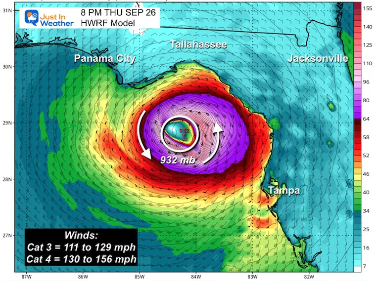
Helene is expected to reach Category 3 as it tracks over warmer pockets of water (86ºF to 89ºF) this afternoon. The brief outlook for a Category 4 has been lowered, but it will still be a Major Hurricane with winds over 110 mph. Regardless of the wind speed, it will be devastating to a large area.
This report has the latest maps and forecasts from this morning. Also, New Watches and Warnings.
Also, see the interactive Windy Widget below.
The most destructive part of this system may be the salt water pushing onshore ahead of landfall. The National Hurricane Center is now predicting a high storm surge of 15 ft to 20 ft for a large area north of Tampa. But most of the Gulf Coast of Florida will have salt water flooding on the strong side of the storm.
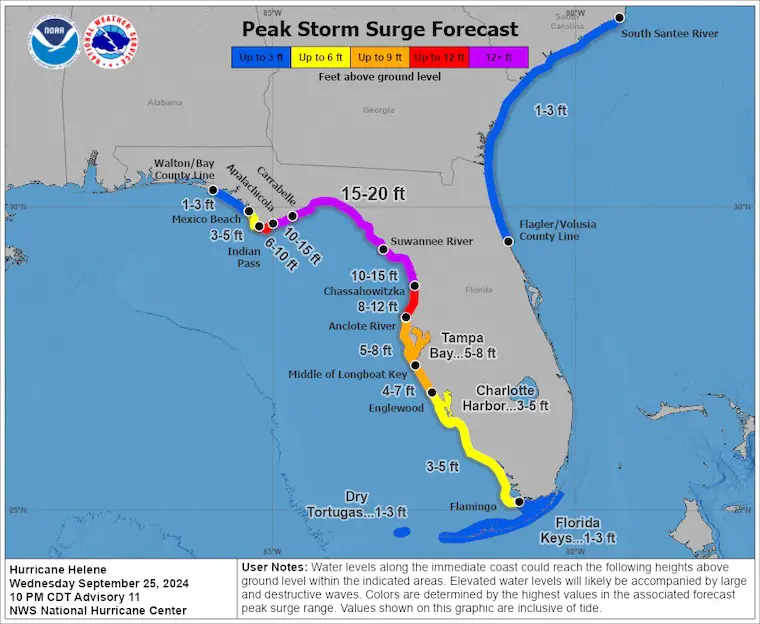
A Storm Surge Warning is in effect for…
* Mexico Beach eastward and southward to Flamingo
* Tampa Bay
* Charlotte Harbor
A Hurricane Warning is in effect for…
* Anclote River to Mexico Beach
A Hurricane Watch is in effect for…
* Englewood to Anclote River, including Tampa Bay
A Tropical Storm Warning is in effect for…
* Florida Keys, including the Dry Tortugas
* Flamingo to Anclote River, including Tampa Bay
* West of Mexico Beach to the Okaloosa/Walton County Line
* Flamingo northward to Little River Inlet
* Lake Okeechobee
* Cuban provinces of Artemisa, Pinar del Rio, and the Isle of Youth
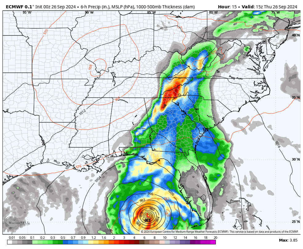
Updated Thursday Morning

This is before the worst of the system and when the impacts and potential damage begins.
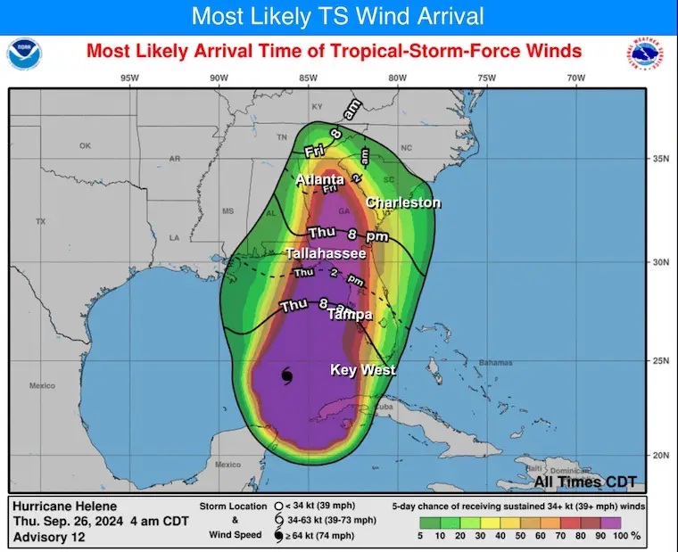
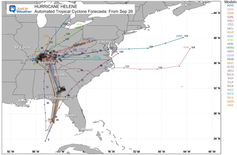
This Low is still expected to track well inland to the Northwest and nearly stall.
The rain bands reach the Mid-Atlantic, then the system cuts off.
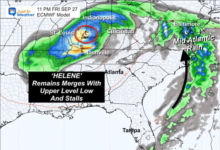
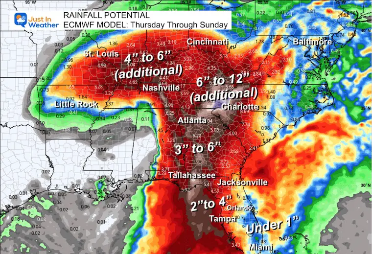
Note that some additional rainfall has already occurred, especially between Atlanta and Nashville, from a different system over the past few days.
Named Storms
Severe Weather: Storm Smart October and next spring
Winter Weather FITF (Faith in the Flakes): November To March
Click to see more and send a request for your school.

The annual event: Hiking and biking 329 miles in 7 days between The Summit of Wisp to Ocean City.
Each day, we honor a kid and their family’s cancer journey.
Fundraising is for Just In Power Kids: Funding Free Holistic Programs. I never have and never will take a penny. It is all for our nonprofit to operate.
Click here or the image to donate:

I am aware there are some spelling and grammar typos and occasional other glitches. I take responsibility for my mistakes and even the computer glitches I may miss. I have made a few public statements over the years, but if you are new here, you may have missed it: I have dyslexia and found out during my second year at Cornell University. It didn’t stop me from getting my meteorology degree and being the first to get the AMS CBM in the Baltimore/Washington region.
One of my professors told me that I had made it that far without knowing and to not let it be a crutch going forward. That was Mark Wysocki, and he was absolutely correct! I do miss my mistakes in my own proofreading. The autocorrect spell check on my computer sometimes does an injustice to make it worse. I also can make mistakes in forecasting. No one is perfect at predicting the future. All of the maps and information are accurate. The ‘wordy’ stuff can get sticky.
There has been no editor who can check my work while writing and to have it ready to send out in a newsworthy timeline. Barbara Werner is a member of the web team that helps me maintain this site. She has taken it upon herself to edit typos when she is available. That could be AFTER you read this. I accept this and perhaps proves what you read is really from me… It’s part of my charm. #FITF