


January 2 Weather Still Cold This Weekend With A Warm Up Next Week
Friday, January 2, 2026 After the New Year's Day Morning Snow Squall, the cold air mass has been firmly in place. One more system passed through overnight with flurries and…
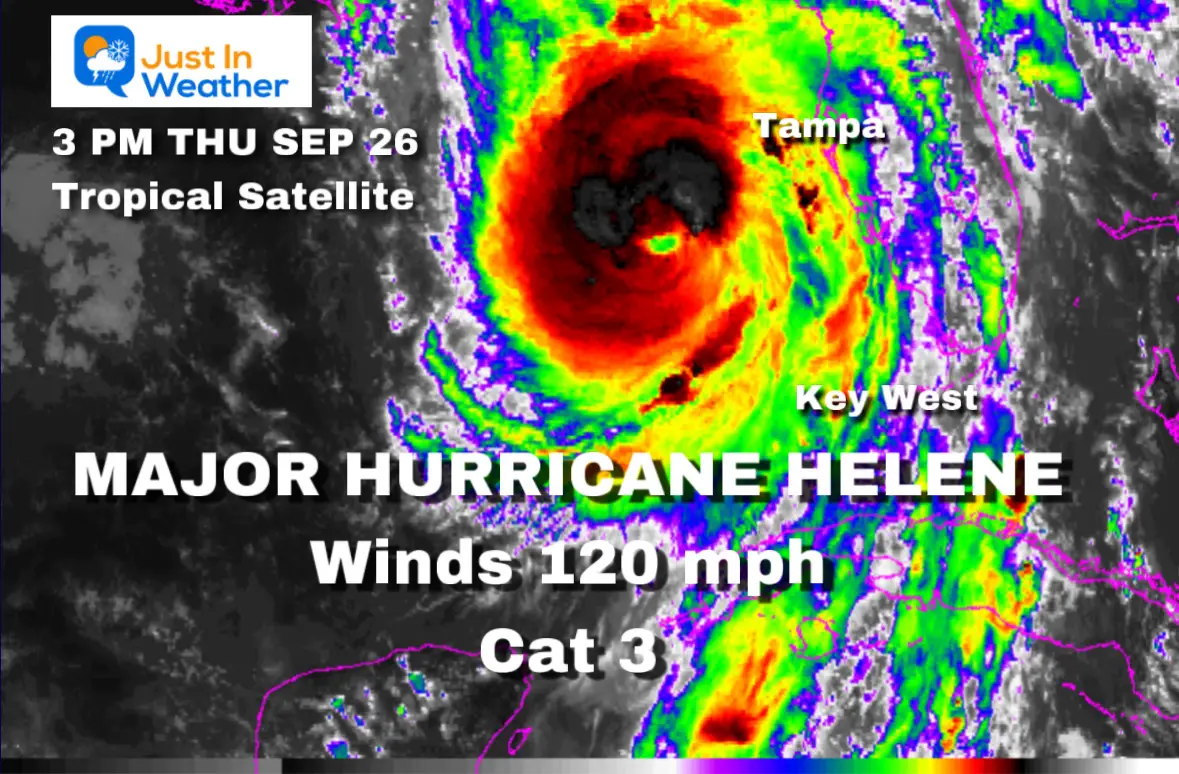
Thursday, September 26 2024
UPDATE AT 3PM
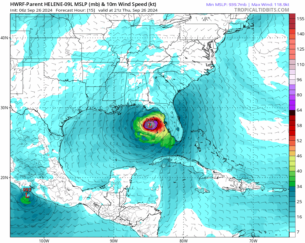
US Air Force Reconnaissance found 120 mph winds This makes it Major Hurricane Helene at Category 3
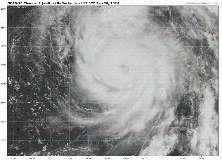
Click this image for the newer report
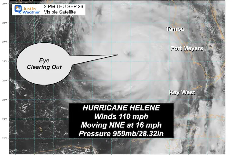
At the top end of Category 2, we are looking at Hurricane Helene with 110 mph winds and a central pressure of 959 mb. This is the growth that was expected, and by the next scheduled advisory at 5 p.m., it will likely be a major hurricane Category 3.
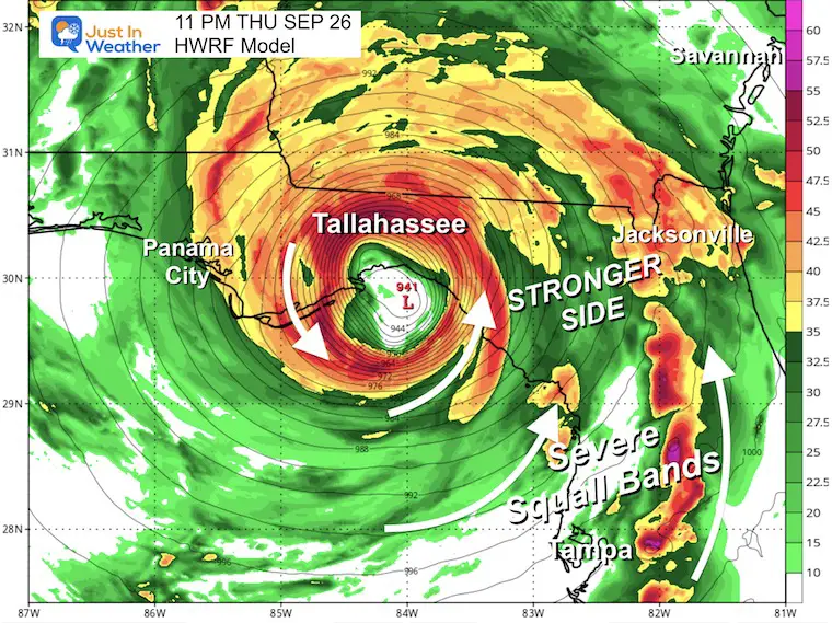
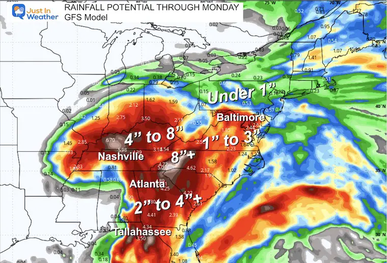
The track is still expected to make landfall tonight close to 11 PM and then track almost directly over Tallahassee, FL, and Atlanta, GA, on Friday morning. More on the rest of the path below.
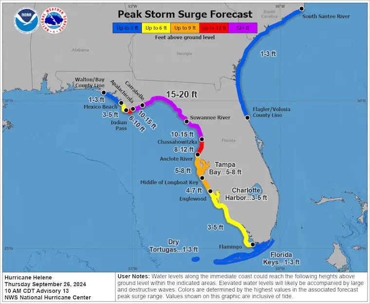
This is one of the largest storms in this region on record. Hurricane-force winds reach 60 miles of the center. The tropical storm force winds reach 345 miles from the center. At nearly 700 miles wide, the impact will be far-reaching. There is a focus on the landfall and the incredible storm surge forecast up to 20 Ft across the Big Bend of Florida. The additional conditions and damage may include flooding from heavy rain, wind damage, and multiple tornadoes.
This update includes the storm conditions, images, forecasts, AND impact later this weekend in the Mid-Atlantic when the remains try to reach the East Coast.
Also, see the interactive Windy Widget below.
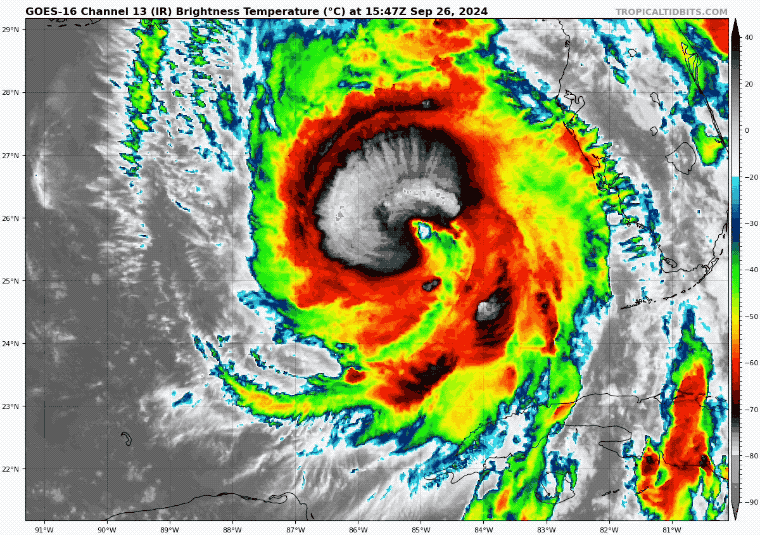
We can see the development of deep convection (high-top thunderstorms) wrapping around the center. This helps to define the eye wall where the strongest winds are located AND clear out the center eye as well.
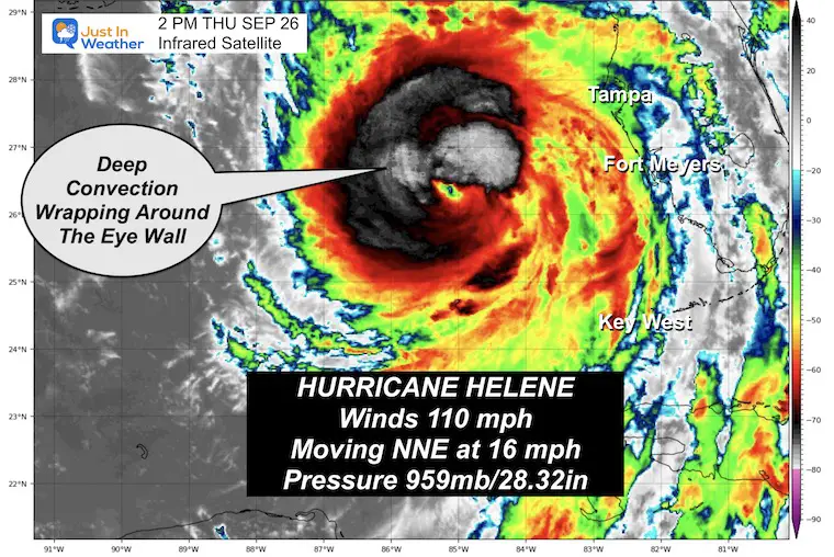
Tracking over warmer pockets of water (86ºF to 89ºF), the added danger is that this may be in an intensifying phase as it makes landfall. That makes it more dangerous and able to hold better circulation farther inland.
The most destructive part of this system may be the salt water pushing onshore ahead of landfall. The National Hurricane Center is now predicting a high storm surge of 15 ft to 20 ft for a large area north of Tampa. But most of the Gulf Coast of Florida will have salt water flooding on the strong side of the storm.
OFFICIAL NHC MAPS THEN MODEL MODELS BELOW
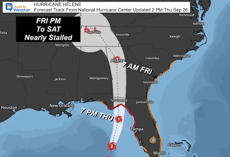
This has been very consistent, showing landfall and tracking near Tallahassee. This area has never recorded a direct hurricane eye passing over. It is subject to extensive damage and power outages that may last weeks.
Category 3 = 111 to 130 mph
Category 4 = 131 to 156 mph
A Storm Surge Warning is in effect for…
A Hurricane Warning is in effect for…
A Hurricane Watch is in effect for…
A Tropical Storm Warning is in effect for…
Updated Thursday Afternoon
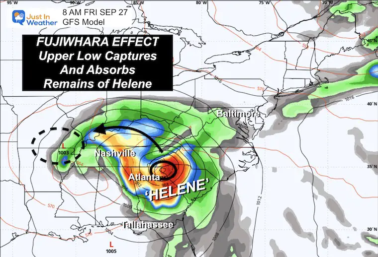
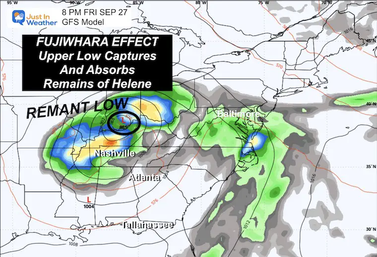
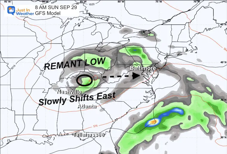
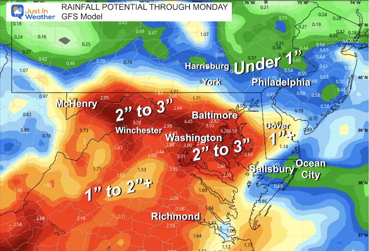
There is a noticeable cluster north of Nashville and then a shift towards Maryland. It will not be tropical at that point but will be plotted below.
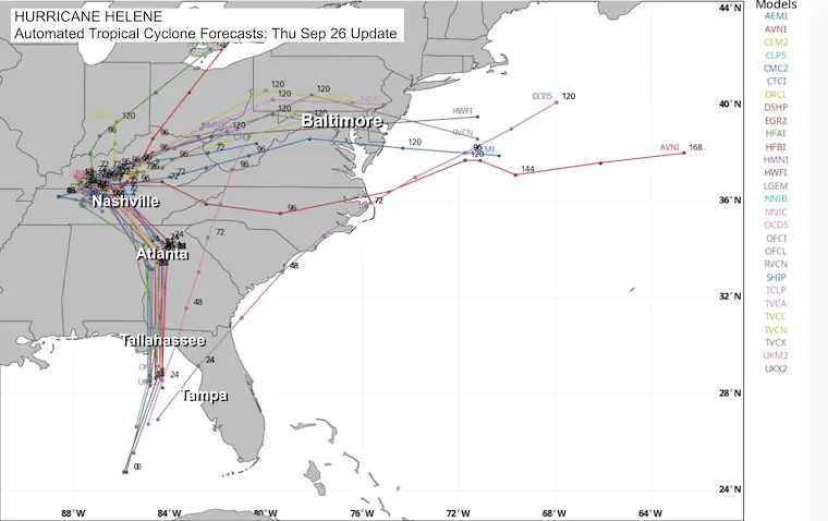
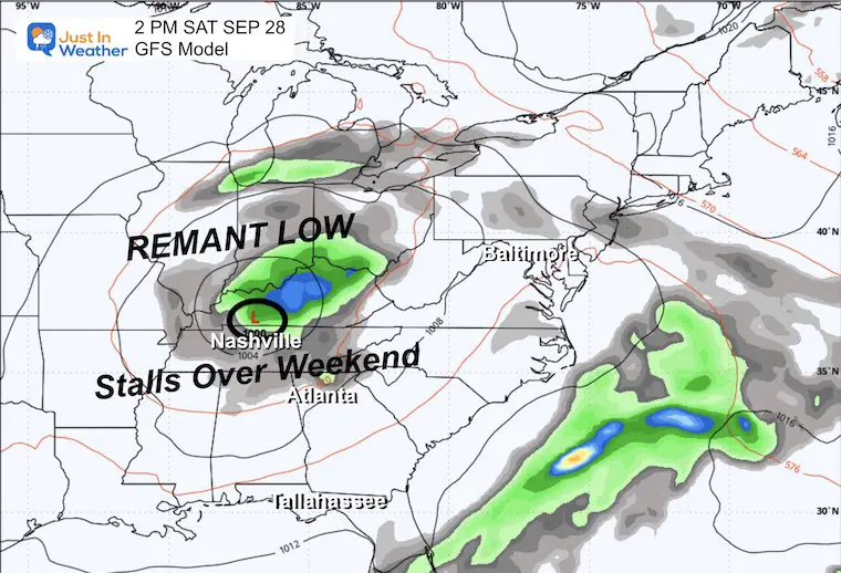
This Low is still expected to track well inland to the Northwest and nearly stall when merging with an upper-level Low. This will shift slowly east and may stall again over the Mid-Atlantic on Sunday.
Low Pressure is expected to be tracking through Northern Georgia and making the turn Northwest farther inland and away from the East Coast.
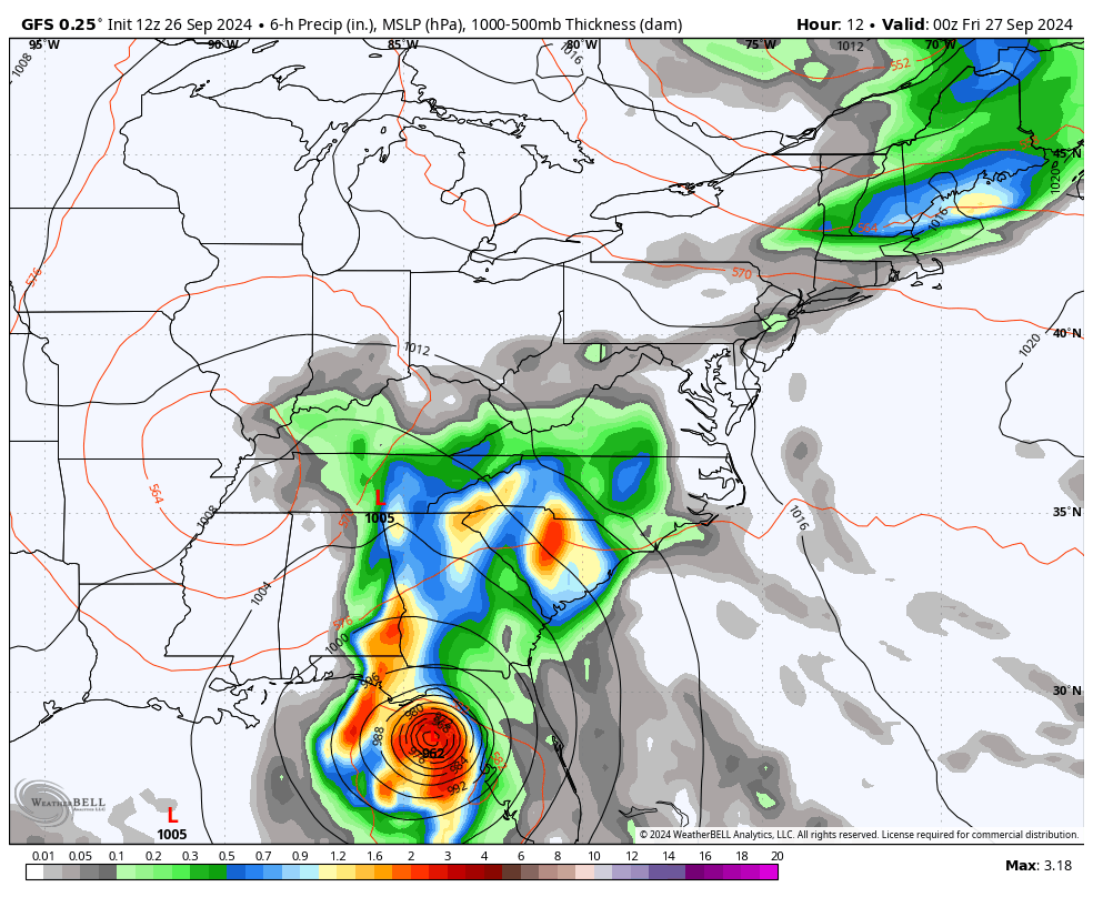
The rain bands reach the Mid-Atlantic, and then the system cuts off.
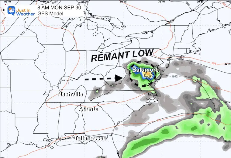
The upper-level Low remains nearly stalled. The East Coast will be warm and humid, with only showers that may pop in the afternoon and evening.
Rain in the Mid-Atlantic as the upper-level Low passes over Maryland.
Rain may redevelop over Maryland.
There will be rain on Friday and again on Sunday. As of now, Saturday is looking warm and humid, but showers will be limited to scattered pop-ups later in the day.
Severe Weather: Storm Smart October and next spring
Winter Weather FITF (Faith in the Flakes): November To March
Click to see more and send a request for your school.

The annual event: Hiking and biking 329 miles in 7 days between The Summit of Wisp to Ocean City.
Each day, we honor a kid and their family’s cancer journey.
Fundraising is for Just In Power Kids: Funding Free Holistic Programs. I never have and never will take a penny. It is all for our nonprofit to operate.
Click here or the image to donate:

I am aware there are some spelling and grammar typos and occasional other glitches. I take responsibility for my mistakes and even the computer glitches I may miss. I have made a few public statements over the years, but if you are new here, you may have missed it: I have dyslexia and found out during my second year at Cornell University. It didn’t stop me from getting my meteorology degree and being the first to get the AMS CBM in the Baltimore/Washington region.
One of my professors told me that I had made it that far without knowing and to not let it be a crutch going forward. That was Mark Wysocki, and he was absolutely correct! I do miss my mistakes in my own proofreading. The autocorrect spell check on my computer sometimes does an injustice to make it worse. I also can make mistakes in forecasting. No one is perfect at predicting the future. All of the maps and information are accurate. The ‘wordy’ stuff can get sticky.
There has been no editor who can check my work while writing and to have it ready to send out in a newsworthy timeline. Barbara Werner is a member of the web team that helps me maintain this site. She has taken it upon herself to edit typos when she is available. That could be AFTER you read this. I accept this and perhaps proves what you read is really from me… It’s part of my charm. #FITF