


January 2 Weather Still Cold This Weekend With A Warm Up Next Week
Friday, January 2, 2026 After the New Year's Day Morning Snow Squall, the cold air mass has been firmly in place. One more system passed through overnight with flurries and…
Wednesday September 25, 2024
Morning Report
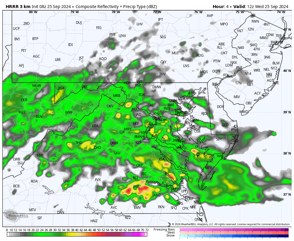
This wet weather pattern continues. The roads are likely wet, and the fields are damp or soggy for after-school sports. There will be more steady rain today, with a mix of drizzle and fog. There will again be heavier thunderstorms in the mountains.
Tomorrow should give us a break with a brief warm-up, and then more rain arrives on Friday. This will be from Helene after making landfall in Florida, but we will remain very far away from that storm. It will help influence more showers each day into next week.
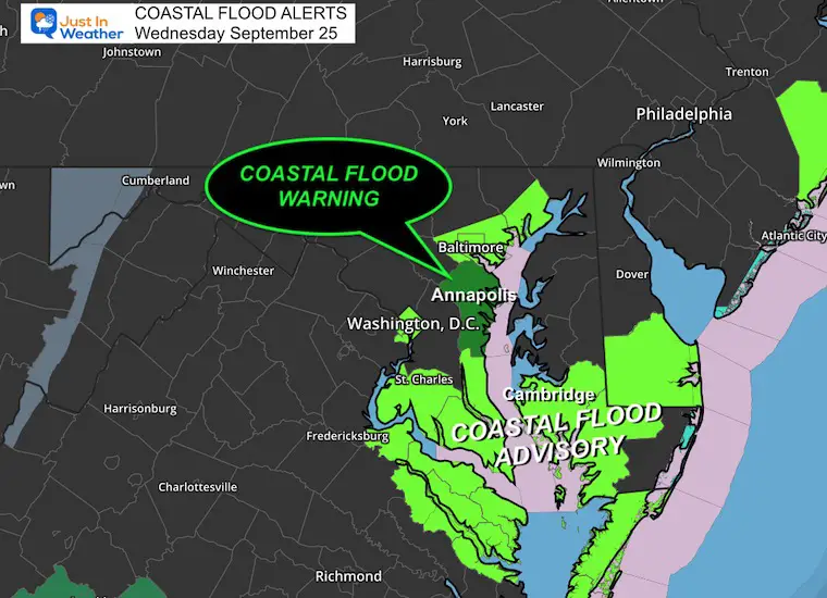
The higher water continues with the Easterly winds raising water with each high tide.
Annapolis High Tides:
11:44 AM
THU 1:10 AM; 12:53 PM
Cambridge High Tides:
10:32 AM; 11:49 PM
Much of the Eastern US is under the influence of low clouds, drizzle, and showers. The steadier rain and thunderstorms will be more active in the mountains and try to spread east later today.
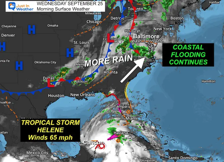
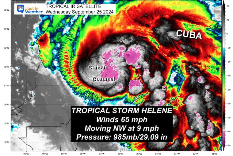
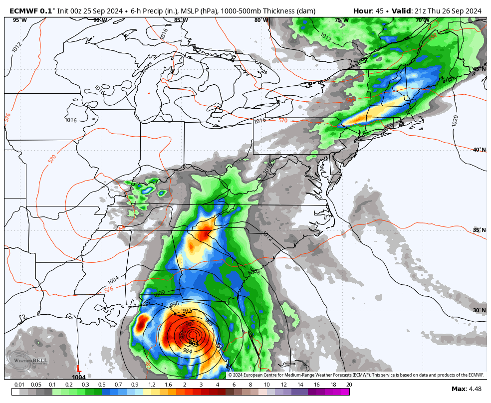
This morning, winds were 65 mph, and it was located near Cozumel and Cancun in Mexico. Once entering the Gulf of Mexico, it is expected to become a hurricane later today. Then, it is expected to rapidly develop into a Category 3 before landfall in Florida tomorrow night.
New Hurricane Warnings plus a State of Emergency is in place for Florida and Georgia.
Click here or these images for the full morning report on this storm.
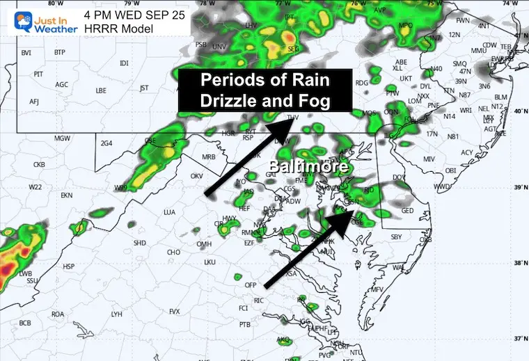
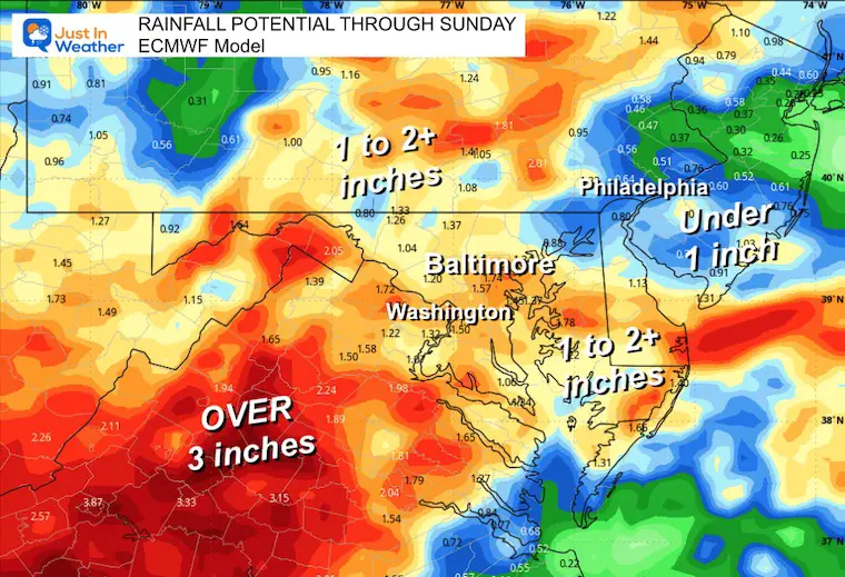
Periods of rain will continue, and likely more than shown here. At times, steady rain will pulse with periods of drizzle and fog.
EXTENDED FORECAST BELOW
TODAY September 25
Sunrise at 6:58 AM
Sunset at 6:58 PM
Normal Low in Baltimore: 55ºF
Record 35ºF in 1963
Normal High in Baltimore: 76ºF
Record 97ºF 1970
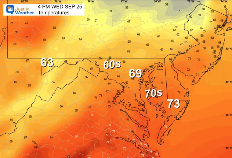
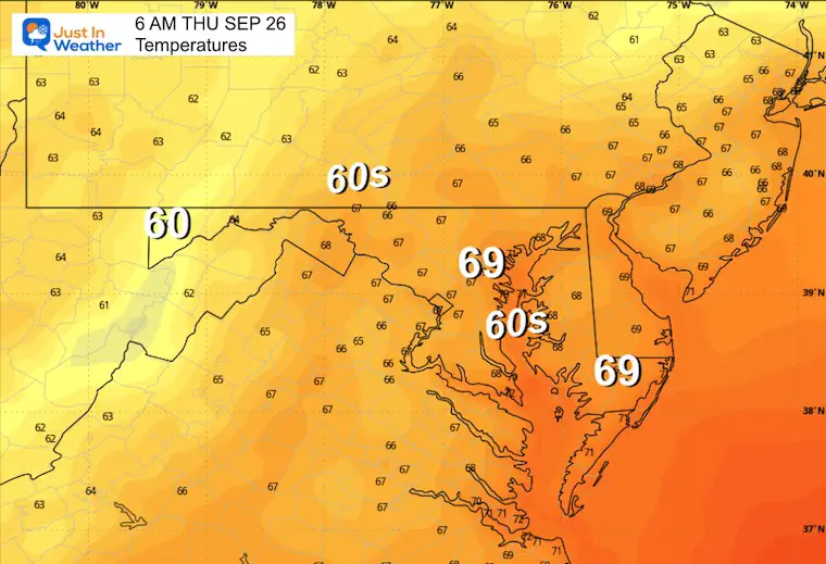
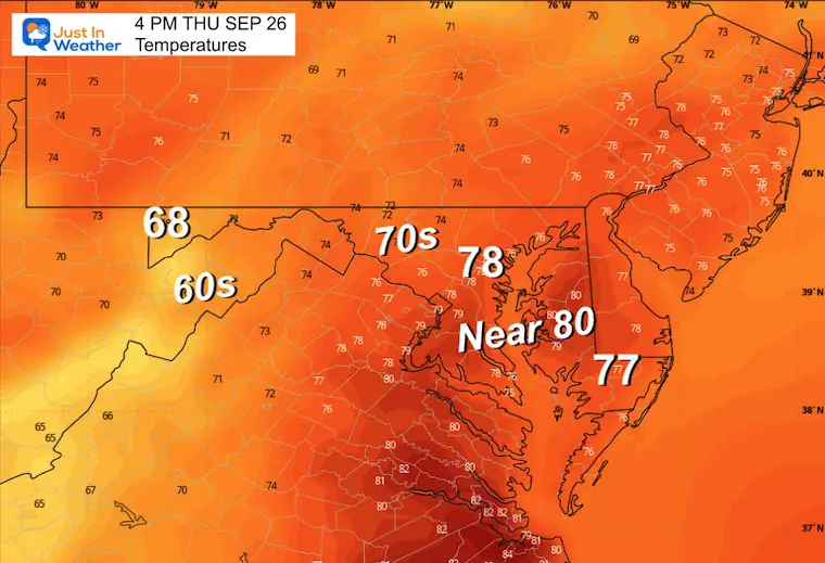
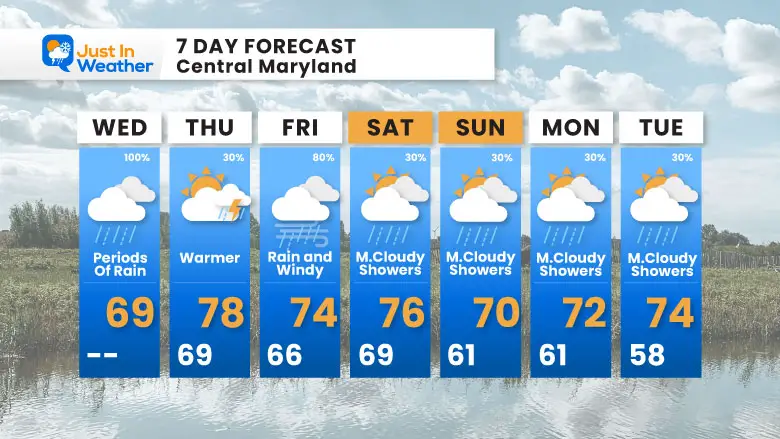
We may get a break on Thursday, which can allow temps to rise into the upper 70s or near 80ºF.
Thursday Through Saturday
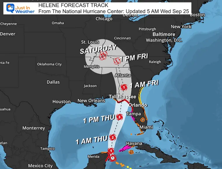
Here is a wide-view look at what is expected to be Major Hurricane Helene hitting Florida tomorrow night with winds of over 110 mph. The upper-level system I mentioned yesterday will help pull the Low North and Northwest into the Ohio Valley.
While the main storm will miss us, the surge of a plume of rain will arrive in the Mid-Atlantic by Friday afternoon. Then, a stalled pattern will keep an East Wind with showers in place for many days to follow.
The rain from Helene that pushes up the East Coast will reach Maryland. It is important to note that the remnant Low of Helene will be somewhere in the Ohio River Valley.
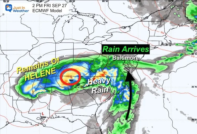
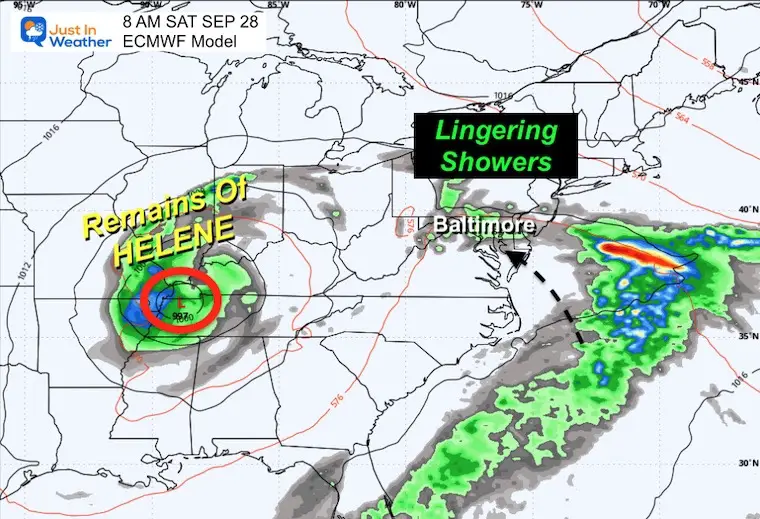
The remnant Low of Helene will be stuck in the Midwest, and we will remain with an unsettled, damp pattern. Showers and an easterly wind will continue for a few days.
There may be more rain in addition to this into early next week.
One warmer day near 80ºF on Thursday, then we need to pay close attention to some tropical rain showers that may arrive Friday into Saturday.
A sustained cloudy, cool, and wet pattern with ‘showers’, not steady rain, is expected to last into next week.
Severe Weather: Storm Smart October and next spring
Winter Weather FITF (Faith in the Flakes): November To March
Click to see more and send a request for your school.

The annual event: Hiking and biking 329 miles in 7 days between The Summit of Wisp to Ocean City.
Each day, we honor a kid and their family’s cancer journey.
Fundraising is for Just In Power Kids: Funding Free Holistic Programs. I never have and never will take a penny. It is all for our nonprofit to operate.
Click here or the image to donate:

I am aware there are some spelling and grammar typos and occasional other glitches. I take responsibility for my mistakes and even the computer glitches I may miss. I have made a few public statements over the years, but if you are new here, you may have missed it: I have dyslexia and found out during my second year at Cornell University. It didn’t stop me from getting my meteorology degree and being the first to get the AMS CBM in the Baltimore/Washington region.
One of my professors told me that I had made it that far without knowing and to not let it be a crutch going forward. That was Mark Wysocki, and he was absolutely correct! I do miss my mistakes in my own proofreading. The autocorrect spell check on my computer sometimes does an injustice to make it worse. I also can make mistakes in forecasting. No one is perfect at predicting the future. All of the maps and information are accurate. The ‘wordy’ stuff can get sticky.
There has been no editor who can check my work while writing and to have it ready to send out in a newsworthy timeline. Barbara Werner is a member of the web team that helps me maintain this site. She has taken it upon herself to edit typos when she is available. That could be AFTER you read this. I accept this and perhaps proves what you read is really from me… It’s part of my charm. #FITF