


Winter Weather Advisory Sunday As Snowfall In Two Parts Affecting Two Different Areas
Saturday Evening Update January 17 2026 One thing I carry after all of my years of forecasting: If one model does a really good job in an active pattern, then…
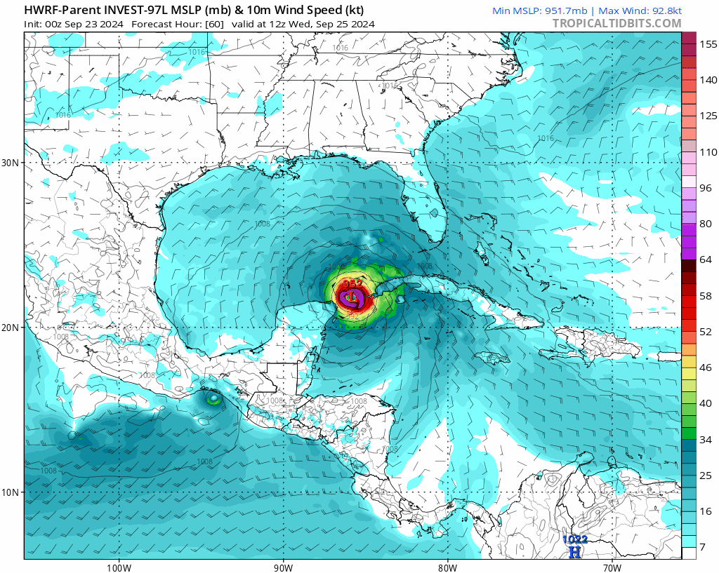
September 23 2024
Monday Morning
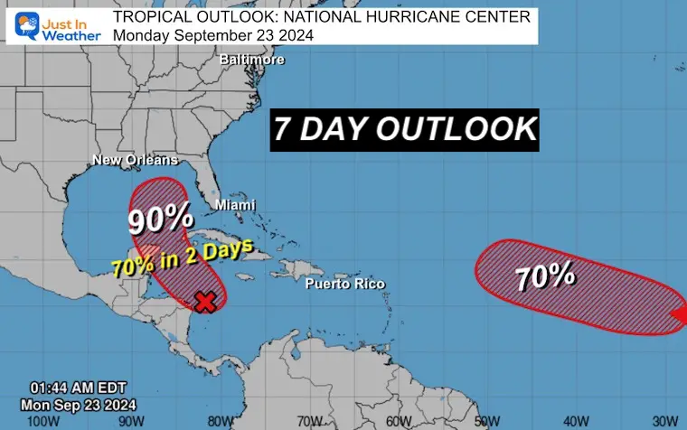
The tropical Atlantic appears to be trying to pulse with activity one more time as we begin Fall. The broad area of Low Pressure in the Northwest Caribbean to the Central Gulf of Mexico is our main interest. The National Hurricane Center has increased the likelihood of development to 90% in the next 7 days. More importantly is the next 2 days with a chance of up to 70%. The forecast outlook below has multiple models shifting the focus farther west into the central US and away from the East Coast.
The storm has not formed yet. When a central Low Pressure is identified, the time and location are critical to lock in on a more refined forecast.
Another area of high interest may also develop in the next week. But that is farther out in the ocean, with little threat to land.
The next two names on the list are Helene and Isaac.
See the interactive Windy Widget at the bottom of this post after the compute model maps.
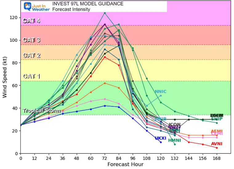
A few regions are being tracked, but the red-shaded area is the one we are concerned with. Reminder that this is the 7-Day outlook. I’ve added the 2-Day Potential for the closer system. This may organize to have 39 mph winds and get a name by Wednesday.
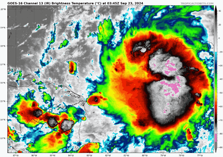
Water Temperatures are in the upper 80s, which supports development if the upper-level winds cooperate.
There will be a storm named Helene this week, and a good chance for Isaac as well.
Last week, we watched a strong low-pressure system off the coast of South Carolina that was expected to become Helene but did not. It did have 50 mph winds and 20 inches of rainfall in coastal North Carolina, but it did not have a true tropical structure.
This new area is different as it is farther south and over very warm water. It has a better chance to become a true tropical structure with a central warm core.
Named Storms
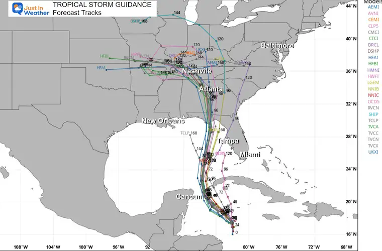
Yesterday I showed a focus on the American GFS Model towards the East Coast and the European ECMWF Model pushing North into the Central US.. The collection of models now agrees with the ECWMF, and that will be my focus here.
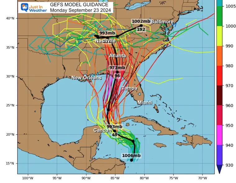
The very warm water and supportive upper-level winds now push a lot of guidance to make this storm a Category 3 Hurricane or Stronger at landfall.
Reminder, this is the model that had a similar solution yesterday so it seems to have a better handle as of now.
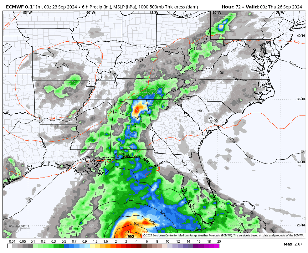
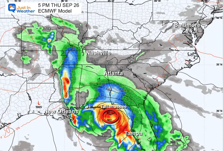
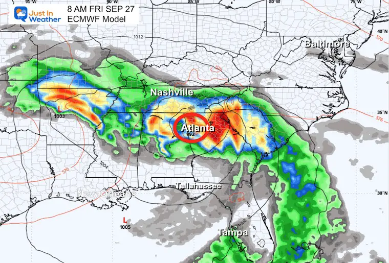
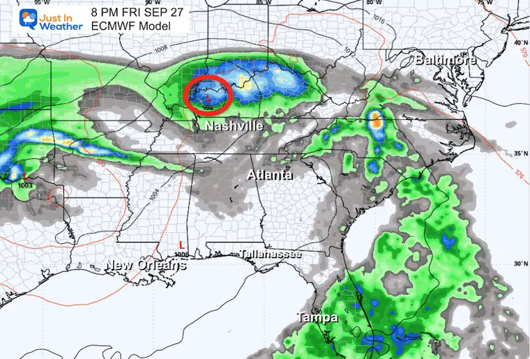
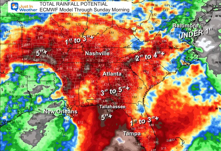
This takes a lot of the rain away from the East Coast and pushes a broad area of 3 or more inches across the Southeast US to Central Mississippi and Ohio River Valleys.
Use the button to scroll to Wednesday, when this storm may take form near Cancun and enter the Gulf of Mexico.
Severe Weather: Storm Smart October and next spring
Winter Weather FITF (Faith in the Flakes): November To March
Click to see more and send a request for your school.

The annual event: Hiking and biking 329 miles in 7 days between The Summit of Wisp to Ocean City.
Each day, we honor a kid and their family’s cancer journey.
Fundraising is for Just In Power Kids: Funding Free Holistic Programs. I never have and never will take a penny. It is all for our nonprofit to operate.
Click here or the image to donate:

I am aware there are some spelling and grammar typos and occasional other glitches. I take responsibility for my mistakes and even the computer glitches I may miss. I have made a few public statements over the years, but if you are new here, you may have missed it: I have dyslexia and found out during my second year at Cornell University. It didn’t stop me from getting my meteorology degree and being the first to get the AMS CBM in the Baltimore/Washington region.
One of my professors told me that I had made it that far without knowing and to not let it be a crutch going forward. That was Mark Wysocki, and he was absolutely correct! I do miss my mistakes in my own proofreading. The autocorrect spell check on my computer sometimes does an injustice to make it worse. I also can make mistakes in forecasting. No one is perfect at predicting the future. All of the maps and information are accurate. The ‘wordy’ stuff can get sticky.
There has been no editor who can check my work while writing and to have it ready to send out in a newsworthy timeline. Barbara Werner is a member of the web team that helps me maintain this site. She has taken it upon herself to edit typos when she is available. That could be AFTER you read this. I accept this and perhaps proves what you read is really from me… It’s part of my charm. #FITF