


Winter Weather Advisory Sunday As Snowfall In Two Parts Affecting Two Different Areas
Saturday Evening Update January 17 2026 One thing I carry after all of my years of forecasting: If one model does a really good job in an active pattern, then…
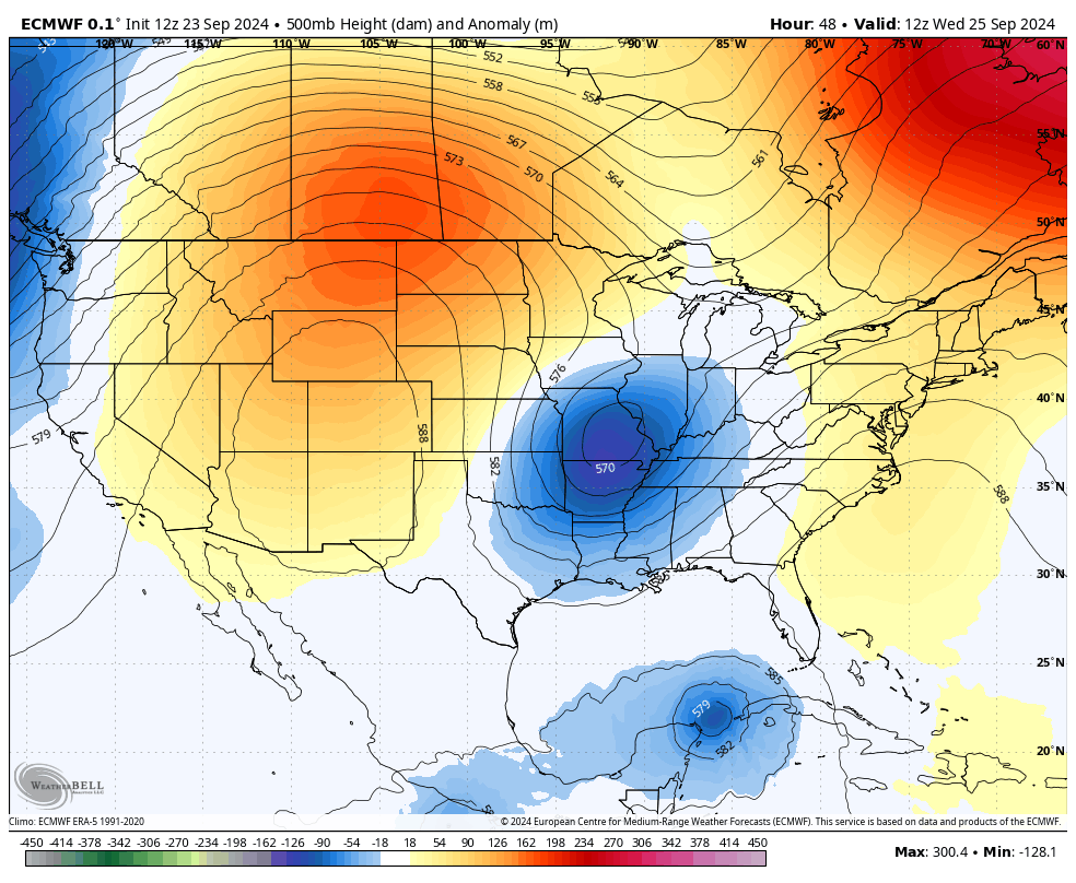
September 23, 2024
Monday Night
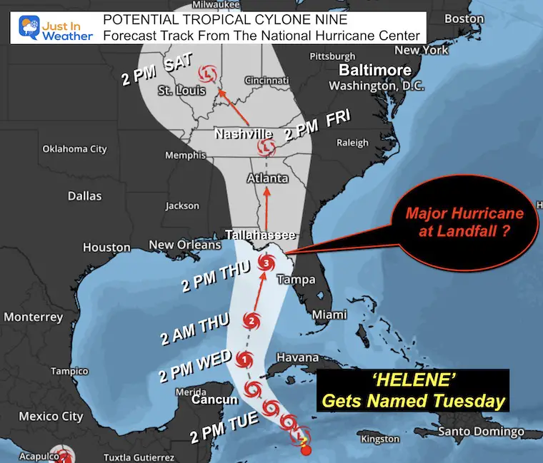
Florida has declared a State of Emergency ahead of what may be a landfalling Major Hurricane on Thursday.
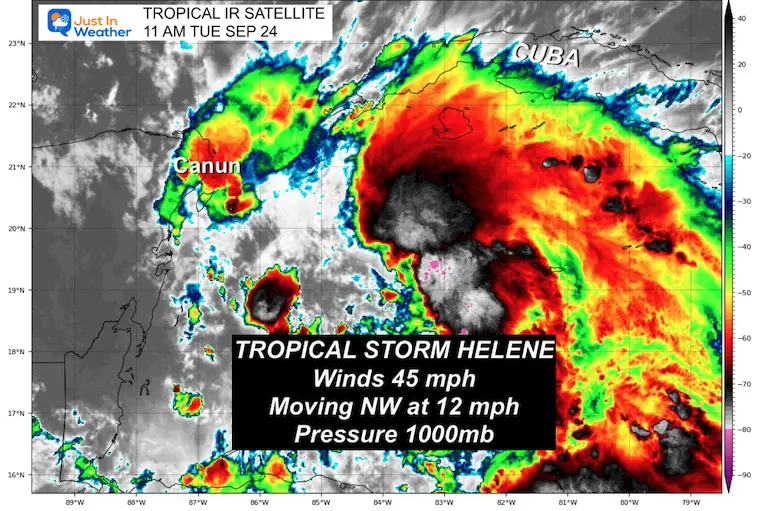
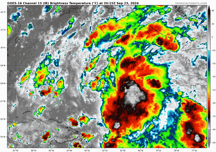
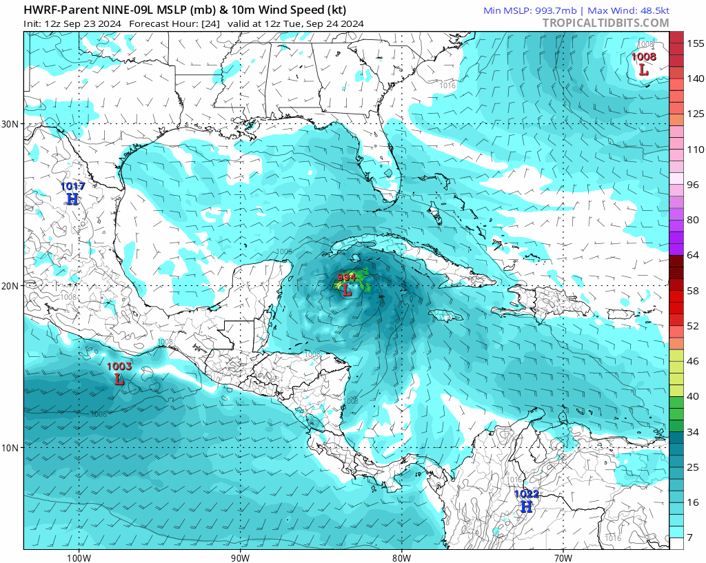
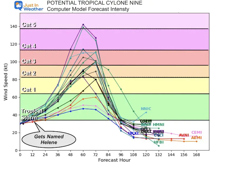
A developing storm in the Northwest Caribbean is getting a little better organized. With winds of 35 mph, it is currently tagged as Potential Tropical Cyclone Nine. If the center becomes more sturdy, with winds above 39 mph, it will be upgraded to Tropical Storm Helene.
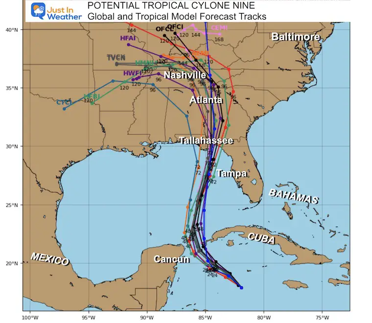
Although the storm has not formed yet, models have a better handle on it, and this is reflected in more agreement with the forecast.
One big concern is the warm water of 86ºF to 89ºF in the forecast path. This increases the likelihood of this becoming a major hurricane at Category 3 or higher with winds OVER 110 mph.
There is also some adjustment to the track, intensity, and forward speed.
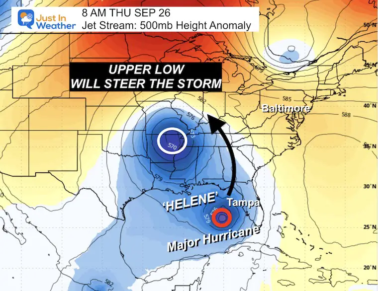
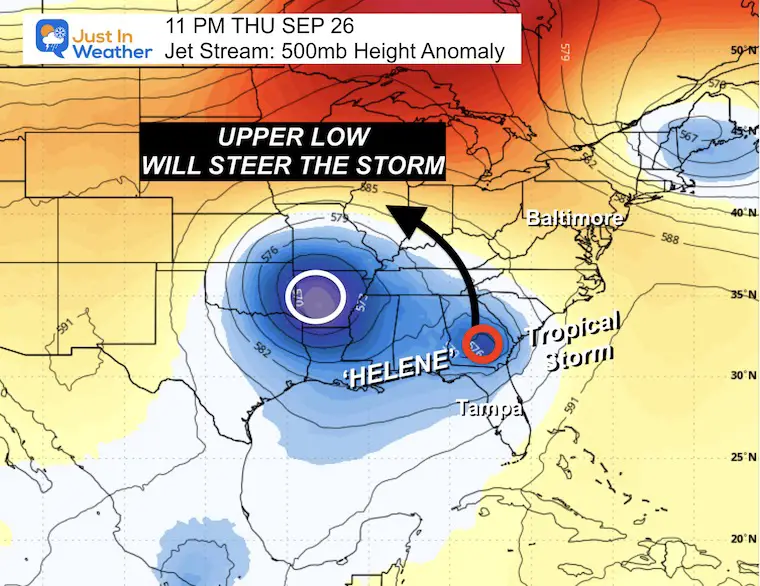
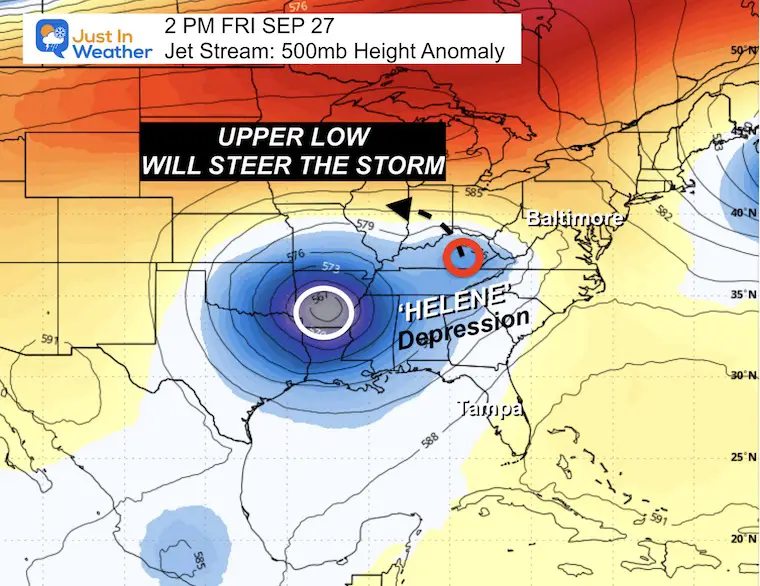
Below, I will show the steering mechanism that will capture Future Helene. An upper-level Low will capture it to help speed up the landfall and then steer it inland. After hitting Florida, it may miss the East Coast and turn into The Ohio Valley.
Also, see the interactive Windy Widget at the bottom of this post after the computer model maps.
Updated maps, watches data, and full forecast
Named Storms
The reason for this track and curve inland is shown below.
At this time, the wind forecast is suggested to be over 100 knots or 115 mph. That would be Category 3.
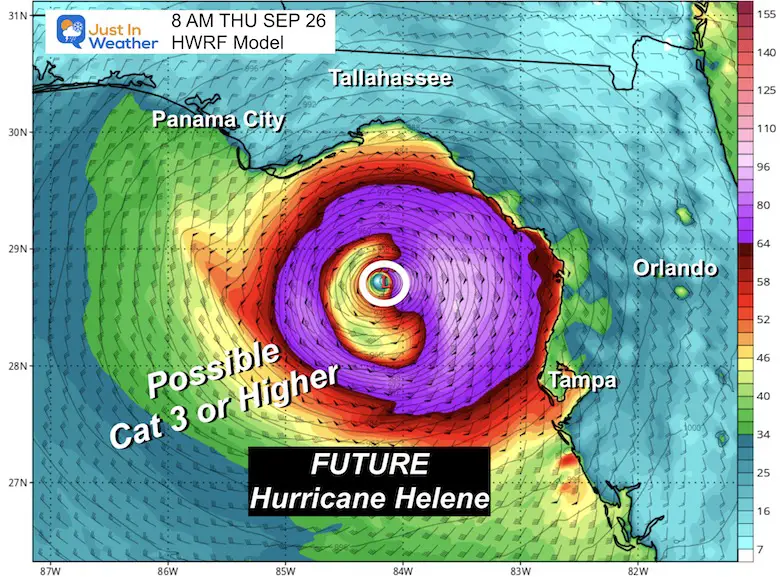
Many models have the strength in Category 3 or 4 at landfall on Thursday.
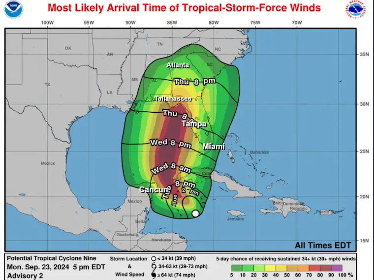
At or above 39 mph
Rainfall: 3 to 6 inches with up to 10 inches near the landfall path.
Storm Surge: Expected 1 to 3 Ft in the Florida Keys. This could push to 10 Ft near landfall north of Tampa, but the entire Gulf Coast of Florida will be affected.
Here is the European ECMWF Model, which was the first to have a good handle on this track. The reason is at the Jet Stream level. As this trough drops into the Southeast US and closes off, the circulation will help speed up the future hurricane for an earlier landfall. This will then capture it, pulling it North and THEN Northwest into the Ohio Valley. This is known as the Fujiwara Effect when one larger system causes a smaller one to orbit or swing around it. While heavy rain bands may reach the coastal Carolinas, the main storm will make the turn in Georgia farther inland.
Wednesday Morning Through Saturday Morning
The peak intensity of the hurricane, while over water, is expected to landfall by midday.
Tracking into Georgia and weakening to a Tropical Storm. It will be turning North then Northwest, away from the East Coast.
The remnant Tropical Depression will lose identity as the energy gets absorbed into the Closed Upper-Level Low.
If this verifies, it may have a repeating impact on Atmospheric Memory into the winter season worth studying.
Use the button to scroll to Wednesday, when this storm may take form near Cancun and enter the Gulf of Mexico.
A Hurricane Watch is in effect for…
* Cabo Catoche to Tulum, Mexico
* Cuban province of Pinar del Rio
A Tropical Storm Warning is in effect for…
* Grand Cayman
* Rio Lagartos to Tulum, Mexico
* Cuban provinces of Artemisa, Pinar del Rio, and the Isle of Youth
A Tropical Storm Watch is in effect for…
* Dry Tortugas
* Lower Keys south of the Seven Mile Bridge
Severe Weather: Storm Smart October and next spring
Winter Weather FITF (Faith in the Flakes): November To March
Click to see more and send a request for your school.

The annual event: Hiking and biking 329 miles in 7 days between The Summit of Wisp to Ocean City.
Each day, we honor a kid and their family’s cancer journey.
Fundraising is for Just In Power Kids: Funding Free Holistic Programs. I never have and never will take a penny. It is all for our nonprofit to operate.
Click here or the image to donate:

I am aware there are some spelling and grammar typos and occasional other glitches. I take responsibility for my mistakes and even the computer glitches I may miss. I have made a few public statements over the years, but if you are new here, you may have missed it: I have dyslexia and found out during my second year at Cornell University. It didn’t stop me from getting my meteorology degree and being the first to get the AMS CBM in the Baltimore/Washington region.
One of my professors told me that I had made it that far without knowing and to not let it be a crutch going forward. That was Mark Wysocki, and he was absolutely correct! I do miss my mistakes in my own proofreading. The autocorrect spell check on my computer sometimes does an injustice to make it worse. I also can make mistakes in forecasting. No one is perfect at predicting the future. All of the maps and information are accurate. The ‘wordy’ stuff can get sticky.
There has been no editor who can check my work while writing and to have it ready to send out in a newsworthy timeline. Barbara Werner is a member of the web team that helps me maintain this site. She has taken it upon herself to edit typos when she is available. That could be AFTER you read this. I accept this and perhaps proves what you read is really from me… It’s part of my charm. #FITF