September 1 Weather Still Humid With Late Storms South Then Clearing And Cooler Labor Day
Sunday, September 1 2024
Morning Report
It is a new month, and we are about to get a new air mass! By definition, this is the start of The Meteorological Fall Season. The data is clustered into three complete month blocks for simplistic organization. It will feel like a new season starting tomorrow, Labor Day.
Recap: August in Baltimore High Temperatures Totals
- 100s = 2
- 90s = 7
- 80s = 18
- 70s = 4
This Morning: The air is still thick and muggy. The high humidity is the same old air mass, and it is about to get pushed out of here.
The system that will arrive includes two frontal boundaries. The first may produce spotty showers but is not well organized. The second stronger cold front will arrive tonight. By that time, the energy is expected to shift farther south. Southeast Virginia and Southern Maryland to the beaches have the best chance for strong to severe storms between sunset and midnight.
The new Air Mass will arrive Labor Day with sunshine and a cooler wind from the North. A pre-Fall chill will be noticeable much of the work week ahead.
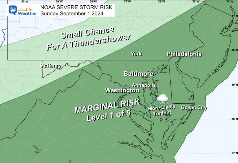
NOAA Severe Storm Risk
The Level 1 Marginal Risk in place is ‘LOW.’ Some thunderstorms may pop up that the radar simulations are not showing. However, my analysis of the timing and energy (shown below) signals the best chance will be across southern Maryland to the beaches tonight between sunset and midnight.
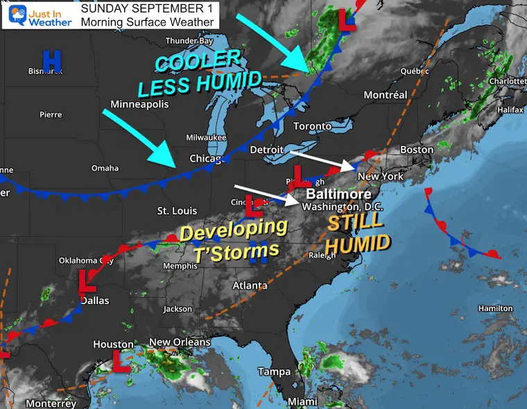
Morning Surface Weather
The warm and humid air is still with us, which may translate to low clouds and some drizzle. A few spotty showers have set up from the mountains to southern Pennsylvania.
There are two fronts we will be dealing with today. The first stationary front will get a move on, and the second cold front will have a firm direction heading our way behind it. I have low confidence in the model simulations as recently, we have seen more activity than they suggest. I will show the best solution below, but please use it as a gauge, not a promise.
High Pressure in North Dakota is the core of the next air mass that will bring cooler and less humid air from Canada our way for much of the week ahead.
LIVE RADAR And LIGHTNING WIDGET
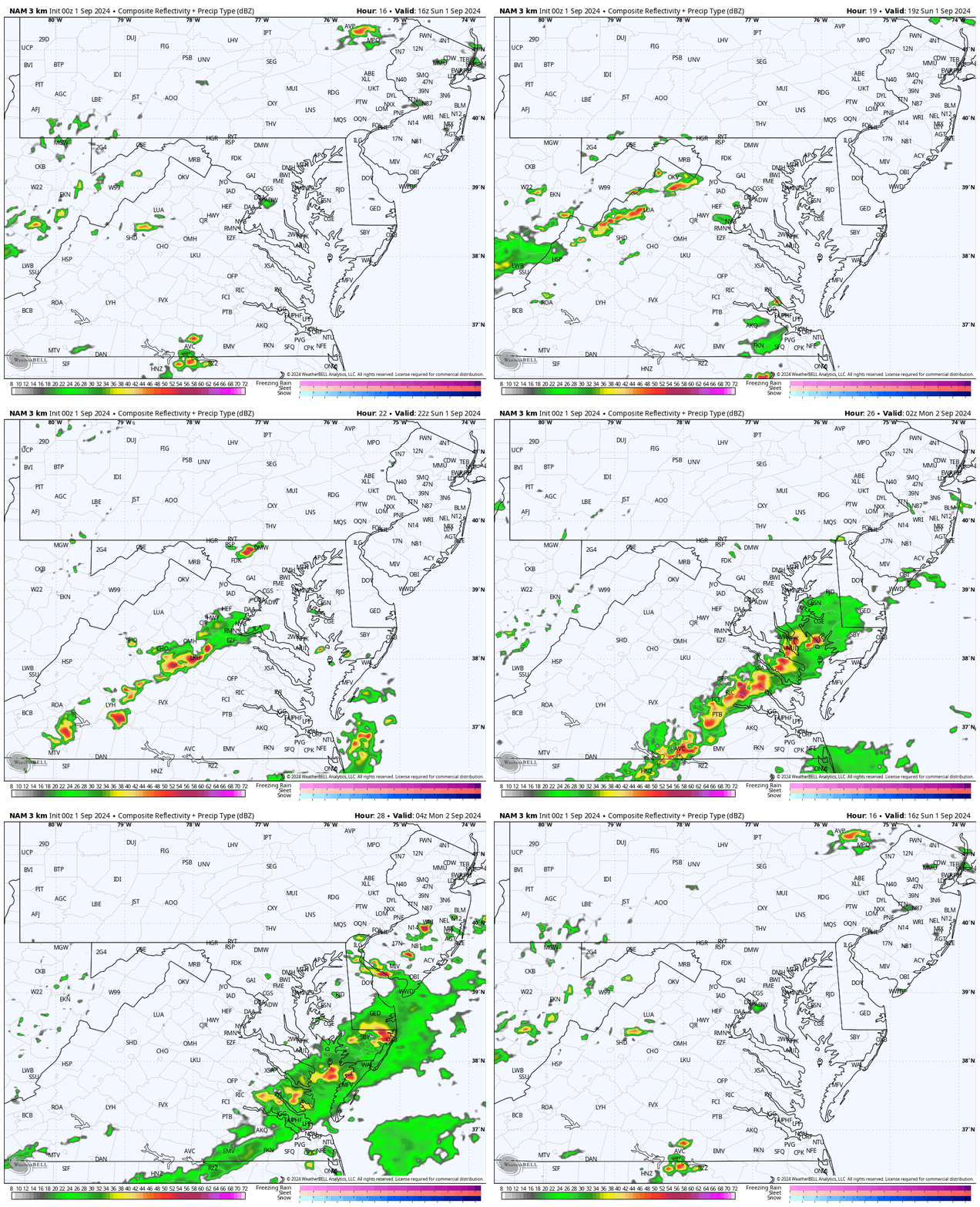
Radar Simulation Noon to Midnight
This is a SUGGESTION, not a promise. I am starting this at midday because of the low confidence in the smaller showers we may see this morning. The afternoon activity may be busier than shown here.
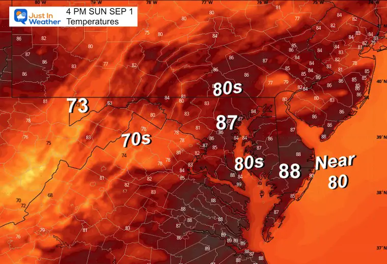
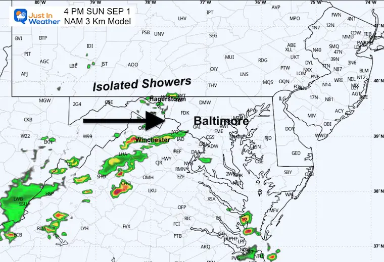
Radar Simulation Snapshot at 4 PM
The best ‘suggestion’ for where the storms will set up this afternoon.
Temperatures
How warm it gets will depend on how much sunshine breaks through. It will definitely be cooler than yesterday.
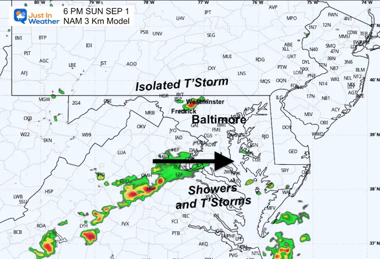
Radar Simulation Snapshot at 6 PM
An isolated thunderstorm may pop up across the inland suburbs west of Baltimore.
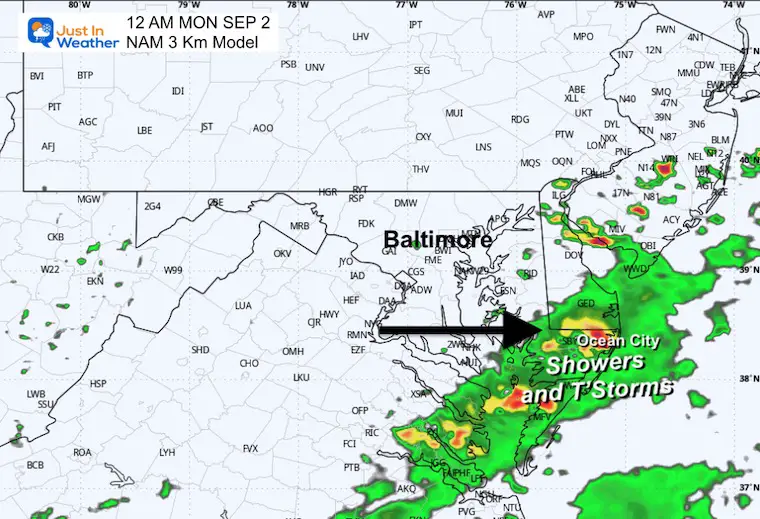
Radar Simulation Snapshot at Midnight
A band of rain with some heavier storms will cross Southern Maryland. This is the cluster that may keep thunder and lightning between Salisbury and Ocean City tonight.
CLIMATE DATA: Baltimore
TODAY September 1
Sunrise at 6:36 AM
Sunset at 7:36 PM
Normal Low in Baltimore: 63ºF
Record 53ºF in 1963
Normal High in Baltimore: 84ºF
Record 99ºF 1962
Summer Hot Day Totals At BWI
8 Days at or above 100ºF
41 Days total at or above 90ºF
MONDAY SEPTEMBER 2
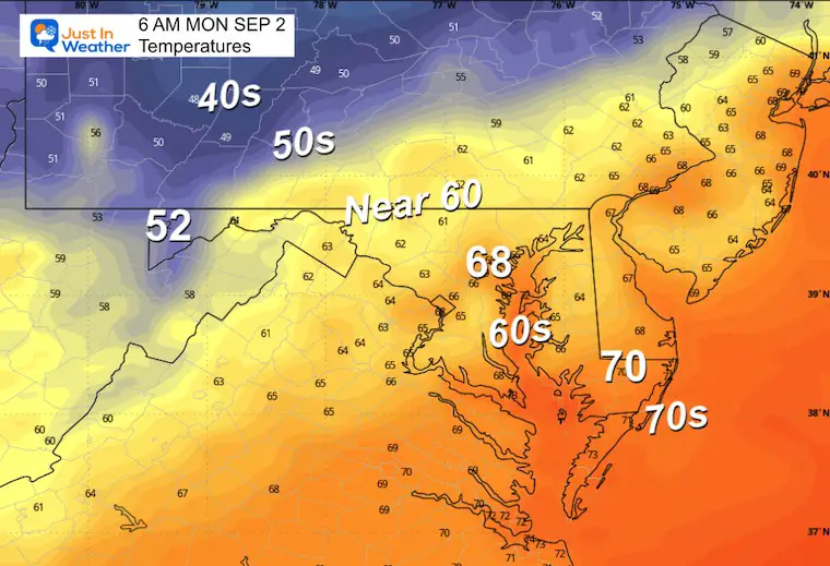
Morning Temperatures
Starting to notice the cooler air. Check out the 50s and 40s in the mountains to our Northwest!
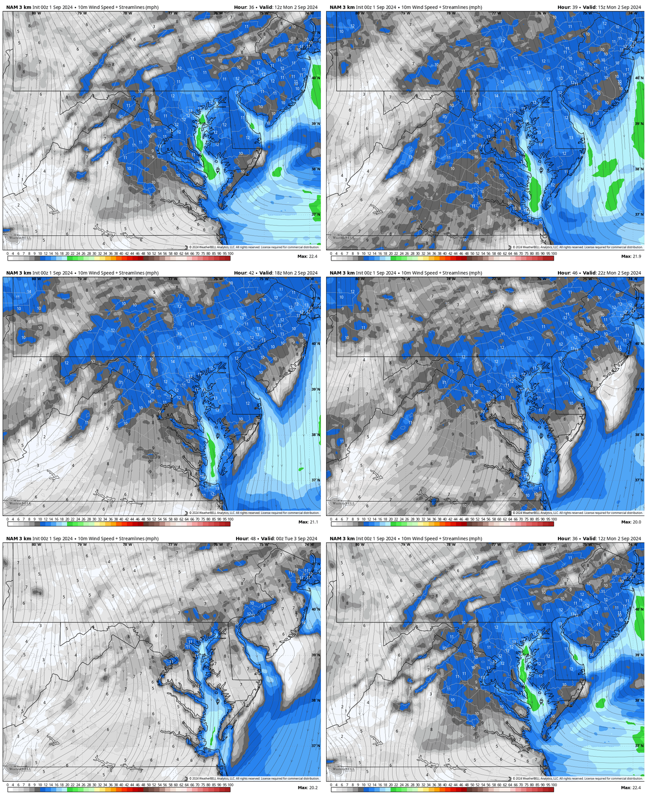
Wind Forecast 8 AM to 8 PM
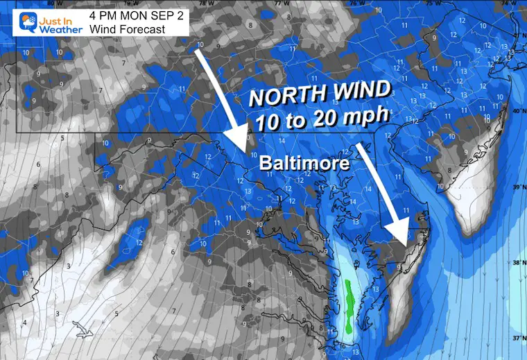
Snapshot at 4 PM
A solid air flow FROM the NORTH will average 10 to 20 mph. This will bring in the cooler air and lower humidity.
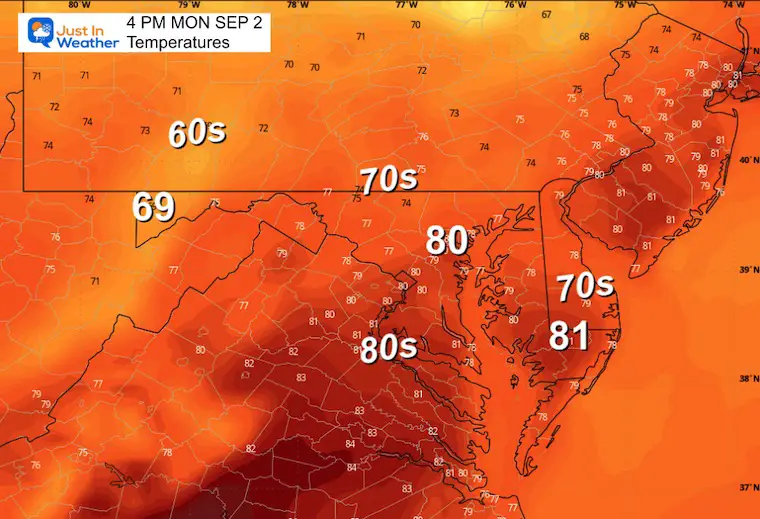
Afternoon Temperatures
Metro areas may reach 80ºF, but the 70s become more common.
Looking Ahead
Tuesday Morning To Saturday Evening
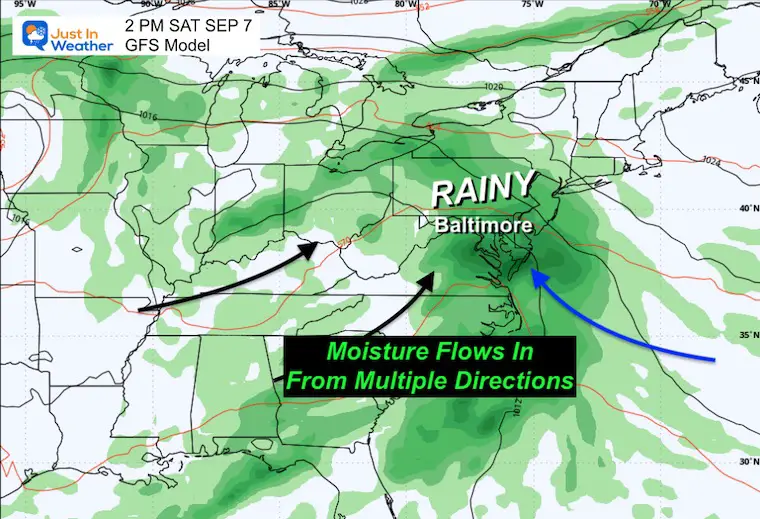
High Pressure will dominate the week with a clear and cool feel. Then, it will pivot off the coast and push damp wind off the ocean, increasing clouds and rain by next weekend.
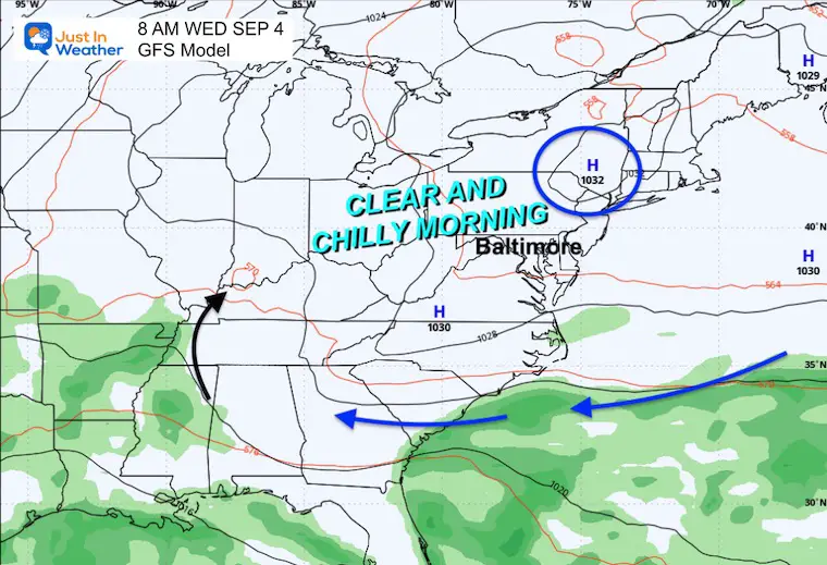
Snapshot Wednesday Morning
This should be the chilliest of the stretch in the week ahead. The core of High Pressure will be passing just to our North.
The airflow circulating will be pushed into the Southeast US and eventually swing back our way.
Snapshot Saturday Afternoon
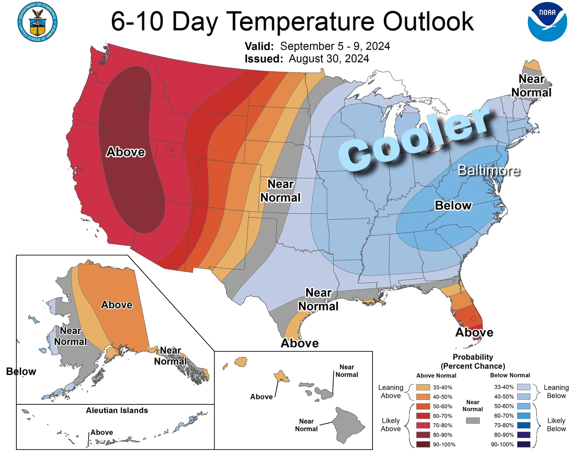
NOAA TEMPERATURE OUTLOOK
The trend for the Eastern half of the nation will be COOLER than average.
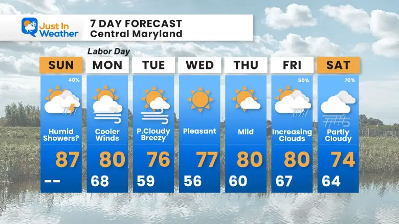
7 Day Forecast
After today, Labor Day looks good! Then we get into the new air mass and seemingly new weather pattern. The 90s are done for at least two weeks, but we can’t rule out one more warm surge.
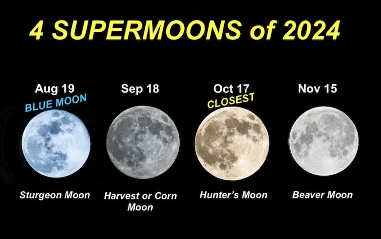
Four Supermoons In A Row
See more about the 4 Supermoons Through November here:
THANK YOU:
Baltimore Magazine Readers Choice Best Of Baltimore
Maryland Trek 11 Day 7 Completed Sat August 10
We raised OVER $104,000 for Just In Power Kids – AND Still Collecting More
The annual event: Hiking and biking 329 miles in 7 days between The Summit of Wisp to Ocean City.
Each day, we honor a kid and their family’s cancer journey.
Fundraising is for Just In Power Kids: Funding Free Holistic Programs. I never have and never will take a penny. It is all for our nonprofit to operate.
Click here or the image to donate:
Please share your thoughts and best weather pics/videos, or just keep in touch via social media.
-
Facebook: Justin Berk, Meteorologist
-
Twitter
-
Instagram
RESTATING MY MESSAGE ABOUT DYSLEXIA
I am aware there are some spelling and grammar typos and occasional other glitches. I take responsibility for my mistakes and even the computer glitches I may miss. I have made a few public statements over the years, but if you are new here, you may have missed it: I have dyslexia and found out during my second year at Cornell University. It didn’t stop me from getting my meteorology degree and being the first to get the AMS CBM in the Baltimore/Washington region.
One of my professors told me that I had made it that far without knowing and to not let it be a crutch going forward. That was Mark Wysocki, and he was absolutely correct! I do miss my mistakes in my own proofreading. The autocorrect spell check on my computer sometimes does an injustice to make it worse. I also can make mistakes in forecasting. No one is perfect at predicting the future. All of the maps and information are accurate. The ‘wordy’ stuff can get sticky.
There has been no editor who can check my work while writing and to have it ready to send out in a newsworthy timeline. Barbara Werner is a member of the web team that helps me maintain this site. She has taken it upon herself to edit typos when she is available. That could be AFTER you read this. I accept this and perhaps proves what you read is really from me… It’s part of my charm. #FITF


