Sunday, August 18 2024
The atmosphere is unstable today and part of the potential for storms will depend on breaks in the clouds for sunshine to add more fuel. The short term forecast below is a suggestion and a comparison of two high resolution models with very different solutions.
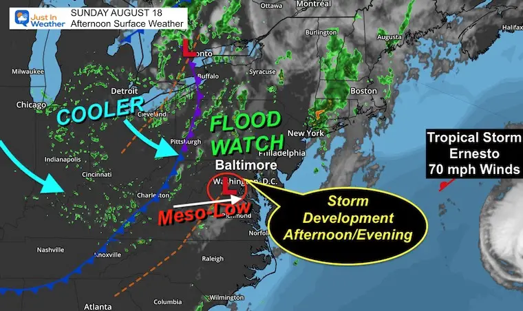
The complication we have is how these moles are seeing a small scale Meso-Low Pressure in Virginia. This is the trigger for the storm development this afternoon and evening. Below I will compare and share which I think is the one to follow, but show both for posterity.
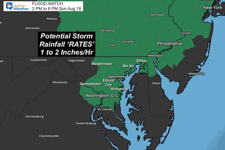
Flood Watch
The potential for heavy rainfall to produce rates of 1 to 2 inches per hour in slow moving storm cells. This includes the western shore of the Chesapeake Bay in Maryland from Annapolis trough metro Washington DC, then up north through central Pennsylvania.
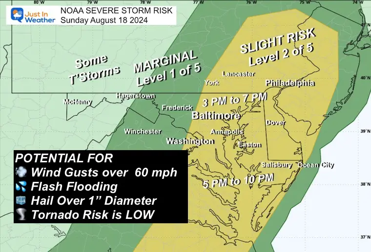
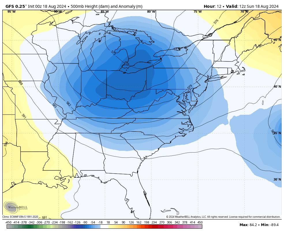
NOAA Severe Storm Risk
Storms may but are not promised to reach severe levels, which can produce:
- Flash Flooding
- Winds Gusts Over 60 mph
- Hail Over 1 inch diameter
- Tornado risk is low but one or two may try to spin up
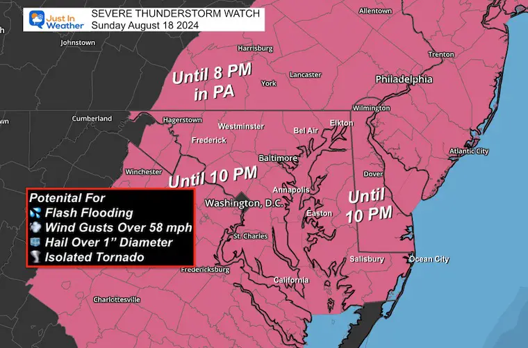
UPDATE 4:30 PM
SEVERE THUNDERSTORM WATCH
Click here or the image below to view the NEW Model Simulations and Live Lightning/Radar
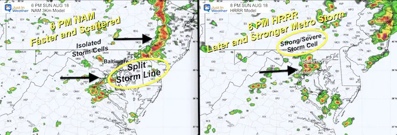
Computer Model Comparison
The NAM Model is FASTER: At 6 PM this shows a storm line crossing the Chesapeake Bay but split with a void of activity near Baltimore.
The HRRR Model is SLOWER: At 8 PM This shows a larger main storm cell reaching Baltimore and affecting central Maryland.
Sunday Set Up
The Meso-Low was located west of Washington DC. This is where some strong to severe storms may develop any time after 3 PM. The other instigator in the atmosphere is a strong cold front, but that is farther west and will not pass through our metro areas until tomorrow.
Behind it will be a Fall Preview of cooler temperatures.
Note: Tropical Storm Ernesto is NOT affecting our weather. Only waves along the beaches.
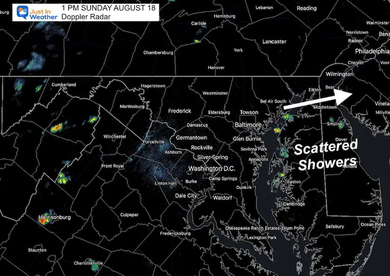
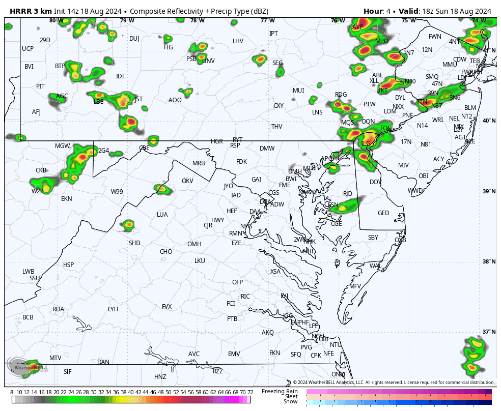
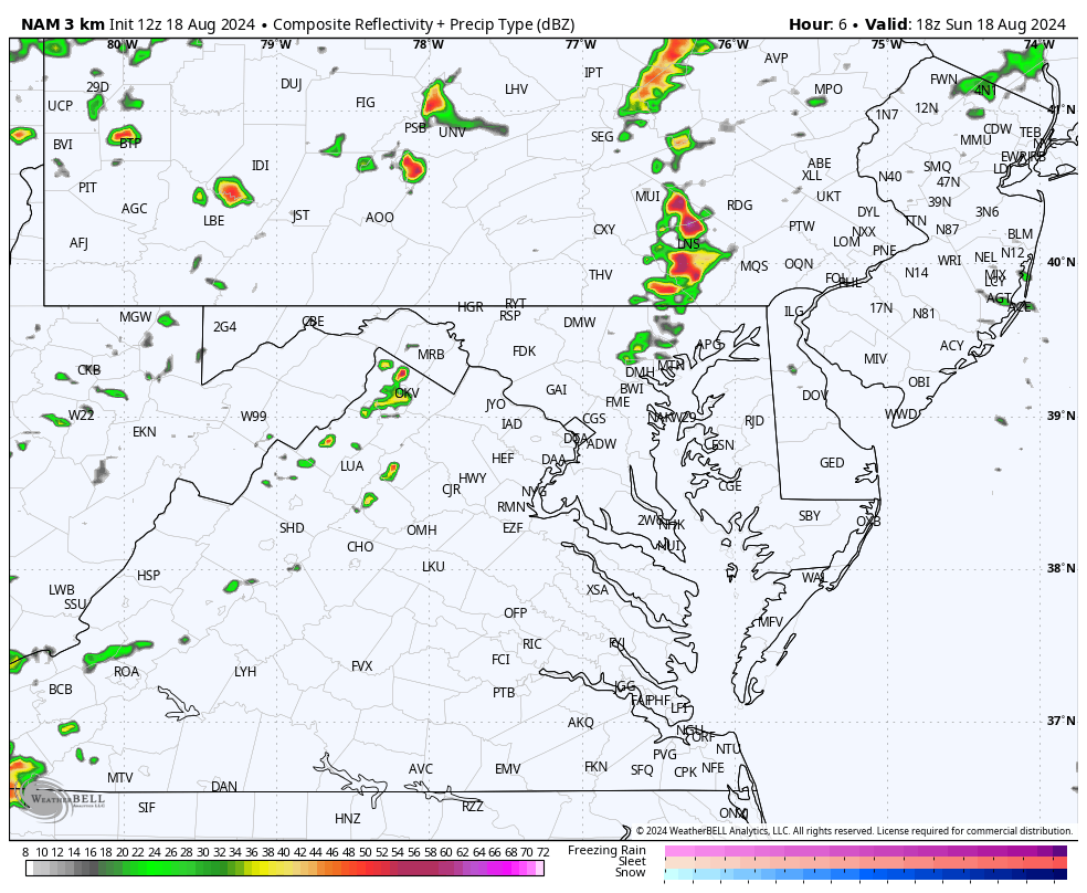
1 PM Doppler Radar Snapshot
Not much action… yet! The value here are the small cells on the Easter Shore. I compared this to the model forecasts for this time slot to see which one was initialized better to handle the shorter term showers.
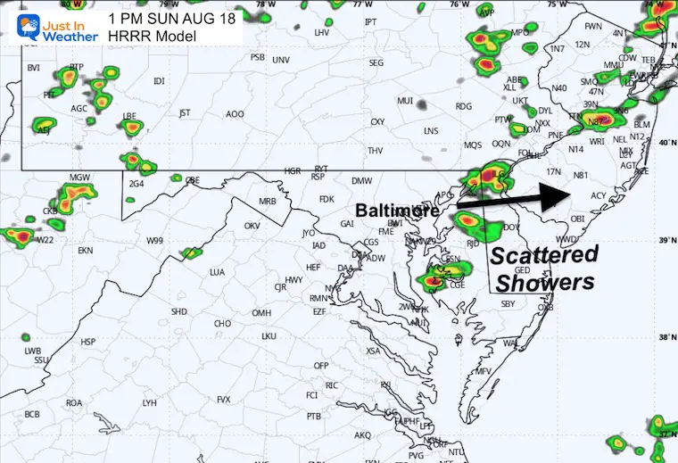
1 PM HRRR Model
This is the better performer, even though a bit stronger than the actual radar. This is the one with a little more credit this afternoon.
Live Radar Widget
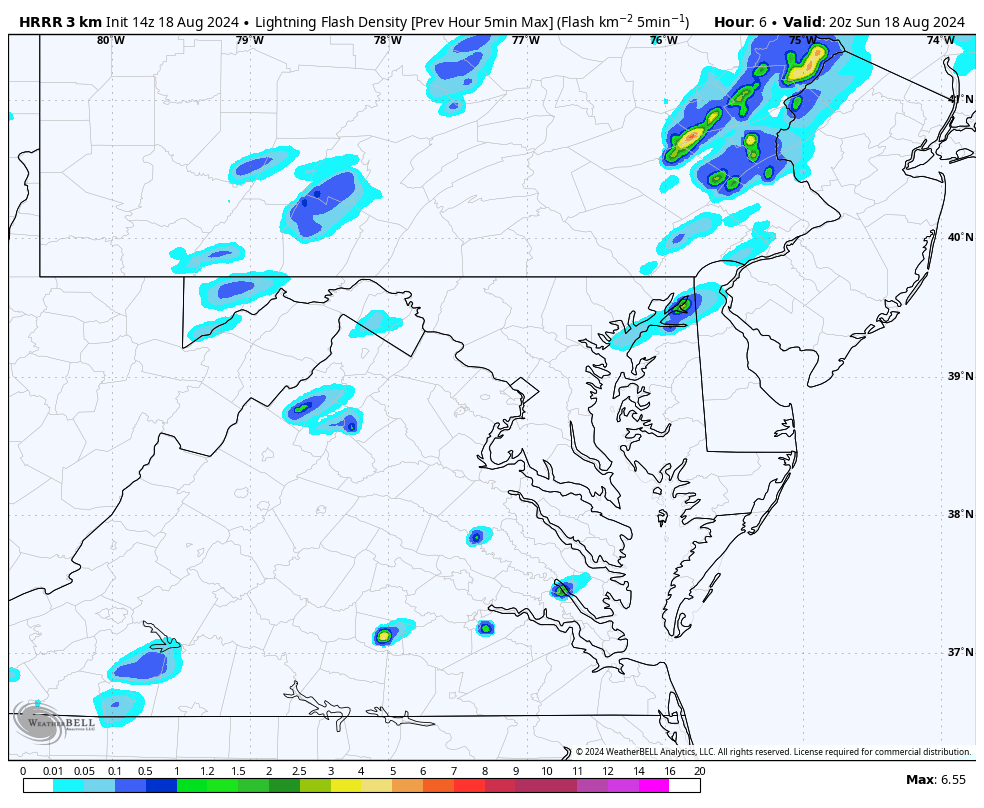
The flare-up of storms will begin between Noon and 2 PM. The peak activity will be 3 PM to 10 PM.
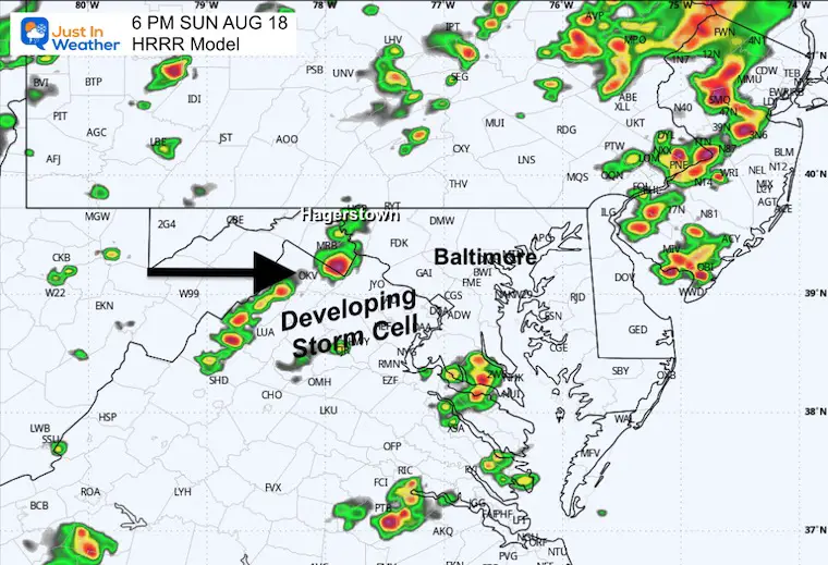
HRRR Model Lightning Forecast 2 PM to Midnight
HRRR Model 2 PM to Midnight
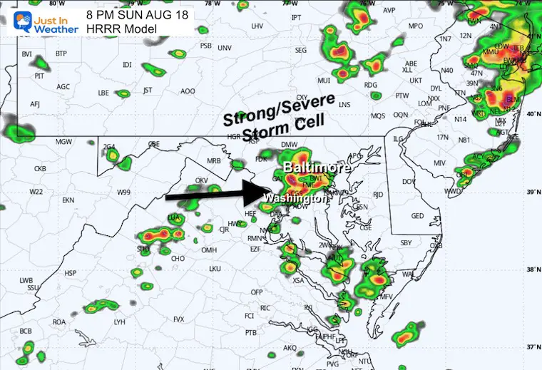
This shows a later arrival of a large strong to severe storm cell affecting Central and Northern Maryland.
The timing in metro Baltimore would be 6 PM to 10 PM… towards the end of the Flood Watch…. So if this verifies that may get extended.
Snapshot
6 PM
Later development of storm cells in the mountains.
8 PM
This model solution has the peak storm cell activity in central Maryland at this time.
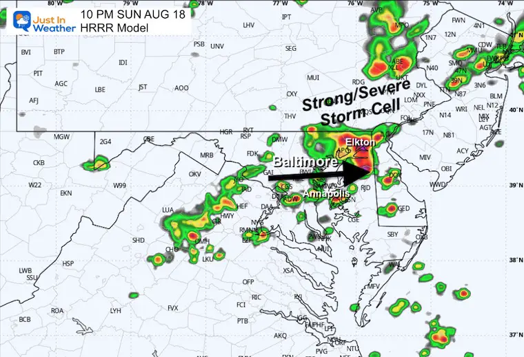
10 PM
This model solution carries that storm cell to Cecil County in Northeastern Maryland and into metro Wilmington/Philadelphia late tonight.
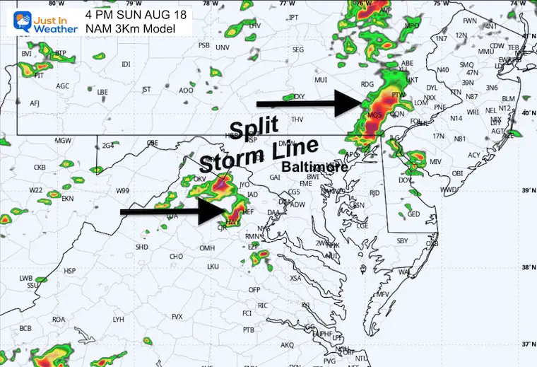
NAM 3 Km Model 2 PM to Midnight
This is a different and FASTER solution. Here we see a large line arriving sooner and affecting a larger area… but not a solid line. So hard to point out this early which will get hit or missed.
This is a possibility even though very different than the HRRR Model above.
4 PM
The NAM has a storm line trying to form from Northeastern MD to the Philadelphia suburbs AND also near Winchester VA.
This is earlier and more active than the HRRR.
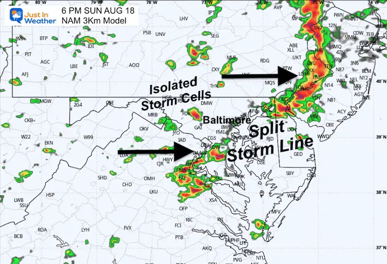
6 PM
Here we see a very active evening, but the suggestion that central Maryland is the void in the middle of that storm line.
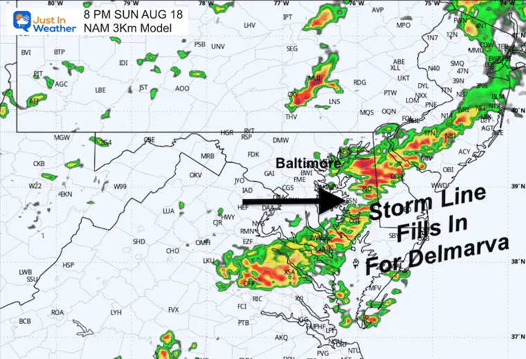
8 PM
LOOKING AHEAD
MONDAY AUGUST 19
The timing of the cold front and new airmass will bring in a drop of temperatures and shift of the rain focus during the afternoon.
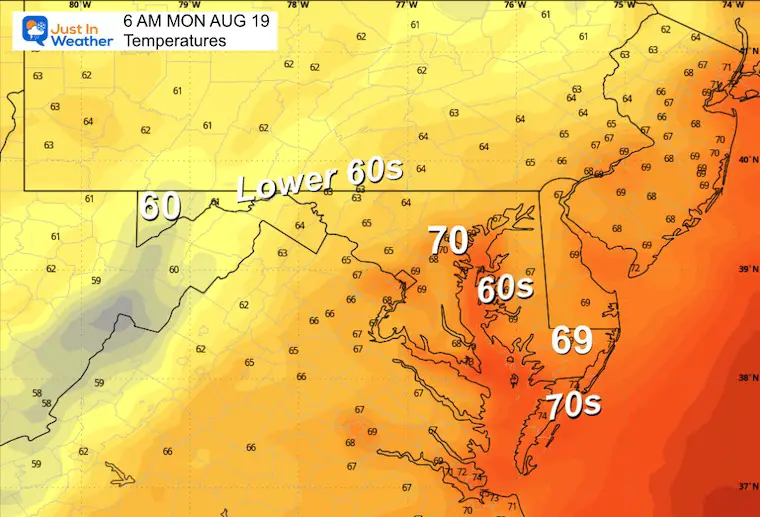
Morning Temperatures
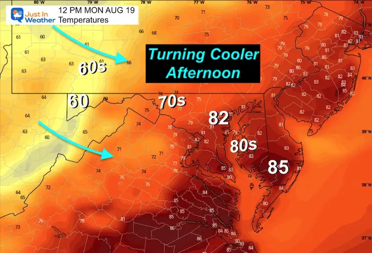
Noon Temperatures
This may be the peak temperatures for the day in central Maryland and nearby as the cold front will be arriving and pushing south in the afternoon.
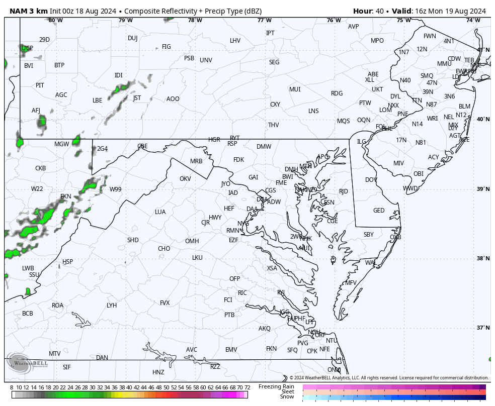
Radar Simulation Noon to Midnight
The cooler air will push the showers and storms to develop during the afternoon and evening.
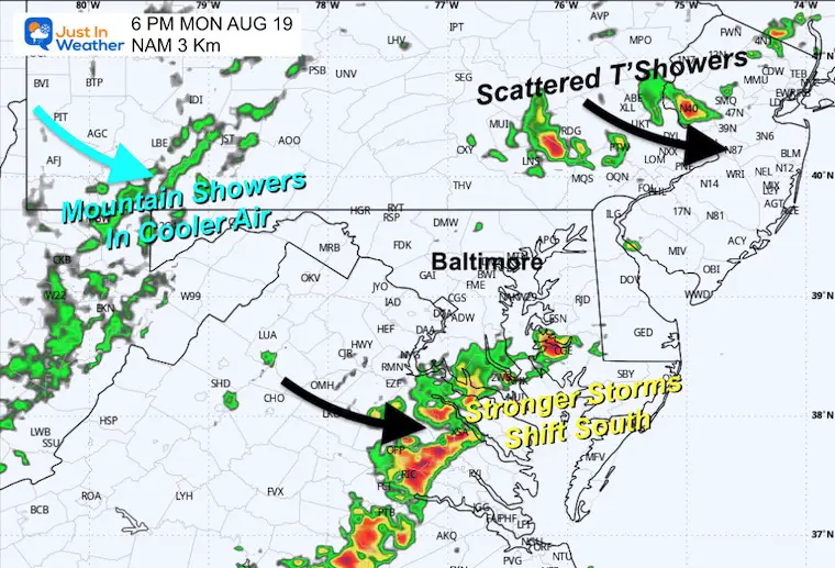
6 PM Radar Suggestion
The cold front will be shifting south, moving the focus for strong or severe storms into Southern Maryland and Southeast VA. There will also be some leftover showers and storms North of Philadelphia into the Poconos.
The mountain showers will be in response to the cooler air arriving.
Jet Stream Sunday to Thursday
The animation shows the 500mb heights. This is around 18,000 ft and represents the warm and cool air in the atmosphere that responds to how high it is measured.
Here, we can see the influx and established Cool Pattern for much of the week.
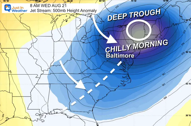
Wednesday Morning Snapshot
The morning will be chilly, with a Deep Upper-Level Trough centered in New England and stretching down the East Coast.
Some inland areas will drop into the 40s.
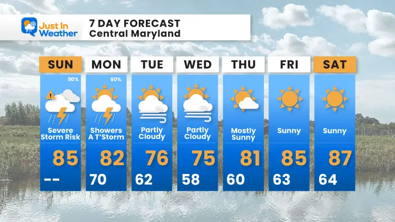
7 Day Forecast
After the storms pass, an Early Fall-Like airmass will settle in for the week. While I am showing 50s for Baltimore metro areas on Wednesday morning, some inland areas will be in the 40s.
THANK YOU:
Baltimore Magazine Readers Choice Best Of Baltimore
Maryland Trek 11 Day 7 Completed Sat August 10
We raised OVER $102,000 for Just In Power Kids – AND Still Collecting More
The annual event: Hiking and biking 329 miles in 7 days between The Summit of Wisp to Ocean City.
Each day, we honor a kid and their family’s cancer journey.
Fundraising is for Just In Power Kids: Funding Free Holistic Programs. I never have and never will take a penny. It is all for our nonprofit to operate.
Click here or the image to donate:

Please share your thoughts and best weather pics/videos, or just keep in touch via social media.
RESTATING MY MESSAGE ABOUT DYSLEXIA
I am aware there are some spelling and grammar typos and occasional other glitches. I take responsibility for my mistakes and even the computer glitches I may miss. I have made a few public statements over the years, but if you are new here, you may have missed it: I have dyslexia and found out during my second year at Cornell University. It didn’t stop me from getting my meteorology degree and being the first to get the AMS CBM in the Baltimore/Washington region.
One of my professors told me that I had made it that far without knowing and to not let it be a crutch going forward. That was Mark Wysocki, and he was absolutely correct! I do miss my mistakes in my own proofreading. The autocorrect spell check on my computer sometimes does an injustice to make it worse. I also can make mistakes in forecasting. No one is perfect at predicting the future. All of the maps and information are accurate. The ‘wordy’ stuff can get sticky.
There has been no editor who can check my work while writing and to have it ready to send out in a newsworthy timeline. Barbara Werner is a member of the web team that helps me maintain this site. She has taken it upon herself to edit typos when she is available. That could be AFTER you read this. I accept this and perhaps proves what you read is really from me… It’s part of my charm. #FITF


