Tuesday, August 6, 2024
Morning Report
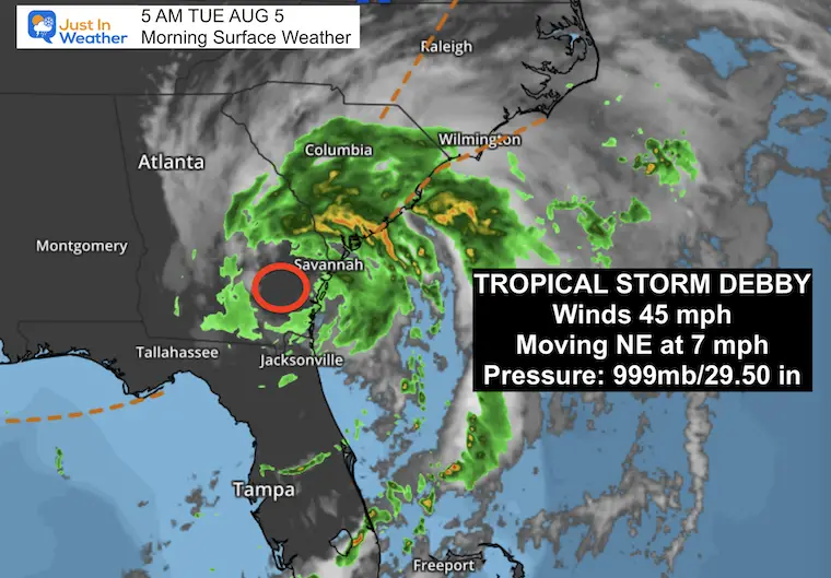
Debby made landfall in Florida yesterday as a Category 1 Hurricane. It remains a Tropical Storm this morning with winds of 45 mph and is about to reemerge over the Atlantic Ocean along the Georgia and South Carolina coastlines. This will allow it to pick up more moisture and dump over 1 foot of rain over a large area.
Morning Surface Weather
Tropical Storm Debby has winds of 45 mph. The forecast return over the water today will allow this to retain or regain strength. It will also pick up more moisture to dump more rain across the Eastern US. This will all be enhanced by an approaching cold front from the Great Lakes that may stall over the Mid-Atlantic for a few days.
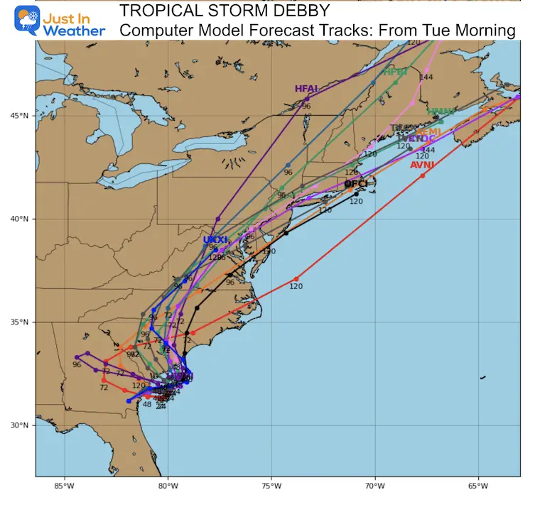
This will be a slow mover, which leaves the track and timing with low confidence. However, a cold front from the west will team up to promise rain. The risk of flooding is also part of the potential.

TRACK TIMING
Here in the Mid-Atlantic, our hot days will be replaced by more clouds and storms over the next few days. The impact of rain will be spread over a few days, but it may still replace the drought with potential flooding. At best, we will split the weekend and get dry weather late Saturday into Sunday.
This has been personally frustrating for two reasons. Tracking and sharing weather information is my job. This week is also my annual Maryland Trek fundraiser, and our team continues to cross the state hiking and biking to honor kids in their cancer journeys. The exact track does not matter because we will definitely get rain. While we must stay on our mission to reach Ocean City on Saturday, safety for all people on our team and crew is a priority!
FLASH FLOOD RISK

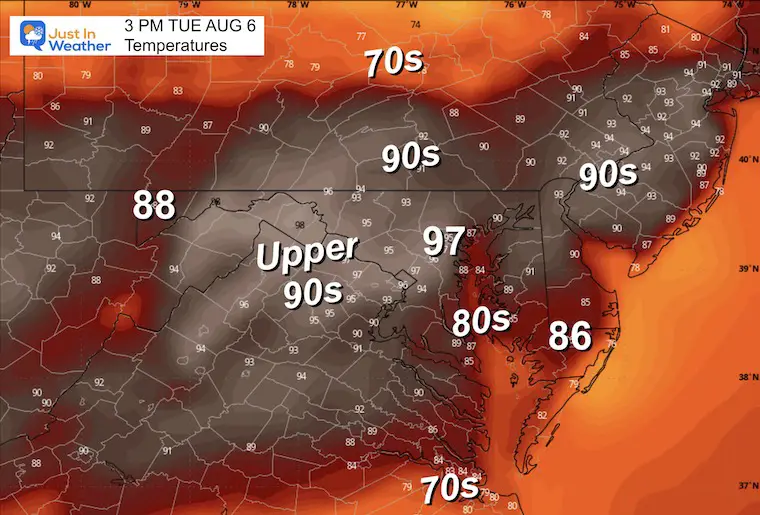
Afternoon Temperatures
Heat Index Values may reach 100ºF again.
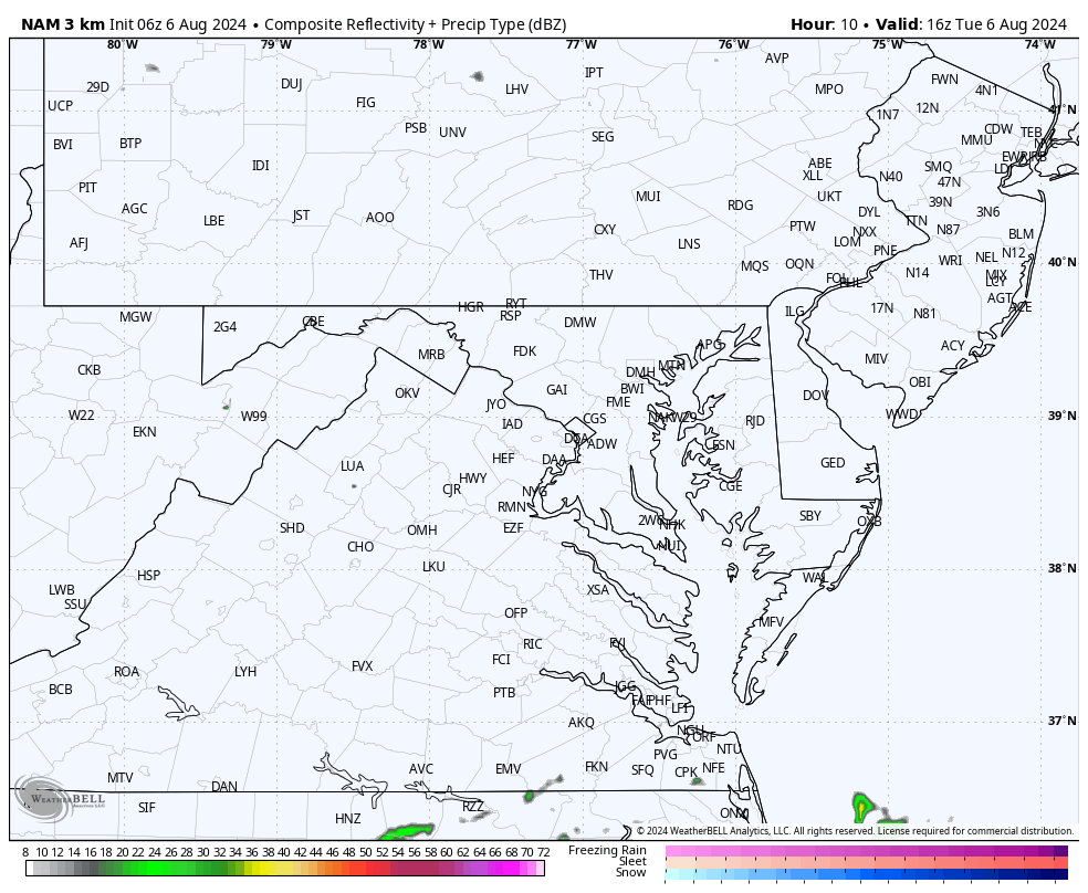
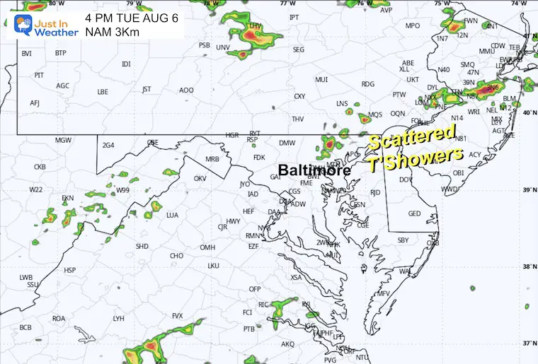
Radar Simulation
Some pockets of thunderstorms may develop between 3 PM and 6 PM.
Radar Simulation Animation Noon to Midnight
Maryland Trek 11 Day 3 From Cumberland to Frederick Tuesday
We begin THIS DAY with a grand total of OVER $67,000 for Just In Power Kids.
The annual event: 329 miles of hiking and biking 329 miles in 7 days between The Summit of Wisp to Ocean City.
Today, we honor Cooper from Hancock to Frederick, about 53 miles.
Each day, we honor a kid and their family’s cancer journey.
Fundraising is for Just In Power Kids: Funding Free Holistic Programs. I never have and never will take a penny. It is all for our nonprofit to operate.
Click here or the image to donate

CLIMATE DATA: Baltimore
TODAY August 6
Sunrise at 6:12 AM
Sunset at 8:12 PM
Normal Low in Baltimore: 67ºF
Record 51ºF in 1951
Normal High in Baltimore: 88ºF
Record 105ºF 1918
Summer Hot Day Totals At BWI
- 8 Days at or above 100ºF
- 37 Days total at or above 90ºF
THANK YOU: Baltimore Magazine Readers Choice Best Of Baltimore
WEDNESDAY AUGUST 7
More rain and thunderstorms are likely in this zone between a cold front in the northwest and Tropical Storm Debby to our South.
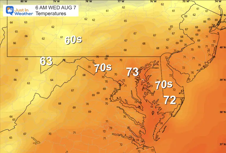
Morning Temperatures
Radar Simulation 8 AM to 6 PM
A band of rain and thunderstorms will pulse across the region.

Snapshot at Noon

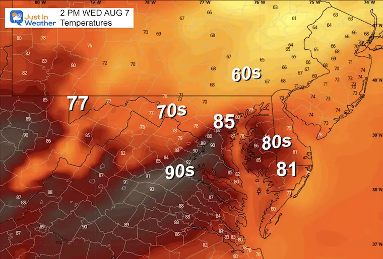
Afternoon Temperatures
Cooler air depends on where the track of rain bands sets up.
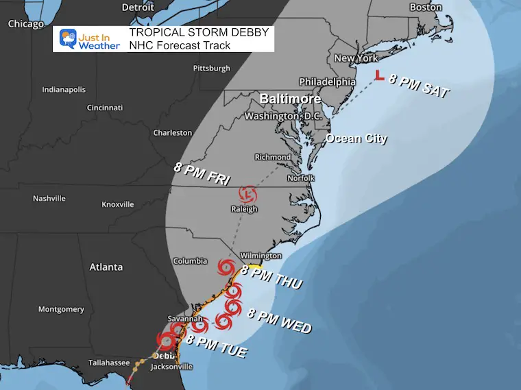
TROPICAL STORM DEBBY
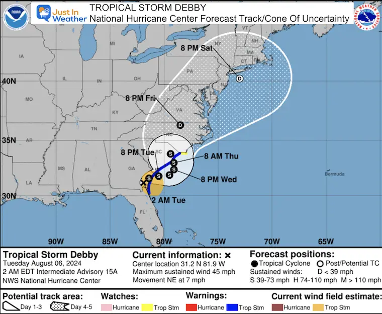
Debby made landfall yesterday near Steinhatchee, in the Big Bend region of Florida as a Category 1 Hurricane. The slow crawl and long range track across the Southeast US and beyond remains in low confidence.
Live Radar Widget
5 AM Stats From The National Hurricane Center
- LOCATION…31.6N 81.6W
- ABOUT 50 MI…80 KM SW OF SAVANNAH GEORGIA
- ABOUT 130 MI…210 KM SW OF CHARLESTON SOUTH CAROLINA
- MAXIMUM SUSTAINED WINDS…45 MPH…75 KM/H
- PRESENT MOVEMENT…NE OR 50 DEGREES AT 7 MPH…11 KM/H
- MINIMUM CENTRAL PRESSURE…999 MB…29.50 INCHES
Warnings and Watches
SUMMARY OF WATCHES AND WARNINGS IN EFFECT:
A Storm Surge Warning is in effect for…
* Altamaha Sound, Georgia to South Santee River, South Carolina
A Storm Surge Watch is in effect for…
* North of South Santee River, South Carolina to Cape Fear, North Carolina
A Tropical Storm Warning is in effect for…
* Ponte Vedra Beach, Florida to Little River Inlet, South Carolina
A Tropical Storm Watch is in effect for…
* North of Little River Inlet, South Carolina to Surf City, North Carolina
NHC Forecast MAP
Outlook Notes
This is a slow-moving storm that will interact with a cold front. The time and area they affect each other leave much open speculation for additional changes. So, regardless of the precise track, moderate to heavy rain is expected Thursday through Saturday.
Tropical Model Forecasts
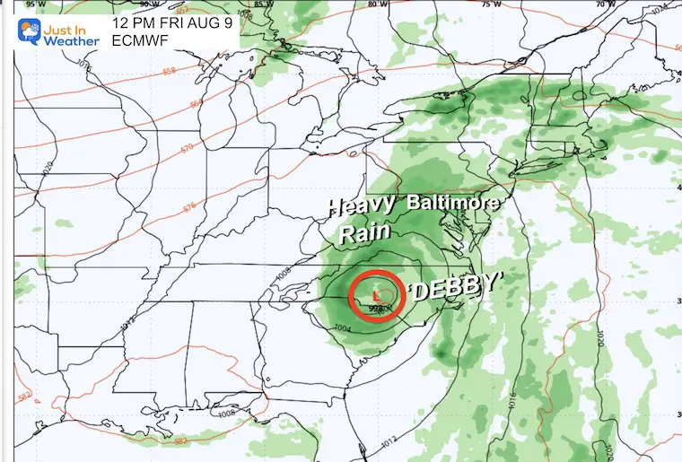
Friday Snapshot: ECMWF Model
The center of Debby is expected to remain to our south at this time. Movement to the North and through our region may hold off until Friday night or Saturday.
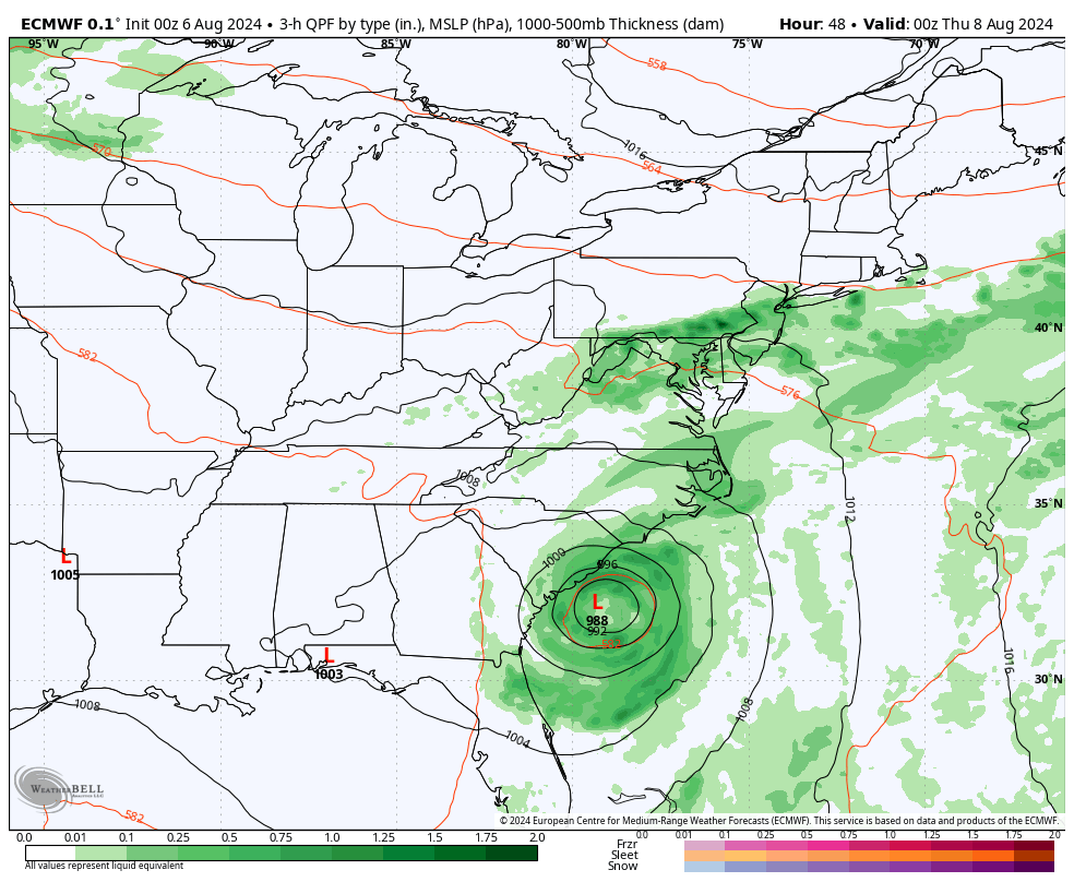
European ECMWF Model Animation
Wednesday to Saturday
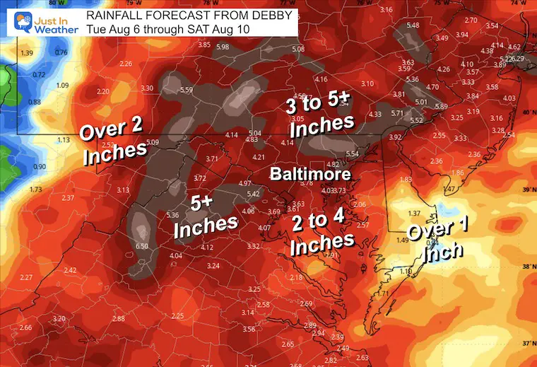
Rainfall Potential
This will be a drought buster. Most of the region can expect between 1 and 3 inches of rain. There may be spots that push 5 inches or more. That will depend on individual bands of rain and how they track or stall.
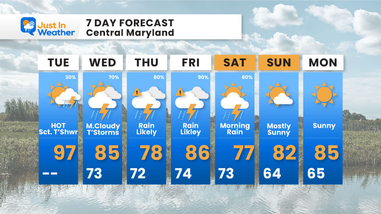
7 Day Forecast
The end of the rain is subject to change depending on the speed and track of Debby.
Please share your thoughts and best weather pics/videos, or just keep in touch via social media.
RESTATING MY MESSAGE ABOUT DYSLEXIA
I am aware there are some spelling and grammar typos and occasional other glitches. I take responsibility for my mistakes and even the computer glitches I may miss. I have made a few public statements over the years, but if you are new here, you may have missed it: I have dyslexia and found out during my second year at Cornell University. It didn’t stop me from getting my meteorology degree and being the first to get the AMS CBM in the Baltimore/Washington region.
One of my professors told me that I had made it that far without knowing and to not let it be a crutch going forward. That was Mark Wysocki, and he was absolutely correct! I do miss my mistakes in my own proofreading. The autocorrect spell check on my computer sometimes does an injustice to make it worse. I also can make mistakes in forecasting. No one is perfect at predicting the future. All of the maps and information are accurate. The ‘wordy’ stuff can get sticky.
There has been no editor who can check my work while writing and to have it ready to send out in a newsworthy timeline. Barbara Werner is a member of the web team that helps me maintain this site. She has taken it upon herself to edit typos when she is available. That could be AFTER you read this. I accept this and perhaps proves what you read is really from me… It’s part of my charm. #FITF


