Monday, August 5 2024
Morning Report
High Confidence in the Heat, Humidity, and possible drought-busting rain later this week. Low Confidence in the precise track of Debby directly or indirectly hitting us in the Mid-Atlantic.
I have a personal concern for the weather this week as my Maryland Trek team continues to cross the state hiking and biking for our annual fundraiser. The increasing heat and humidity will be felt over the next two days. The impact of Hurricane Debby remains high with low confidence. Please let me explain.
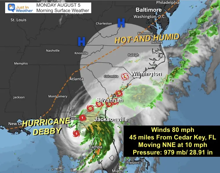
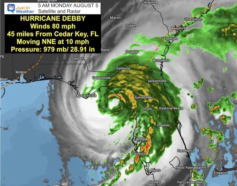
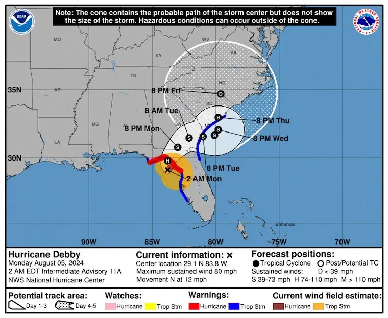
Hurricane Debby has winds of 80 mph. The forecast landfall on Florida and the crawl across the Southeast US are low-confidence later in the week. Computer Models have mostly agreed on a solution to move the remnant Low NORTH to our region. The impact is likely to bring drought-busting rain directly or indirectly. The exact track does not matter because we will get rain either from the storm center or moisture getting pulled our way along a cold front.
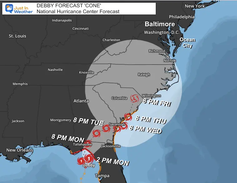
The National Hurricane Center has the storm wandering or looping across the Southeast US. The Mid-Atlantic beaches will experience high water and thunderstorms on many days.
Summer Hot Day Totals At BWI
8 Days at or above 100ºF
36 Days total at or above 90ºF
Morning Surface Weather
Hurricane Debby has winds of 80 mph. The forecast landfall on Florida and the crawl across the Southeast US is low confidence later in the week. The impact is likely to bring drought-busting rain to our region directly or indirectly.
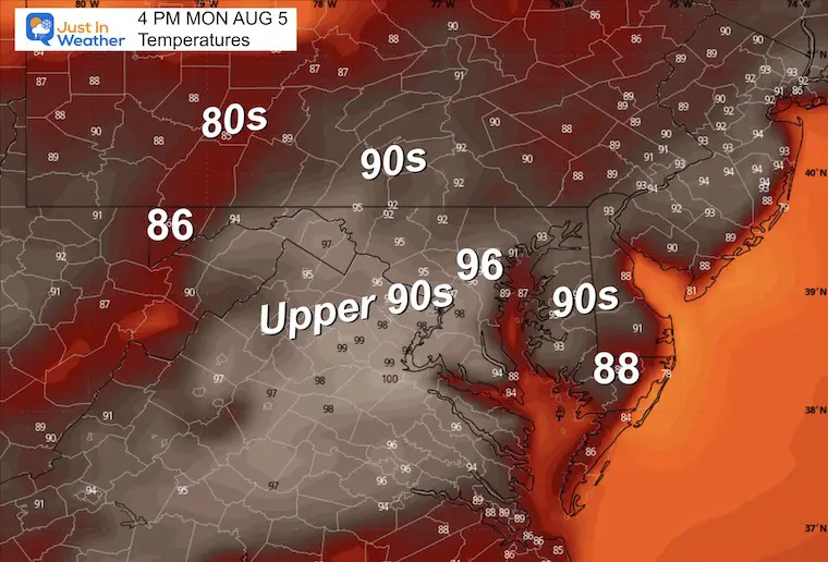
Afternoon Temperatures
Heat Index Values may reach 100ºF.
Maryland Trek 11 Day 2 From Cumberland: Today, Monday
We begin today (Day 2) with a grand total of OVER $65,000 for Just In Power Kids.
The annual event: 329 miles hiking and biking 329 miles in 7 days between The Summit of Wisp to Ocean City.
Today, we honor Paisley from Cumberland to Hancock, about 41 miles.
Each day, we honor a kid and their family’s cancer journey.
Fundraising is for Just In Power Kids: Funding Free Holistic Programs. I never have and never will take a penny. It is all for our nonprofit to operate.
Click here or the image to donate

CLIMATE DATA: Baltimore
TODAY August 5
Sunrise at 6:11 AM
Sunset at 8:13 PM
Normal Low in Baltimore: 67ºF
Record 52ºF in 195
Normal High in Baltimore: 88ºF
Record 104ºF 1930
THANK YOU: Baltimore Magazine Readers Choice Best Of Baltimore
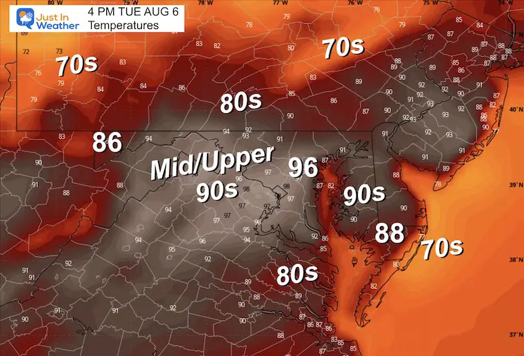
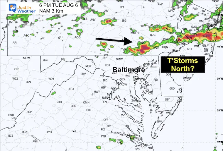
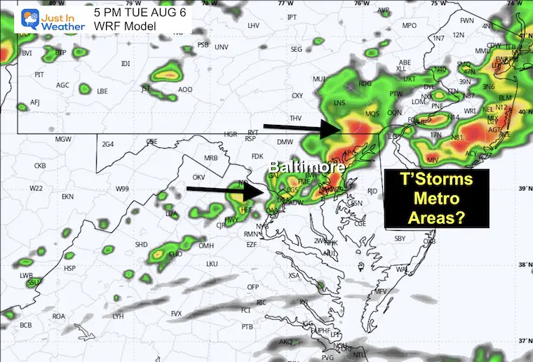
TUESDAY AUGUST 6
High Heat/Humidity and Late Day Storms
The uncertainty with computer guidance already shows up tomorrow. Here we can see a split between late-day storms holding across Southern PA or expanding through Central Maryland. I am leaning toward the wider impact of the WRF Model.
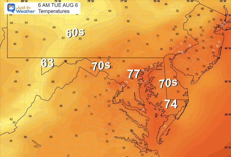
Morning Temperatures
Afternoon Temperatures
Storm Forecast Radar
5 PM NAM Model
5 PM WRF Model (my pick)
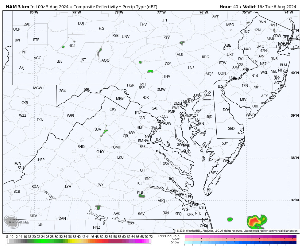
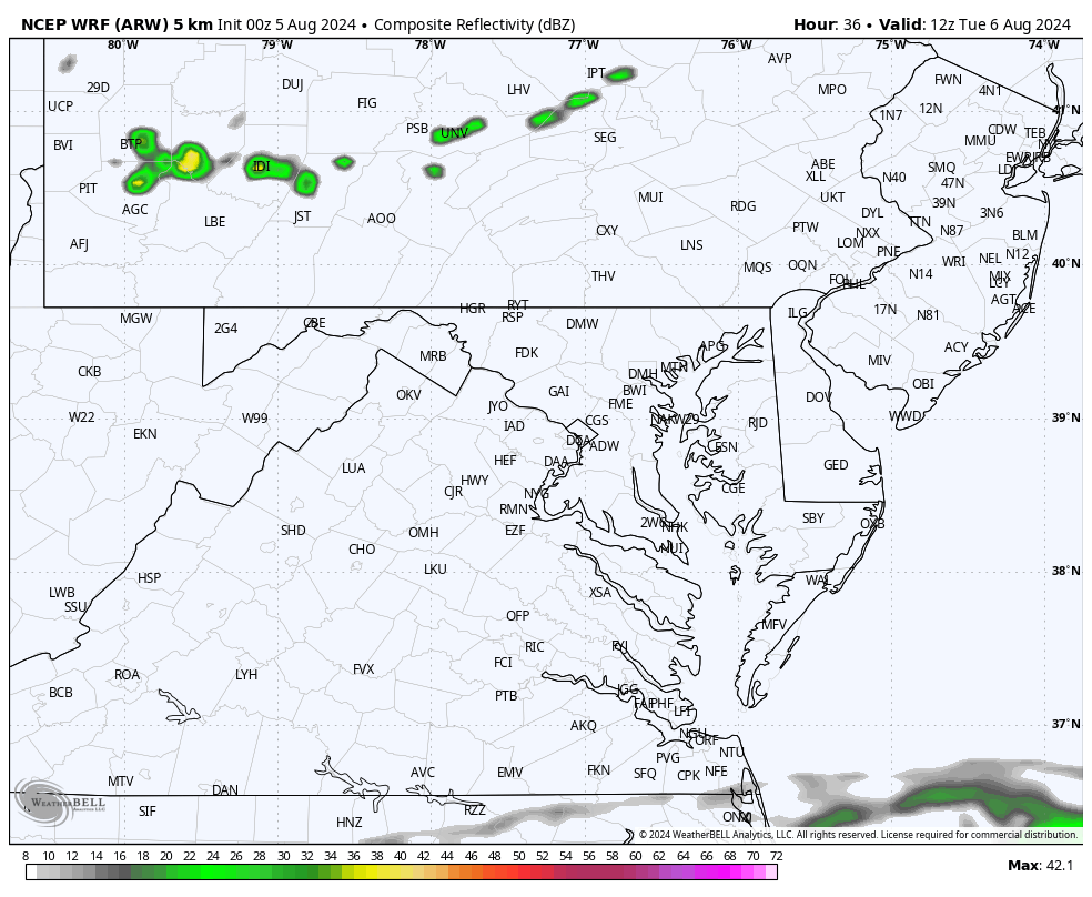
Simulation Animations Noon to Midnight
NAM 3Km
WRF (my pick)
HURRICANE DEBBY
Category 1 Hurricane Debby will make landfall along the Big Bend region of Florida. The slow crawl and long-range track across the Southeast US and beyond remain in low confidence.
Live Radar Widget
5 AM Stats From The National Hurricane Center
- LOCATION…29.5N 83.7W
- ABOUT 45 MI…75 KM NW OF CEDAR KEY FLORIDA
- ABOUT 70 MI…115 KM SSE OF TALLAHASSEE FLORIDA
- MAXIMUM SUSTAINED WINDS…80 MPH…130 KM/H
- PRESENT MOVEMENT…NNE OR 15 DEGREES AT 10 MPH…17 KM/H
- MINIMUM CENTRAL PRESSURE…979 MB…28.91 INCHES
Warnings and Watches
A Storm Surge Warning is in effect for…
* Florida coast from the middle of Longboat Key northward to Indian Pass, including Tampa Bay
* Georgia and South Carolina coast from the Mouth of the St. Mary’s River to South Santee River, South Carolina
A Storm Surge Watch is in effect for…
* Florida coast from Englewood northward to the middle of Longboat Key, including Charlotte Harbor
A Hurricane Warning is in effect for…
* Florida coast from the Yankeetown to Indian Pass
A Tropical Storm Warning is in effect for…
* Florida coast south of Yankeetown to Boca Grande
* Florida coast from west of Indian Pass to Mexico Beach
* St. Augustine to South Santee River South Carolina
Storm Outlook Notes
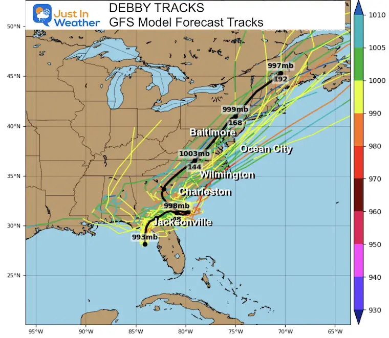
The agreement among computer models is on the near crawl across the Southeast US. There has been a trend to shift this North across the Mid-Atlantic. The timing and track are low-confidence. The storm will weaken, but the rain will spread far and may interact with a frontal boundary to expand the wet region with drought-busting rain.
Tropical Model Forecasts
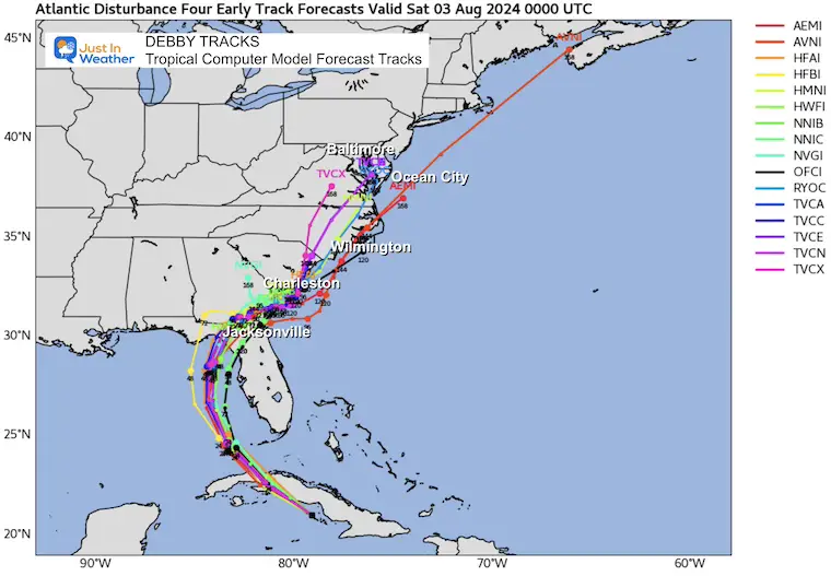
GFS Model Ensemble Forecast Tracks
National Hurricane Center Forecast
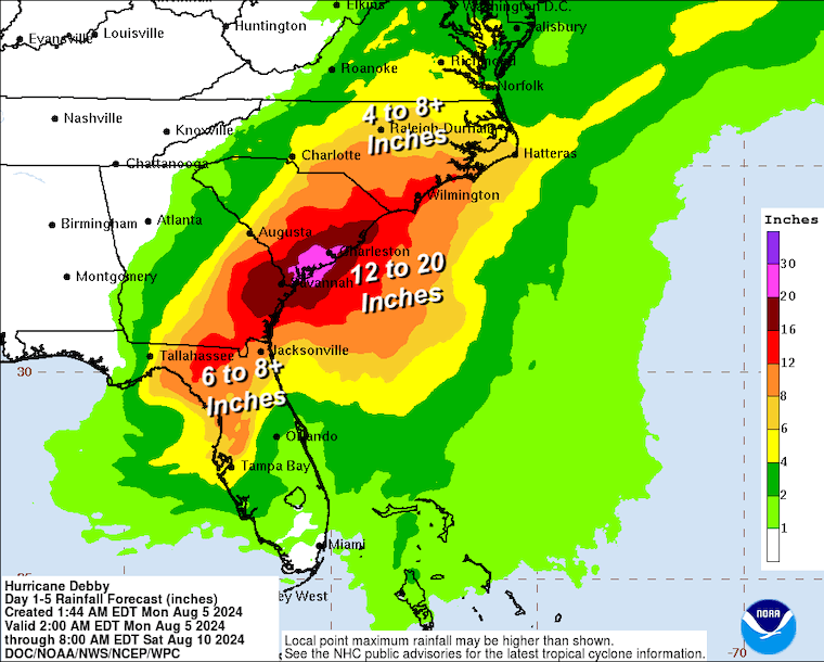
FLOODING RAIN: Forecast From NOAA
Monday Through Saturday.
The expected STALL may produce 12 to 20 inches of rain across coastal South Carolina.
Friday Snapshots
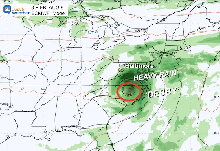
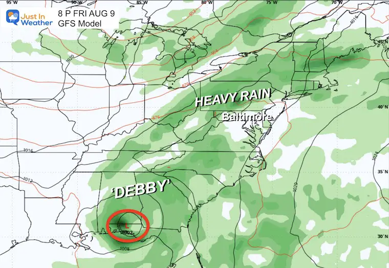
Our Two Main mid-Latitude Models, the GFS and European ECMWF, have very different solutions for Debby’s core but the same result: rain!
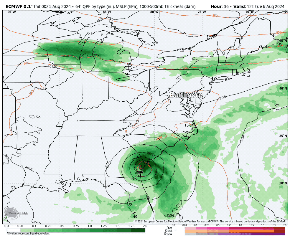
ECMWF Model
This brings the remnant Low into the Mid-Atlantic, resulting in a few days of heavy rain.
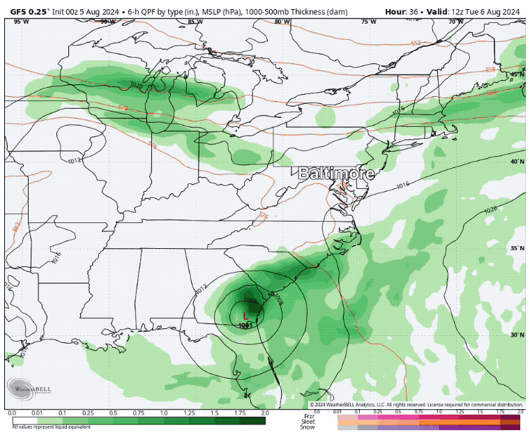
GFS Model
This actually has the Low on the original solution, looping back inland to the West.. But the moisture gets picked up by a frontal boundary also resulting in Heavy Rain.
Forecast Animation Compression Tuesday to Saturday
ECMWF Model
GFS Model
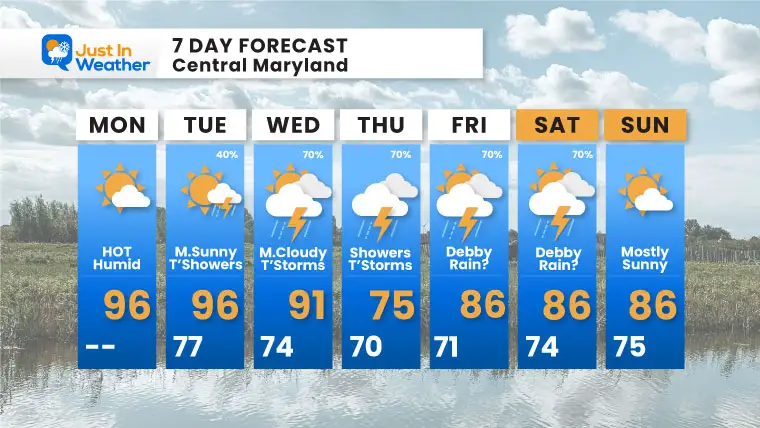
7 Day Forecast
The amount of rain will depend on the track of Debby and interaction with a front inland.
Please share your thoughts and best weather pics/videos, or just keep in touch via social media.
RESTATING MY MESSAGE ABOUT DYSLEXIA
I am aware there are some spelling and grammar typos and occasional other glitches. I take responsibility for my mistakes and even the computer glitches I may miss. I have made a few public statements over the years, but if you are new here, you may have missed it: I have dyslexia and found out during my second year at Cornell University. It didn’t stop me from getting my meteorology degree and being the first to get the AMS CBM in the Baltimore/Washington region.
One of my professors told me that I had made it that far without knowing and to not let it be a crutch going forward. That was Mark Wysocki, and he was absolutely correct! I do miss my mistakes in my own proofreading. The autocorrect spell check on my computer sometimes does an injustice to make it worse. I also can make mistakes in forecasting. No one is perfect at predicting the future. All of the maps and information are accurate. The ‘wordy’ stuff can get sticky.
There has been no editor who can check my work while writing and to have it ready to send out in a newsworthy timeline. Barbara Werner is a member of the web team that helps me maintain this site. She has taken it upon herself to edit typos when she is available. That could be AFTER you read this. I accept this and perhaps proves what you read is really from me… It’s part of my charm. #FITF


