


January 6 Weather Some Fog And Clouds Followed By The Warm Up With Rain By The Weekend
Tuesday, January 6, 2026 The storm track has shifted to the north. We are still on the edge, which is why we have areas of fog, and most of the…
Sunday August 4 2024
Morning Report
This summer continues to push extremes and there is a lot to talk about out. There may be fog this morning after the heavy storms and then a cooler day with more clouds. The tropics have a new named storm that may become a hurricane before landfall on Florida.
This will be a brief report as I am getting ready to kick off the week of Maryland Trek 11 with my team in McHenry. Today we hike and bike 41 miles… So let’s aim for local improvement with our weather.
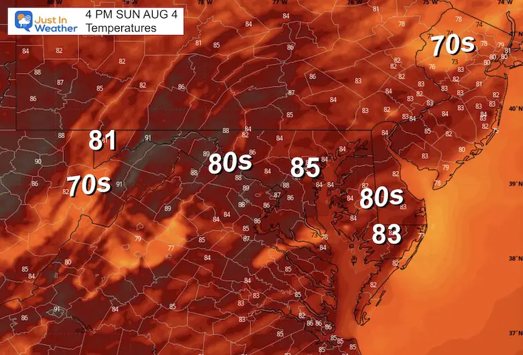
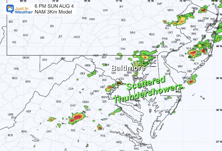
Locally, following yesterday’s big storms, we have clouds, and it will be cooler. There will be some late-day storms again, then back to the high heat tomorrow.
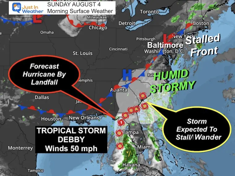
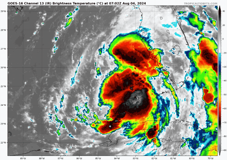
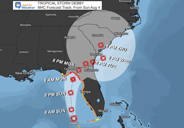
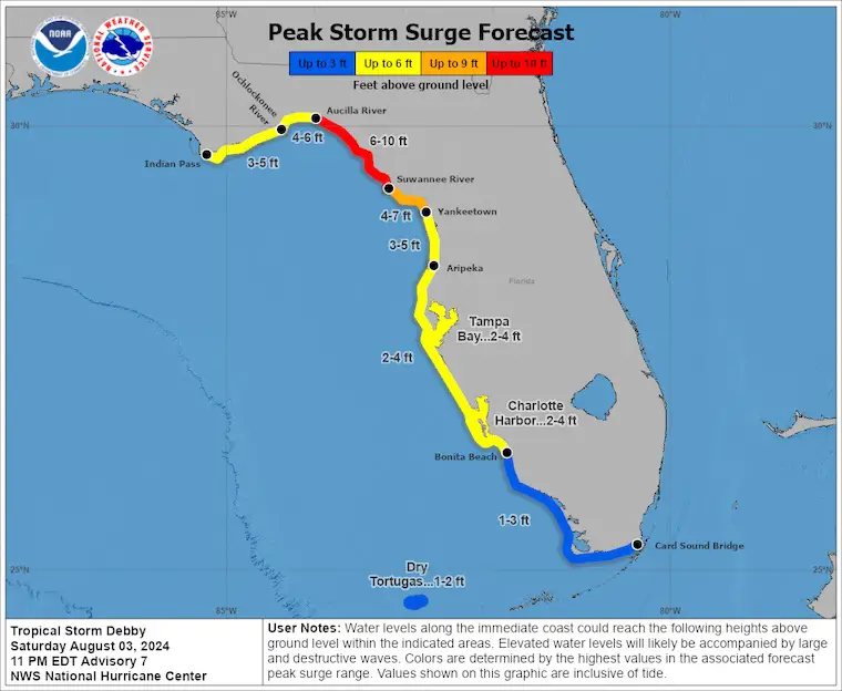
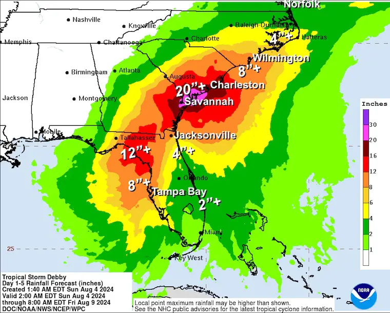
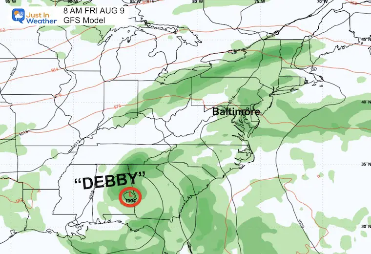
The main event in the week ahead will be Tropical Storm Debby. This storm finally formed last night, and although the core will stay west of the Gulf Coast of Florida, localized flooding is possible. It may hit the Big Bend region as a Category 1 Hurricane and then nearly stall or wander in the Southeast US for most of the week.
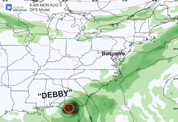
The National Hurricane Center has the storm wandering or looping across the Southeast; some models do bring it north. While it may miss the Mid-Atlantic, it will affect beaches with high water and keep tropical moisture around, with the risk of thunderstorms.
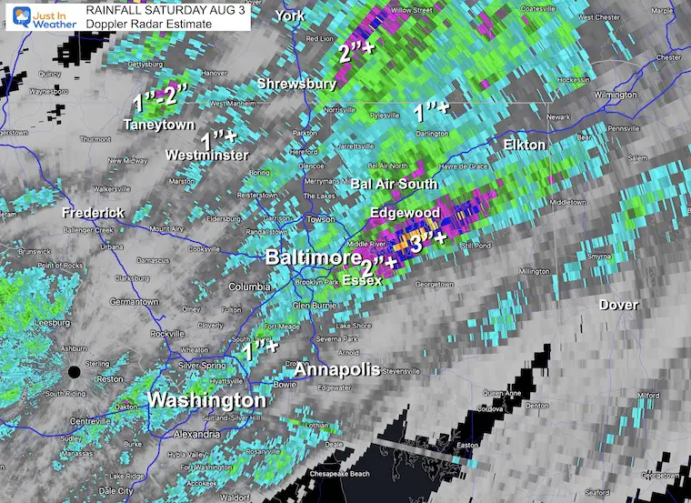
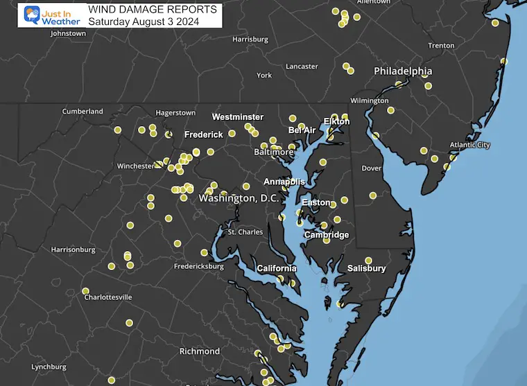
Saturday Storms brought 1 to 3 inches of rain in some spots. There were dozens of wind damage reports across the region as a stalled frontal boundary worked off of the high heat. While not a record, Baltimore hit the 90s for the 36th day this year! Today will be cooler.
A stationary front remains draped over our region and will keep clouds around to hold temps back this afternoon.
Tropical Storm Debby had 50 mph winds off the west coast of Florida.
With the cloud cover, afternoon temperatures should remain in the 80s.
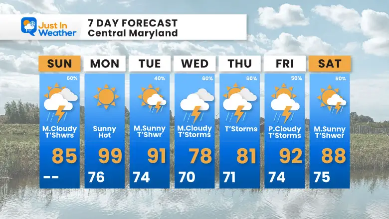
The storm chance is about 60% and will increase late afternoon and evening. This model product has UNDER-REPRESENTED storm coverage.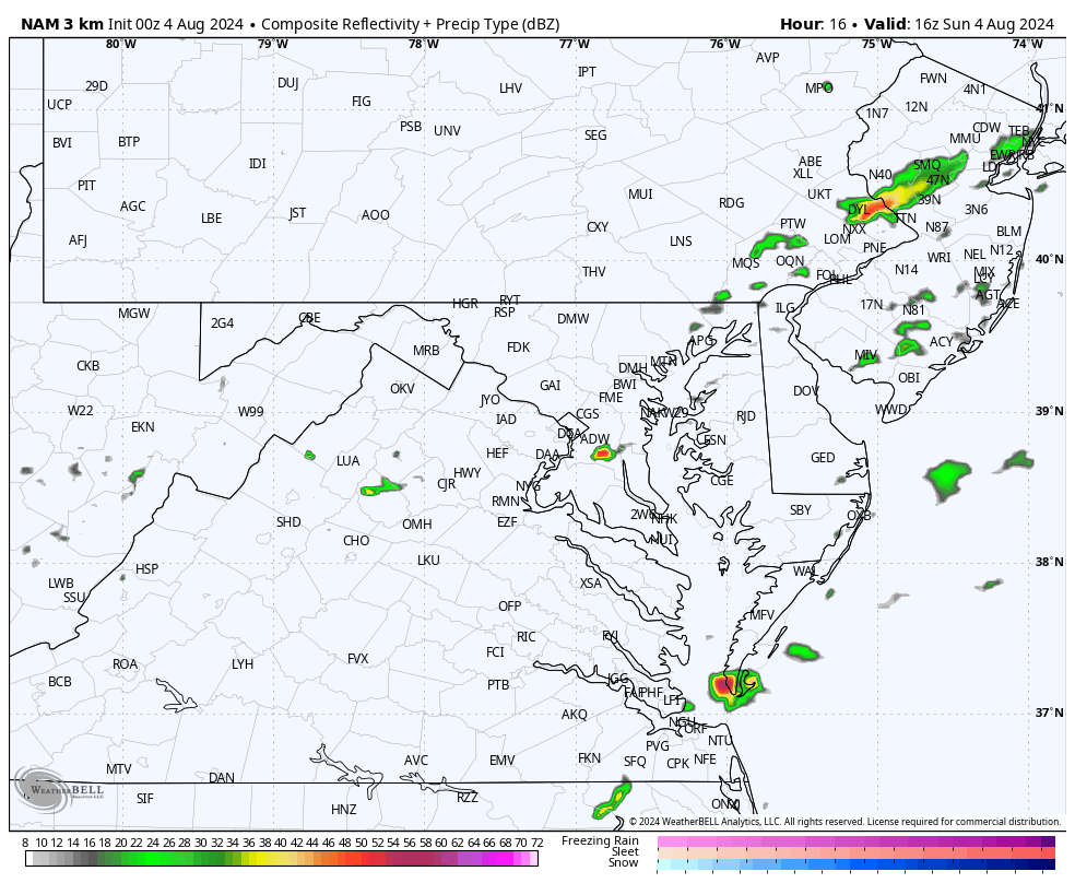
The annual event: 329 miles hiking and biking 329 miles in 7 days from The Summit of Wisp to Ocean City.
Today we honor Gabe crossing Garrett County and ending in Cumberland over 41 miles.
Each day, we honor a kid and their family’s cancer journey.
Fundraising is for Just In Power Kids: Funding Free Holistic Programs. I never have and never will take a penny. It is all for our nonprofit to operate.
Click here or the image to donate

Sunrise at 6:09 AM
Sunset at 8:16 PM
Normal Low in Baltimore: 67ºF
Record 55ºF in 1966
Normal High in Baltimore: 88ºF
Record 101ºF 1930
Sunday July 14: 101ºF in 2024 tied 1895 AND 1954
Monday July 15: 102ºF in 2024 tied 1995
Tuesday July 16: 104ºF in 2024 tied 1988
Not a Record
Wednesday July 17: 100ºF
THANK YOU: Baltimore Magazine Readers Choice Best Of Baltimore
This is forecast to become a Category 1 Hurricane before landfall tomorrow. Some feeder bands with heavy rain have been hitting Florida already.
Most models have this stall off the South Carolina coast. Some do bring it north. While that is unlikely now, it is worth paying close attention to….
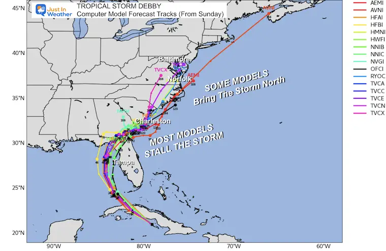
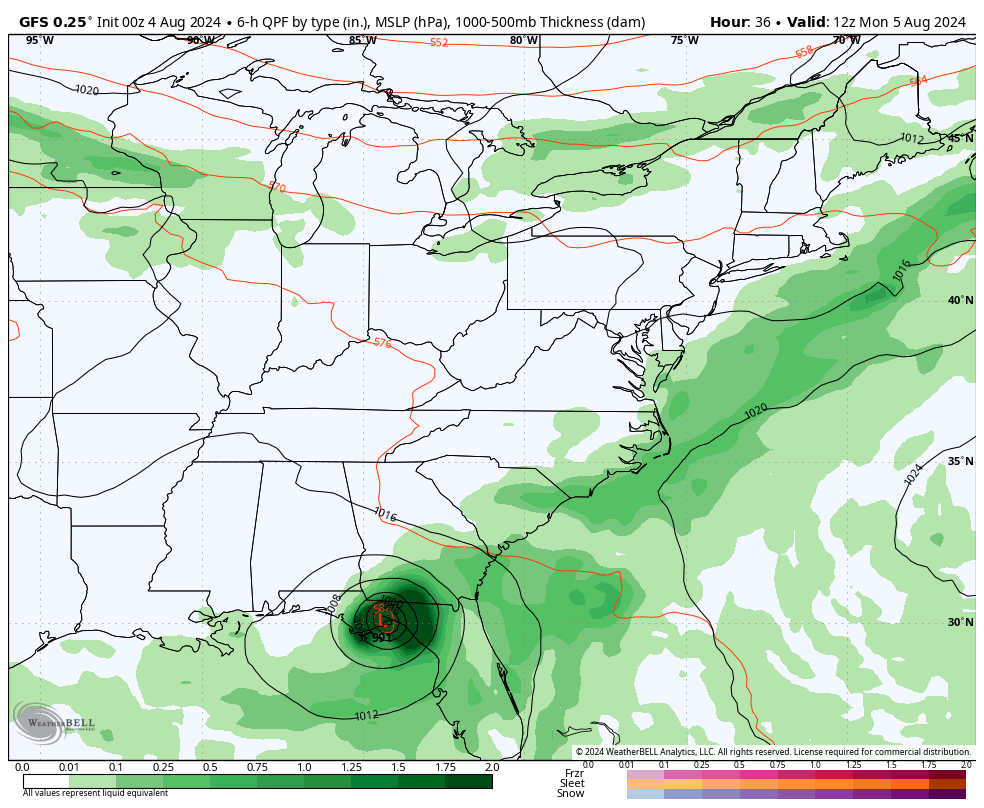
This solution grabs onto the stalling and looping back inland theory.
The GFS Model is among the many having this stall and loop back inland.
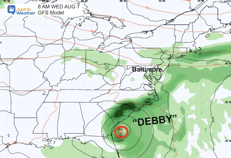
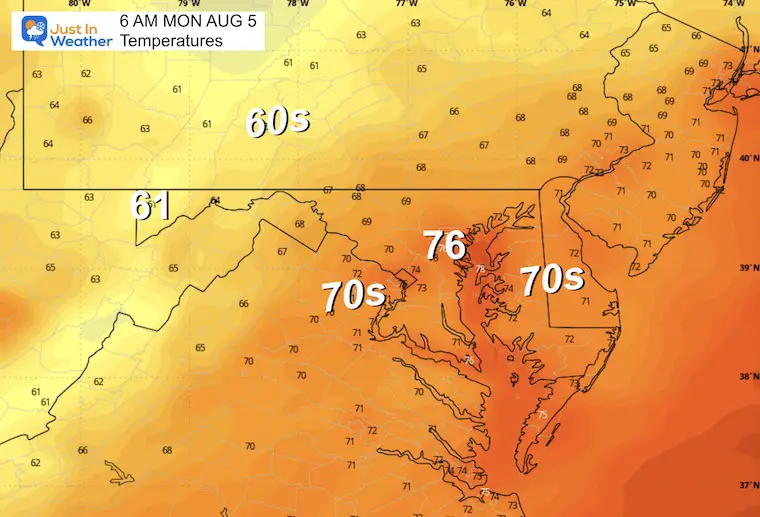
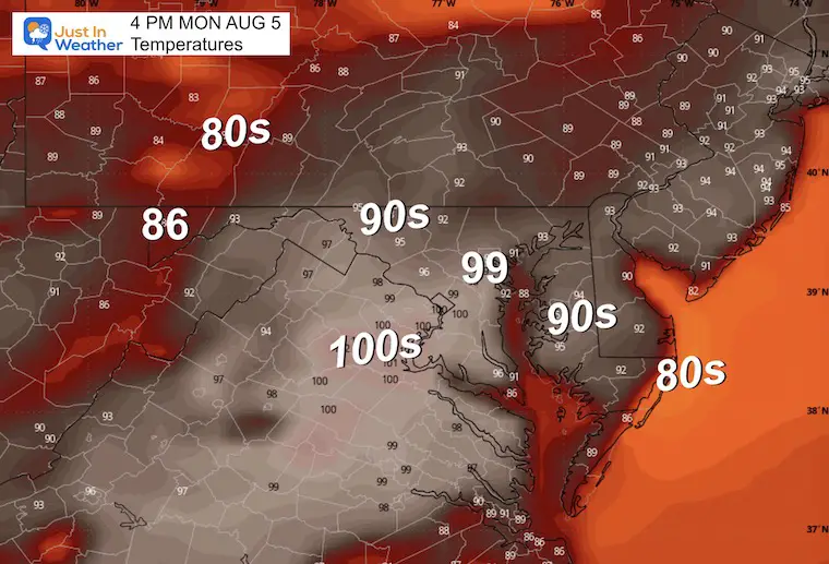
Heat Returns and then we remain uncertain with daily thunderstorms depending on the exact track of Debby.
I am aware there are some spelling and grammar typos and occasional other glitches. I take responsibility for my mistakes and even the computer glitches I may miss. I have made a few public statements over the years, but if you are new here, you may have missed it: I have dyslexia and found out during my second year at Cornell University. It didn’t stop me from getting my meteorology degree and being the first to get the AMS CBM in the Baltimore/Washington region.
One of my professors told me that I had made it that far without knowing and to not let it be a crutch going forward. That was Mark Wysocki, and he was absolutely correct! I do miss my mistakes in my own proofreading. The autocorrect spell check on my computer sometimes does an injustice to make it worse. I also can make mistakes in forecasting. No one is perfect at predicting the future. All of the maps and information are accurate. The ‘wordy’ stuff can get sticky.
There has been no editor who can check my work while writing and to have it ready to send out in a newsworthy timeline. Barbara Werner is a member of the web team that helps me maintain this site. She has taken it upon herself to edit typos when she is available. That could be AFTER you read this. I accept this and perhaps proves what you read is really from me… It’s part of my charm. #FITF