Friday, August 2 2024
It has been a full month since the last named tropical storm was plotted in the Atlantic basin. That was Tropical Storm Chris on July 1 when it made landfall in Mexico. Now, we are on the verge of naming the fourth storm of the season this weekend.
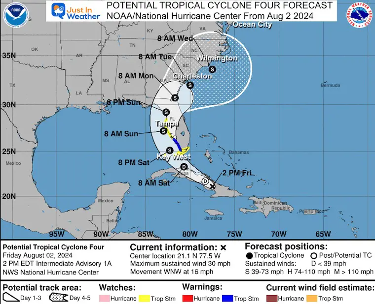
Tropical Cyclone Four had winds of 30 mph and was located about 360 miles from Key West, FL, on Friday afternoon. The National Hurricane Center is expecting this to organize and possibly get named Debby in the next two days. As a result, A Tropical Storm Warning has been issued for Southwest Florida, with a wider area of Watches posted… A landfall on the Gulf Coast of Florida is plotted near Tampa on Sunday morning, then crossing over to the East Coast and slowly moving along the South and North Carolina coast into the middle of next week.
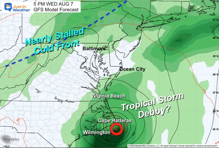
Added concern is the slow movement and lack of guidance aloft, so this can wobble and meander for many days. While this is not expected to directly impact Virginia and Maryland, high water may affect the White Marlin Open, and there is the potential for rip currents along the coast. There may also be an indirect effect of thunderstorms with a cold front that could slow down or stall.
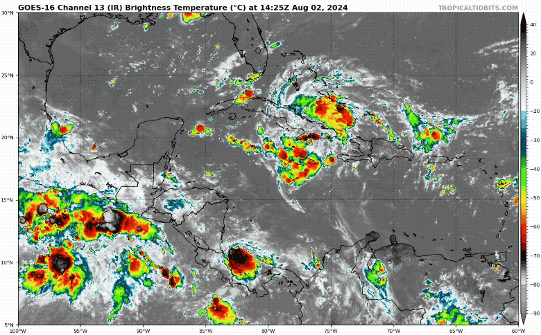
Tropical IR Satellite Loop
While located near Cuba, it is poorly organized.
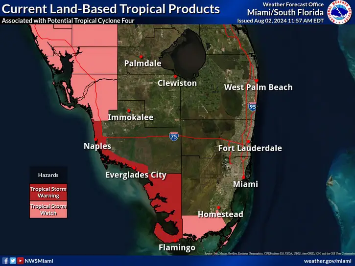
Tropical Storm Watches and Warnings
As Potential Tropical Cyclone Four moves west-northwestward across the Straits of Florida into the Gulf of Mexico, tropical storm development is forecast to occur off Florida’s Gulf coast.
A Tropical Storm Warning is in effect for coastal Collier and mainland Monroe Counties along with the Gulf waters.
A Tropical Storm Watch is in effect for far south Miami-Dade County.
National Hurricane Center Forecast Track
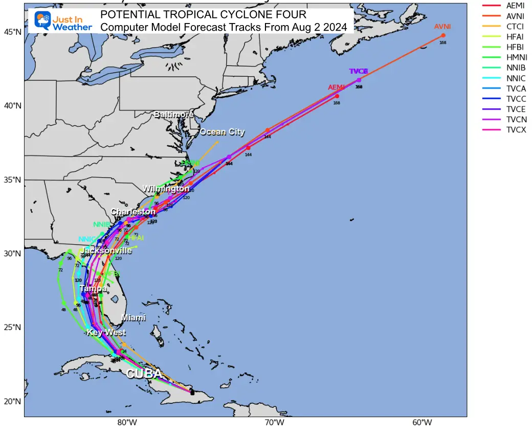
Computer Model Forecast Tracks
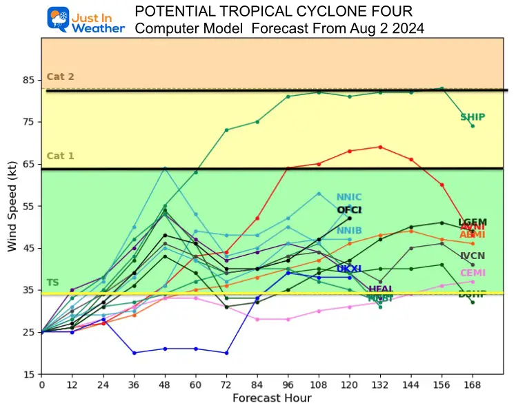
Computer Model Forecast Intensity
At this time, the odds are for a strong tropical storm (winds of 50 mph to 73 mph) with a small chance of reaching Category 1 Hurricane intensity (winds over 74 mph). How close the center remains to the coast may affect the inflow circulation.
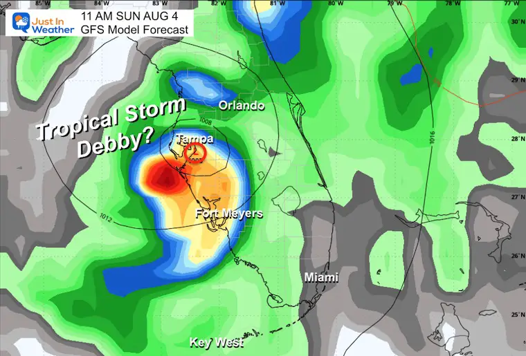
GFS Forecast Sunday Morning
This is a SUGGESTION of a landfall near Tampa, FL.
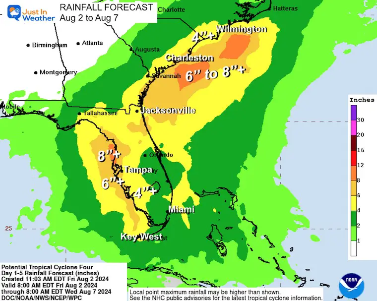
Forecast Rainfall: Florida and Southeast US
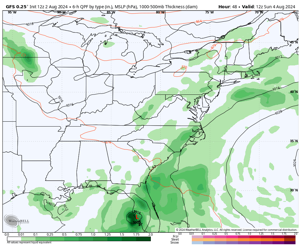
Forecast Model Animation Sunday Morning To Thursday Night
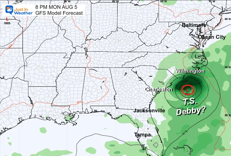
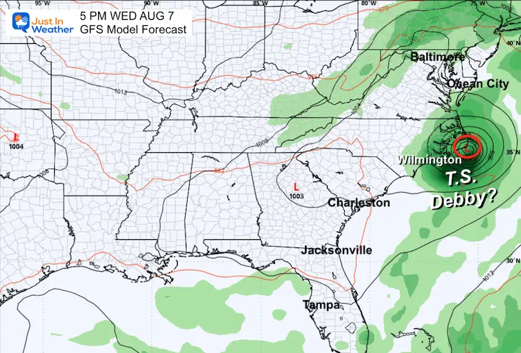
Note the slow movement and nearly stalling off the South and North Carolina coastlines for almost two days. This is subject to change with location and any other atmospheric influence.
Snapshots
Monday
Wednesday
Wednesday Close
Please share your thoughts and best weather pics/videos, or just keep in touch via social media.
RESTATING MY MESSAGE ABOUT DYSLEXIA
I am aware there are some spelling and grammar typos and occasional other glitches. I take responsibility for my mistakes and even the computer glitches I may miss. I have made a few public statements over the years, but if you are new here, you may have missed it: I have dyslexia and found out during my second year at Cornell University. It didn’t stop me from getting my meteorology degree and being the first to get the AMS CBM in the Baltimore/Washington region.
One of my professors told me that I had made it that far without knowing and to not let it be a crutch going forward. That was Mark Wysocki, and he was absolutely correct! I do miss my mistakes in my own proofreading. The autocorrect spell check on my computer sometimes does an injustice to make it worse. I also can make mistakes in forecasting. No one is perfect at predicting the future. All of the maps and information are accurate. The ‘wordy’ stuff can get sticky.
There has been no editor who can check my work while writing and to have it ready to send out in a newsworthy timeline. Barbara Werner is a member of the web team that helps me maintain this site. She has taken it upon herself to edit typos when she is available. That could be AFTER you read this. I accept this and perhaps proves what you read is really from me… It’s part of my charm. #FITF


