Friday, July 5 2024
Morning Report
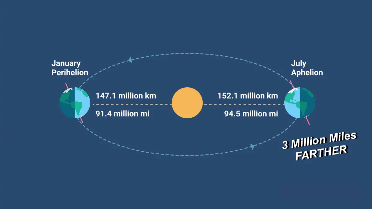
Today is Aphelion Day! The irony of the hottest time of the year in The Northern Hemisphere is also when our planet is farthest from The Sun! Our elliptical orbit around The Sun places Earth at the farthest distance in early July. This morning at 1:06 AM, our planet reached that point, about 94 million miles away. This distance is roughly 3 million miles FARTHER than perihelion (closest) in early January! Note that Earth averages 93 million miles from the sun.
This does result in about 7% less radiant heat, but the angle of Earth’s tilt is why we have our longest daylight hours and higher temperatures.
Today’s Weather
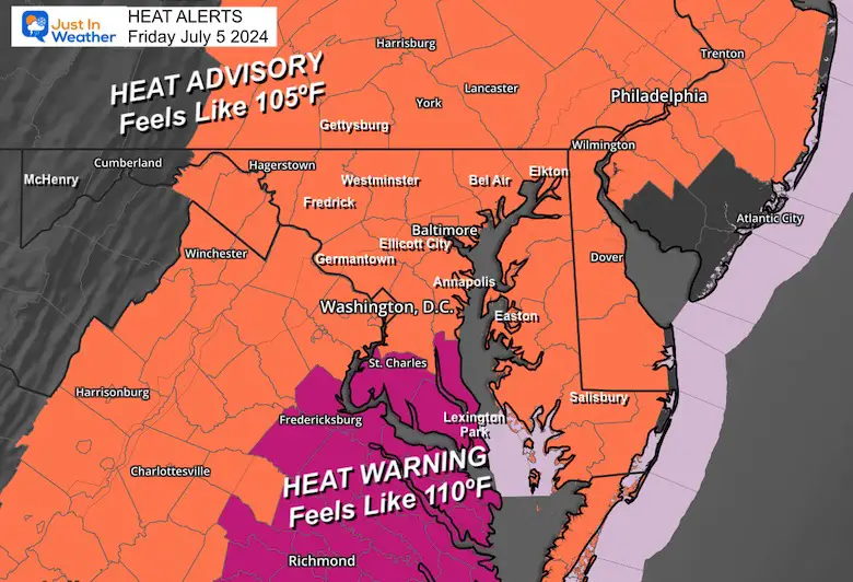
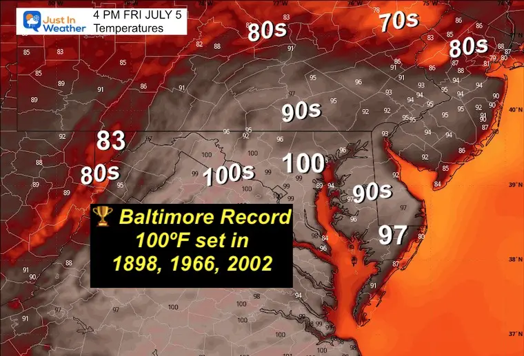
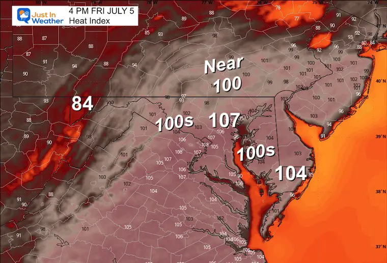
We enter the peak of heat and humidity this afternoon. Temperatures may approach the record high of 100ºF in Baltimore. This may challenge other regional records as well… But it will surely FEEL HOTTER. The heat index may approach 105ºF to 110ºF, which has prompted a Heat Advisory.
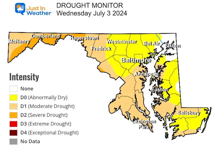
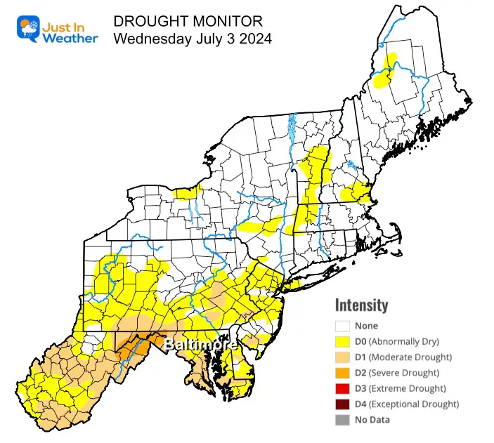
I also want to highlight our growing drought conditions. While the yearly totals are close to average, we have been 3 inches below expectations since June 1. This, plus the high heat, has helped dry out the soil and water levels. We do expect more storms tomorrow.
Heat Advisory and Heat Warnings Today
Drought Monitor
Maryland
Northeast US
More on our local forecast below, but first, a tropical update.
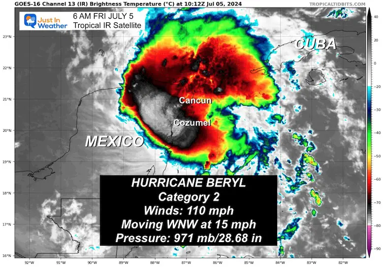
HURRICANE BERYL
The storm has dropped to a Category 2 with 110 mph winds, but remains a very destructive system. It is making landfall this morning along the Yucatan Coast of Mexico south of Cozumel.
- Storm Surge: 4 to 6 Feet
- Rainfall Expected: 4 to 10 inches
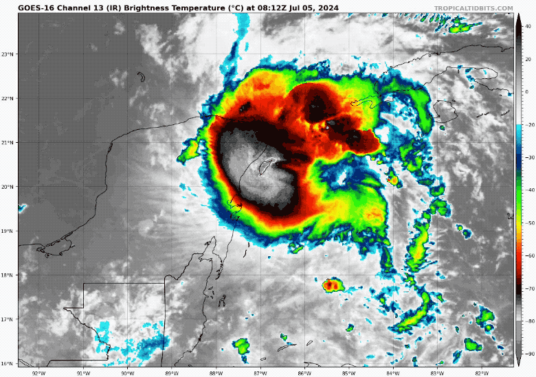
Morning IR Satellite
The footprint has gotten smaller…
- Hurricane Force Winds reach 30 miles from the center.
- Tropical Storm Force Winds reach 105 miles from the center.
LIVE WIND WIDGET
SUMMARY OF 400 AM CDT…0900 UTC…INFORMATION
———————————————-
LOCATION…20.1N 86.9W
ABOUT 40 MI…65 KM E OF TULUM MEXICO
ABOUT 780 MI…1250 KM ESE OF BROWNSVILLE TEXAS
MAXIMUM SUSTAINED WINDS…110 MPH…175 KM/H
PRESENT MOVEMENT...WNW OR 285 DEGREES AT 15 MPH…24 KM/H
MINIMUM CENTRAL PRESSURE…971 MB…28.68 INCHES
Morning Satellite Loop
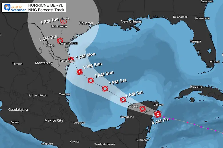
Tropical Forecast
Beryl will weaken to a Tropical Storm and may possibly regain Hurricane intensity over the weekend when reemerging over water. The final landfall may be close to the Southern Border of Texas on Monday.
National Hurricane Center Forecast Track And Alerts
SUMMARY OF WATCHES AND WARNINGS IN EFFECT:
A Hurricane Warning is in effect for…
* The coast of the Yucatan Peninsula of Mexico from Puerto Costa Maya to Cancun, including Cozumel
A Hurricane Watch is in effect for…
* The coast of the Yucatan Peninsula of Mexico south of Puerto Costa Maya to Chetumal
* The coast of the Yucatan Peninsula of Mexico north of Cancun to Cabo Catoche
A Tropical Storm Warning is in effect for…
* The coast of the Yucatan Peninsula of Mexico south of Puerto Costa Maya to Chetumal
* The coast of the Yucatan Peninsula of Mexico north of Cancun to Campeche
A Tropical Storm Watch is in effect for…
* Coast of Belize from south of Chetumal to Belize City
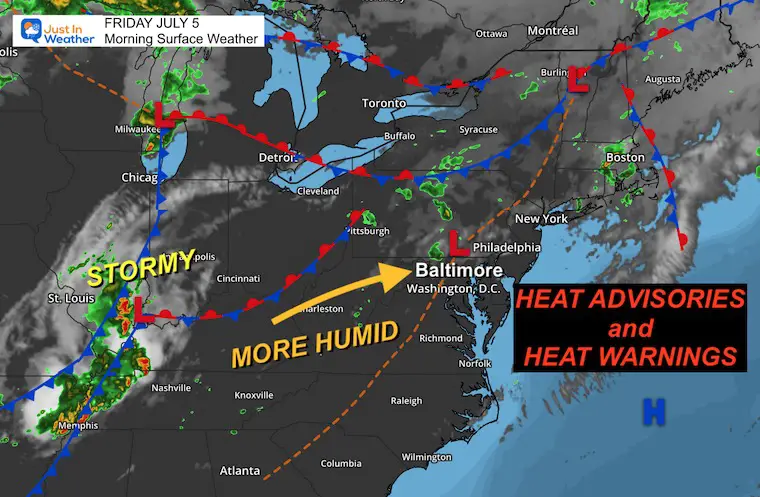
Morning Surface Weather
A simple shift in wind within this air mass will allow a little more heat and humidity in place. This is when it becomes less comfortable to dangerous.
Some showers and thunderstorms may develop, but they are not the focus today. It will be for our region tomorrow.
Afternoon Temperatures
Close to matching the Record High
Heat Index
CLIMATE DATA: Baltimore
TODAY July 5
Sunrise at 5:45 AM
Sunset at 8:36 PM
Normal Low in Baltimore: 67ºF
Record 53ºF in 1986
Normal High in Baltimore: 89ºF
Record 100ºF 1898, 1966, 2002
See More On Aphelion Day at: Time and Date
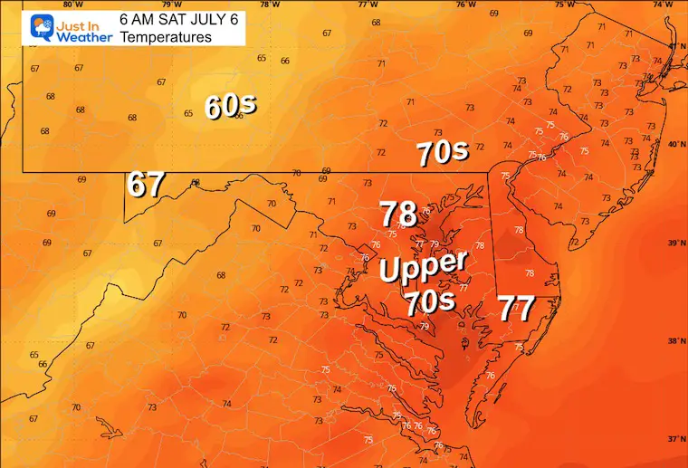
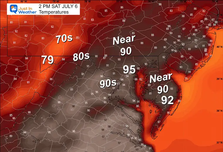
SATURDAY JULY 6
Hot and Humid!
Morning Temperatures
Afternoon Temperatures
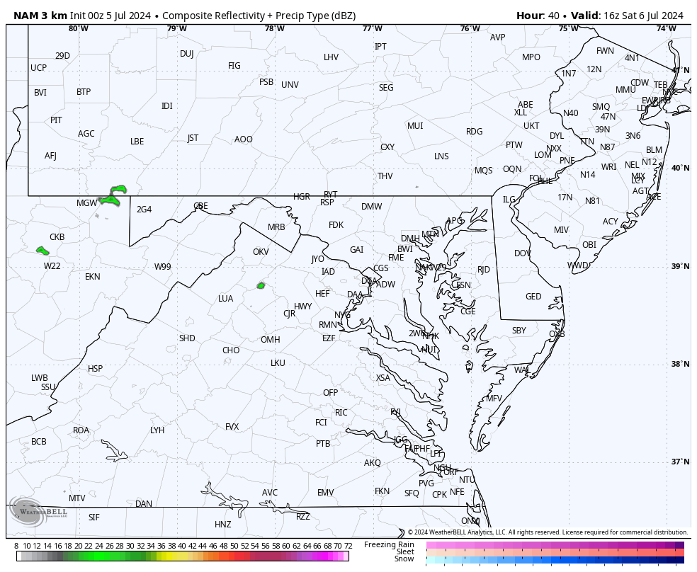
Radar Simulation: Noon to Midnight
Showers and thunderstorms develop mid-afternoon. This suggestion has a line of storms reaching metro areas between 3 PM and 8 PM.
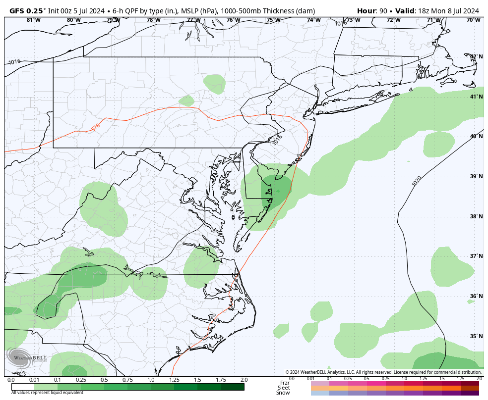
Looking Ahead: Monday to Thursday
Almost every day will bring showers and thunderstorms in the afternoon and evening.
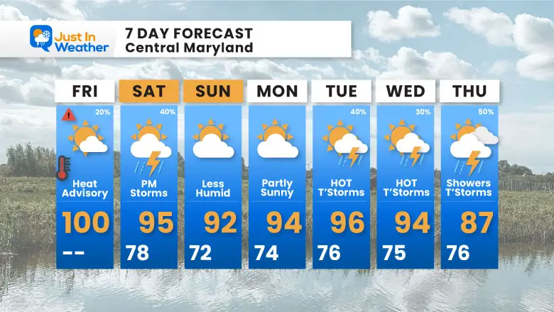
7 Day Forecast
There will be little relief over the next week. If anything, we will get a few days with lower humidity, but it will remain hot!
Please share your thoughts and best weather pics/videos, or just keep in touch via social media
RESTATING MY MESSAGE ABOUT DYSLEXIA
I am aware there are some spelling and grammar typos and occasional other glitches. I take responsibility for my mistakes and even the computer glitches I may miss. I have made a few public statements over the years, but if you are new here, you may have missed it: I have dyslexia and found out during my second year at Cornell University. It didn’t stop me from getting my meteorology degree and being the first to get the AMS CBM in the Baltimore/Washington region.
One of my professors told me that I had made it that far without knowing and to not let it be a crutch going forward. That was Mark Wysocki, and he was absolutely correct! I do miss my mistakes in my own proofreading. The autocorrect spell check on my computer sometimes does an injustice to make it worse. I also can make mistakes in forecasting. No one is perfect at predicting the future. All of the maps and information are accurate. The ‘wordy’ stuff can get sticky.
There has been no editor who can check my work while writing and to have it ready to send out in a newsworthy timeline. Barbara Werner is a member of the web team that helps me maintain this site. She has taken it upon herself to edit typos when she is available. That could be AFTER you read this. I accept this and perhaps proves what you read is really from me… It’s part of my charm. #FITF


