October 6 Weather Still Warm And Damp Tracking Narrow Band Of Rain
Wednesday October 6
This morning begins with fog and mist.
We are stuck in this ambiguous pattern. The sky is cloudy, the air is warm and damp. There will not be much change in this pattern for a few days. The only thing we can watch is where this front is located and how it may wonder or meander to trigger rain.
Morning Surface Weather
The instigator for showers and storms remains along that stalled front to our south.

Morning Temperatures

Afternoon Temperatures

More Showers
7 AM to 8 PM
This is all about where that front is located. Once again, a round of showers and some storms will develop today. It looks like a better chance near Annapolis and through Southern Maryland.

Weather Almanac: Climate Data
TODAY October 6
Normal Low in Baltimore: 49ºF
Record 33ºF in 1965
Normal High in Baltimore: 70ºF
Record 95º F 1945
Temperatures Thursday
Morning

Afternoon

Also See:
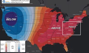
Temperature Outlook Above Normal Through Mid October
Tracking The Rain
Thursday through Sunday afternoon
The front should shift north and focus the rain in the mountains Friday and Saturday.
On Sunday, a more organized Low Pressure should help to enhance the risk of rain for more of the region.

7 Day Forecast

Maryland Trek Gear
Maryland Trek 8 Says THANK YOU!
Running Total Raised $116,438
During 329 Miles From Wisp To Ocean City
To Honor Kids In Cancer Treatment and Support FREE Programs At Just In Power Kids
Please share your thoughts, best weather pics/video, or just keep in touch via social media
Facebook: Justin Berk, Meteorologist
Twitter: @JustinWeather
Instagram: justinweather


