Howard County EF1 Tornado 100 mph Winds And Other May 30 Storm Reports
May 31 2019
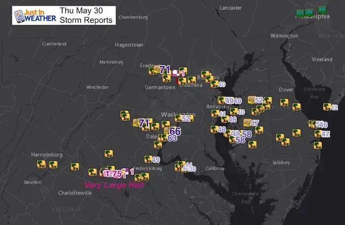
The active weather has brought the National Weather Service back to Howard County for the second time in the past week. The official survey crew investigated the tornado in Glenelg that was confirmed by Doppler Radar and possible on the video here as well. This was among many other storm reports across our region. Below is a list of all reports for Thursday May 30 2019. These include tree damage and wind gusts.
[adrotate group=”4″]
NWS Preliminary Results
A full report will be available this event. I have more information below.
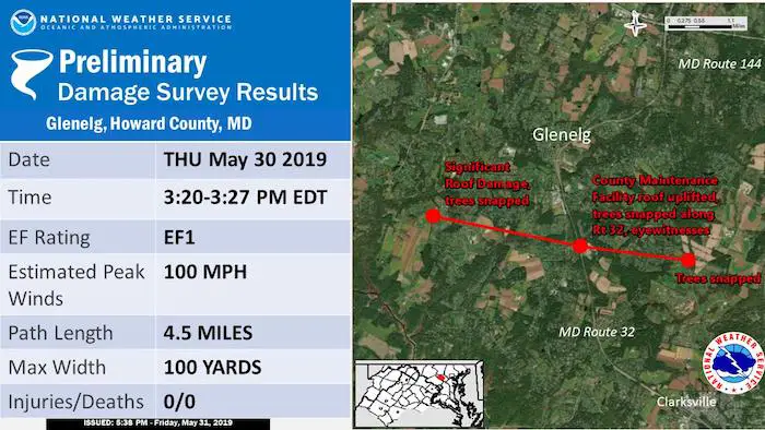
EF Tornado in Glenelg
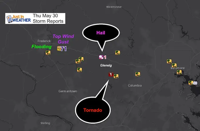
As I had mentioned online, the hail is often in a different location of the storm cell than the tornado. In this case, it was located to the north. I showed that on the Doppler Image snapshot and reposted that below.
Doppler Radar Loop
This cell produced flooding in the city of Frederick. as it moved east. But watch the cell along I-95 moving between Silver Spring, Glen Burnie and Baltimore. That shows movement to the northeast, while the Frederick storm was moving to the east-southeast.
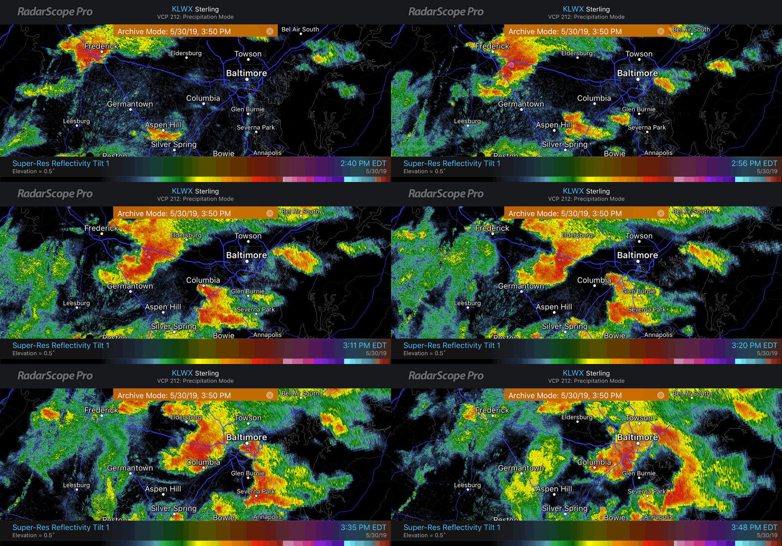
I’ve annotated a key frame here to illustrate what is in the loop above. This was an indication of wind sheer in the atmosphere. The wind flow ahead of the Frederick cell helped to give this storm rotation and drop the funnel cloud.
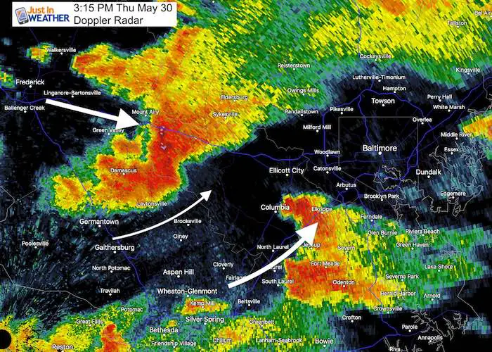
The Velocity Scan of Doppler Radar shows the rotation hook and funnel.
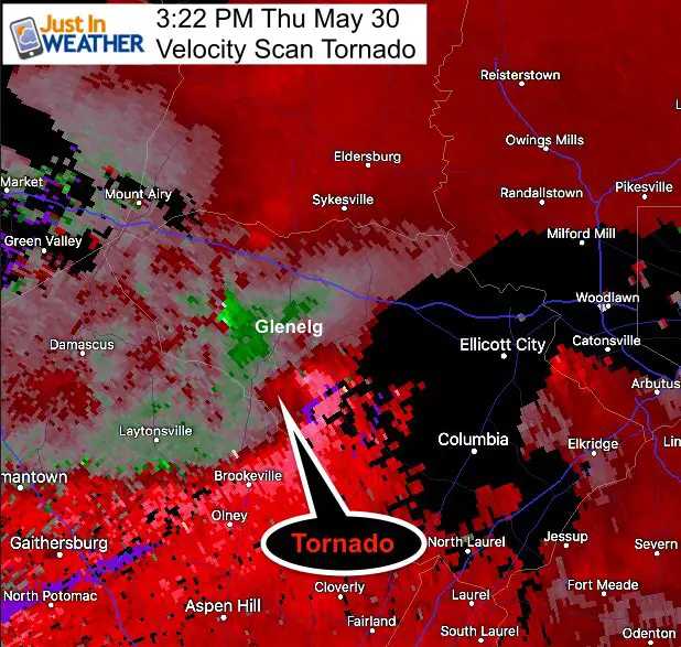
The Doppler Radar standard return you are use to seeing shows that hail fell to the north, which is often on a different side of the storm cell.
[adrotate group=”4″]
Here is JP Arnold capturing what he believes was the tornado touching down within a 100 yards of him pulling over
[adrotate group=”4″]
Do You Remember???
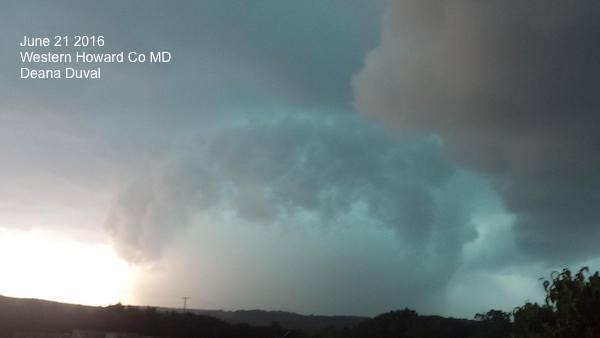
June 21, 2016 – The Woodbine Tornado
Click the image for that report and video from Modern F0undations
Other Storm Reports
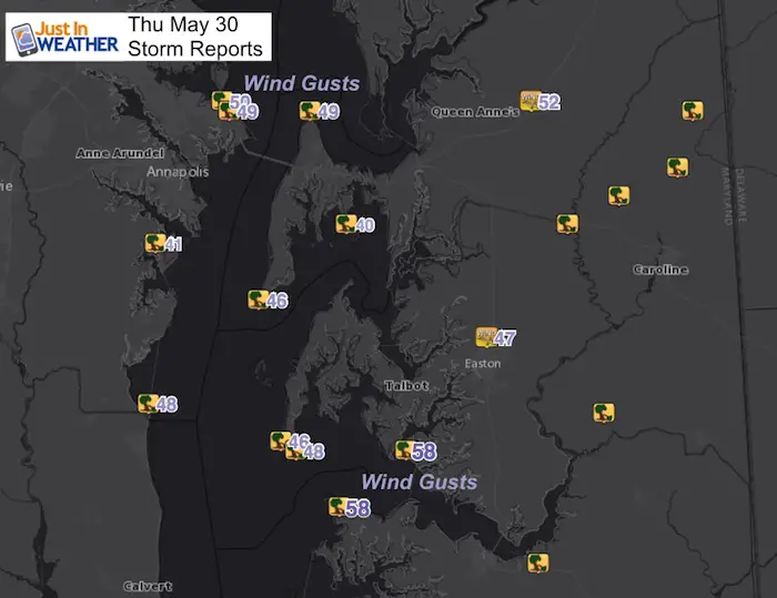
| 3 ESE BALLENGER CREEK | FREDERICK | MD | 3936 | 7739 | TREE DOWN ON THE 4600 BLOCK OF ARABY CHURCH ROAD. (LWX) |
| DAMASCUS | MONTGOMERY | MD | 3928 | 7720 | SEVERAL REPORTS OF TREES AND WIRES DOWN. (LWX) | ||
| 1906 | UNK | 1 NNW FRIENDSHIP | MONTGOMERY | MD | 3932 | 7721 | TREE DOWN ON THE 28600 BLOCK OF KEMPTOWN ROAD. (LWX) |
| 1906 | UNK | 2 NNE FRIENDSHIP | MONTGOMERY | MD | 3933 | 7719 | TREE DOWN ON THE 29010 BLOCK OF RIDGE ROAD. (LWX) |
| 1926 | UNK | 1 NNE DAYTON | HOWARD | MD | 3925 | 7698 | ROOF DAMAGE TO A SHOP IN THE 400 BLOCK OF ROUTE 32. (LWX) |
| 1926 | UNK | 1 SSE SYKESVILLE | HOWARD | MD | 3936 | 7697 | ROOF DAMAGE TO A SHOP IN THE 400 BLOCK OF ROUTE 32. (LWX) |
| 1 WSW BALTIMORE | BALTIMORE CITY | MD | 3930 | 7663 | TRAFFIC POLE DOWN NEAR THE INTERSECTION OF MARTIN LUTHOR KING JR. BLVD AND PENNSYLVANIA AVE. (LWX) |
| 1 SW ELLICOTT CITY | HOWARD | MD | 3926 | 7685 | TREE DOWN ON HOUSE ON RIVERSIDE CIRCLE. MULTIPLE TREES DOWN IN THE AREA. (LWX) |
| 1 WSW BALTIMORE | BALTIMORE CITY | MD | 3930 | 7663 | FREE-STANDING TRAFFIC LIGHT DOWN AT INTERSECTION OF MARTIN LUTHER KING BLVD AND PENNSYLVANIA AVE PER BALTIMORE SUN IMAGE. (LWX) |
| 3 WSW PARK HEIGHTS | BALTIMORE CITY | MD | 3932 | 7666 | SEVERAL TREES DOWN IN THE AREA (LWX) | ||
| 1951 | UNK | FORESTVILLE | PRINCE GEORGES | MD | 3885 | 7688 | TREE DOWN ON A HOUSE IN THE 3200 BLOCK OF MAYGREEN AVENUE. (LWX) |
| 2 W FELLS POINT | BALTIMORE CITY | MD | 3927 | 7660 | TELEPHONE PHONE POLES DOWN ON KEY HIGHWAY NEAR MCCOMAS STREET. (LWX) |
| QUEEN ANNE | QUEEN ANNES | MD | 3892 | 7596 | REPORTS OF TREES DOWN AND POWER OUTAGES NEAR THE QUEEN ANNE AREA ALONG THE QUEEN ANNES AND TALBOT COUNTY BORDER. TIME ESTIMATED FROM RADAR. (PHI) |
| RIDGELY | CAROLINE | MD | 3895 | 7589 | TREES AND WIRED DOWN IN RIDGELY. TIME BASED ON RADAR. |
| GREENSBORO | CAROLINE | MD | 3898 | 7581 | TREES AND WIRES DOWN IN GREENSBORO. TIME ESTIMATED BY RADAR. (PHI) |
| GOLDSBORO | CAROLINE | MD | 3904 | 7579 | TREES AND WIRED DOWN IN GOLDSBORO. TIME ESTIMATED BY RADAR. (PHI) |
| PRESTON | CAROLINE | MD | 3872 | 7591 | WIRES DOWN IN PRESTON. TIME ESTIMATED BY RADAR. (PHI) |
| 4 WNW LINKWOOD | DORCHESTER | MD | 3856 | 7600 | TREES DOWN JUST EAST OF CAMBRIDGE. (AKQ) |
Keep In Touch Every Day
Just in case you don’t get all posts on your social media feed, stay up to date with the latest info…
Click here to sign up for email alerts…. Be the first to hear any new weather.
Join My Team: Maryland Trek 6
Our look got an upgrade, but we have the same purpose. Please click the logo take a look at our new page.
- Consider joining our team for the week, a single day, or even as a sponsor.
Support Our Nonprofit:
Proceeds go to our programs Providing FREE holistic care for kids in cancer treatment and up to 5 years post treatment and caregivers.

Shine On
Proceeds from all sales go to Just In Power Kids. Click the image to shop and show your support.
Love Maryland Shirts and Hoodies
This shirt was designed by my ‘bonus’ daughter Jaiden. The hoodie has been the biggest hit, so our promotion has been extended until the end of this week.
|
||
|
Show your love for Maryland and make this 14 year old artist and her mom extra proud
|
Please share your thoughts, best weather pics/video, or just keep in touch via social media
-
Facebook: Justin Berk, Meteorologist
-
Twitter: @JustinWeather
-
Instagram: justinweather
[adrotate group=”4″]


