Tuesday Morning December 9
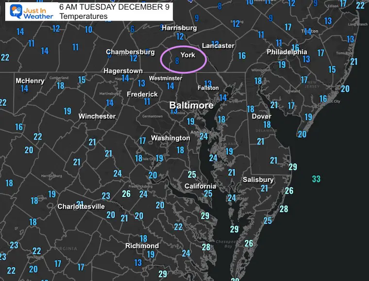
This is the coldest we have been in our region since January. With temps down into the teens in Baltimore, we compare to last winter. It was 17°F on Feb 19; even colder, 13℉ on January 25.
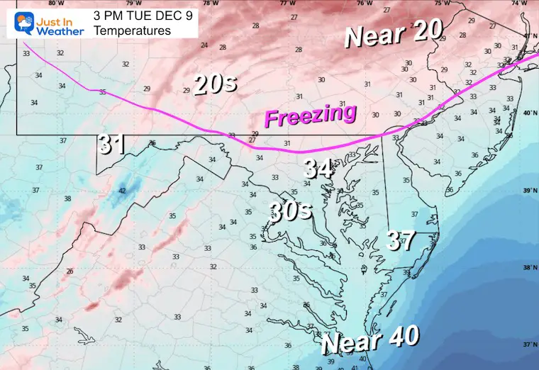
The region is averaging 15℉ below average, and that will remain even though we aim close to freezing/thaw this afternoon.
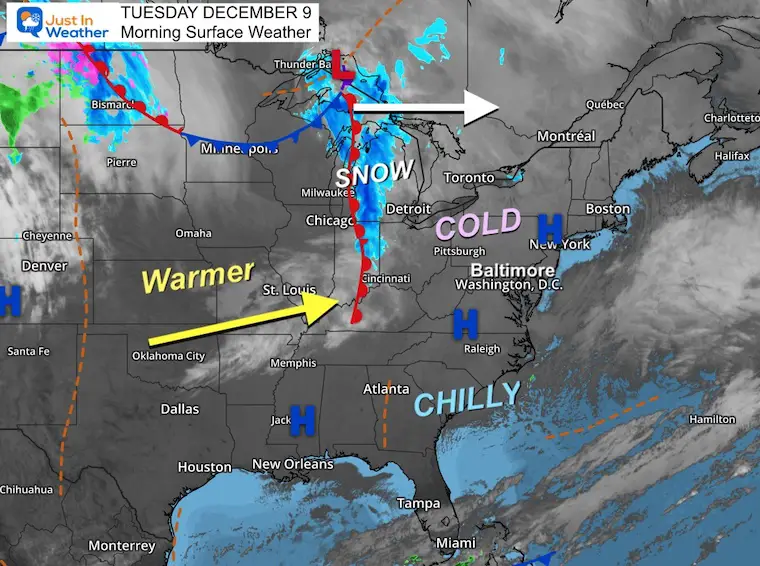
The next system will arrive tomorrow morning, and the timing may be early enough for a light sleet or freezing rain risk mainly NORTH of the city. Then we warm just enough for light rain during the day.
This will bring a fresh few inches of snow to Wisp Resort, which has now opened its ski season. I included a live camera below.
This weekend, there will be two more clipper-like storms as we will be on the edge of the influence from the Polar Vortex lobe swinging south.
I have been posting on social media about the uncertainty. The computer model guidance is having trouble resolving how this weekend will play out. We know there will be two impulses, and now it looks like the second will be stronger. But also, as I expected, each new model run is very different. Below is a comparison of the latest look.
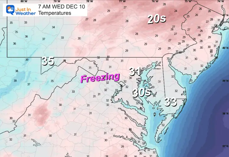
Morning Temperatures
Morning Surface Weather
LIVE CAM:
Wisp Ski Resort at Deep Creek Lake in McHenry Maryland.
This webcam is positioned at The Greene Turtle Deep Creek Lake and shows Wisp Resort, including a zoomed-in view of Squirrel Cage, The Face, the terrain park, Boulder, the mountain coaster, the tubing park, and a shot of McHenry Cove at Deep Creek Lake!
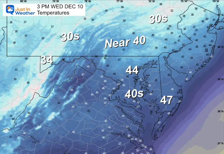
Afternoon Temperatures
Subscribe for eMail Alerts
If It Snows On Christmas: Jarrettsville Furniture Special
CLIMATE DATA: Baltimore
Yesterday: Low 24F; High 35F
Precipitation: 0.00”
Snow = 0
Season Snow Total: 1.0″
Top Wind Gust: 28 mph
TODAY December 9
Sunrise at 7:15 AM
Sunset at 4:44 PM
Normal Low in Baltimore: 31ºF
Record 4ºF in 1876
Normal High in Baltimore: 49ºF
Record 73ºF 1966
Rainfall Deficit at BWI
- Ending 2024 = -8.00”
- Since Jan 1 = 6.87”
- We are STILL DOWN -14.87” INCLUDING LAST YEAR
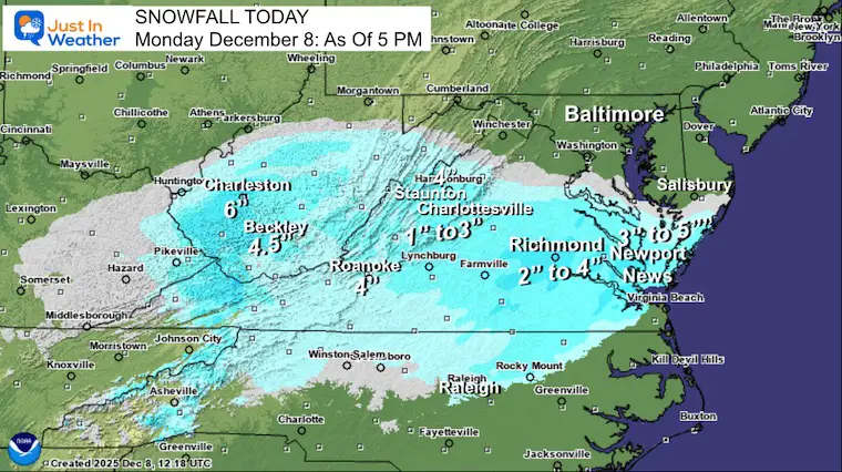
Snow Report: Virginia
This was as of 5 PM Yesterday. The final numbers will be available today.
Snow Report December 5 to 6 and Grade My Forecast
In case you missed it. The brief summary of the final snow totals from the last event.

FAITH IN THE FLAKES STORE
NOW OPEN FOR THE SEASON
click here

WEDNESDAY
Temps will be hovering close to freezing as the next weather system arrives. There will be a band of precipitation developing on the edge of the freezing line, and if early enough, it may catch up and bring some freezing drizzle or sleet, mainly NORTH of Baltimore, for a couple of hours around sunrise.
Morning Temperatures
Afternoon Temperatures
Central Maryland will rise above freezing, while Western Maryland will remain cold enough for snow.
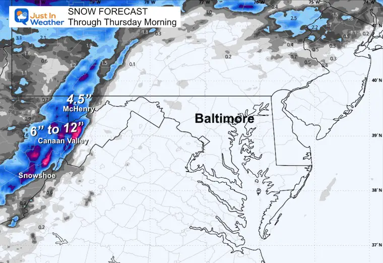
Snow Totals By Thursday Morning
McHenry may receive 4 inches or more of fresh powder.
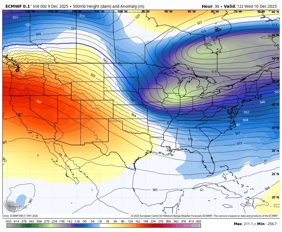
Looking Ahead: Jet Stream
500mb Height Anomaly: Wednesday to Monday
The core cold air will relax, then be reinforced by the next push later in the weekend.
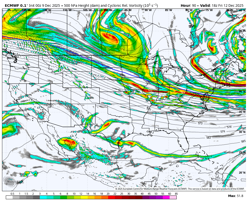
500mb Vorticity: Friday to Monday
Multiple impulses of energy will ride on the edge of the arctic air. This is the challenging part: Where will the energy track… the net result will determine the impact of rain or snow for us.
Over the weekend I wrote a report discussing this and how computer model guidance supports the likelihood that something will happen. What that ‘something’ is has changed with each model run.
Just yesterday we saw the flip, and I expect we will see more inconsistency for another 24 hours.
Model Comparison FROM Monday Morning
This run supported a snow event with the second clipper from Saturday night to Sunday morning. At least the European and GFS Models were there and the Canadian tracked farther north.
Model Comparison FROM Monday Night
This run shifted the clipper north. While the GFS is hanging on to the snow solution for Maryland, the European ECMWF and Canadian Models tracked north. That is warmer and a rain track for Maryland.
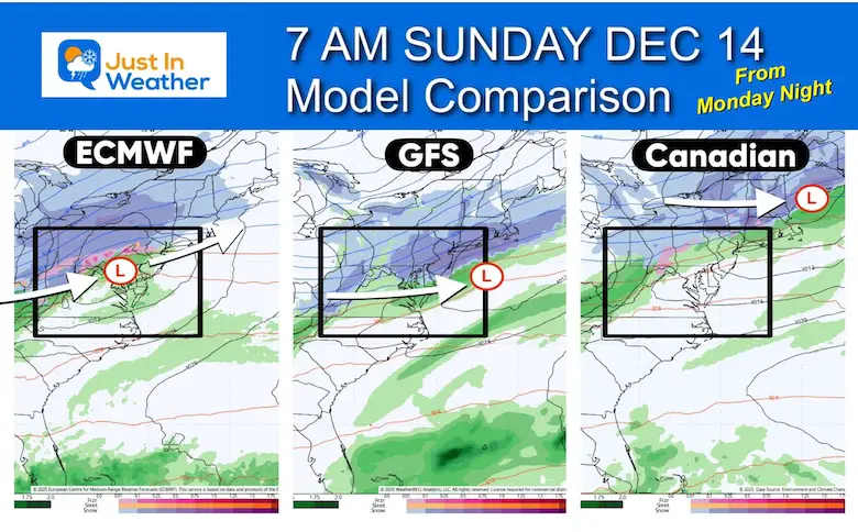
Take Away:
I have seen the Canadian Model for over a decade work best in arctic patterns. In this case, I did not believe the north track. The ECWMF Model is seemingly tracking that way.
But it is too soon to lock in on that. I expect there will be more adjustments as the jet stream energy is not identified well.
Today I will be looking for any consistent trend north or inconsistent bounce back south, or timing again.
Computer Models are guidance but NOT perfect. This is why I DO NOT show snow totals more than 3 days away… and the outlook for weeks ahead is purely entertainment.
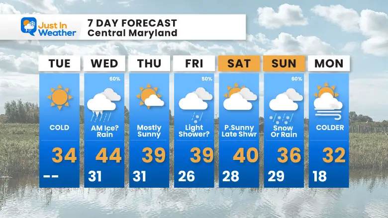
7 Day Forecast
Subscribe for eMail Alerts
My Winter Outlook For Above-Average Snow
Click here for the full report

La Niña Advisory
This was issued October 9, as expected: A weak and short-lived event to start winter may play a different role this winter.

In Case You Missed It
Woolly Bear Caterpillar Winter Folklore
These are NOT all the same caterpillar!

Winter Outlook From 2 Farmers’ Almanacs

STEM Assemblies/In School Fields Trips Are Back
Click to see more and ‘Book’ a visit to your school

THANK YOU:
Baltimore Sun Magazine Readers’ Choice Best Of Baltimore

Maryland Trek 12 Day 7 Completed Sat August 9
UPDATED: We raised OVER $170,000 for Just In Power Kids – AND Still Collecting More
The annual event: Hiking and biking 329 miles in 7 days between The Summit of Wisp to Ocean City.
Each day, we honor a kid and their family’s cancer journey.
Fundraising is for Just In Power Kids: Funding Free Holistic Programs. I never have and never will take a penny. It is all for our nonprofit to operate.
Click here or the image to donate:

RESTATING MY MESSAGE ABOUT DYSLEXIA
I am aware there are some spelling and grammar typos and occasional other glitches. I take responsibility for my mistakes and even the computer glitches I may miss. I have made a few public statements over the years, but if you are new here, you may have missed it: I have dyslexia and found out during my second year at Cornell University. It didn’t stop me from getting my meteorology degree and being the first to get the AMS CBM in the Baltimore/Washington region. One of my professors told me that I had made it that far without knowing and to not let it be a crutch going forward. That was Mark Wysocki, and he was absolutely correct! I do miss my mistakes in my own proofreading. The autocorrect spell check on my computer sometimes does an injustice to make it worse. I can also make mistakes in forecasting. No one is perfect at predicting the future. All of the maps and information are accurate. The ‘wordy’ stuff can get sticky. There has been no editor who can check my work while writing and to have it ready to send out in a newsworthy timeline. Barbara Werner is a member of the web team that helps me maintain this site. She has taken it upon herself to edit typos when she is available. That could be AFTER you read this. I accept this and perhaps proves what you read is really from me… It’s part of my charm. #FITF
Please share your thoughts and best weather pics/videos, or just keep in touch via social media.


