Saturday December 6
The second winter weather event in a week was the one that left a true impact. This was the first snow of the season for Baltimore and the first measurable snow above a trace in December since 2020.
The December 5th snow matched the kick off of winter snow with most of the winters between 2002 and 2011.
I was all ready to call this a victory, but for some areas the snow kept falling all Friday into Saturday Morning.
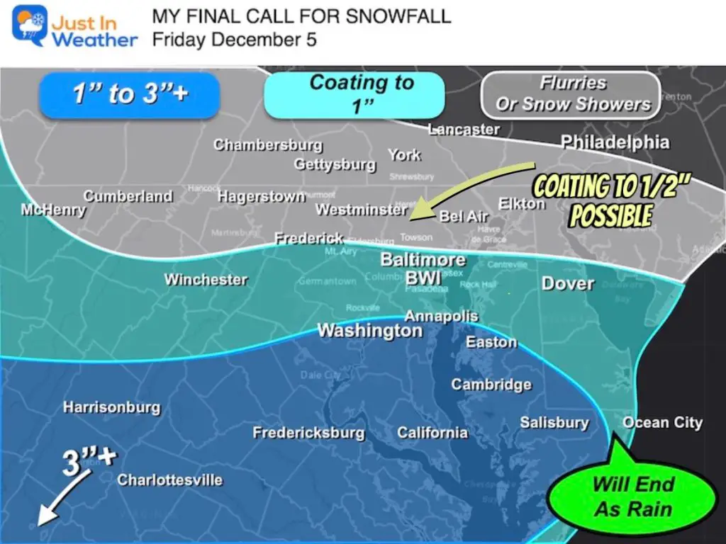
While the final snow map matched up very well with my official call for snowfall, there were some mistakes I made.
My brief account here will include many local snow maps and a list of all the spotter reports from NWS Baltimore/Washington region.
What I did wrong:
- My first call was for snow Friday Afternoon to Evening. I adjusted this to morning with a full day notice ahead of time.
- I expected the snow to fade during the afternoon based on the HRRR model. Instead light snow lasted overnight and into the morning.
- Freezing Drizzle was expected with the Second Winter Weather Advisory Friday night. Instead the air remained cold enough for more snow that brought a coating to 1 inch to some.
What I did right:
- My Call For snowfall was close to perfect. You can compare below.
- I expected impact on the roads in the morning near and South of Rt 70. This ended up being a bigger problem for metro Washington and Frederick City to southern Carrol County.
- So how did I do? I am once again reserving the prime voting to my Facebook Post where it is easiest to log.
Computer Model Notes
- This was generated by a jet streak we mapped coming out of the Southern Rockies for a couple of days.
- This did track a little north as we got closer.
- The HRRR Model did a better job with the north end on Friday, but ended the snow too soon.
- The NAM 3Km Model expanded the snow too far north, but did a better job with the lingering moisture later in the day.
- The late night resurgence of snow/freezing rain was a late call.
EXPLORE MORE:
Why December 5th is so special for Baltimore Snow AND The Origin Of Faith In The Flakes Back in 2009
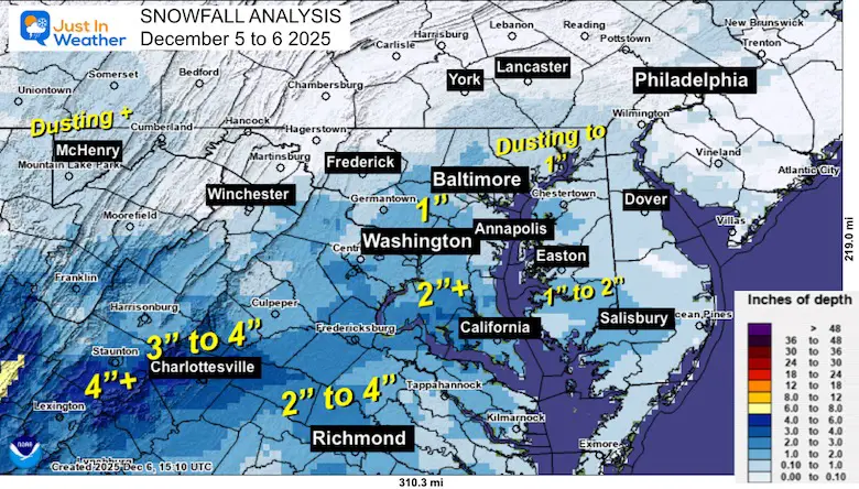
Let’s Look At The Snow Maps
Snowfall Analysis: Saturday Morning December 6
My Final Call For Snowfall
My Facebook Post and Grades
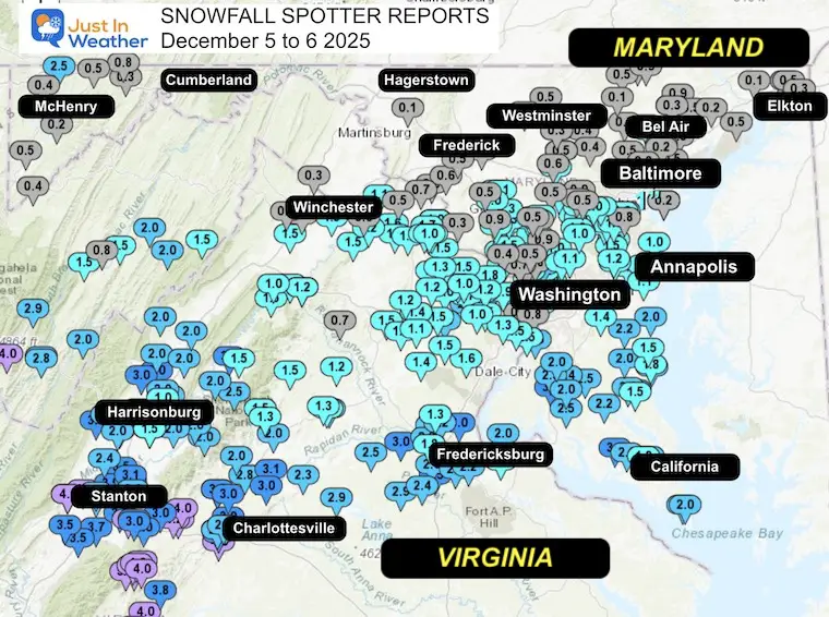
Snow Spotter Reports
These are from the NWS Baltimore Washington Office Coverage Area
Region Map
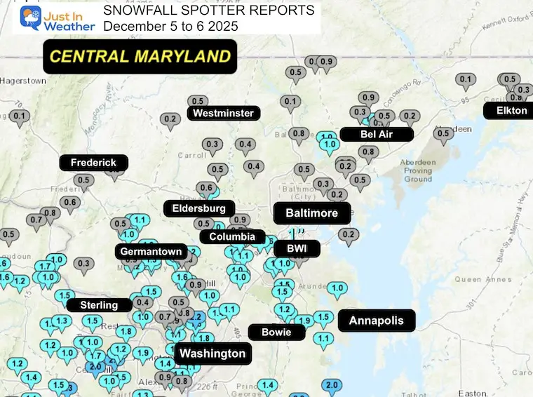
Central Maryland
The coating to 1 inch Inn Northeastern Maryland mostly fell Friday night to Saturday morning.
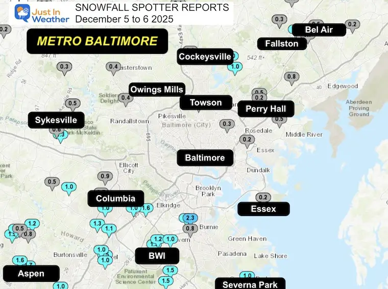
Metro Baltimore
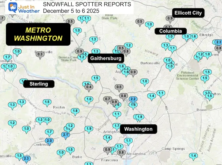
Metro Washington
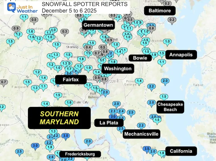
Southern Maryland
Subscribe for eMail Alerts
Snow Spotter List
**********STORM TOTAL SNOWFALL (AT LEAST 0.0 INCH)**********
LOCATION TOTAL TIME/DATE COMMENTS
SNOWFALL MEASURED (inches)
DISTRICT OF COLUMBIA
…District of Columbia…
- Catholic University 1.8 214 PM 12/05 NWS Employee
- Washington 3 NE 1.8 700 AM 12/06 CoCoRaHS
- Washington 4 N 1.6 700 AM 12/06 CoCoRaHS
- American University 1.1 1100 AM 12/05 Broadcast Media
MARYLAND
…Allegany County…
- Frostburg 0.3 700 AM 12/06 Co-Op Observer
…Anne Arundel County…
- Ferndale 1 WSW 2.3 509 PM 12/05 Trained Spotter
- Churchton 1 ENE 2.0 1230 PM 12/05 Trained Spotter
- Crownsville 3 SSW 1.9 1200 PM 12/05 Trained Spotter
- Parole 1.5 230 PM 12/05 Dept of Highways
- Odenton 1 N 1.5 1045 AM 12/05 CoCoRaHS
- Odenton 1.5 530 PM 12/05 Public
- Crofton 1 SSE 1.5 1127 AM 12/05 NWS Employee
- Severn 2 W 1.3 700 AM 12/06 CoCoRaHS
- Severn 1 W 1.2 600 AM 12/06 CoCoRaHS
- Crofton 2 NNE 1.2 107 PM 12/05 NWS Employee
- Londontowne 1 SSE 1.1 220 PM 12/05 Trained Spotter
- Severn 1.0 1121 AM 12/05 Public
- Arnold 2 N 1.0 800 AM 12/06 CoCoRaHS
- Bwi Airport 1.0 1200 AM 12/06 Official NWS Obs
- Baltmore-Washington 0.8 230 PM 12/05 Dept of Highways
…Baltimore County…
- Long Green 2 NW 1.0 730 AM 12/06 Trained Spotter
- Long Green 1 SW 1.0 700 AM 12/06 CoCoRaHS
- Kingsville 1 E 0.8 700 AM 12/06 CoCoRaHS
- Cockeysville 2 NNW 0.8 958 AM 12/06 Broadcast Media
- Edgemere SE 0.8 446 AM 12/06 Trained Spotter
- White Marsh 2 ESE 0.5 700 AM 12/06 CoCoRaHS
- Norrisville 3 W 0.5 400 PM 12/05 Trained Spotter
- Perry Hall 1 NNE 0.5 1215 PM 12/05 Trained Spotter
- Bentley Springs 1 E 0.5 655 AM 12/06 Trained Spotter
- Towson 1 SW 0.5 830 AM 12/06 CoCoRaHS
- Glyndon 1 WSW 0.4 1251 PM 12/05 Trained Spotter
- Owings Mills 0.4 230 PM 12/05 Dept of Highways
- Rosedale 1 E 0.2 230 PM 12/05 Dept of Highways
- Edgemere 0.2 1052 AM 12/05 Trained Spotter
- Perry Hall ENE 0.2 600 AM 12/06 CoCoRaHS
- Bentley Springs 6 S 0.1 230 PM 12/05 Dept of Highways
…Baltimore City…
- Hamilton NE 0.3 800 AM 12/06 CoCoRaHS
…Calvert County…
- Prince Frederick 1 S 3.0 230 PM 12/05 Dept of Highways
- Dunkirk 3.2NNE 2.2 800 AM 12/06 CoCoRaHS
- Dares Beach 4 N 2.0 200 PM 12/05 Trained Spotter
- Prince Frederick 1 W 2.0 800 AM 12/06 CoCoRaHS
- Huntingtown 3 NNW 2.0 800 AM 12/06 CoCoRaHS
- Chesapeake Beach 4 S 1.8 1258 PM 12/05 Amateur Radio
- Chesapeake Beach 1.5 911 AM 12/05 Trained Spotter
- Benedict 5 ENE 1.5 1000 AM 12/05 CoCoRaHS
…Carroll County…
- Eldersburg 1 E 1.2 700 AM 12/06 CoCoRaHS
- Gamber 1 W 0.9 700 AM 12/06 CoCoRaHS
- Westminster 1 NNE 0.5 230 PM 12/05 Dept of Highways
- Eldersburg 1 ESE 0.5 935 AM 12/05 Trained Spotter
- Gamber 1 WNW 0.3 1215 PM 12/05 CoCoRaHS
- Marston 2 N 0.2 700 AM 12/06 CoCoRaHS
…Cecil County…
- Elkton 2 W 0.8 230 PM 12/05 Dept of Highways
- Elkton 5 NW 0.6 700 AM 12/06 CoCoRaHS
- Pleasant Hill 2 SE 0.5 1200 PM 12/05 Trained Spotter
- Elkton 1 NNW 0.3 800 AM 12/05 CoCoRaHS
- Woodlawn 2 ENE 0.1 759 AM 12/06 Trained Spotter
…Charles County…
- La Plata 2 NNW 3.0 230 PM 12/05 Dept of Highways
- La Plata 6 SE 2.5 1000 AM 12/05 CoCoRaHS
- Bryantown 2 NE 2.5 700 AM 12/06 CoCoRaHS
- Waldorf 3 S 2.4 800 AM 12/06 CoCoRaHS
- White Plains 2.3 155 PM 12/05 Trained Spotter
- Nanjemoy 5 S 2.0 700 AM 12/05 CoCoRaHS
- La Plata 3 ENE 2.0 300 PM 12/05 Trained Spotter
- Waldorf 2 W 2.0 935 AM 12/05 Trained Spotter
…Frederick County…
- Point of Rocks 1 NE 0.8 915 AM 12/05 Trained Spotter
- Adamstown 1 ESE 0.6 1000 AM 12/05 NWS Employee
- New Market 2 NW 0.5 730 PM 12/05 CoCoRaHS
- Ballenger Creek 1 E 0.5 230 PM 12/05 Dept of Highways
…Garrett County…
- Grantsville 5 W 2.5 635 AM 12/06 Dept of Highways
- Mount Savage 4 WNW 0.8 1130 PM 12/05 Trained Spotter
- Oakland 0.5 1039 AM 12/05 Dept of Highways
- Grantsville 4 E 0.5 1040 AM 12/05 Dept of Highways
- Accident NNE 0.4 830 PM 12/05 Trained Spotter
- Deer Park 6 NE 0.2 845 AM 12/05 Trained Spotter
…Harford County…
- Bel Air 2 W 1.0 700 AM 12/06 CoCoRaHS
- Norrisville 1 WSW 0.9 700 AM 12/06 CoCoRaHS
- Forest Hill 2 SW 0.9 845 AM 12/06 Trained Spotter
- Chrome Hill 2 SE 0.9 536 AM 12/06 Trained Spotter
- Bel Air 0.7 510 AM 12/06 Trained Spotter
- Bel Air 2 NE 0.5 1140 AM 12/05 Broadcast Media
- Aberdeen Proving Gro 0.5 200 PM 12/05 Trained Spotter
- Fallston 3 N 0.3 415 PM 12/05 Trained Spotter
- Churchville 1 SE 0.2 230 PM 12/05 Dept of Highways
…Howard County…
- Elkridge 1.6 1110 PM 12/05 NWS Employee
- Laurel 1 NNE 1.5 700 AM 12/06 CoCoRaHS
- Simpsonville 1 SSE 1.3 220 PM 12/05 Trained Spotter
- Sykesville 2 SSE 1.3 700 AM 12/06 CoCoRaHS
- Columbia 3 SSE 1.1 700 AM 12/06 CoCoRaHS
- Columbia 1.0 1000 AM 12/05 NWS Employee
- Clarksville 2 N 1.0 130 PM 12/05 Trained Spotter
- Laurel 2 N 1.0 1200 PM 12/05 Trained Spotter
- Elkridge 2 W 1.0 700 AM 12/06 CoCoRaHS
- Ellicott City 1 SW 0.9 815 AM 12/06 Trained Spotter
- Columbia 2 N 0.7 700 AM 12/06 CoCoRaHS
- Gaither 2 SE 0.6 1200 PM 12/05 Trained Spotter
- Dayton 1 NE 0.5 230 PM 12/05 Dept of Highways
- Columbia 2 NE 0.5 900 AM 12/05 Trained Spotter
…Montgomery County…
- Takoma Park 1 NNW 2.2 700 AM 12/06 CoCoRaHS
- Colesville 2 W 1.7 700 AM 12/06 CoCoRaHS
- Gaithersburg 2 E 1.7 700 AM 12/06 CoCoRaHS
- Somerset 1 ENE 1.6 245 PM 12/05 Trained Spotter
- Glenmont 2 NNE 1.6 245 PM 12/05 Trained Spotter
- Potomac 1 NNW 1.6 700 AM 12/06 CoCoRaHS
- Norbeck 1 ESE 1.6 700 AM 12/06 CoCoRaHS
- Olney 1.5 257 PM 12/05 Trained Spotter
- Olney 1 NE 1.5 230 PM 12/05 CoCoRaHS
- Gaithersburg 1.5 935 AM 12/05 Emergency Mngr
- Potomac 3 NE 1.5 700 AM 12/06 CoCoRaHS
- Washington Grove 1 N 1.3 1000 AM 12/05 Trained Spotter
- Montgomery Village 1 1.3 630 AM 12/06 CoCoRaHS
- Ashton-Sandy Springs 1.2 700 AM 12/06 CoCoRaHS
- Damascus 3 SSW 1.2 700 AM 12/06 Co-Op Observer
- Gaithersburg 1 SW 1.2 1015 AM 12/05 Trained Spotter
- Damascus 1 S 1.1 700 AM 12/06 CoCoRaHS
- Bradley Farms 1 SSW 1.0 1044 AM 12/05 NWS Employee
- Calverton 1 SW 1.0 230 PM 12/05 Dept of Highways
- Leesburg 4 NE 1.0 810 AM 12/05 Trained Spotter
- Clarksburg 2 SE 1.0 810 AM 12/05 Trained Spotter
- Dickerson 7 SW 1.0 810 AM 12/05 CoCoRaHS
- North Potomac 4 N 0.9 700 AM 12/06 CoCoRaHS
- Chevy Chase 1 SW 0.9 500 PM 12/05 CoCoRaHS
- Silver Spring 6 NNE 0.9 442 AM 12/06 CoCoRaHS
- Sandy Springs 2 W 0.8 800 AM 12/05 CoCoRaHS
- Silver Spring 0.8 830 AM 12/05 Local Official
- Bethesda 0.7 835 AM 12/05 Emergency Mngr
- Clarksburg 1 N 0.5 743 AM 12/05 Emergency Mngr
- Olney 1 ENE 0.5 717 AM 12/06 CoCoRaHS
- Kensington W 0.5 800 AM 12/05 CoCoRaHS
- Potomac 0.4 839 AM 12/05 Emergency Mngr
- Poolesville 0.3 837 AM 12/05 Emergency Mngr
…Prince Georges County…
- Upper Marlboro 1 S 1.4 230 PM 12/05 Dept of Highways
- College Park 1.4 900 AM 12/05 CoCoRaHS
- Greenbelt 1 N 1.1 700 AM 12/06 CoCoRaHS
- Laurel 1 E 1.0 230 PM 12/05 Dept of Highways
…St. Marys County…
- Clements 3 E 3.5 230 PM 12/05 Dept of Highways
- Mechanicsville 4 N 2.2 700 AM 12/06 CoCoRaHS
- California 2 W 2.2 1125 AM 12/05 Trained Spotter
- Ridge 1 N 2.0 700 AM 12/06 CoCoRaHS
- Leonardtown 1 NE 2.0 600 AM 12/05 CoCoRaHS
- Ridge 1 E 2.0 1030 AM 12/05 Trained Spotter
- California 3 W 1.8 940 AM 12/05 Trained Spotter
…Washington County…
- Boonsboro 3 NNE 0.1 800 PM 12/05 Trained Spotter
FAITH IN THE FLAKES STORE
NOW OPEN FOR THE SEASON
click here

VIRGINIA
…Albemarle County…
Crozet 4.5 330 PM 12/05 Broadcast Media
Crozet 1 W 4.2 930 AM 12/05 Trained Spotter
Overton 3 NW 4.0 628 PM 12/05 Trained Spotter
Crozet 3 NNE 4.0 830 AM 12/05 Broadcast Media
Earlysville 4 NW 3.0 700 AM 12/05 CoCoRaHS
Charlottesville 2 W 3.0 858 AM 12/05 Co-Op Observer
Earlysville 3 NW 3.0 1028 AM 12/05 Trained Spotter
Charlottesville 3 NN 3.0 330 PM 12/05 Broadcast Media
Hollymead 3 NNW 3.0 730 AM 12/05 CoCoRaHS
…Arlington County…
Rosslyn W 1.7 1100 AM 12/05 Trained Spotter
Baileys Crossroads 1 1.6 1110 AM 12/05 Trained Spotter
Barcroft 1 WNW 1.4 946 AM 12/05 Trained Spotter
Reagan National Apt 1.1 1000 AM 12/05 Official NWS Obs
…Augusta County…
Trimbles Mill 2 NNE 5.0 836 PM 12/05 Public
Churchville 3 SSE 4.0 1000 AM 12/05 CoCoRaHS
Christian 2 SE 4.0 800 AM 12/05 Broadcast Media
Mint Spring 3 SSE 3.7 100 PM 12/05 Trained Spotter
Staunton Arpt 3 WSW 3.5 925 AM 12/05 Broadcast Media
Greenville 3.5 330 PM 12/05 Broadcast Media
Verona 3.5 330 PM 12/05 Broadcast Media
Waynesboro 4 WNW 3.5 330 PM 12/05 Broadcast Media
Summerdean 3 SE 3.5 1041 AM 12/05 Broadcast Media
Fort Defiance 4 SE 3.4 700 AM 12/05 CoCoRaHS
Fort Defiance 3 ESE 3.1 700 AM 12/05 CoCoRaHS
Greenwood 3 NNW 3.0 1145 AM 12/05 Public
Afton 1 WNW 3.0 1150 AM 12/05 Public
Mount Solon 4 SSE 2.4 730 AM 12/05 CoCoRaHS
Hermitage 3 N 2.0 622 AM 12/05 Trained Spotter
…City of Alexandria…
Alexandria 1 W 1.1 100 PM 12/05 Trained Spotter
Alexandria 1 ENE 1.1 100 PM 12/05 Trained Spotter
Alexandria 2 W 0.9 800 AM 12/05 CoCoRaHS
Alexandria 2 ESE 0.8 509 PM 12/05 Trained Spotter
…City of Charlottesville…
Charlottesville 2 SW 3.0 930 AM 12/05 Broadcast Media
Newcomb Hall 1 SW 2.8 840 AM 12/05 Trained Spotter
Charlottesville 1 NN 2.6 820 AM 12/05 Trained Spotter
Charlottesville 1 NN 2.0 700 AM 12/05 CoCoRaHS
…City of Fairfax…
Fairfax 1 N 2.1 630 AM 12/06 CoCoRaHS
…City of Fredericksburg…
Fredericksburg 3.2 700 AM 12/06 Co-Op Observer
Dunavant 1 S 3.0 1000 AM 12/05 Trained Spotter
Fredericksburg 2 E 1.8 1150 AM 12/05 Trained Spotter
…City of Harrisonburg…
Harrisonburg 2 N 3.0 900 AM 12/05 CoCoRaHS
…City of Staunton…
Staunton 1 WNW 3.0 700 AM 12/05 CoCoRaHS
Staunton 1 WSW 2.5 634 AM 12/05 CoCoRaHS
Staunton Water Plant 2.0 800 AM 12/05 Co-Op Observer
…City of Waynesboro…
Waynesboro 2 WNW 4.5 700 AM 12/05 CoCoRaHS
Waynesboro 3.3 845 AM 12/05 Broadcast Media
Waynesboro 1 SSE 3.0 757 AM 12/05 NWS Employee
…Clarke County…
Mount Weather 1.5 700 AM 12/05 Co-Op Observer
Berryville 1 NNW 1.5 800 AM 12/05 CoCoRaHS
…Culpeper County…
Culpeper 2.0 330 PM 12/05 Broadcast Media
Culpeper 1 W 1.4 1015 AM 12/05 Trained Spotter
Culpeper 2 WNW 1.3 900 AM 12/05 CoCoRaHS
Rixeyville 3 N 1.2 700 AM 12/06 CoCoRaHS
…Fairfax County…
Fairfax 2.0 1249 PM 12/05 Emergency Mngr
Tantallon 2 W 2.0 1250 PM 12/05 Trained Spotter
Oakton E 1.9 800 AM 12/06 CoCoRaHS
Falls Church 2 W 1.9 700 AM 12/06 CoCoRaHS
Vienna 3 N 1.8 700 AM 12/06 CoCoRaHS
Vienna 1.8 700 AM 12/06 Co-Op Observer
Chantilly 2 ENE 1.7 1244 PM 12/05 Trained Spotter
Alexandria 6 SSW 1.5 700 AM 12/06 CoCoRaHS
Herndon 1 NNE 1.5 200 PM 12/05 NWS Employee
Franconia 1 SSE 1.5 700 AM 12/06 CoCoRaHS
Fairfax 3 SSE 1.5 700 AM 12/06 CoCoRaHS
Springfield 2 SW 1.3 700 AM 12/06 CoCoRaHS
Herndon 4 SSW 1.3 700 AM 12/06 CoCoRaHS
Vienna 1 W 1.2 800 AM 12/06 CoCoRaHS
Centreville 3 NNW 1.0 902 AM 12/05 NWS Employee
Fairfax Station 1 N 1.0 905 AM 12/05 Trained Spotter
Herndon 3 S 1.0 700 AM 12/06 CoCoRaHS
…Fauquier County…
Broad Run 3 SSW 1.5 700 AM 12/06 CoCoRaHS
Greenwich 1 W 1.3 114 PM 12/05 Other Federal
Marshall 8 SW 0.7 700 AM 12/06 CoCoRaHS
…Frederick County…
Stephens City 2 E 1.5 1200 AM 12/06 CoCoRaHS
Winchester 3 E 0.9 845 AM 12/05 Trained Spotter
Winchester 1 WNW 0.3 819 AM 12/05 NWS Employee
…Greene County…
Ruckersville 2 E 4.0 700 AM 12/06 CoCoRaHS
Ruckersville 1 WNW 2.8 1230 PM 12/05 Trained Spotter
Stanardsville 2.0 1257 PM 12/05 Trained Spotter
…Highland County…
Monterey 4.0 1209 PM 12/05 Broadcast Media
Mustoe 4.0 700 AM 12/06 CoCoRaHS
Mill Gap 1 SW 3.2 1000 AM 12/05 Co-Op Observer
Hightown 5 NW 3.0 951 AM 12/05 Public
Hightown 3 NW 3.0 953 AM 12/05 Public
…King George County…
King George 1 WNW 1.5 339 PM 12/05 Fire Dept/Rescue
…Loudoun County…
Leesburg 2 NNE 1.7 845 AM 12/05 CoCoRaHS
Purcellville 1.6 830 AM 12/06 Co-Op Observer
Hughesville 2 W 1.6 918 AM 12/05 Trained Spotter
Ashburn N 1.5 700 AM 12/06 CoCoRaHS
Arcola 1 NNE 1.3 1040 AM 12/05 Trained Spotter
Dulles International 1.3 1200 AM 12/06 Official NWS Obs
Hughesville 1 ESE 1.2 200 PM 12/05 Trained Spotter
Round Hill 3 WSW 1.2 547 AM 12/06 CoCoRaHS
Arcola 3 S 1.2 1050 AM 12/05 Trained Spotter
Bloomery 3 ESE 1.1 100 PM 12/05 Trained Spotter
Leesburg 1 E 1.1 700 AM 12/05 NWS Employee
Leesburg 1.1 819 AM 12/05 NWS Employee
Leesburg 1 ESE 1.0 850 AM 12/05 Other Federal
Lovettsville 3 ESE 0.7 917 AM 12/05 CoCoRaHS
Hillsboro 3 NE 0.5 430 PM 12/05 Trained Spotter
…Madison County…
Big Meadows 2.5 1141 AM 12/05 Public
Madison 2.0 330 PM 12/05 Broadcast Media
Madison 7 NNW 1.5 700 AM 12/05 CoCoRaHS
Madison 5 NNW 1.3 800 AM 12/05 CoCoRaHS
…Nelson County…
Wintergreen 5.0 1015 AM 12/05 Law Enforcement
Wintergreen 2 WSW 5.0 1018 AM 12/05 Law Enforcement
Nellysford 2 N 5.0 700 AM 12/05 CoCoRaHS
Nellysford 2 WNW 4.6 725 AM 12/06 CoCoRaHS
Shipman 1 WNW 4.0 1000 AM 12/05 Trained Spotter
Nellysford 2 NW 4.0 1000 AM 12/05 CoCoRaHS
Wintergreen 1 ENE 4.0 900 AM 12/05 Broadcast Media
Rockfish 2 WNW 3.8 1015 AM 12/05 Trained Spotter
Arrington 3.5 741 AM 12/05 Trained Spotter
…Orange County…
Somerset 3.1 800 AM 12/05 Co-Op Observer
Barboursville 1 NW 3.0 930 AM 12/05 CoCoRaHS
Thornhill 2.9 420 PM 12/05 Trained Spotter
Gold Dale 3 N 2.5 330 PM 12/05 Broadcast Media
Orange 1 SSW 2.3 800 AM 12/05 Co-Op Observer
…Page County…
Luray 3.0 800 AM 12/05 Broadcast Media
Stanley 2 WSW 2.0 1000 AM 12/05 Trained Spotter
Luray 2 ESE 1.5 800 AM 12/05 CoCoRaHS
…Prince William County…
Manassas Park 1 NNW 2.3 1130 AM 12/05 Trained Spotter
Dale City 1 W 1.6 145 PM 12/05 Trained Spotter
Manassas 3 SSE 1.5 1015 AM 12/05 Trained Spotter
Manassas 3 NNW 1.5 800 AM 12/05 CoCoRaHS
Nokesville 4 S 1.4 700 AM 12/06 CoCoRaHS
Haymarket 2 ENE 1.4 800 AM 12/05 CoCoRaHS
Woolsey 1 SW 1.2 930 AM 12/05 Trained Spotter
Haymarket 4 SSE 1.1 700 AM 12/06 CoCoRaHS
…Rappahannock County…
Woodville 1.5 122 PM 12/05 Trained Spotter
…Rockingham County…
Clover Hill 3 WSW 3.0 932 AM 12/05 Broadcast Media
Broadway 3.0 1042 AM 12/05 Broadcast Media
Cherry Grove 3.0 948 AM 12/05 Dept of Highways
Clover Hill 2.7 545 AM 12/05 Broadcast Media
Bridgewater 2.5 700 AM 12/05 CoCoRaHS
Swift Run 2.0 1142 AM 12/05 Public
Harrisonburg 2.0 800 AM 12/05 Broadcast Media
Harrisonburg 9 NE 2.0 700 AM 12/06 CoCoRaHS
Elkton 2.0 330 PM 12/05 Broadcast Media
Bridgewater 1 NW 2.0 700 AM 12/05 CoCoRaHS
Timberville 3 NW 2.0 300 PM 12/05 Trained Spotter
Linville 4 ENE 2.0 330 PM 12/05 Broadcast Media
Massanutten 1 SE 2.0 1100 AM 12/05 Trained Spotter
Harrisonburg 4 SE 1.8 800 AM 12/05 CoCoRaHS
Harrisonburg 3 SE 1.5 846 AM 12/05 Broadcast Media
Harrisonburg 8 NE 1.0 700 AM 12/05 CoCoRaHS
…Shenandoah County…
Basye 2.0 922 AM 12/05 Broadcast Media
New Market 2.0 330 PM 12/05 Broadcast Media
Mount Jackson 2.0 330 PM 12/05 Broadcast Media
…Spotsylvania County…
Fredericksburg 5 SSW 3.5 600 AM 12/06 CoCoRaHS
Post Oak 1 W 2.9 211 PM 12/05 Trained Spotter
Fredericksburg 3 SW 2.6 700 AM 12/05 CoCoRaHS
Spotsylvania Courtho 2.4 130 PM 12/05 Trained Spotter
White Oak 4 SSW 2.0 731 AM 12/05 Trained Spotter
…Stafford County…
Stafford 3.0 1155 AM 12/05 Trained Spotter
Glendie 1 N 2.3 825 AM 12/05 Trained Spotter
Holly Corner 1 ENE 2.2 830 AM 12/05 NWS Employee
Ramoth 1 WSW 2.2 1250 PM 12/05 Trained Spotter
White Oak 3 SSE 2.2 700 AM 12/06 CoCoRaHS
Fredericksburg 4 NW 1.8 1123 AM 12/05 Public
Stafford 6 WNW 1.3 700 AM 12/05 CoCoRaHS
…Warren County…
Karo 1 WSW 1.5 900 AM 12/05 Trained Spotter
Front Royal 1.5 1143 AM 12/05 Public
Linden 3 W 1.3 1037 AM 12/05 Trained Spotter
Front Royal 3 ESE 1.2 1056 PM 12/05 CoCoRaHS
Front Royal 4 W 1.0 713 AM 12/05 Broadcast Media
WEST VIRGINIA
…Berkeley County…
Bunker Hill 2 SW 0.3 700 AM 12/05 CoCoRaHS
…Grant County…
Petersburg 1.5 902 AM 12/05 Co-Op Observer
Bayard 0.4 700 AM 12/06 Co-Op Observer
…Hardy County…
Bean Settlement 2.0 1054 AM 12/05 Dept of Highways
Baker 2.0 1052 AM 12/05 Dept of Highways
Moorefield 1.5 1051 AM 12/05 Dept of Highways
Wardensville 1.5 1055 AM 12/05 Dept of Highways
Rig NW 0.8 900 AM 12/05 CoCoRaHS
…Jefferson County…
Harpers Ferry 13 SSW 0.9 714 AM 12/06 CoCoRaHS
…Pendleton County…
Circleville 4.0 330 PM 12/05 Broadcast Media
Seneca Rocks 2.9 1014 AM 12/05 Public
Franklin 1 N 2.8 939 AM 12/05 Emergency Mngr
Franklin 2.8 947 AM 12/05 Dept of Highways
Fort Seybert 3 NE 2.0 600 AM 12/05 CoCoRaHS
************STORM TOTAL ICE (AT LEAST 0.00 INCH)************
LOCATION TOTAL TIME/DATE COMMENTS
ICE MEASURED
(inches)
MARYLAND
…Anne Arundel County…
Eastport 1 NNW 0.03 654 AM 12/06 ASOS
BWI Marshall Airport 0.01 654 AM 12/06 ASOS
…Calvert County…
Prince Frederick 1 W T 800 AM 12/06 CoCoRaHS
…Cecil County…
Pleasant Hill 2 SE T 700 AM 12/06 CoCoRaHS
…Garrett County…
Grantsville 5 W 0.10 635 AM 12/06 Dept of Highways
…Harford County…
Norrisville 1 WSW T 400 PM 12/05 CoCoRaHS
Fallston T 536 AM 12/06 Trained Spotter
…Howard County…
Simpsonville 3 SE T 700 AM 12/06 CoCoRaHS
…Montgomery County…
Glenmont 2 NNE T 245 PM 12/05 Trained Spotter
…Prince Georges County…
Glenarden 1 SSE T 1112 PM 12/05 Trained Spotter
Andrews AFB T 1255 AM 12/06 AWOS
VIRGINIA
…Arlington County…
Reagan National Arpt T 652 AM 12/06 ASOS
Falls Church 1 E T 1034 PM 12/05 NWS Employee
…Augusta County…
Mint Spring 3 SSE T 100 PM 12/05 Trained Spotter
…City of Alexandria…
Alexandria 2 ESE T 1035 PM 12/05 Trained Spotter
…Fairfax County…
Davison Army Airfld T 1154 PM 12/05 AWOS
…Fauquier County…
Warrenton Airport T 1235 AM 12/06 AWOS
…Loudoun County…
Hillsboro 3 NE T 430 PM 12/05 Trained Spotter
Dulles Intl Airport T 1252 AM 12/06 ASOS
…Prince William County…
Quantico Marine Corp T 1056 PM 12/05 AWOS
…Spotsylvania County…
Massaponax 3 N T 1027 PM 12/05 Trained Spotter
…Stafford County…
White Oak 3 SSE 0.01 700 AM 12/06 CoCoRaHS
Ramoth 2 SSE T 1255 AM 12/06 AWOS
Subscribe for eMail Alerts
My Winter Outlook For Above-Average Snow
Click here for the full report

La Niña Advisory
This was issued October 9, as expected: A weak and short-lived event to start winter may play a different role this winter.

In Case You Missed It
Woolly Bear Caterpillar Winter Folklore
These are NOT all the same caterpillar!

Winter Outlook From 2 Farmers’ Almanacs

STEM Assemblies/In School Fields Trips Are Back
Click to see more and ‘Book’ a visit to your school

THANK YOU:
Baltimore Sun Magazine Readers’ Choice Best Of Baltimore

Maryland Trek 12 Day 7 Completed Sat August 9
UPDATED: We raised OVER $166,000 for Just In Power Kids – AND Still Collecting More
The annual event: Hiking and biking 329 miles in 7 days between The Summit of Wisp to Ocean City.
Each day, we honor a kid and their family’s cancer journey.
Fundraising is for Just In Power Kids: Funding Free Holistic Programs. I never have and never will take a penny. It is all for our nonprofit to operate.
Click here or the image to donate:

RESTATING MY MESSAGE ABOUT DYSLEXIA
I am aware there are some spelling and grammar typos and occasional other glitches. I take responsibility for my mistakes and even the computer glitches I may miss. I have made a few public statements over the years, but if you are new here, you may have missed it: I have dyslexia and found out during my second year at Cornell University. It didn’t stop me from getting my meteorology degree and being the first to get the AMS CBM in the Baltimore/Washington region. One of my professors told me that I had made it that far without knowing and to not let it be a crutch going forward. That was Mark Wysocki, and he was absolutely correct! I do miss my mistakes in my own proofreading. The autocorrect spell check on my computer sometimes does an injustice to make it worse. I can also make mistakes in forecasting. No one is perfect at predicting the future. All of the maps and information are accurate. The ‘wordy’ stuff can get sticky. There has been no editor who can check my work while writing and to have it ready to send out in a newsworthy timeline. Barbara Werner is a member of the web team that helps me maintain this site. She has taken it upon herself to edit typos when she is available. That could be AFTER you read this. I accept this and perhaps proves what you read is really from me… It’s part of my charm. #FITF
Please share your thoughts and best weather pics/videos, or just keep in touch via social media.


