Tuesday Evening September 27
Hurricane Ian is going through a strengthening phase tonight. It is likely we wake up with a larger storm that is pushing the threshold of Category 4. The immediate focus is on the eye and landfall for Florida on Wednesday afternoon. I will continue to share that info with you.
The purpose of this post is the update the storm set up tonight and forecast through the Mid Atlantic. This is a follow up to my previous post about the local winds this weekend.
Rainfall is still expected to be heavy rain up to Maryland, but that reach might be the limited with strong high pressure to the north.
Please let me explain the complication locally.
Hurricane Ian Snapshot at 8 PM
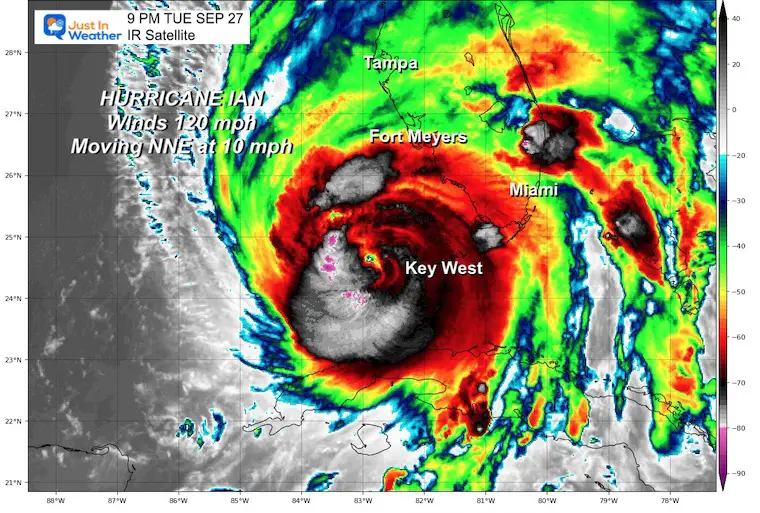
Quick Stats
- Winds are 120 mph = Category 3
- Moving to the NNE 10 mph
- Hurricane Force Winds reach 40 miles from the center.
- Tropical Storm force winds extend 140 miles from the center.
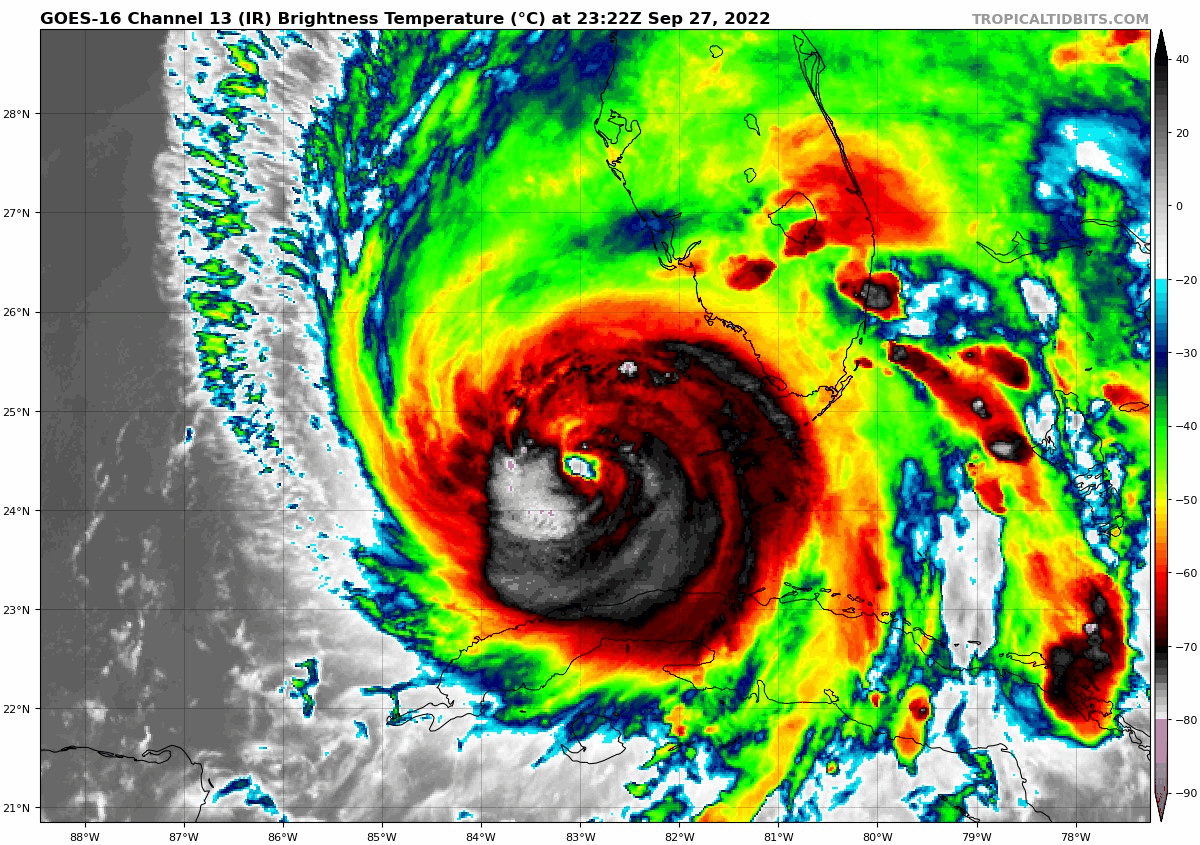
IR Satellite Loop
———————————————-
LOCATION…24.4N 83.0W
ABOUT 180 MI…290 KM SSW OF PUNTA GORDA FLORIDA
ABOUT 20 MI…35 KM SSW OF THE DRY TORTUGAS
MAXIMUM SUSTAINED WINDS…120 MPH…195 KM/H
PRESENT MOVEMENT…NNE OR 15 DEGREES AT 10 MPH…17 KM/H
MINIMUM CENTRAL PRESSURE…947 MB…27.96 INCHES
Looking Ahead to Friday
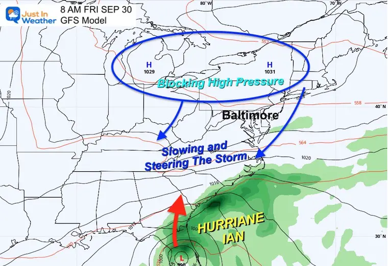
Eastern US Weather Set Up
This is a classic set up that if repeated this winter would be great for a snow and ice storm. Mark my words, we will see a storm like that this winter ahead! (atmospheric memory)
But now we focus on the remains of the hurricane.
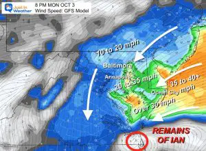
High Pressure across the Great Lakes to New England will inhibit the progress of Hurricane Ian. It will slow down the remains as the move north through Georgia or the Carolinas. This is what should force it to turn to the coast SOUTH OF MARYLAND.
The net result will be a sharp cutoff of the reach of steady and heavy rain. This is the problem with who will get wet or stay dry on Saturday. The general plan is dry north of Baltimore and turning wert to the south.
It also may allow the circulation to redevelop off of the Mid Atlantic coast, resulting in rain lingering into Tuesday or Wednesday next week. Yes, a long time ahead.
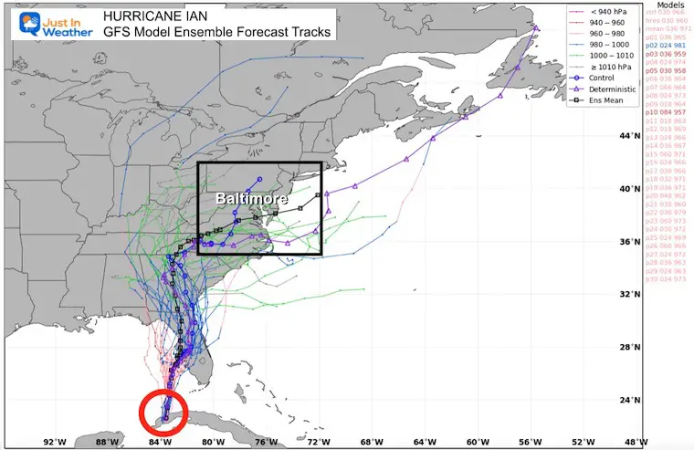
Computer Model Forecast Plots
GFS Model
These are all the ensemble members, with the consensus plot highlighted black. That tracks directly through Central Maryland including metro Baltimore.
Now let’s look at why…
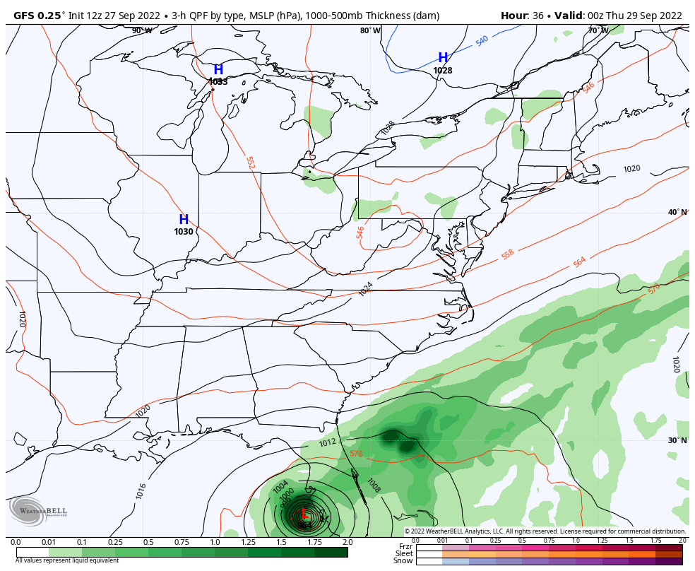
Dealing With This For A Week
Hurricane Ian Forecast Animation
GFS Model 8 PM Wed Sep 28 to 8 AM Wed Oct 5
See the local map snapshots below
This is one solution (NOT GUARANTEED). This shows the Florida track, then curve into Georgia, and redeveloping Low off of the Mid Atlantic coast next week.
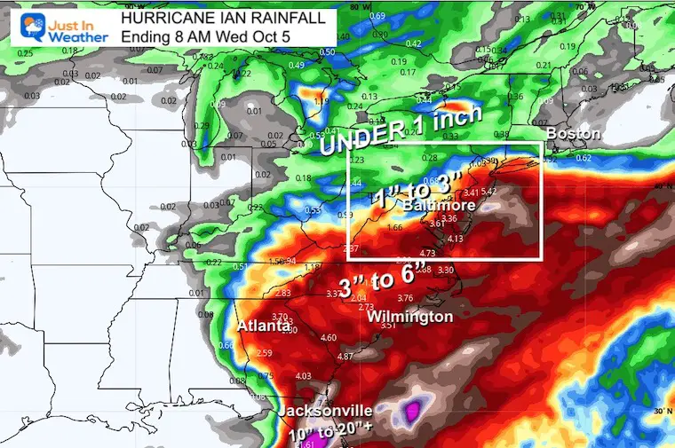
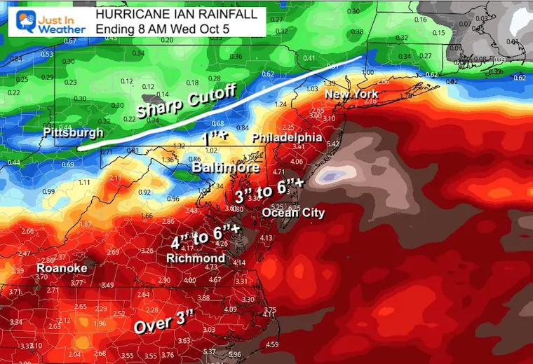
Rainfall Forecast: Eastern US
See the closer local maps below
Florida gets 10 to over 20 inches of rain.
Most of the Southeast to Delmarva get 3 to 6 inches, where flooding is possible.
Rain Snapshots
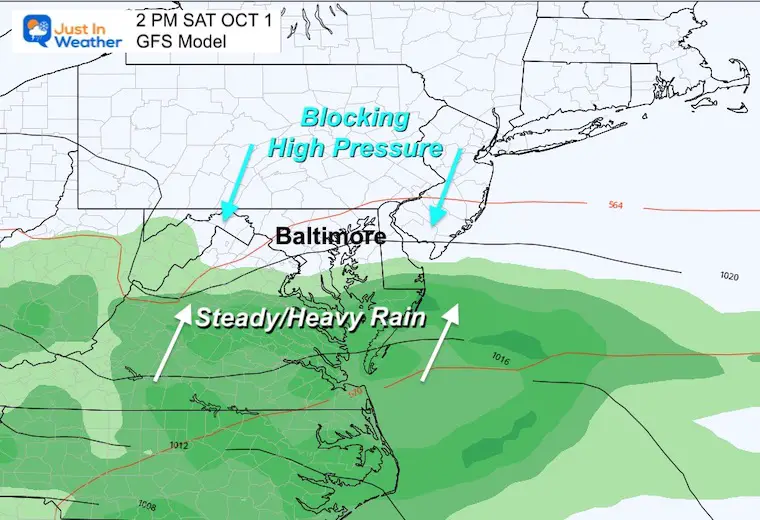
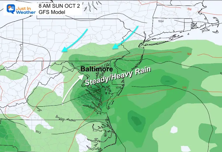
Saturday Afternoon:
With the Blocking High to the NORTH, rain will slowly be moving in from the south. Southern Maryland to Ocean City should turn wet, but it may take until evening to reach Baltimore. Farther north in PA shod stay dry.
Sunday Morning
Steady rain should envelope metro Baltimore and into southern PA and east across all of Delmarva to the beaches.
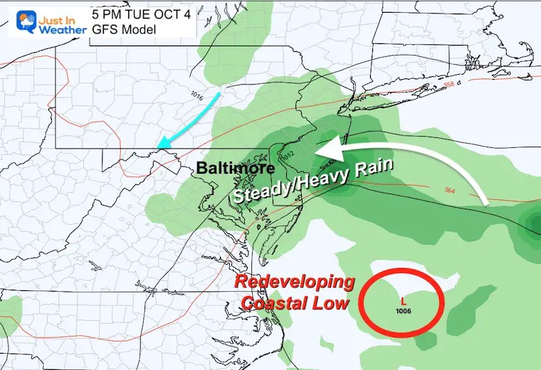
Tuesday Evening
This is when we may see the remnant Low redevelop off of the coast. If so, then rain will get tossed back inland for anther day.
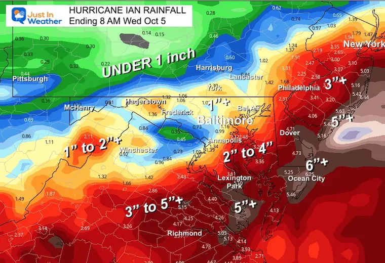
Local Rainfall Forecasts
Note that this is from the GFS Model and not the final word. This is simply a suggestion.
A sharp cutoff of the rain will be due to that High Pressure. The exact location will be subject to a few things:
- How strong the High is
- The speed of Ian
- The track of Ian may be determined by its landfall location and forward speed to the north
Local Potential Rainfall: Through Next Week With The Same System
Flooding and heavier rain is more likely to the south and east of Baltimore across Southern Maryland and the Beaches.
Metro Baltimore to Southern PA could be in for a modest 1 to 2 inches.
RADAR WIDGET
PATTERN CHANGER?
Hurricane Ian May Help Cooler Pattern Change: Monitor For Atmospheric Memory This Winter
CONNECTION TO WINTER?
If you want a snowy winter, this is what you might want to look for in the rest of the tropical season.
Record August For No Named Tropical Storms: Closer Look At Snow Following
Hurricane Season Forecast: June 1 Through November 30
NOAA 2022 Hurricane Forecast- Above Normal Again

Related Posts
NOAA Study: Reducing Air Pollution INCREASED Tropical Storms

Atlantic Tropical History: Maps of Origin Regions Every 10 Days


Please share your thoughts, best weather pics/videos, or just keep in touch via social media
STEM Assemblies/In School Fields Trips Are Back
Click to see more and ‘Book’ a visit to your school


