Conditions: Baltimore, Maryland, 04/19/2024 11:00:04 pm
Temperature

54°

Cloudy

51°

Dew Point
Relative Humidity

90%

Feels Like

54°

Wind (ESE)

6mph

Air Pressure

30.03

Sun
Sun Rise

06:22 AM

Sun Set

07:48 PM

Day Length

13:26 Hours

Difference

2 min 23 sec gain

Moon
Moon Rise

03:53 PM

Moon Set

04:38 AM

Next: Full Moon

Apr 23,2024

Moon Phase

Waxing Gibbous

Climate
Average Low

44°

66°

Average High
Record Low

24°


(1875)

93°


(1896)
Record High
Conditions

Severe Thunderstorm Watch Sunday September 25: Rain Timeline and Live Radar

NOAA
Maryland Weather
Severe Weather
Forecast
Warnings

Sunday Afternoon Update

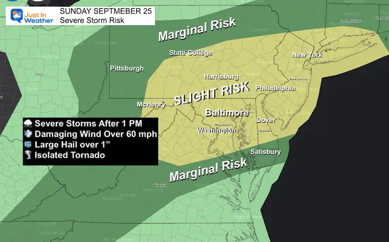
A Severe Thunderstorm Watch has been issued for most of Maryland west of the Chesapeake Bay and South Central Pennsylvania until 7 PM.  This was anticipated with the approaching cold front. Multiple rounds of storms are expected, and they will arrive at different times across the region. It is important to note that not all will see the same intensity of storms, but there is potential for high elevated alerts.

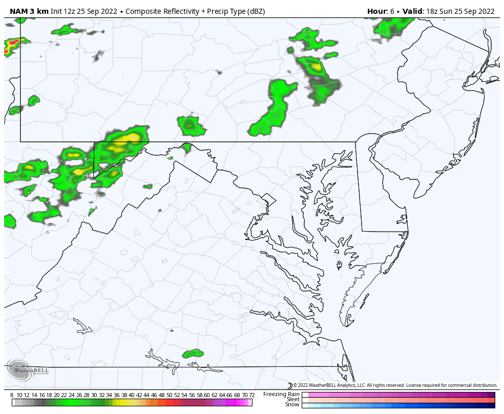
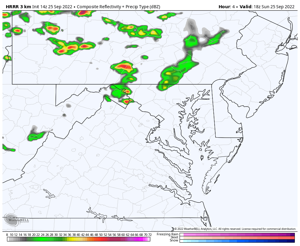
In this report is a look at two computer model simulations and the live radar to compare.

Severe Thunderstorm Watch: NOAA

This means there is potential but not a promise. We have the ingredients for storms to form and turn severe. If any cells do reach the criteria, then a Warning will be issued and that storm will be tracked through specific towns and counties. 


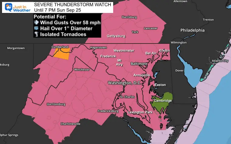
A storm is considered severe if it has:

  • Winds over 58 mph 
  • Hail over 1 inch in diameter
  • Isolated tornadoes or rotation

Any storm (even if not severe) may produce blinding downpours, flash flooding, and dangerous lightning.

NOAA Storm Outlook: NOAA

I shared this map this morning. It matches the Watch Counties. 

Radar Simulation Timeline —> slider

NAM 3 Km Model 3 PM to 11 PM

september-25-sunday-weather-storm-radar-nam-pm-3
september-25-sunday-weather-storm-radar-nam-pm-4
september-25-sunday-weather-storm-radar-nam-pm-5
september-25-sunday-weather-storm-radar-nam-pm-6
september-25-sunday-weather-storm-radar-nam-pm-7
september-25-sunday-weather-storm-radar-nam-pm-8
september-25-sunday-weather-storm-radar-nam-pm-9
september-25-sunday-weather-storm-radar-nam-pm-10
september-25-sunday-weather-storm-radar-nam-pm-11
previous arrow
next arrow

Animations (Compare Models) 

NAM 3 Km: 2 PM to Midnight

I added an extra hour before and after the slider above…

Please consider this product has recently been underplaying rain coverage and about 1 hour slower than verified. 

Sunday September 25 severe storm radar NAM

HRRR Model: 2 PM to Midnight

This model keeps some spotty showers or storms around later into the evening for central Maryland, but much less intense for Southern Maryland and Delmarva.

I think a hybrid between this and the other model solution is likely to be what will verify.

Sunday September 25 severe storm radar HRRR

LIVE  Radar and Lightning Widget

I’ve posted this in case you want to see any development.

You can control the location: pan, pull out wider, or zoom in closer.


Weather posts straight to your inbox

Sign up and be the first to know!


Tropical Storm Ian: Latest Update

Tropical Storm Ian Still Expected To Be A Major Hurricane As Track Shifts West


When Is The Typical FIRST FROST?

Average Frost And Freeze Dates in Maryland and Pennsylvania


COMPARE TO THE  PAST

If you want a snowy winter, a busy tropical season AFTER a quiet August has done it before.

Record August For No Named Tropical Storms: Closer Look At Snow Following


Related Posts


NOAA Study: Reducing Air Pollution INCREASED Tropical Storms


Atlantic Tropical History: Maps of Origin Regions Every 10 Days

13_Tropical Storm Formation Sep11_20


In Case You Missed It: Seem Early Winter Outlooks

Winter Outlook 2023 La Niña Triple Dip Expectations

Winter Outlook 2023 Early Look At Snow From Two Farmers Almanacs


Please share your thoughts, best weather pics/videos, or just keep in touch via social media