


April 24 Weather: Some Showers Then Another Push Of Cold Air Followed By Summer Heat Sunday
Wednesday, April 24 Morning Report A milder start today with most areas in the 50s to near 60ºF along parts of the Bay. There is a push of colder air…
August 16 2022
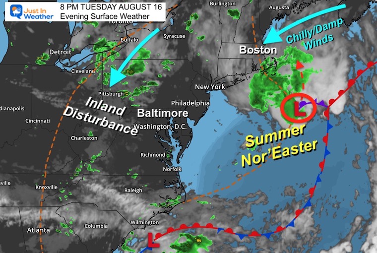
Tuesday Evening Update
As we enter the second half of August, we should be talking about the tropics heating up. But as of today, there is no activity in the Atlantic. If this holds, then we could have the first August with no hurricanes since 2013.
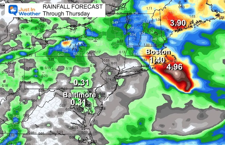
Instead, we are talking about a Nor’easter for New England. It’s not a major storm, but definitely a beach disruption which will try to have the typical wider spread impact across the region. A landfall north of Boston, but wrap around showers will try to drop south into Maryland Wednesday evening.
Here is the developing Low Pressure taking form southeast of Boston. This storm is occurring, cutting off from the upper level flow, which will allow it to drift back northwest into Maine Wednesday night into Thursday morning.
Also See: Tuesday Evening The Last 8 PM Sunset Of The Year
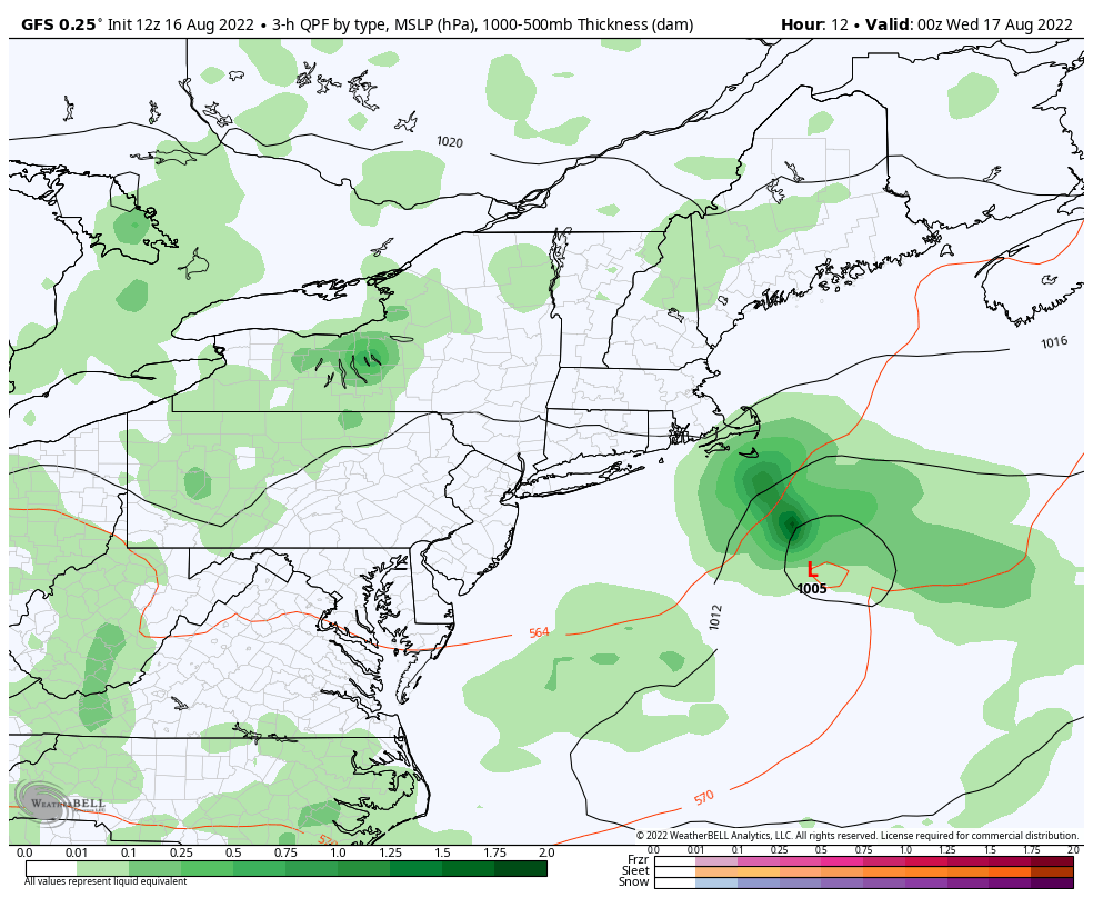
GFS Model 8 PM Tuesday to 8 AM Thursday
This looks like a landfall near Bangor, Maine on Thursday morning.
8 AM Wednesday to 8 AM Thursday
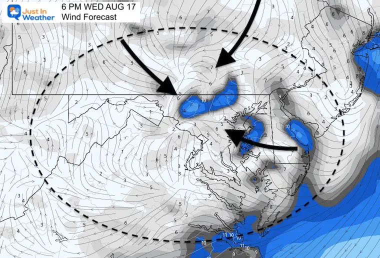
The wind machine will be tightly wrapped around the Low across Long Island to coastal New England.
Some brisk winds along the Delmarva beaches may be 10 to 20 mph from the Northeast. This will stir up rip currents from Rehoboth to Ocean City.
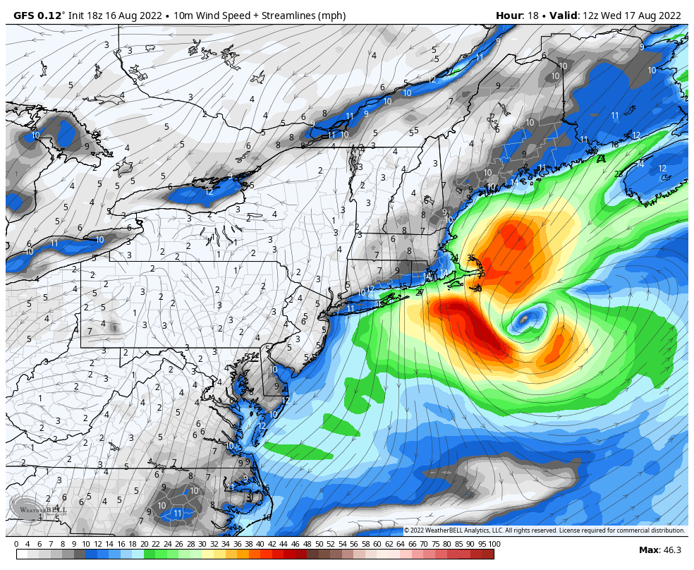
8 PM Here the GFS shows Low Pressure east of Boston and Cape Cod. The wrap around winds will drop a shield of rain with temps in the 50s. That is far from late summer weather.
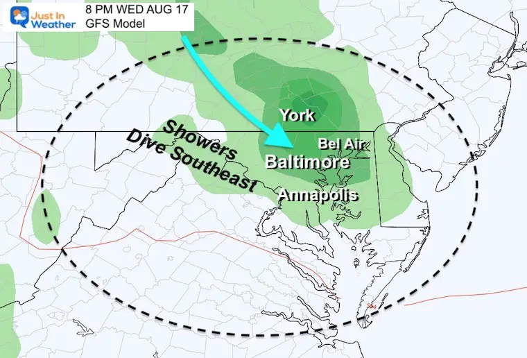
The larger upper level winds will bring a disturbance across south center Pennsylvania and north central Maryland.
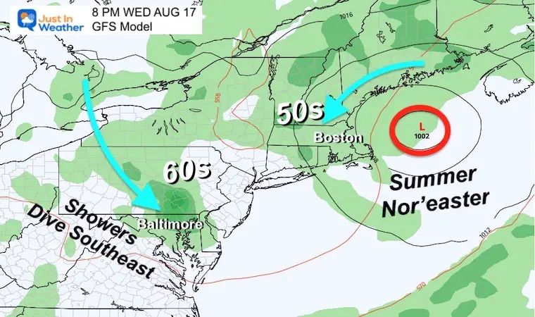
A band of rain will try to form and spread across York to metro Baltimore.
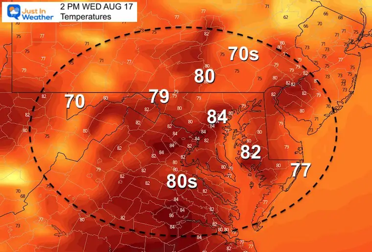
Afternoon temps should reach the upper 70s to lower 80s in the afternoon. But that does depend on the cloud cover and if the timing follows our recent trend and arrive earlier than the models show.
Temps will drop with the clouds and rain from the north… Then a chilly hint of fall may return to the air.
The disturbance we expect will be marked by a wind boundary.
This is likely to be a mid afternoon to early evening event. Under normal circumstances, this might just be presumed to be cooling late day showers.
However, I wanted to show how this is connected to the bigger story of the coastal storm in New England.
We will watch for increasing clouds and a band of rain or even thunderstorms FROM THE NORTH any time after 2 PM into the evening.
This will end at night and much less influence on Thursday should return nicer weather for a couple of days.
Those that get rain locally will be around 1/4 to 1/2 inch.
The real event will be eastern New England. Between Cape Cod and coastal Maine there may be 2 to over 4 inches of rain with the little Nor’ester.
I will have a more detailed timeline in my Wednesday morning update. See you then.
The team, support crew, and YOU!
Thank you! We have raised OVER $112,600 (so far). We still have more to add in, and will continue to accept donations into our final total until Sunday.
You may notice a video player at the top of this page. I put all of our individual daily recap reels in there, just in case you wanted to see them. One final recap will be ready shortly.
By Popular Demand and Supporting Just In Power Kids
This is the shirt that Power Kid James and his family has embraced… They even surprised us with this sign during our Kids Trek Too event.
It is now available!

Click the image or here for more info

NOAA 2022 Hurricane Forecast- Above Normal Again


NOAA Study: Reducing Air Pollution INCREASED Tropical Storms

Atlantic Tropical History: Maps of Origin Regions Every 10 Days


May 16 Large Hail Videos And Storm Tracking Map


*Disclaimer due to frequent questions:
I am aware there are some spelling and grammar typos. I have made a few public statements over the years, but if you are new here you may have missed it:
I have dyslexia, and found out at my second year at Cornell. It didn’t stop me from getting my meteorology degree, and being first to get the AMS CBM in the Baltimore/Washington region.
I do miss mistakes in my own proofreading. The autocorrect spell check on my computer sometimes does an injustice to make it worse.
All of the maps and information are accurate. The ‘wordy’ stuff can get sticky.
There is no editor that can check my work when I need it and have it ready to send out in a newsworthy timeline.
I accept this and perhaps proves what you read is really from me…
It’s part of my charm.