


April 19 Showers Later Today Then Strong Winds Usher In Colder Air Tomorrow
Friday April 19 Morning Report The pattern is about to change. The sunny and mild days we have had will be replaced with a colder-than-average outlook into next week. This…
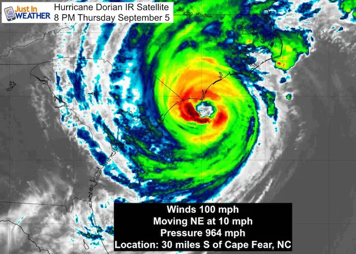
Thursday Evening September 5 2019
Hurricane Dorian is still looking impressive on satellite tonight with it’s closet approach to the US coast. The eye has 100 mph winds and is passing within 30 miles of Cape Fear, SC. The eye is expected to make landfall in North Carolina early Friday morning, then head back out into the Atlantic.
Hurricane Dorian IR Satellite
Tropical Storm Warnings have been issued for southern Maryland. Tornado Watches have been issued just south in Virginia. But how far north will the rain reach? That is what is shown in the first slider below, and it could get to Baltimore. It may feel like a Nor’easter in central Maryland with gusty winds, but on the edge of light rain showers. The real feel of the storm will be in St. Mary’s to Salisbury and Ocean City.
See the wind and waves forecast maps below as well.
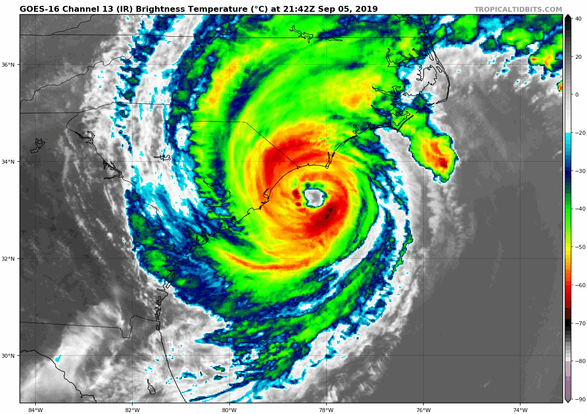
Hurricane Dorian IR Satellite Loop
Forecast Maps
European ECMWF Model
Morning– The edge of the rain on the north ends will try to reach Baltimore and I-95 up to Philadelphia. The heaviest rain will be south of Ocean City around Virginia Beach to OBX.
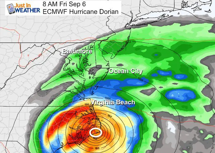
Afternoon – The interaction of our old front and the edge of Dorian will try to keep a band of rain around I-95. The bulk of the rain (according to this model) will be just offshore of Ocean City. 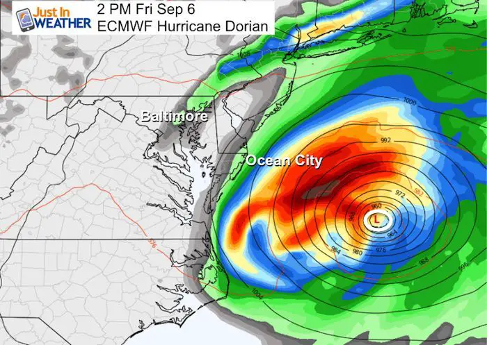
NAM 3 KM —> slider
Hourly forecast maps show a higher resolution. The rain around Baltimore may spotty, but should be light.
Ocean City should have its heaviest rain between 9 AM and 4 PM. This is shown to be more than the European Model above.

Tropical Storm and Hurricane Warnings
Tropical Storm Conditions expected in Maryland include: Ocean City, Salisbury, Cambridge, and St. Mary’s City.
Weather Risks:
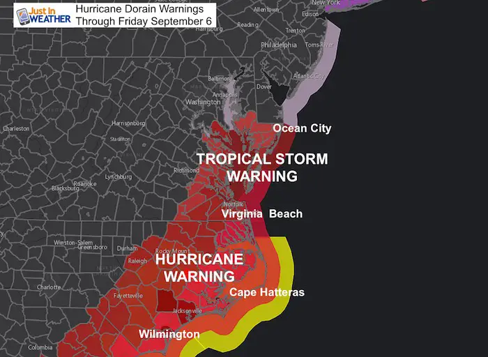
A Storm Surge Warning is in effect for...
* Cape Fear to Poquoson VA
* Pamlico and Albemarle Sounds
* Neuse and Pamlico Rivers
* Hampton Roads

A Hurricane Warning is in effect for...
* South Santee River to the North Carolina/Virginia border
* Pamlico and Albemarle Sounds

A Tropical Storm Warning is in effect for...
* North Carolina/Virginia border to Fenwick Island DE
* Chesapeake Bay from Drum Point southward
* Tidal Potomac south of Cobb Island
* Woods Hole to Sagamore Beach MA
* Nantucket and Martha's Vineyard MA
Wind Forecast Maps
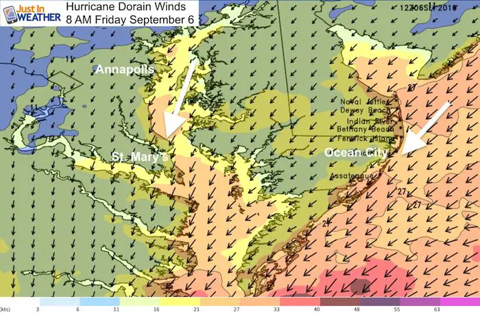
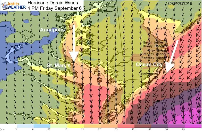
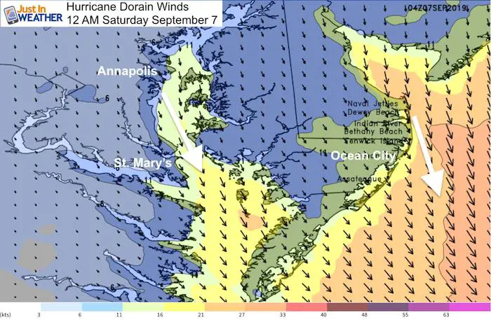
Tracking Hurricane Dorian with the strongest local winds on Friday. Watch the direction change as it passes by.
Coastal Wind Forecast –> slider

Local Wind Forecast –> slider

Chesapeake Bay Wind Forecast
Friday morning: The wind direction from the Northeast. This what will slosh water to the western and southwestern part of the Bay. If there is some Bay flooding, this would be the time.
Speed on the Bay 15 to 25 mph with gusts over 30 mph
Ocean City winds from the Northeast 25 mph and higher
Friday Afternoon: Winds shift from the north. This will help drain water out of the Bay, but along the way water will be high in St. Mary’s County towards Norfolk.
Wind speed 20 to 35 mph with higher gusts
Ocean City winds from the Northeast 30 to 40 mph and higher
Midnight: Winds from the Northwest and high lighter on the Bay. Coastal winds will shift offshore and ease as well
Waves Forecast —> slider

Find tides for your location on the Bay: Click here
Also see: Atmospheric Memory Of Hurricanes Over Thousands Of Years Shaped The Coas
Just in case you don’t get all posts on your social media feed, stay up to date with the latest info…
Click here to sign up for email alerts…. Be the first to hear any new weather
Thank you to our Title Sponsor for Maryland Trek 6
Shining on with Smyth and their contribution, our team has raised over $95,000 for Just In Power Kids to provide free programs for kids in and post cancer treatment.

Please share your thoughts, best weather pics/video, or just keep in touch via social media
Maryland Trek Cycle Jerseys From Hill Killer
All proceeds will go to the Maryland Trek 6 total and Just In Power Kids programs

Just In Power Kids:
Proceeds go to our programs Providing FREE holistic care for kids in cancer treatment and up to 5 years post treatment and caregivers.
![]()
Shine On
Proceeds from all sales go to Just In Power Kids. Click the image to shop and show your support.

Love Maryland Shirts and Hoodies
This shirt was designed by my ‘bonus’ daughter Jaiden. The hoodie has been the biggest hit, so our promotion has been extended until the end of this week.
|
||
|
Show your love for Maryland and make this 14 year old artist and her mom extra proud
|
Related Links:
Was Your County Not Included?
Click this map for more on the regional forecast zones
