


April 16 Stepping Back From Summer Heat To A Cool And Wet Pattern
Tuesday, April 16 Morning Report Yesterday was sincerely a summer preview! Temperatures did soar as expected into the mid-80s with BWI hitting the mark of 85ºF. This fell short of…
Monday July 22 2019
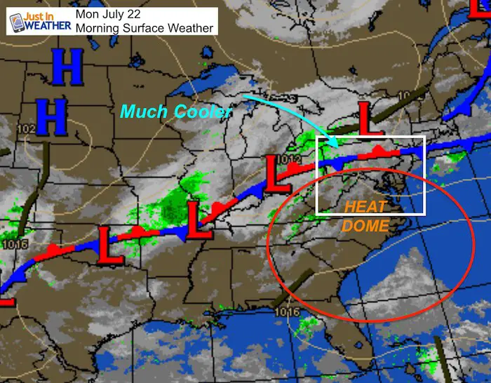
Why if I told you that the high temperature tomorrow may be cooler than this morning’s lows? To break a heat wave like this, often we must deal with powerful storms. Parts of Maryland and PA had then Sunday, but more get in on the action today.
Today will be the last hot day of this stretch as storms develop any time after 2 PM. Multiple storms are likely through the afternoon and evening. A Flash Flood Watch is in effect for the risk of severe storms and excessive rainfall. See the radar simulation below.
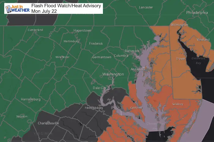
Flash Flood Watch
All counties shaded in green have the potential for flooding in multiple storms. The orange shaded counties on Delmarva and southern Maryland still have a Heat Advisory as storms will arrive later allowing them to heat up more today.
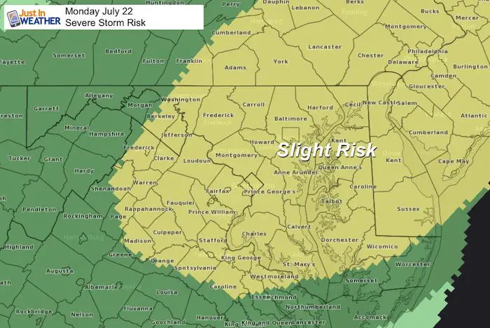
Risk For Severe Storms
This means storms with winds over 60 mph, large hail, and isolated tornadoes. This product can be deceiving. I believe we can consider today as a moderate risk.
Average High: 87ºF
Record High: 106ºF in 2011
Average Low: 67ºF
Record Low: 53ºF in 1966
Sunrise: 5:57 AM
Sunset 8:27 PM
*Daylight = 1:35 shorter than yesterday
*Bay Water Temperature = 86ºF at Thomas Pt. Light House
Just in case you don’t get all posts on your social media feed, stay up to date with the latest info…
Click here to sign up for email alerts…. Be the first to hear any new weather
Morning Weather
Afternoon and Evening Storms
Radar Simulaiton —> slider

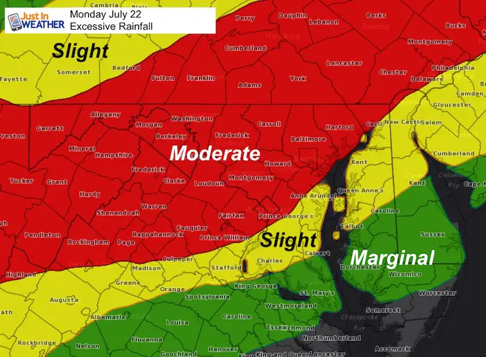
Excessive Rainfall
The heaviest of the rain is likely in central and western Maryland to southern Pennsylvania. Some storms may produce over 2 inches of rainfall in a short period of time.
There is so much moisture in the humid air that heavy rainfall and quick flooding is possible in any of multiple storms.
Temperatures About To Drop!
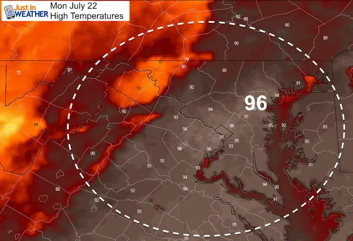
Monday Afternoon
Still hot, but starting to cool down. The 70s showing up between Hagerstown and northern Frederick County are just a blip in the modeling. This region will be warmer, but see multiple storms today.
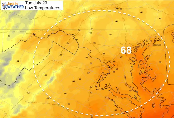
Tuesday Morning
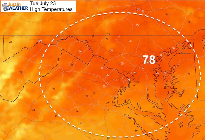
Tuesday Afternoon
For many this will be cooler than Monday morning
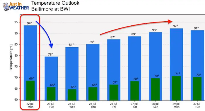
Temperature Outlook
Big drop tomorrow and feeling great for the rest of the week. But more heat will return by the end of the weekend and next week.
Please share your thoughts, best weather pics/video, or just keep in touch via social media
Bring Your Kids To Join My Team: Maryland Trek 6
Kids Trek Too!
Bring Your Kids To Join My Team This Summer
Click the logo for more information
![]()

Support Our Nonprofit:
Proceeds go to our programs Providing FREE holistic care for kids in cancer treatment and up to 5 years post treatment and caregivers.
![]()
Shine On
Proceeds from all sales go to Just In Power Kids. Click the image to shop and show your support.

Love Maryland Shirts and Hoodies
This shirt was designed by my ‘bonus’ daughter Jaiden. The hoodie has been the biggest hit, so our promotion has been extended until the end of this week.
|
||
|
Show your love for Maryland and make this 14 year old artist and her mom extra proud
|
Related Links:
Was Your County Not Included?
Click this map for more on the regional forecast zones
