March 11 2022
Friday Afternoon Update
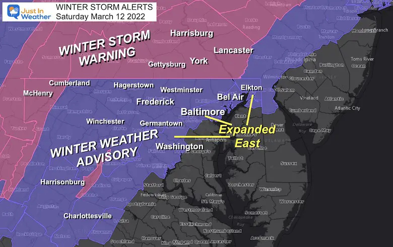
This may end up being the strongest storm of our winter season, regardless of what ends up being measured on the ground. The expectation of a faster change over to snow Saturday morning has pressed the issue that the impact will reach more into metro areas. The Winter Weather Advisory has been expanded east to include Metro Baltimore, the northern Chesapeake Bay, and Metro Washington DC.
If you read my prior report with the snow maps, then this was expected. I have NEW snow maps from NWS and all have increased snow expectations.
Winter Storm Warning and Winter Weather Advisory:
Quick Reference:
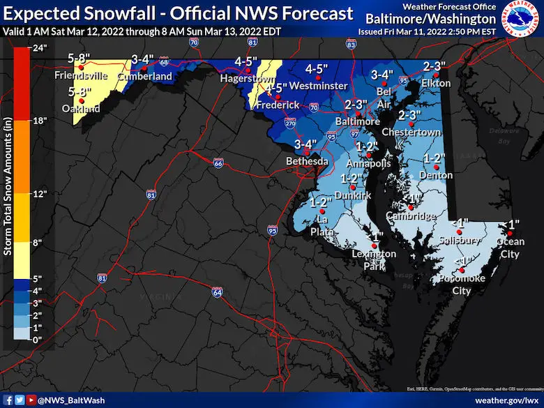
- Winter Storm Warning (pink): Snow 4 to 8 inches
- Winter Weather Advisory (purple): Snow 2 to 4 inches
- If your area is NOT colored in, there may be less stickage, but you still get in on falling snow/wind/and icing potential Saturday evening.
The snow maps from 4 computer models AND NWS are below. I am sorry I am tied up with a prior obligation with my wife, so please forgive me if I do not make a personal snow map. I will try this evening if I can get a break in time.
FITF
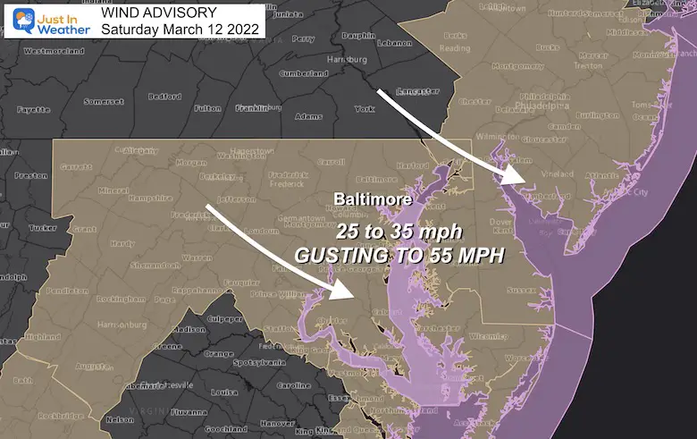
Wind Advisory:
Winds will average 25 to 35 mph. Gusts can max out up to 55 mph!
This is the power that will crash temps in the morning and allow the rapid change to heavy snow and flash freeze.
Please note that the winds will NOT stop at the PA line. I believe NWS State College will join in on the party, so expect the same wind conditions across Adams, York, and Lancaster Counties.
What’s Making This Special?
Let’s disregard the wins and losses from earlier this season. Yes, we can consider that the ground is warm, and the sun angle is high now in mid March. What is working in the favor of winter will be:
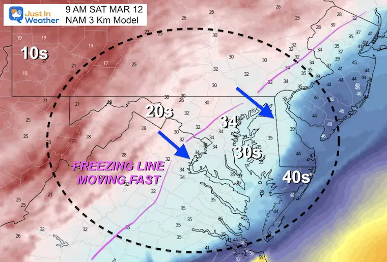
- Rapid Drop Of Temps to FREEZING between 8 AM and 10 AM for the metro areas… Not long after to Southern Maryland and Delmarva.
- Snow will continue to fall at a moderate to heavy pace for a few hours. 1″ per hour rate can overtake the warmer ground.
- Temps will drop into the 20s during the afternoon. A flash freeze on pavement is possible.
- By evening, most of the region will be in the 20s. So what was went should ice up before the wind has a chance to dry it out.
- Sunday morning will remain in the teens and 20s. Due to the Time Change, we lose an hour which means more activities may be affected if there is ice.
EXPLORE MORE:
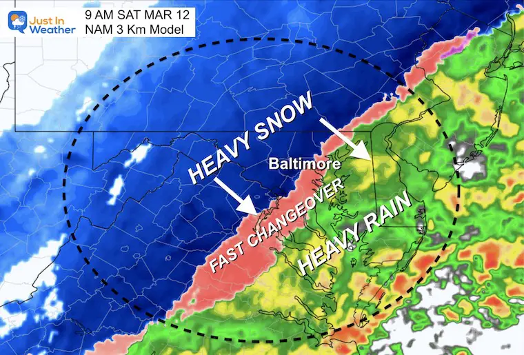
How Much Snow May Fall?
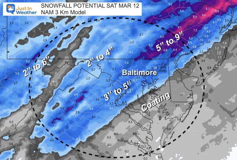
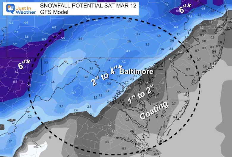
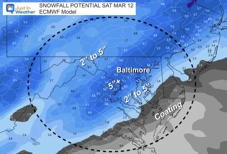
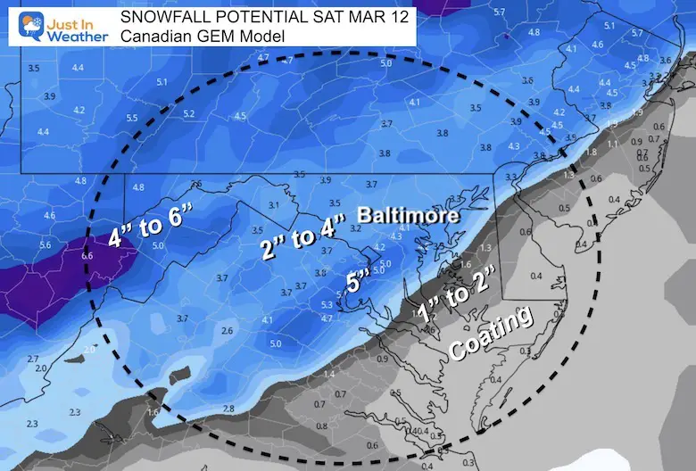
Here is a simply a look at four computer models and the National Weather Service maps for Maryland and Pennsylvania. These include the Exploited Snow, High End, and Low End potential.
These amounts are for what will fall, but we must consider that some will melt.
As for shoveling and plowing I would apply a general rule:
1/2 of the totals on the maps for what may lay and stay on pavement to be pushed/shoveled.
Computer Model Forecasts
NAM 3 Km
GFS Model (lowest snowfall for central MD)
Europea Model
Canadian GEM
National Weather Service Snow Maps
THESE ARE NEW*HIGHER* TOTALS
REMINDER:
As for shoveling and plowing I would apply a general rule:
1/2 of the totals on the maps for what may lay and stay on pavement to be pushed.
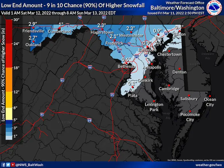
Maryland: Expected, High AND Low End
Click To See:
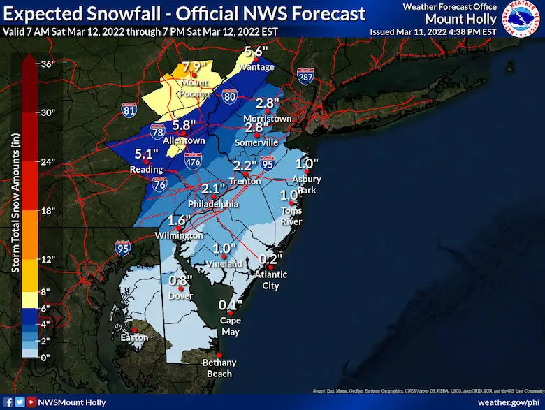
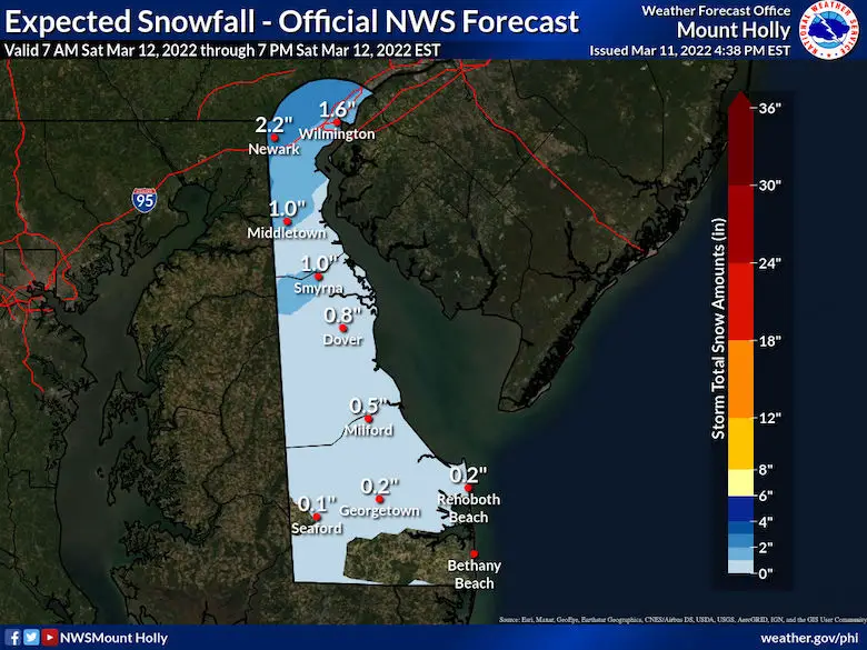
Expected
High Potential
Lowest Potential
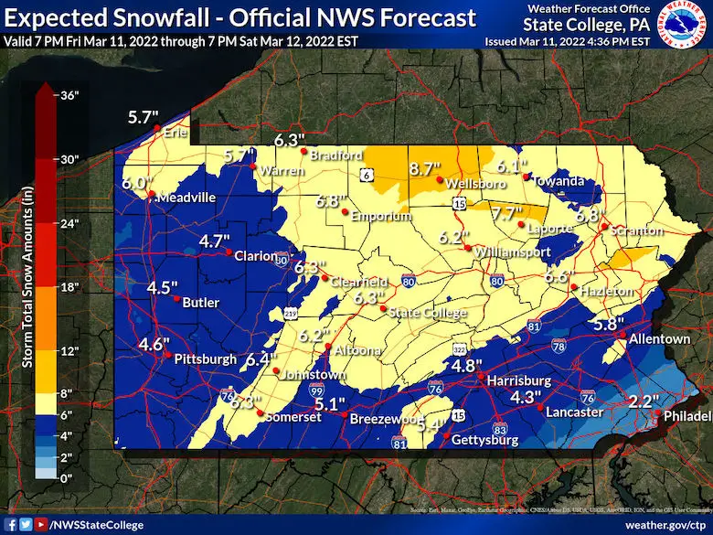
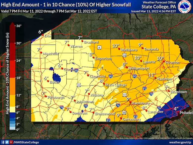
Pennsylvania : Expected, High AND Low End
Expected
Highest Potential
Lowest Potential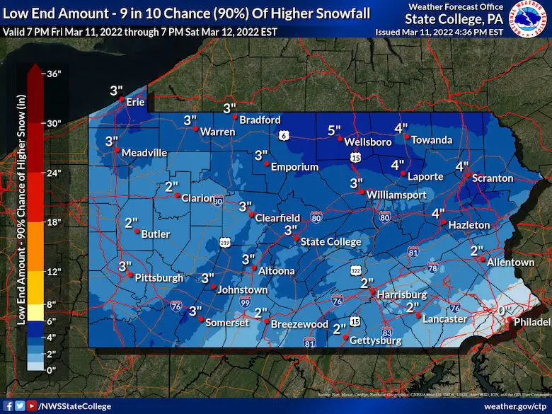
New Jersey
Delaware
I will follow up with any new Advisories and snow info later..
Faith in the Flakes.
ALSO SEE
ALL FITF GEAR

FITF THUNDERSNOW


Winter Outlook Series:
My Call For Snowfall

Last Winter Recap: My Old Outlook And Your Grades Of My Storm Forecasts


Please share your thoughts, best weather pics/video, or just keep in touch via social media
*Disclaimer due to frequent questions:
I am aware there are some spelling and grammar typos. I have made a few public statements over the years, but if you are new here you may have missed it:
I have dyslexia, and found out at my second year at Cornell. I didn’t stop me from getting my meteorology degree, and being first to get the AMS CBM in the Baltimore/Washington region.
I do miss my mistakes in my own proofreading. The autocorrect spell check on my computer sometimes does an injustice to make it worse.
All of the maps and information are accurate. The ‘wordy’ stuff can get sticky.
There is no editor that can check my work when I need it and have it ready to send out in a newsworthy timeline.
I accept this and perhaps proves what you read is really from me…
It’s part of my charm.
#FITF


