Sunday, April 7 2024
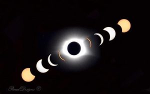
The total solar eclipse across the United States on Monday, April 8, is now one day away. This major celestial event will cross the path of millions and is expected to be more profound than the 2017 eclipse. The reason is that the moon will be closer, thus making for a larger shadow and longer-lasting event.
It is important to note that this is all or nothing for the full effect! The path of Totality, or 100% coverage of the sun by the moon, is where the sky will turn dark, and you can briefly view it with your naked eye. Places with 99% or less on the edge of the shadow will experience less profound results. Places with less than 90% coverage may not notice much difference than those seeing 50% coverage.
This is why it is such a big deal for both your location and a clear sky! I have covered this in a prior report here:
2024 SOLAR ECLIPSE INFO: Compare to 2017 Event
I am one of millions of people who have traveled to view this event and now have anxiety about cloud cover. This report will be a tremendous resource for all eclipse chasers who might make a last-minute adjustment to travel into another zone for a better chance of fewer clouds. It will also show the risk for severe weather across parts of the path of totality.
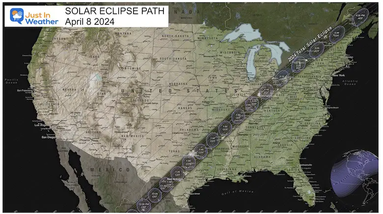
Total Solar Eclipse Path Map
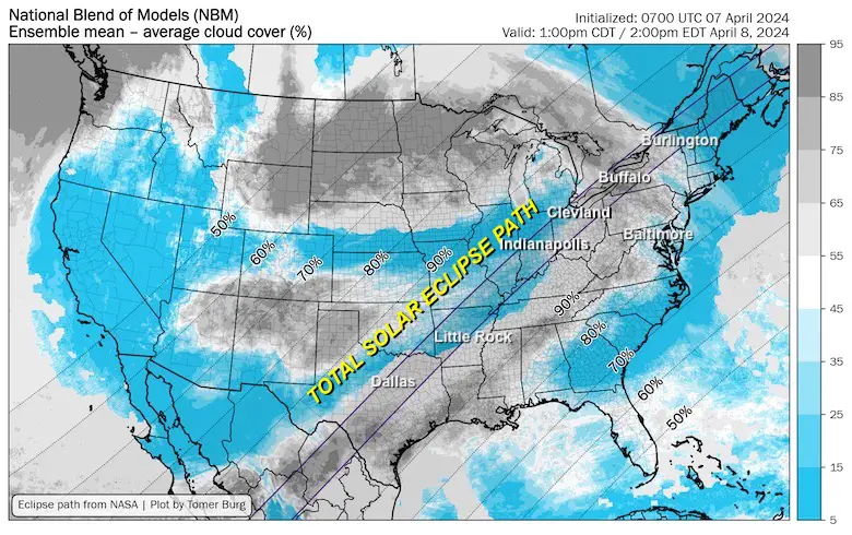
Forecast Cloud Cover: USA
These maps were prepared by Meteorologist Tomer Burg. More on him and his excellent resources below. There are closer maps and more details to follow.
Total Cloud Cover: National Blend of Models
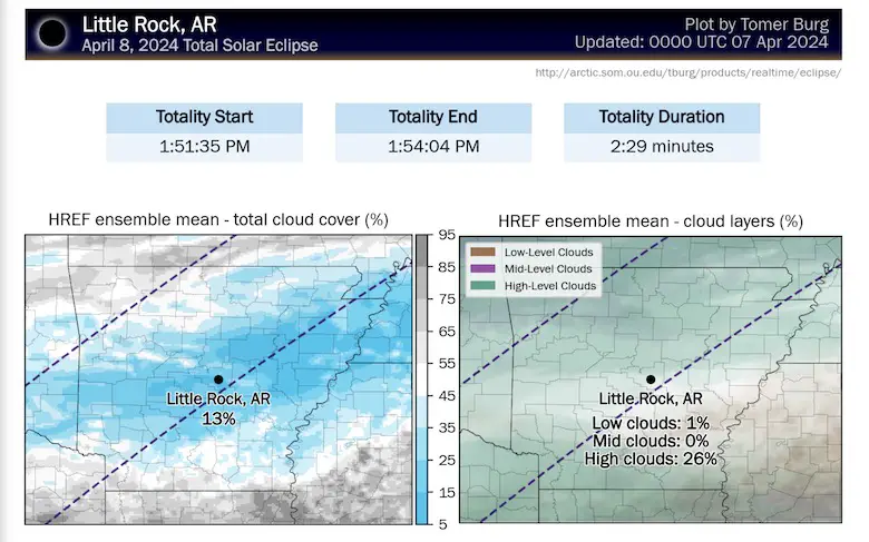
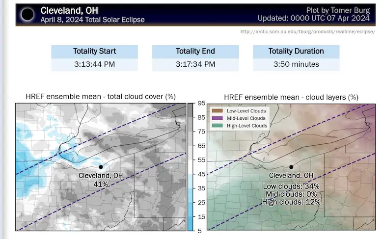
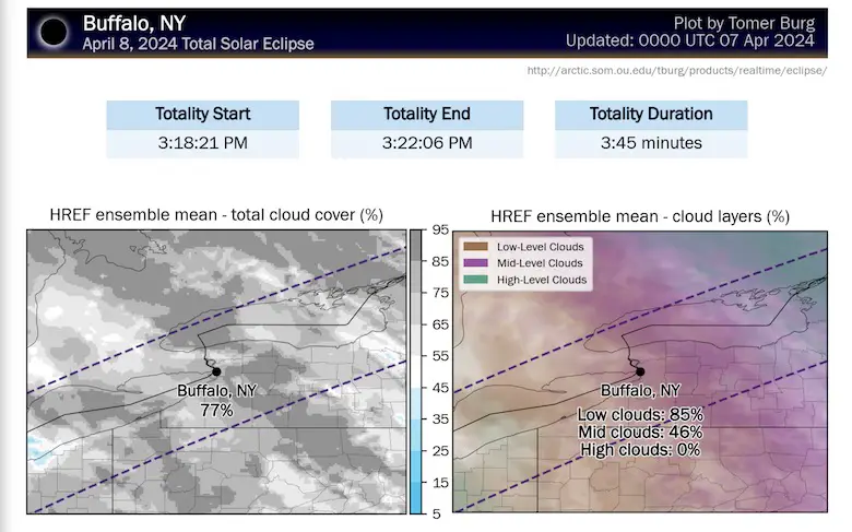
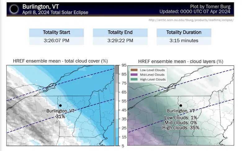
This simply shows any clouds. It does not designate low clouds that are more opaque vs. high thin cirrus that may be more transparent.
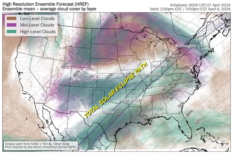
Cloud Cover By Layer: High-Resolution Forecast
This does better designate the expectation of cloud layers. High clouds can be thin and transparent or opaque.
Lower clouds (usually the puffy and darker ones) can range on the coverage.
Difficulty: A partly cloudy sky can still have clouds blocking the sun for your location, OR a mostly cloudy sky can have breaks to view the sun at your location. This can range widely just a few miles apart.
I Played The Odds On The South End
Personally, I traveled to Dallas to view the total eclipse. The climate data showed more likelihood for less clouds here than the Great Lakes or New England in early April. Plus, my son loves this city and wanted to watch baseball at Globe Life Stadium before we met up with the rest of our crew.
It has been a lot of coordination to do this and reserve a vehicle. This is also what allows us to make a game-time decision to travel once again…
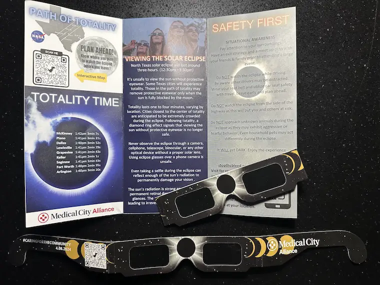
Eclipse Guide And Glasses
This was handed out at the Texas Rangers game last night. Thank you, Medical City Alliance.
The link from this QR code is to the NASA Solar Eclipse Page
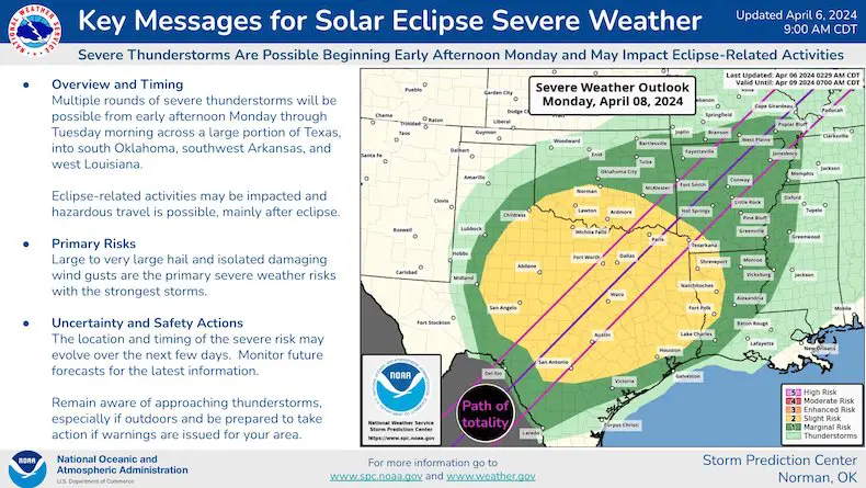
I Came To Texas To Chase An Eclipse, NOT Severe Storms
NOAA has put out a severe storm risk map for this region. The storm forecast is for later in the day and evening into Tuesday. This is important for all the people traveling who will be on the roads after the event and even flying back to their home cities afterwards.
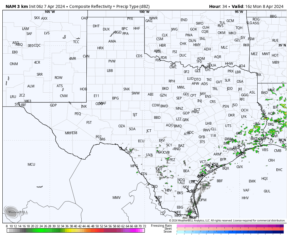
Texas Radar Simulation: NAM 3 Km Model
Monday at Noon to Tuesday at 8 AM
City Forecast Map Sampler
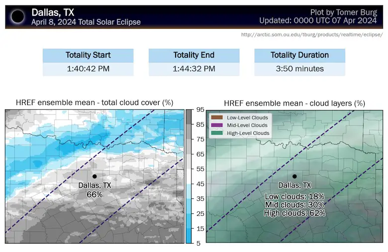
This is from the City Dashboard on Tomer Burg’s page. A link to track on your own is below.
Dallas, TX
This is the reason we may consider a drive 4 to 8 hours away.
Little Rock, Arkansas
Cleveland, OH
Buffalo, NY/ Niagara Falls Region
Burlington, VT
EXCELLENT Eclipse Forecast Map Resources
Major Credit to Tomer Burg, Ph.D. student at The University of Oklahoma and undergraduate from SUNY Albany.
Resource Pages
Eclipse Forecast Cloud Maps
http://arctic.som.ou.edu/tburg/products/realtime/eclipse/
Interactive City Dashboard
This is very useful. Use the small map in the upper left corner to pan, zoom, and click on your choice of city details in that location
http://arctic.som.ou.edu/tburg/products/realtime/eclipse/
STEM Assemblies/In School Fields Trips Are Back
Click to see more and ‘Book’ a visit to your school

Please share your thoughts and best weather pics/videos, or just keep in touch via social media
RESTATING MY MESSAGE ABOUT DYSLEXIA
I am aware there are some spelling and grammar typos and occasional other glitches. I take responsibility for my mistakes and even the computer glitches I may miss. I have made a few public statements over the years, but if you are new here, you may have missed it: I have dyslexia and found out during my second year at Cornell University. It didn’t stop me from getting my meteorology degree and being the first to get the AMS CBM in the Baltimore/Washington region.
One of my professors told me that I had made it that far without knowing and to not let it be a crutch going forward. That was Mark Wysocki, and he was absolutely correct! I do miss my mistakes in my own proofreading. The autocorrect spell check on my computer sometimes does an injustice to make it worse. I also can make mistakes in forecasting. No one is perfect at predicting the future. All of the maps and information are accurate. The ‘wordy’ stuff can get sticky.
There has been no editor who can check my work while writing and to have it ready to send out in a newsworthy timeline. Barbara Werner is a member of the web team that helps me maintain this site. She has taken it upon herself to edit typos when she is available. That could be AFTER you read this. I accept this and perhaps proves what you read is really from me… It’s part of my charm. #FITF
Recent Snow Reports
Click each map for the maps and snow spotter lists.
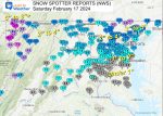
February 17 Snow Report Maps
February 13 Snow Report Maps
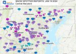
January 19 Recap
Click here for the maps and full report
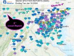
Jan 16 Snow Report
Click here or the map to see: The Snow Report Ending Jan 16
Subscribe for eMail Alerts
Explore More
Maryland Snow Climate History And Other Winter Pages


