


April 19 Showers Later Today Then Strong Winds Usher In Colder Air Tomorrow
Friday April 19 Morning Report The pattern is about to change. The sunny and mild days we have had will be replaced with a colder-than-average outlook into next week. This…
July 8, 2023
Saturday Night Update
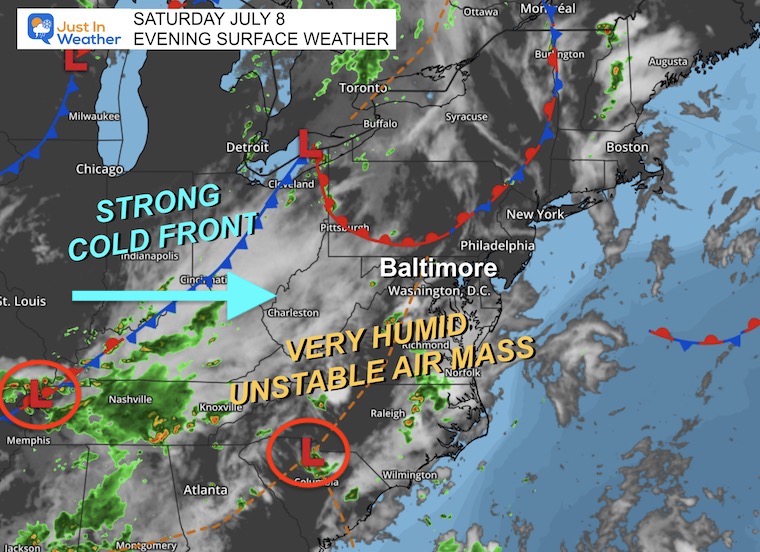
The unstable atmosphere in place is easy to identify if you go outside. It is a warm and muggy night, which seems like typical summer. We had a flare-up of strong thunderstorms from Southern Maryland earlier to metro Baltimore and along I-95 into the early evening.
Sunday will bring the instigator of a strong cold front plus a few ripples of Low Pressure. In short, there will be more widespread thunderstorms, and the very humid air plus slow-moving or multiple storm cells may produce very heavy rain.
This is a brief report to help you plan, but I will have a full update in the morning that may be more specific. I did include the live radar widget just in case you view this report on Sunday.
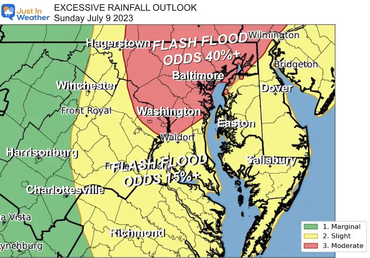
NOAA’s Storm Prediction Center has issued a Moderate Risk (in red) for our region on Sunday. This includes Washington, Baltimore, York, and central Pennsylvania where a GREATER THAN 40% Chance for Flash Flood Warnings will be issued.
The potential is for local storms that can easily drop 1 to 3 inches of rain in a hurry. But as we have seen in the past week, some storms can drop over 5 inches of rainfall enhancing the risk for flash flooding.
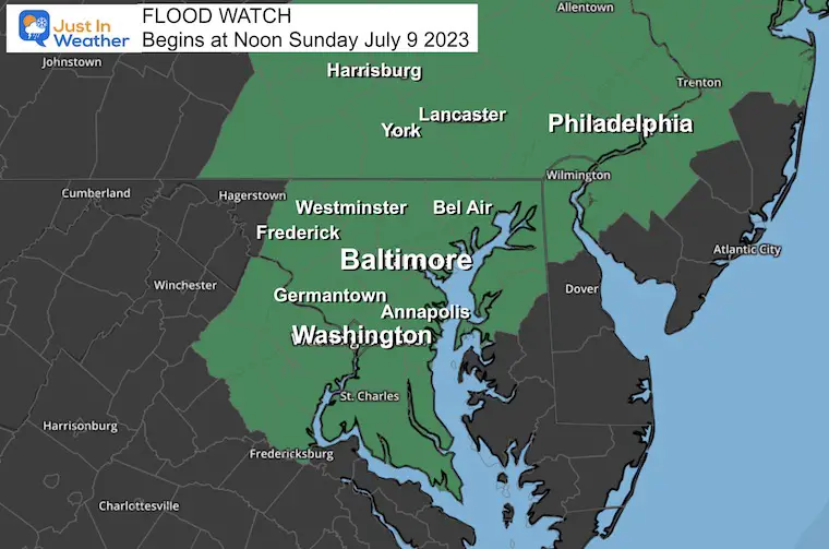
Flash Flood Watch
Sunday Beginning at 12 PM
Slow moving and or multiple storms may produce 1 to 3+ inches of rain.
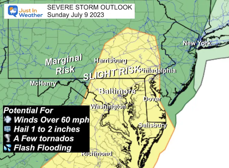
We do have a Slight Risk for storms to turn severe. While there is a chance some storms may produce damaging wind, large hail, and a few tornadoes… I still think the main threat is for heavy rainfall and flash flooding.
With a broad area of humid air, the dew points are in the 70s.
Overnight into Sunday there are a few ripples of Low Pressure and the cold front that will help to lift the air with the afternoon heat and lead to our storm outbreak.
This will get more active on Sunday. Compare to the forecast maps below.
Shortly after sunrise, we may see some storm cells pop in central Maryland. This shows the suggestion they may be around the Baltimore Beltway.
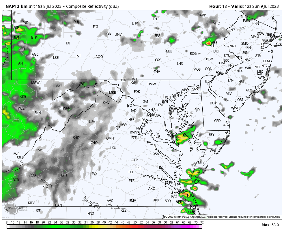
I would prepare for rain and thunderstorm at anytime after 8 AM. The most intense will be between Noon and 6 PM
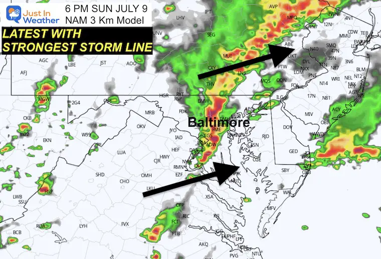
This model is suggesting the LATEST time for the strong line of storms to cross central areas.
This suggestion shows the flare-up of storms near I-95 in central Maryland and into south central PA.
This suggestion by that same model shows more storms and widespread rain. The slow moving locally heavy storm cells may not all be picked up here… but there could be a few hours of dumping rain.
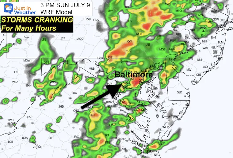
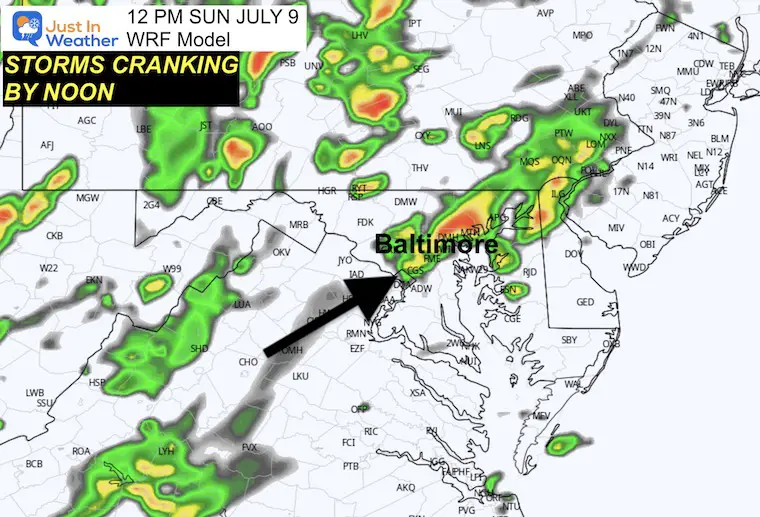
This model also suggests that the peak of activity reaches central areas within 60 to 100 miles of Baltimore mid-afternoon. This is 3 hours EARLIER than the NAM 3 Km Model shown above.
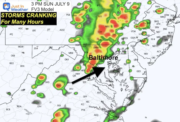
Plan for storms any time during the day, but the heaviest may be between Noon and 6 PM.

I am aware there are some spelling and grammar typos and occasional other glitches. I take responsibility for my mistakes, and even the computer glitches I may miss. I have made a few public statements over the years, but if you are new here you may have missed it: I have dyslexia, and found out during my second year at Cornell University. It didn’t stop me from getting my meteorology degree, and being the first to get the AMS CBM in the Baltimore/Washington region. One of my professors told me that I had made it that far without knowing, and to not let it be a crutch going forward. That was Mark Wysocki and he was absolutely correct! I do miss my mistakes in my own proofreading. The autocorrect spell check on my computer sometimes does an injustice to make it worse. I also can make mistakes in forecasting. No one is perfect predicting the future. All of the maps and information are accurate. The ‘wordy’ stuff can get sticky. There has been no editor that can check my work when I needed it and have it ready to send out in a newsworthy timeline. Barbara Werner is a member of the web team that helps me maintain this site. She has taken it upon herself to edit typos, when she is able. That could be AFTER you read this. I accept this and perhaps proves what you read is really from me… It’s part of my charm.
#FITF