Conditions: Baltimore, Maryland, 04/16/2024 03:10:03 am
Temperature

63°

Mostly Clear

36°

Dew Point
Relative Humidity

36%

Feels Like

63°

Wind (NNE)

7mph

Air Pressure

30.07

Sun
Sun Rise

06:27 AM

Sun Set

07:45 PM

Day Length

13:18 Hours

Difference

2 min 25 sec gain

Moon
Moon Rise

12:49 PM

Moon Set

03:18 AM

Next: Full Moon

Apr 23,2024

Moon Phase

First Quarter

Climate
Average Low

43°

65°

Average High
Record Low

30°


(1962)

90°


(2012)
Record High
Conditions

Rain And Storm Timeline Thursday October 13

Maryland Weather
rain timeline
tornado
Severe Weather
Forecast
video

Wednesday Evening Update

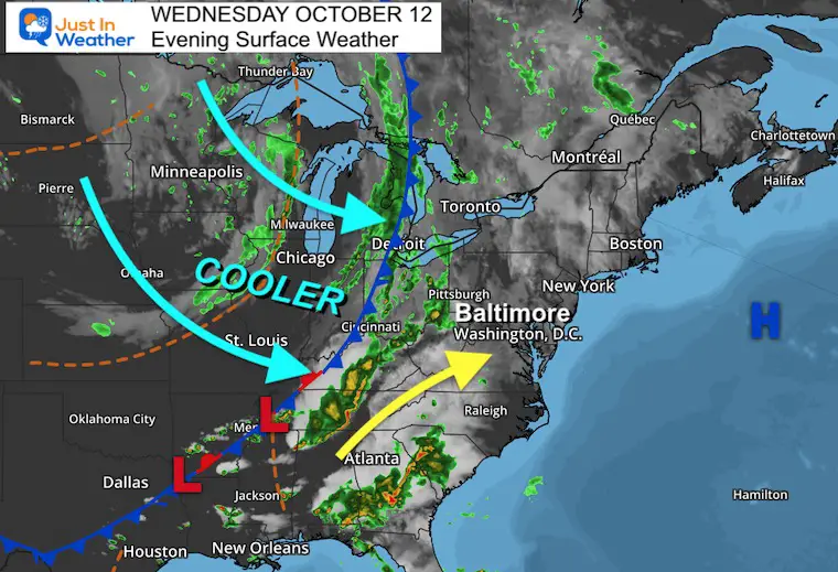
A strong cold front is moving through the nation and will reach the east coast Thursday evening.  We expect rain by morning and strong storms in the afternoon and evening across Maryland and The Mid Atlantic. A small chance some of those storms may turn severe. This may include dangerous lightning, damaging winds, small hail, and a low risk for an isolated tornado.

Below is a quick look at the set up and simulation timeline for Thursday.

Let’s back up a moment: This system has erupted several severe storm outbreaks across the central US and Upper Midwest with Wisconsin front and center. This video was captured in the Big Bend/Vernon areas.

Non-Tornado Squall Video 


Wednesday Evening Surface Weather

The cold front stretches through Detroit, Cincinnati, and Memphis. Strong storms were still active in the mountains of Tennessee and Kentucky. It will be that energy ahead of the front on Thursday that we are concerned with in the Mid Atlantic. 


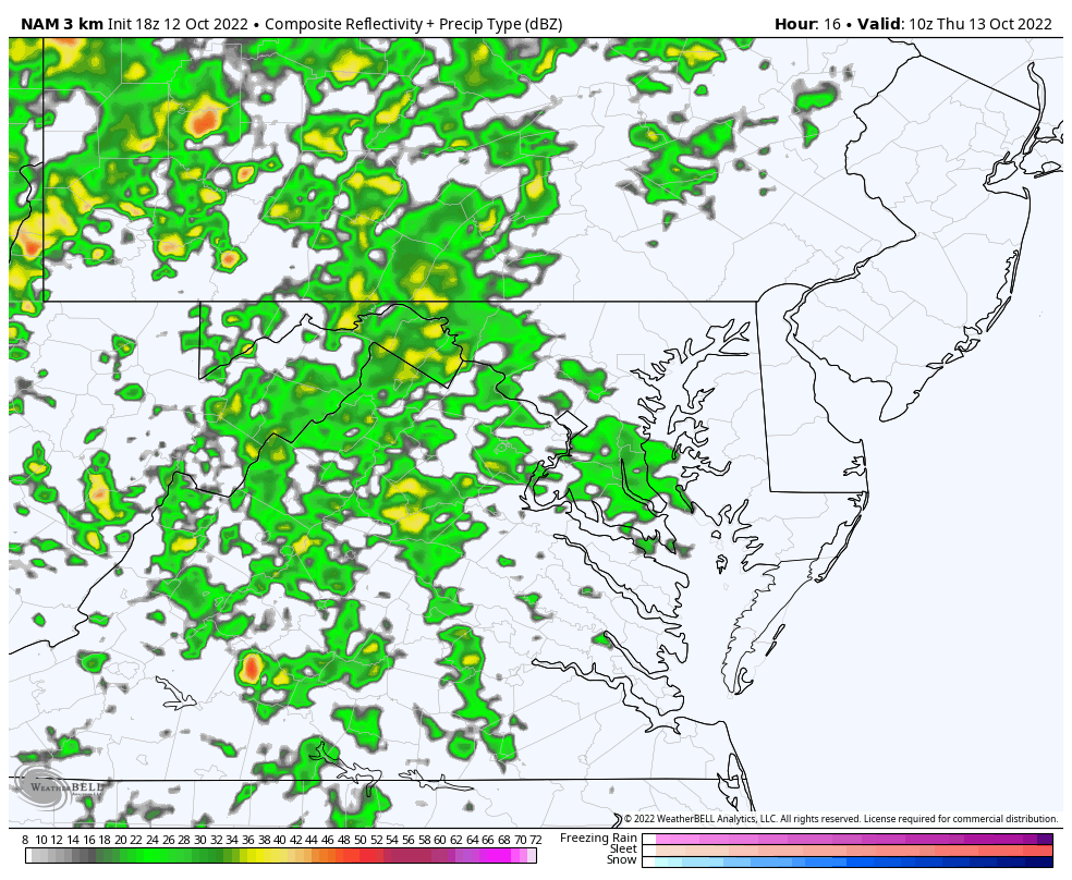
Radar Simulation Thursday 

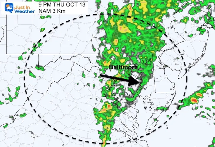
NAM 3 Km Model: 6 AM to 10 PM

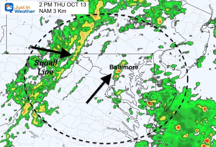
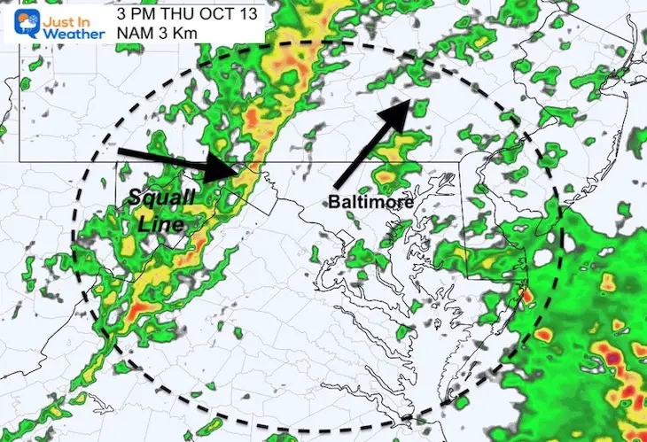
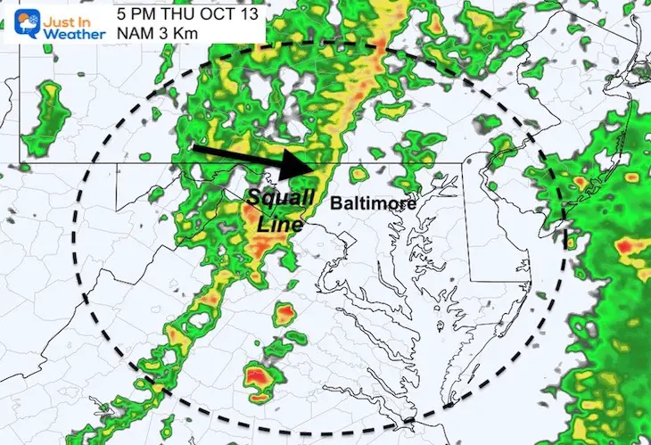
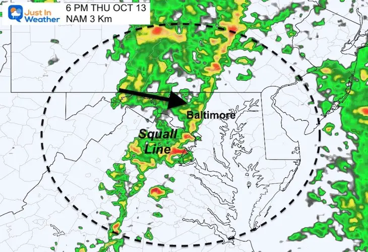
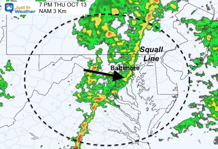
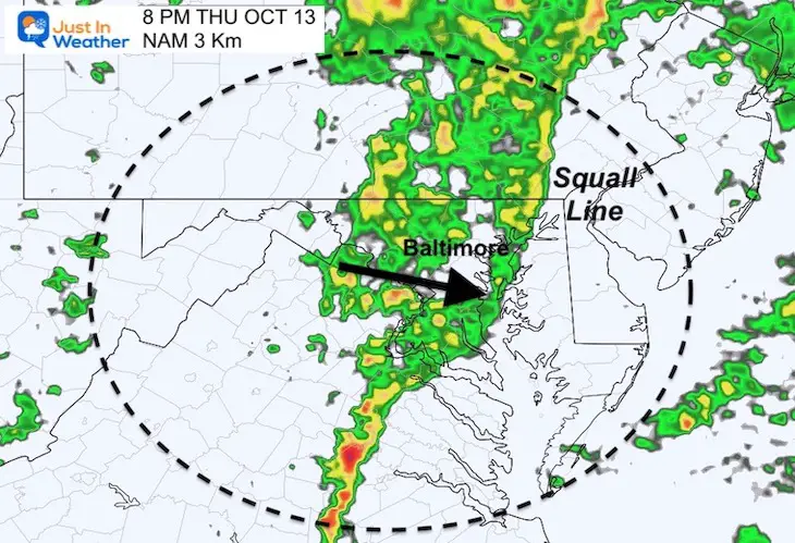
A squall line will develop in the afternoon… This where the severe storm risk lies.

October 12 forecast storm radar Thursday afternoon


Timeline Slider —-> 2 PM to 9 PM

Tracking the Squall Line.  This product has routinely been an hour or two slow.  So we my adjust the expectation in the morning report.

This squall line may contain the risk for severe storm cells.


october-13-weather-radar-storm-thursday-pm-2
october-13-weather-radar-storm-thursday-pm-3
october-13-weather-radar-storm-thursday-pm-4
october-13-weather-radar-storm-thursday-pm-5
october-13-weather-radar-storm-thursday-pm-6
october-13-weather-radar-storm-thursday-pm-7
october-13-weather-radar-storm-thursday-pm-8
october-13-weather-radar-storm-thursday-pm-9
previous arrow
next arrow
Please check back in the morning. I will have a full report with new timeline and forecast posted around 6 AM

Weather posts straight to your inbox

Sign up and be the first to know!

EXPLORE MORE: WHEN IS THE FIRST FROST?

Average Frost And Freeze Dates in Maryland and Pennsylvania


STEM Assemblies/In School Fields Trips Are Back

Click to see more and ‘Book’ a visit to your school

Please share your thoughts, best weather pics/videos, or just keep in touch via social media


PATTERN CHANGER?

Hurricane Ian May Help Cooler Pattern Change: Monitor For Atmospheric Memory This Winter

CONNECTION TO WINTER?

If you want a snowy winter, this is what you might want to look for in the rest of the tropical season.

Record August For No Named Tropical Storms: Closer Look At Snow Following


Hurricane Season Forecast: June 1 Through November 30

NOAA 2022 Hurricane Forecast- Above Normal Again


Related Posts


NOAA Study: Reducing Air Pollution INCREASED Tropical Storms


Atlantic Tropical History: Maps of Origin Regions Every 10 Days

13_Tropical Storm Formation Sep11_20