Conditions: Baltimore, Maryland, 04/25/2024 05:20:03 am
Temperature

53°

Cloudy

43°

Dew Point
Relative Humidity

68%

Feels Like

53°

Wind (N)

7mph

Air Pressure

30.19

Sun
Sun Rise

06:14 AM

Sun Set

07:54 PM

Day Length

13:40 Hours

Difference

2 min 18 sec gain

Moon
Moon Rise

10:02 PM

Moon Set

06:52 AM

Next: Last Quarter

May 01,2024

Moon Phase

Waning Gibbous

Climate
Average Low

46°

68°

Average High
Record Low

30°


(1956)

94°


(1960)
Record High
Conditions

Freezing Rain Details: Expanded Winter Weather Advisory

Winter Weather
Warnings

Tuesday Evening Update

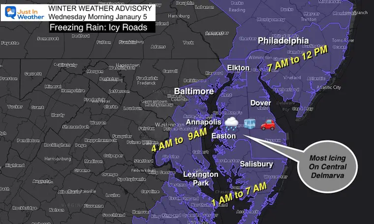
All of Delmarva is now included in the Winter Weather Advisory, with the exception of the beaches. This event will hit interior Delaware and Maryland’s Eastern Shore the hardest.  But in general most of the places that had heavy snow east of I-95 get in on something in the morning.

There are three things I want to highlight in this report: 

  1. Temperatures are already well below freezing! There is sufficient time in the dark hours for the pavement to get very cold.
  2. Even if there is some warming at cloud level or near the surface, the ground itself  will remain cold long enough for rain to freeze on contact.
  3. The back edge of freezing drizzle may be within a few miles of I-95.  That region will get light precipitation/drizzle that might not show on radar, but be enough for a glaze for form. That can be dangerous because it can catch drivers without notice. 

Winter Weather Advisory

This is the updated map, and the temps below will explain why the southern areas are involved.  

This is a time it is safe to say if the decision has not been made yet, schools in Southern Maryland and Delmarva will at least be delayed (or more ) again.


Evening Temperature Observations

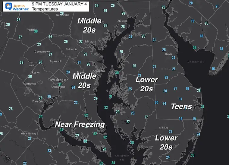
A clear sky and snowpack has allowed temps to tank!

Check out the pocket  of lower 20s and teens for some from central Delaware to Salisbury.

Annapolis and Baltimore are in the Middle 20s, with temps near freezing in souther Maryland.


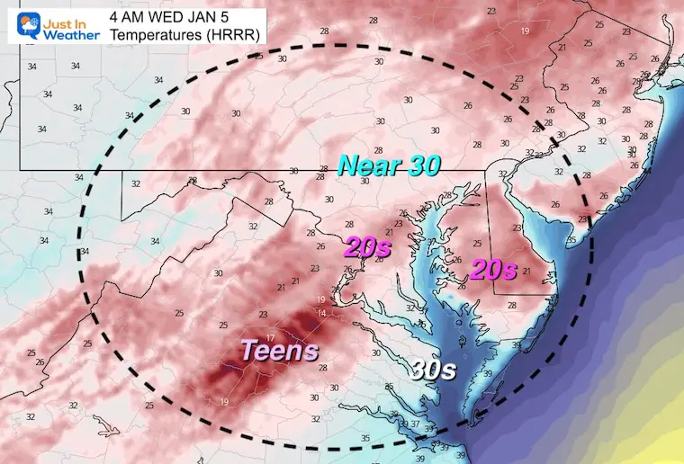
While clouds will fill in and temps may bump up a little overnight, there has been plenty of dark hours to allow the pavement to get very cold.


Temperatures Forecast 

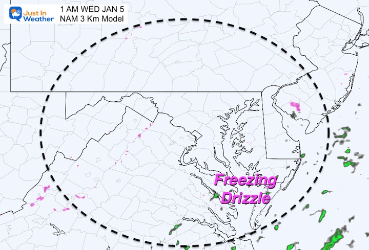
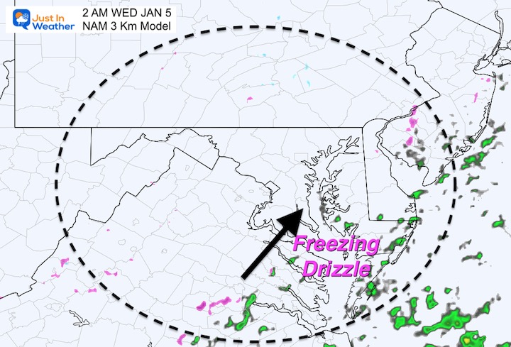
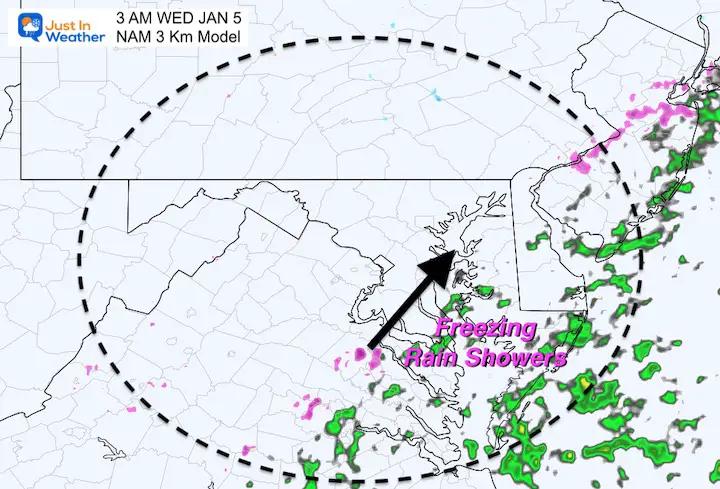
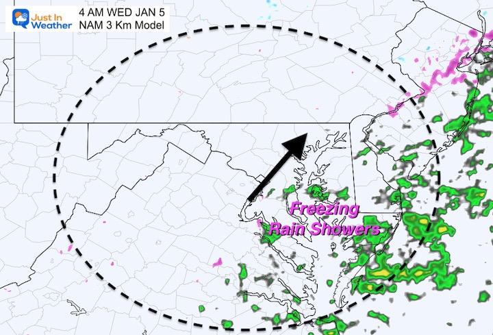
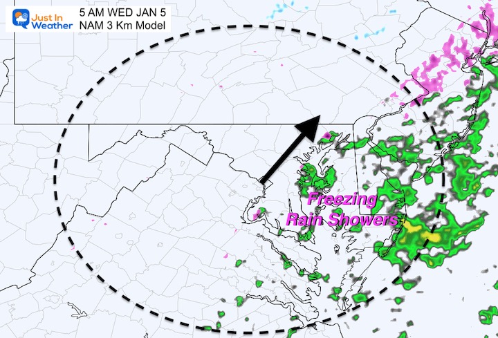
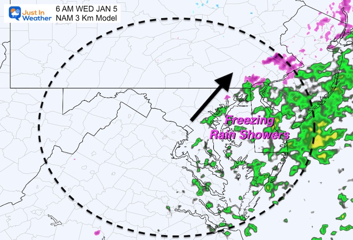
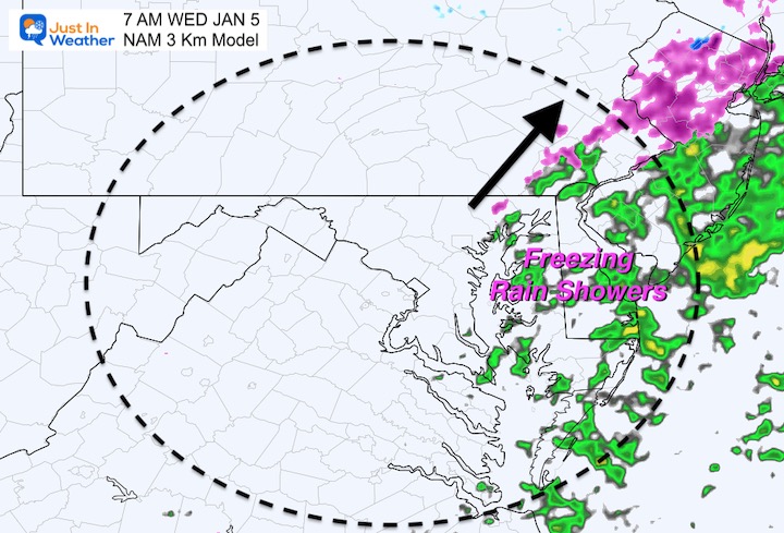
4 AM- When the precipitation should be arriving.

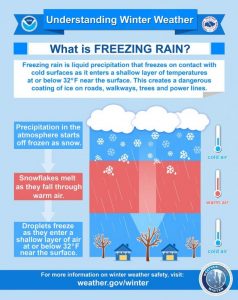
Even if there is a rise to or above 32ºF, the ground will remain cold to support rain freezing on contact. Also, if ice already forms it will take a while for that to thaw.


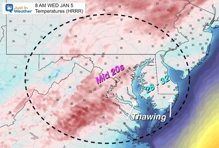
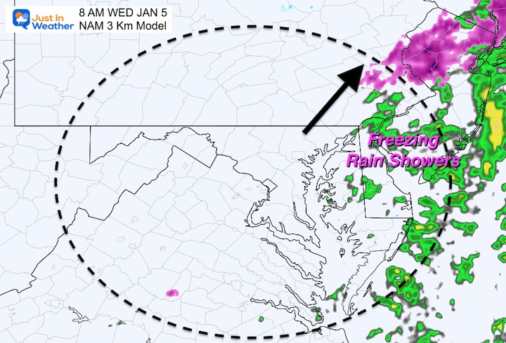
8 AM – After Sunrise and when a thaw will try to develop.

Models often try to warm up faster than can occur if there is snow or ice on the ground. So it will likely be a few more hours to thaw. 


Freezing Rain and Drizzle 

It is important to note that the models  DO NOT tend to perform well with light precipitation. So this product can be deceiving. That is why I want to show a few plots for contrast. 


Canadian GEM Model 

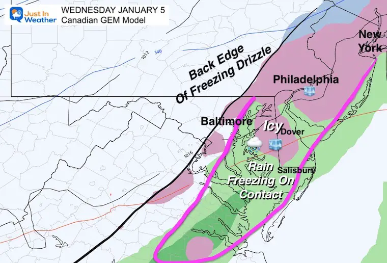
This covers the entire event.  Simply a suggestion for the impact region:

I’ve included the back edge for the ‘Freezing Drizzle’ near Baltimore and Washington. That will be spotty, but anything light can catch drivers off guard. 

Chances will increase near Annapolis then to the south.

The Eastern Shore and Delmarva will be in the main target for this event.


Radar Simulation —-> slider 

HRRR Model- Simply a suggestion and will not show all that falls. Doppler Radar may miss some falling ‘stuff’ in the morning as well.

* The deception is that it is showing rain falling (green) but discounting that the ground will still be cold enough for it to freeze.


january-4-weather-freezing-rain-nam-wednesday-am-1
january-4-weather-freezing-rain-nam-wednesday-am-2
january-4-weather-freezing-rain-nam-wednesday-am-3
january-4-weather-freezing-rain-nam-wednesday-am-4
january-4-weather-freezing-rain-nam-wednesday-am-5
january-4-weather-freezing-rain-nam-wednesday-am-6
january-4-weather-freezing-rain-nam-wednesday-am-7
january-4-weather-freezing-rain-nam-wednesday-am-8
previous arrow
next arrow

REMINDER

This will be a light event, especially on the west/Baltimore side of the Bay. 

With ice just a little bit can cause a big problem. That is what I want to make sure you pay attention. 


What Is Freezing Rain (and other winter precipitation types)?

I’ve got a whole page for that. Click the image to Explore More


Weather posts straight to your inbox

Sign up and be the first to know!


NEW ITEM: FITF THUNDERSNOW SHIRTS

ALSO SEE


What is Faith in the Flakes: History of December 5th Snow


ALL FITF GEAR


Winter Outlook Series:

My Call For Snowfall


Last Winter Recap: My Old Outlook And Your Grades Of My Storm Forecasts

Winter Weather Page – Lots of resources


Solar Cycle Increasing Sunspots Suggests More Snow


Comparing 4 Different Farmer’s Almanacs: Majority colder winter outlook than NOAA


NOAA Winter Outlook- But Read The Fine Print


Signals For Early Start To Winter In November


Winter Outlook Series: La Nina Double Dip


Nor’easters May Give Hint For Winter La Nina Pattern


Winter Folklore Checklist


Please share your thoughts, best weather pics/video, or just keep in touch via social media

Facebook: Justin Berk, Meteorologist

Twitter: @JustinWeather

Instagram: justinweather