The large winter storm is slowly moving in our direction. The emphasis now is on ‘slowly’.The ice and snow have reached northwest Pennsylvania, and that is the direction where our cold air is coming from. But putting the arrival time of the freezing line within an hour or two of sunrise will make or break the ice part of this forecast.
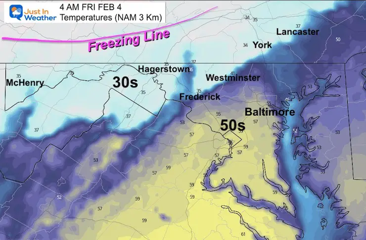
The morning models have trended to slow down the arrival time.The GFS Model may be losing its credibility. While it was first to call this ice event, it has been the coldest and fastest with the icing.This morning the high resolution NAM 3 Km model has put on the brakes long enough make me question if the ice will be an issue in our northern zones.
I just want to open the door to possibly adjusting the morning ice zones. I am not changing it yet. However, I will have an update late and may pull the plug for some. Also be aware some of the Advisories could get dropped or pushed back later. There still is the risk of icing for more at the end of the day.
*Garrett County will definitely get in on Friday morning ice!
Noon Set Up
Surface Weather
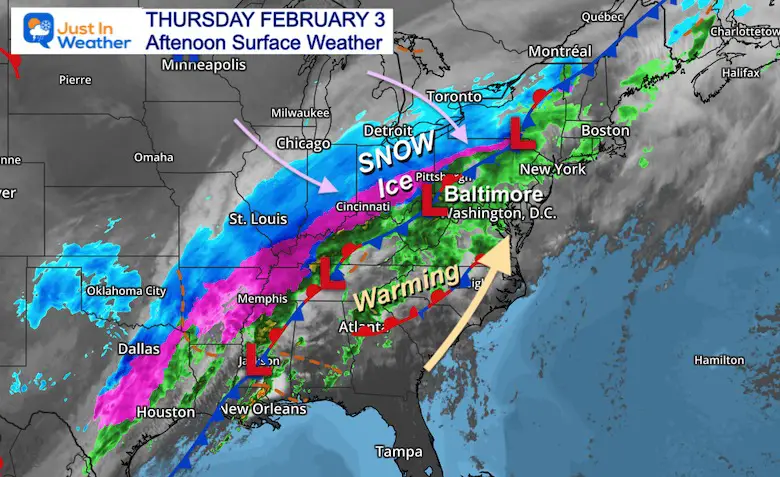
Wide View
Check out Texas Snow in Dallas and Freezing Rain in Houston!
That ribbon of snow and ice extends up to Western Pennsylvania now. Meanwhile warm air is streaming ahead of the boundary. That will be felt by tonight in central Maryland.
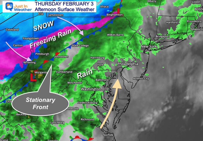
Closer View
The boundary of snow and ice is nearly stalled behind a Stationary Front. The slow down is what is making me question the ice forecast now.
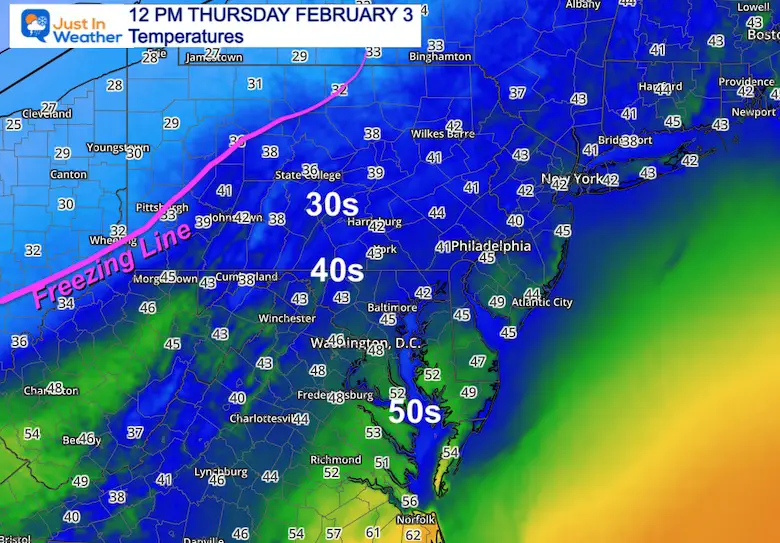
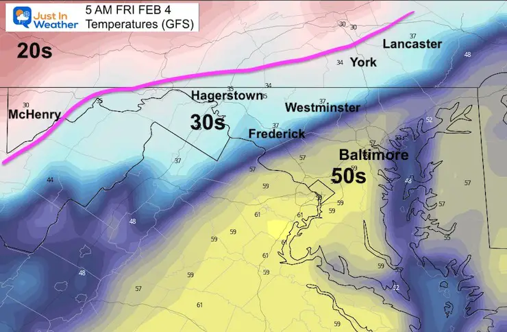
Temperatures
What a big spread from the 20s in Erie, and near freezing in Pittsburgh, while most of our region is in the 40s.
Even warmer 50s in Southern Maryland and 60s near Norfolk, VA. The warm air will be heading our way through tonight.
What we know for sure:
Rain will continue and may be heavy at times.
Temps will be warming up through midnight. The high temperatures on Friday will be early morning.
Colder air will arrive Friday morning, and bring many down into the 30s or colder.
Most of the region will be below freezing Friday evening. So anything wet, may ice up around sunset.
What I question now:
How fast is the cold air moving?
When will the ‘Freezing Line’ arrive?
Where will it reach by 6 AM or 7 AM?
The result will determine where roads turn icy OR stay wet?!?
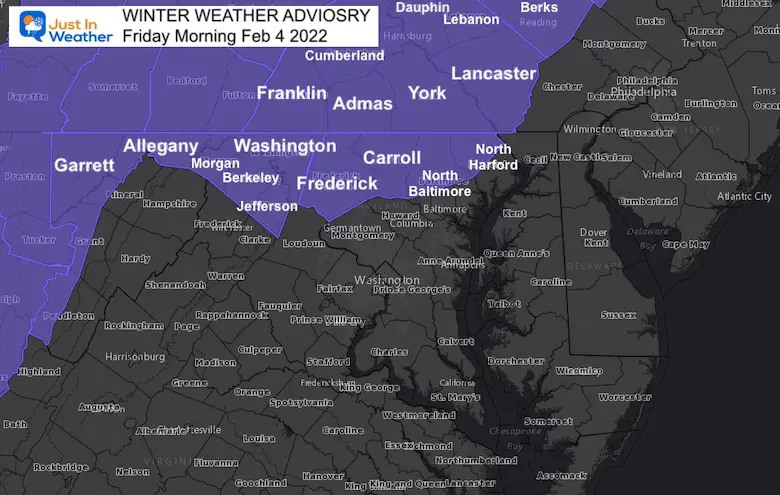
These are the official alerts from the National Weather Service. This is where the freezing line is likely to arrive in time for the warmer, wet ground to ice up.
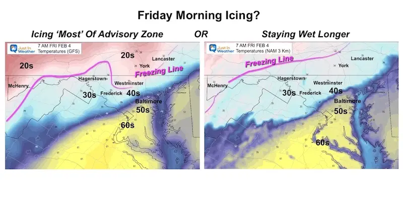
Here’s the Dilemma
Model Comparison
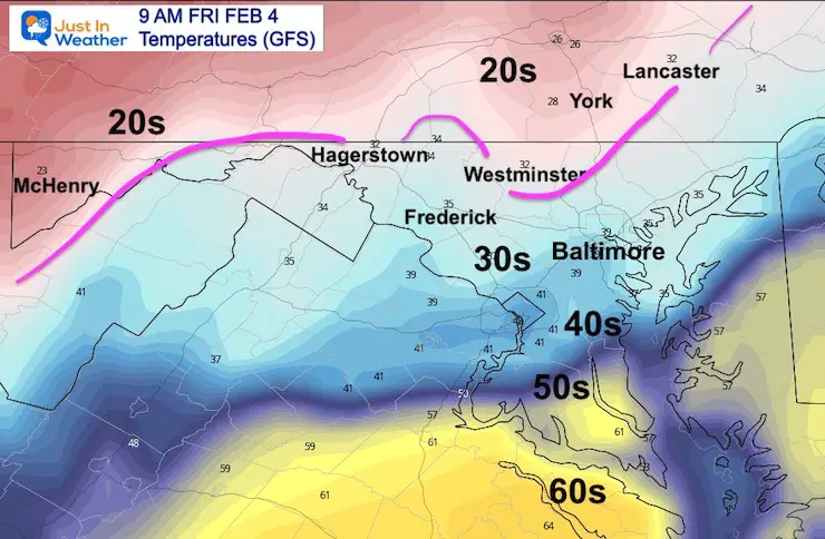
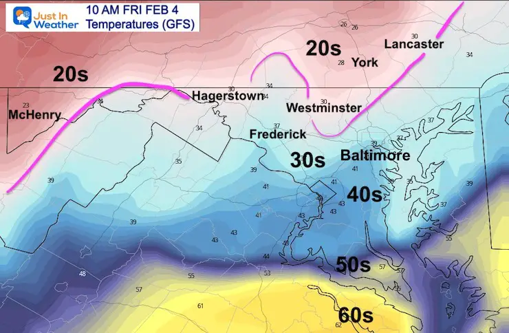
The GFS Model (left) is slower, but brings in the cold air before sunrise for Westminster to York and Lancaster.
The NAM 3 Km Model (right) is a higher resolution model that performs well in this tine frame. It did speed up the cold air tester, now pulled back again…. Keeping even York and Lancaster in the rain through sunrise.
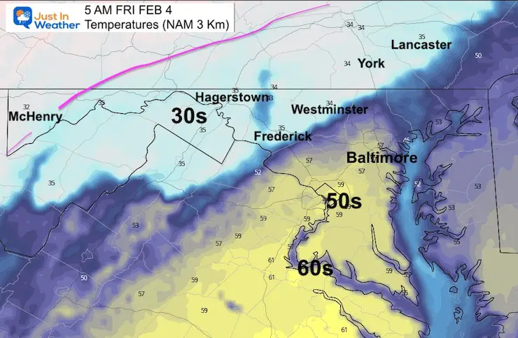
See the two timeline sliders below
REMINDER I have been focused on timing as the KEY element to determine who may ice up Friday morning.
When an ice event starts with freezing rain or sleet, it is much different than a warm rain turning colder.In this case, we will have temps in the 40s and 50s with rain warming the ground, then turning colder.
That takes time to chill and allow pavement to catch up and ice over.
For any impact on the roads, I would suggest this:
The Freezing Line must arrive by around 6 AM. This allows about 2 hours until the sun angle is high enough in the sky (through the clouds) to help warm the pavement.
Places that drop below freezing that early, are more likely to have icing on the roads and impact travel for work and school.
Places that drop below 32ºF later, there may still be freezing rain, but more impact on car windows, signs, trees, and power lines.However the road would be more likely to stay wet.
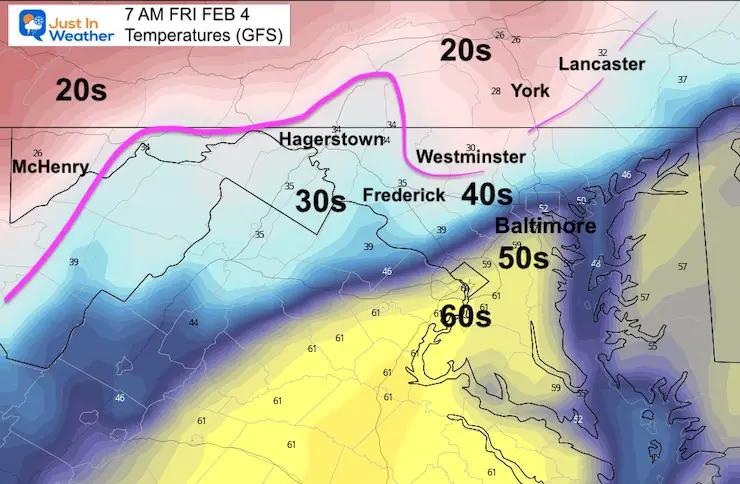
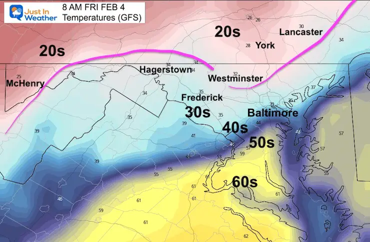
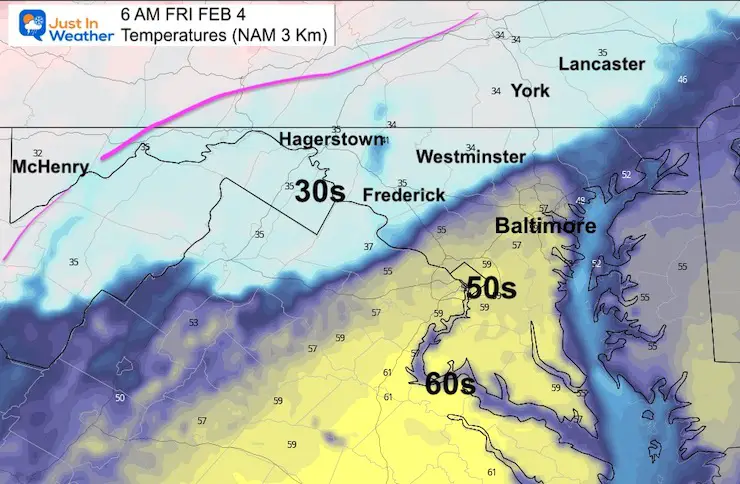
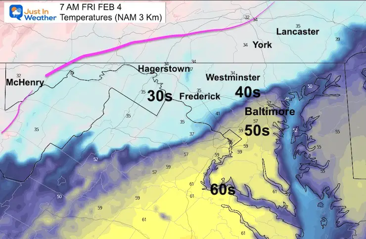
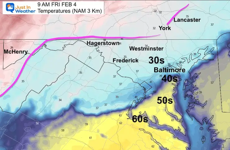
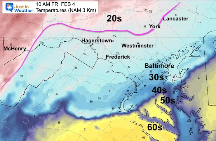
Temperature Timeline —> sliders
Note how much warmer it will be in metro Baltimore at 4 AM (50s) compared to the drop by 8 AM to 10 AM (30s). This may help explain why your Weather App is showing a high so warm. Make sure to look at the hourly breakdown. We should all be below freezing by evening.
GFS Model- The colder version now.
This has trended slower as well. Frederick and Hagerstown my just barely escape prime ice risk.
Again:I just want to open the door to possibly adjusting the morning ice zones. I am not changing it yet. However, I will have an update late and may pull the plug for some. Also be aware some of the Advisories could get dropped or pushed back later. There still is the risk of icing for more at the end of the day.
*Garrett County will definitely get in on Friday morning ice!
My ‘Likely’ Icing map be update. Stand by for my next report later today.
I am aware there are some spelling and grammar typos. I have made a few public statements over the years, but if you are new here you may have missed it:
I have dyslexia, and found out at my second year at Cornell. I didn’t stop me from getting my meteorology degree, and being first to get the AMS CBM in the Baltimore/Washington region.
I do miss my mistakes in my own proofreading. The autocorrect spell check on my computer sometimes does an injustice to make it worse.
All of the maps and information are accurate. The ‘wordy’ stuff can get sticky.
There is no editor that can check my work when I need it and have it ready to send out in a newsworthy timeline.
I accept this and perhaps proves what you read is really from me…